|
December 27, 1970: The Bob Hope Christmas Show at RC#1 |
|
October 23, 1970: General Matheson's Departure Ceremony |
|
Return to the Index for 1970 |
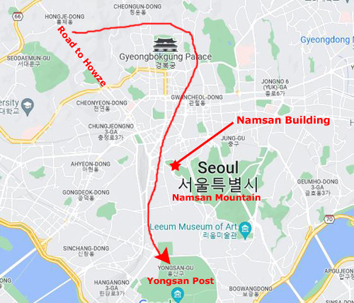
Today, on my off time, I'm going to head into Seoul for a walkaround. It's well into fall, and the heat is gone. In fact, it is about 65 degrees today, so walking around, even up and down hills, is actually a pleasure. I am planning today on going someplace different.
I have made quite a few excursions around the city, but it's been along the city streets and markets, or at Namsan Mountain, or near Yongsan. When I've done this, I have always looked up the hills that surround the city, and noticed that houses, buildings, and shanties creep almost to the top of these mostly rocky hills. It is here that I want to explore today.
Introduction/Comment from 2022
|
This was not very difficult to do. All my Seoul walks end up at Yongsan Army Post, which is where I usually have dinner before getting the late military bus back to the Second Division area. Since I was walking through hills, and the only thing south of Yongsan is the Han River, the Yongsan Post had to be the southern boundary of my walk area.
Next, I always took the same Korean bus from Bong-il-cheon into Seoul, and I was quite familiar with which road comes into the city from Howze, and which major street it follows as it comes down into the city. I recall that when I got off the bus, the hills I wanted to explore were on my left- east of that major street, so the road to Howze must be the western boundary of my walk area. Also, I know about where the bus station is where the Bong-il-cheon bus stops, and so that must be pretty much the northern boundary of my walk area.
As for the eastern boundary, I have to estimate. I seriously doubt I would have gone more than a mile or two east after getting off the bus, as I spent all my time in the hills I could see just to the left of the bus before I got off. So given all this, I can estimate the area I covered this afternoon.
As you will see a bit later on this page, I am able to correlate part of my walk because I happened to photograph a scene that still exists- fifty years later.
My Walk Through the Hills Above Seoul
|
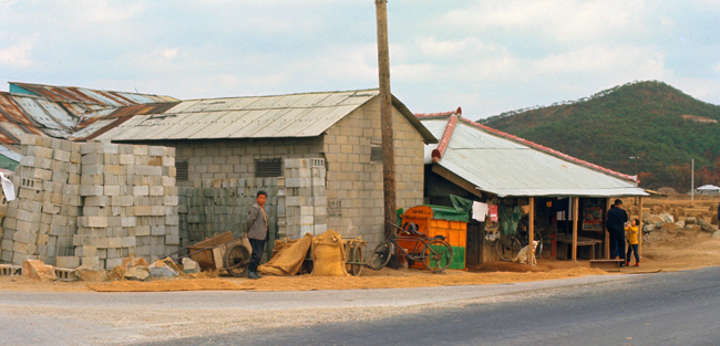
The bus stop is just across the highway, and just across the intersection of the road that leads up to the Camp Howze entrance gate and the highway. The buildings shown at left are at that corner, opposite from the bus stop. It is hard to tell from the outside whether the building is a store or a residence, but our Finance Office accountant, Sammy Ko, told me once that it is actually a rice mill.
Today's ride into Seoul was very pleasant. The heat of summer has long since dissipated, and now riding in the Korean buses (which are, as you would expect, not air-conditioned) is not the unpleasant experience it can be in the summertime.
|
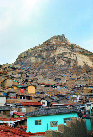
My intention was to hike/walk up the hill you see in the picture at right. I had a number of objectives. One was that I hoped to get a good view of the city from the top (or as close to the top as I could get). Another was to explore the housing that I could see going up the hill
|
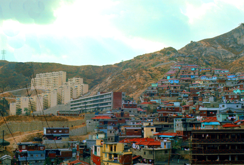
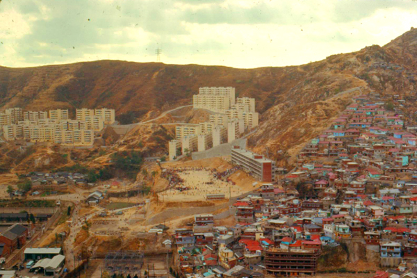
I could have chosen to head to my right and walk up through the housing that I could see going up the slopes of the hills on the west side of the street (that's the picture at left), but I decided against doing that for a couple of reasons. First, it seemed to me that the housing on the west side was newer (note the high-rise apartments you can see in the photo), and so I thought that looking at the older housing might be more interesting.
In addition, it looked like quite a long walk to get up to the ridgeline that would offer good views of the city, and I wasn't sure how much time that would take. The rocky hill on the east side of the street seemed much closer. Furthermore, heading west would take me further from Namsan Mountain and Yongsan Army Post rather than generally closer, and again I wasn't sure how much time I would have today. So for those reasons, I crossed the street and then just began to follow the street that headed uphill- a street that very quickly petered out and turned into a series of rabbit-warren alleyways that led between the dwellings and up the hill.
|
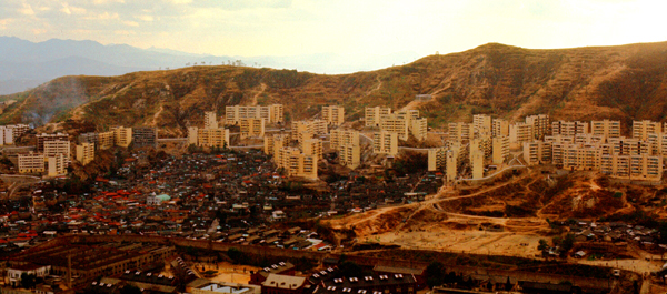
I think that this picture is a good one to illustrate the changes that are happening here in South Korea and there is the obvious contrast between the older housing in the nearground and the new highrise-housing in the background. This is what is happening all over town, and you've already seen new buildings in many of my pictures (although not out in the countryside).
Looking at these highrises, I wondered to myself what the apartments inside might look like. The only actual city dwelling I have been in is Dr. Kim's house down near Yongsan, and that, I think, was an older structure. Even though the Kim family was decidedly upper-middle-class, the house was lacking in the facilities- particularly plumbing- that we are used to in the States.
I wondered if this would be different in these highrises. Certainly these structures could not rely on the same process as Dr. Kim's house for waste disposal (which, for Dr. Kim, was something akin to a basic septic system, rather than city sewers, complicated by a lack of the sinks, showers, and flushing toilets that the vast majority of Americans are used to). It would seem that highrises of this size would require more sophisticated systems, although I suppose it is possible that water and other water-based facilities might only be available communally on the ground floor. It was musings like this that made me wish I could tour one of these new highrise buildings. I actually only got to go inside one of these new buildings during my stay here, and that was only to get some photographs from a high floor.
|
|
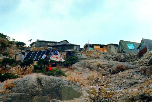
We may have slums in the States, but at least people don't have to live in tents. The wind on this mountain is strong, and even with a heater it must be frigid in these hovels. Every winter, many people die in areas like this. Some die when they are not able to keep themselves warm, and other suffocate because they are using charcoal space heaters to try to stay warm. In the States, these people would be classified as homeless, and the government would support them. I don't imagine that these people get any support, so they have to get along on their own. They probably don't have much choice.
Note from the present:
That last paragraph that I wrote in 1970 seemed oddly out-of-touch when I included it on this page today. Homelessness is currently a problem in many US cities, and my thought that in the States, the government would take care of them seems naive, as many US cities are definitely not doing that.
Another note from the present:
As I've mentioned before, one thing that I like to do in my photo album is to try to place, as accurately as I can, just where I was when a particular photo was taken. For photos taken only a few years ago, the aerial views available to me are quite enough for me to be able to match up with and geolocate my position.
|
This is particularly true in areas that are growing or changing rapidly, and Seoul falls into this category. A huge percentage of the structures you have seen in the pictures on this page are no longer in existence. Certainly the shanties here on the hillside are long gone. Even the relatively new highrises on the hillsides to the west are gone- at least I can locate no remotely similar structures on those hillsides today. So locating just where the hillside I am currently on would seem to be very difficult, but as luck would have it, a couple of my photographs gave me a clue that enabled me to locate my position fairly precisely.
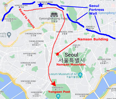
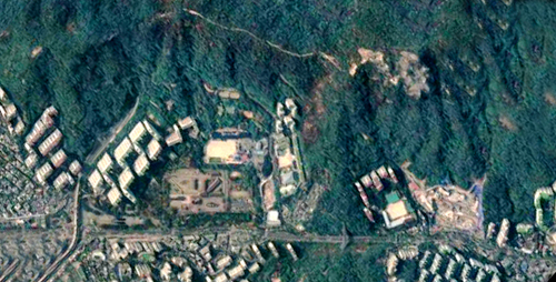
First, I want you to look at the map at left. It is the same as the one at the top of this page, although I have made one addition. Working from diagrams I have been able to find, I have also drawn in some of the remaining segments of the ancient Seoul Fortress Wall, a defensive fortification that dates to the 1400s. These segments are approximate; only about a third of the original fortification still exists. (The lines that I have drawn don't represent the extent of the actually fortress wall remnants.)
Before I get into just how I know, the rocky hill I am on is located pretty much where the blue star is on the map above. There are two clues in the photographs I took today that allow me to make this statement with a fair amount of confidence.
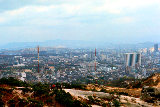
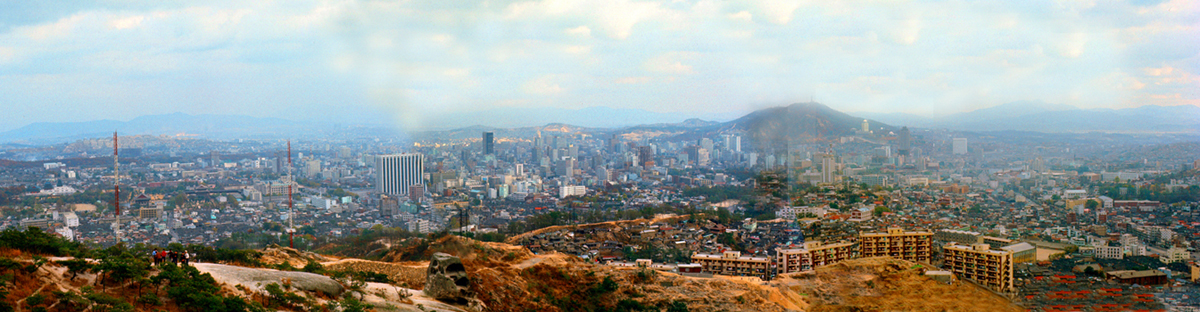
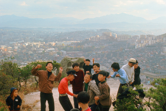
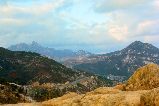
As I walked around to the east side of the hilltop, the views to the south of the city of Seoul opened up, and I started snapping away, recording the impressive view. First, I want to show you the three pictures I took looking across Seoul that together provide a panoramic view of the city spread out before me.
|
First, please note the large new skyscraper at the center right in the photo. You have seen this building before, as I took some pictures of it during my walking tour of Seoul back in September, pictures which appear on the page for that walk. The position of this building enables me to say that the green area between the two radio towers is in fact the Gyeongbokgung Palace, another site that I visited during that walk.
So, looking at the map above, you can see that for me to be able to take a picture looking at the palace, I could easily be standing at a point quite close to the blue star on that map.
There are two other items of interest here though. Look first in the lower right, and you will see a stretch of what appears to be a high stone wall. It seems to climb partway up the hill and also extend down the hill a ways. This is a segment of the ancient Seoul Fortress wall, and again this jives with my being somewhere close to the blue star on the map.
Finally, look closely at the lower left, and you will see a group of people stading on the hillside below me. You will see these people again.
|
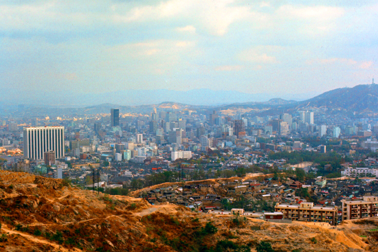
In this view you can see the same skyscraper that you saw in the previous picture, but now you can see further around to the west as we look out across the center of Seoul.
Interesting aspects in this picture are that you can see how the fortress wall continues down the hill for a ways before apparently stopping in that green area at center right. You can also see that there are some relatively new apartment buildings at the base of the hill I am on. (Researching the aerial views led me to conclude that these structures no longer exist.)
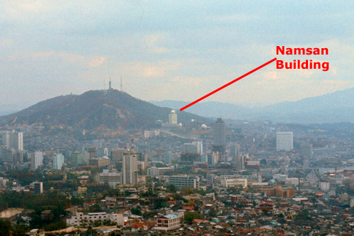
The hill in the background, at the right of the picture, is Namsan Mountain, and so if you refer to the map above, you will see that seeing it from this angle is also consistent with a position near the blue star.
This is a good view of the main city center (and you might compare it to the pictures I will take of Tokyo on my first trip there next year). It is this area of Seoul that most closely resembles the States, but still there are little subtle differences that make it forever foreign, much though it may look like a US city.
|
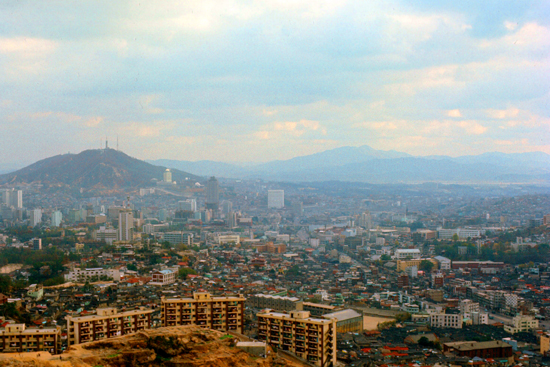
In the distance you can see the rest of Namsan Mountain, easily-identified by looking at the tall white building on its western slope (the right-hand slope in this picture). You have seen this building before, on the same page for my walking tour around Seoul in September.
This building, seen from this angle, provides the third and conclusive clue to the conclusion that these three pictures were all taken from a point near the blue star on the map. Knowing that, I went to the aerial views to see if I could see the spot from above, but what I found was pretty interesting.
It appears that sometime in the last half century, all of the hovels and shanties that I saw today on the hillside have been utterly swept away; I can find no trace of them. Nor, actually, can I locate the bare rock area where I was standing, as the entire area seems to have been turned into greenspace, and is now covered with vegetation. There are still some isolated streets and structures, but almost nothing that I can recognize. If the clues so far (and some coming up) hadn't enable me to place the position, I would never have found it, so great have the changes been since 1970.
Note from the present:
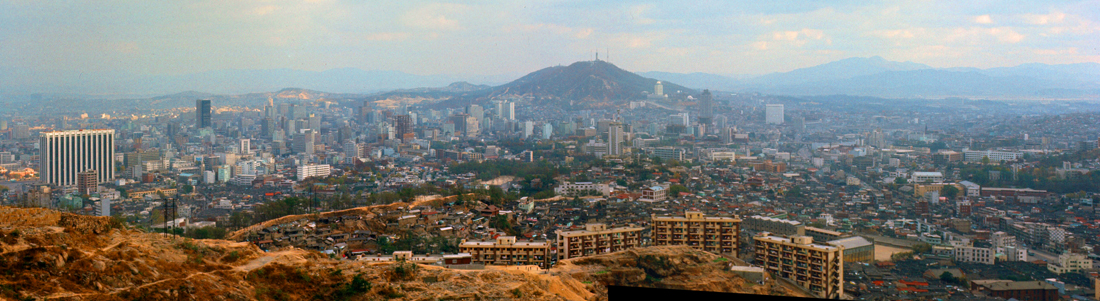
In all my investigation utilizing the previous three pictures, I noticed something interesting. Those three pictures together present a panoramic view of most of the city center; you can see that as you move from one to the next. Today, I have the capability of stitching those three pictures together. Two of them, the second and third, fit together perfectly, since I took them from the same spot at the same time:
|
The first picture was taken a few minutes later and from a slightly different spot, so when I tried to add it to the other two to extend the panorama to the east, I had to do a bit of photoshopping to blur out the inconsistencies in the "fit" between the pictures:
|
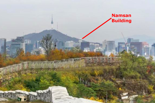
Now for something else interesting. In looking around for some way to identify the route of the Seoul Fortress Wall, I found a picture online taken from the area where I was walking through, although it was of course much more recent, having been taken in the past few years. But it offered a stark contrast showing how much the city has changed. Below, I have taken that picture and put it alongside a portion of one of my own pictures, matching the view direction as much as possible. And I have point out the one building that existed both then and now so you can relate the two pictures together:
|
|
As you can see, the only difference in the two perspectives is that the recent picture was taken from a point much lower down the hillside, perhaps because the place I was standing now seems to be forest, and the view would be obstructed by trees or other vegetation. But the building on Namsan Mountain is hiding in the same place. (Incidentally, the Lotte World Tower, South Korea's tallest building and the sixth-tallest building in the world (tie) is located out of the 2020 view to the left of Namsan Mountain, way across the Han River. Of course, it doesn't appear in any of my pictures at all.)
|
|
I am pretty sure that the buildings in my photograph are not the ones you see in the aerial view, as I doubt that with as much rapid development as Seoul has undergone that those buildings would still be in use today. City services were still fairly primitive by our standards in 1970; I saw no evidence that sewers and water mains had been built in these areas, so my guess is that these facilities were perhaps on the ground floors of these 6-10 storey buildings. I doubt that Seoul dwellers in 2020 would have any interest in such an arrangement.
Certainly in the aerial view there are lots fewer buildings than you see in my picture, and the buildings that do exist seem to be in a different orientation to the ones I photographed. It would be interesting to get the input of some Seoul history buff or historical society, and I have tried to do that, but have to date gotten no responses.
|
|
In my walks through Seoul, this has been a constant theme. Almost all adults treated me as just another passerby; although I looked a good deal different from all of them, I never got a second glance. The story was different for teens and younger kids. The youngest always seemed to want be in pictures (and I did notice Korean adults taking many pictures of their kids as well). Maybe this is an urge that all kids have, I don't know. And the teenagers, when they realized I was American (or at least foreign) wanted to try out the English that they were learning in school. I certainly understood that desire; why learn something if you can't use it? That was one of the reasons that Koreans like Dr. Kim arranged for American soldiers to be something like "exchange students" in their homes; it gave them and their children a chance to hone their English skills.
|
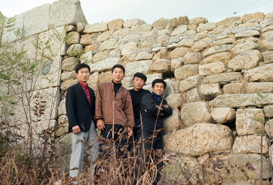
When my slide came back a month later, I had a print made at the PX, and with the help of Sammy Ko, our Korean accountant, I was able to address a letter to the young man and send the picture off to him.
The Fortress Wall of Seoul (the Seoul City Wall) is actually a series of walls made of stone, wood and other materials, built to protect the city of Seoul against invaders. The wall was first built in 1396 to defend and show the boundaries of the city, surrounding Hanyang in the Joseon Dynasty.
The wall stretches 12 miles along the ridges of Seoul's four inner mountains, Bugaksan, Inwangsan, Naksan and Namsan. At present, the wall is designated as Historic Site No. 10 (this was done in 1963) and is protected accordingly, along with the gates, water gates, and signal fire mounds. The northern, eastern, and southern sections of the wall on Namsan mountain have undergone extensive restoration work, having sustained damage or been entirely destroyed during Japanese imperial rule (1910–1945).
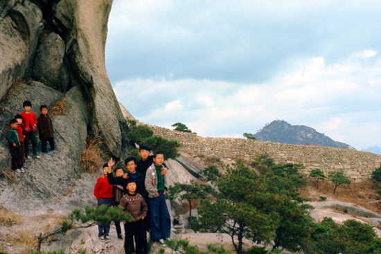
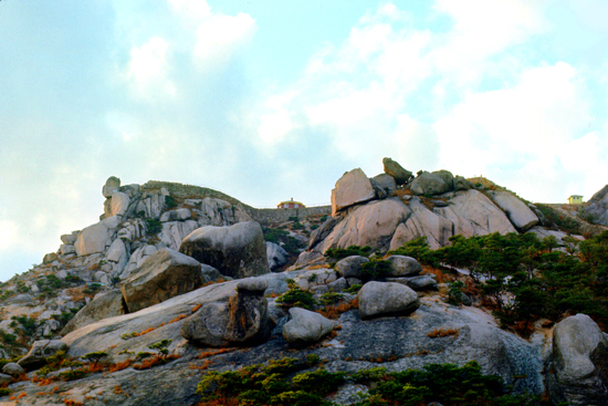
The section of wall on this particular hillside seems to be in relatively good repair, and I also found it interesting that right at this point the appearance of the wall changed due to an apparent change in construction materials. It almost looked as if restoration work had been done here as well. The young men also showed me a place where I could climb up to the top of that section of the wall at left, and from there I got some excellent pictures of the Blue Mountains on Seoul's northern perimeter:
|
|
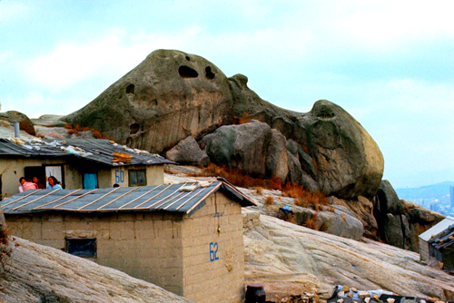
I very much enjoyed walking around here on this rocky peak, and seeing some of the housing near the top was an eye-opener, as it was an area unlike any I had been through before. But I had a ways to go to get to Yongsan Army Post, so I said goodbye to the youngsters (some of whom followed me for a ways) and I headed down the hill alongside the fortress wall, heading south towards Namsan Mountain.
|
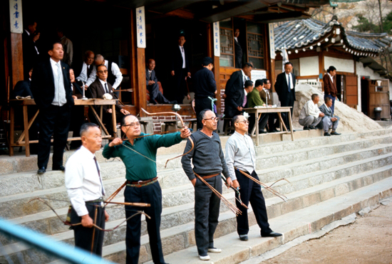
On my descent, I eventually left the rocky area and got down to an area that was more suitable for building, and the first structure I encountered seemed to be an archery club of some kind. There were a couple of buildings and quite a few men about.
There was no fence (as one might expect in the States) so I was able to walk right alongside the archery range where I got the picture at left of the four gentlemen practicing their skill, with the targets set up some distance away in front of a wall. Of course, what they were doing was obvious, even though I couldn't understand anything they were saying- save for the occasional "Hello" I got from one person or another. My "Good afternoon; how do you do?" in halting Korean seemed to be well-received.
I continued making my way towards Namsan Mountain and Yongsan Army Post beyond, enjoying the walk in the cool Fall air through the immensely interesting city streets. I reached Yongsan about 6PM, picked up more film at the PX and had my dinner (my favorite Mongolian BBQ) at the Officer's Club, and then waited in the club for the next bus departing to the Second Division area and Camp Howze. As usual, I was home by ten.
You can use the links below to continue to another photo album page.
|
December 27, 1970: The Bob Hope Christmas Show at RC#1 |
|
October 23, 1970: General Matheson's Departure Ceremony |
|
Return to Index for 1970 |