|
October 6-18: A Business/Pleasure Trip to England |
|
September 5, 1977: A Visit to Mt. Rainier, Washington |
|
Return to Index for 1977 |
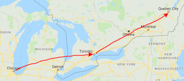
One of the sales we realized as a result of the good words about us from Caisse Populaires was National Revenue Taxation Canada in Quebec, the Canadian Equivalent of the IRS. This time I was careful to ascertain whether or not the class attendees spoke English. It turned out they all did.
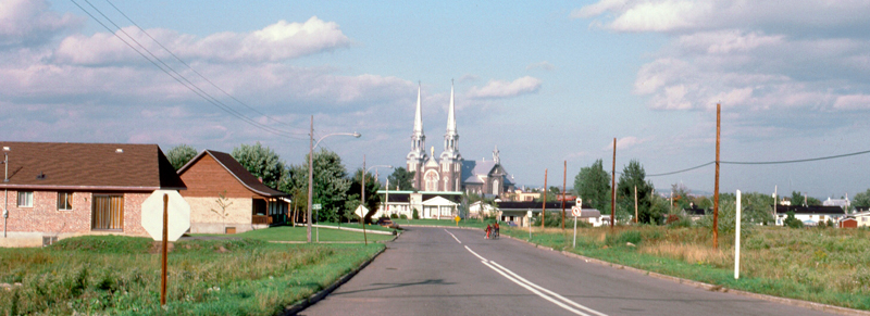
Traveling from Chicago to Quebec City
|
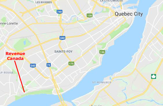
The Québec City Airport is located about 7 miles from downtown, southwest of the city. It is a very busy airport, but pretty easy to get into and out of.
|
I did not write down in my picture notes just what hotel I stayed in, but then that's not really important.
The purpose of this page is, of course, to hold and describe the various pictures I took on the evenings when I went out around the area to have a look at this very old city.
My Pictures of Quebec City
|
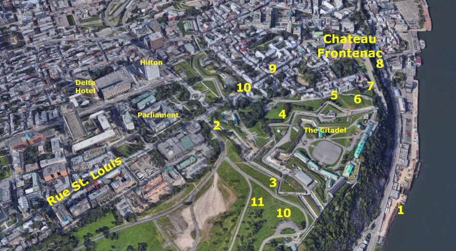
On that aerial view, I'm going to mark many of the locations where I took my various pictures and, where I think you might be interested, I might also show you a closer aerial view that relates to a particular picture.
Keep in mind that while my pictures were taken in 1977, the aerial view is probably from around 2016, and so you should expect a lot of changes in the forty years that elapsed between the two. I'll mention some of these changes as we go.
I might also say that if you find Quebec City to be interesting, based on the pictures I have here, but you have no plans to go visit yourself, you might want to go to the album page for 2018 that covers a visit that Fred and I, along with five of our very best friends from San Antonio, made to Quebec City. I will have a digital camera then, and so there will be lots more pictures. In fact, you'll see some of the same views taken from almost the same places, and you'll be able to see the dramatic changes that have occurred in Quebec City since this particular trip. Just go back to the year index, choose 2018, and find the Quebec City visit in the list of trips and activities.
|
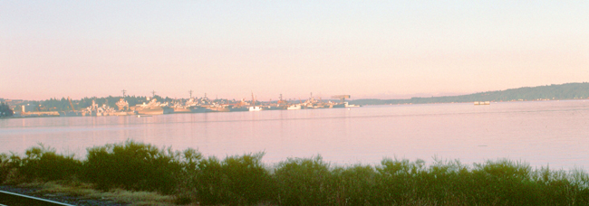
Although, looking at the picture (taken at #1 on the aerial view), it seems as if at least some of the ships you see docked on the south side of the river aren't commercial; they look more like military craft. If they are, I have no idea why they are here in Quebec City.
Quebec City is, of course, the capital city of the Canadian province of Quebec, and has a population of around 400,000. The Algonquian people had originally named the area Kébec, an Algonquin word meaning "where the river narrows", because the Saint Lawrence River narrows at the promontory of Quebec. Explorer Samuel de Champlain founded a French settlement here in 1608, and adopted the name.
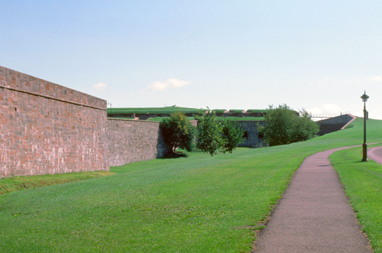
I had actually parked my car some block southwest on Rue St. Louis where I found some parking on the street. Then I walked up that street towards Old Quebec. Just before I got to the Porte St. Louis, I noticed that there was a large park off to my right.
|
The Plains of Abraham is a historic area within The Battlefields Park in Quebec City. The land is the site of the Battle of the Plains of Abraham, which took place on 13 September 1759, but hundreds of acres of the fields became used for grazing, housing, and minor industrial structures. Only in 1908 was the land ceded to Quebec City, though administered by the specifically created and federally-run National Battlefields Commission. The park is today used by 4 million visitors and tourists annually for sports, relaxation, outdoor concerts, and festivals.
The plains are likely named after Abraham Martin (1589–1664), a fisherman and river pilot called The Scot. Martin moved to Quebec City in 1635 with his wife Marguerite Langlois and received 32 acres of land from the Company of New France, land divided between the lower town and promontory. Abraham's name appears in deeds recording the land, and a 1734 plan even precisely locates an Abraham Street. Later, the journals of the Chevalier de Levis and the Marquis de Montcalm referred to the Heights of Abraham, as did the diaries of British soldiers, who also employed the phrase "Plains of Abraham".
The park itself presently occupies an area approximately a mile and a half by a half mile extending on top of the bluffs above the Saint Lawrence, westward from the Citadelle of Quebec and the walls of Quebec City and forms a part of The Battlefields Park.
|
In 1759 the area was the scene of the Battle of the Plains of Abraham, part of the French and Indian War. On that date, British soldiers under the command of General Wolfe, climbed the steep cliff under the city in darkness, surprising and defeating the French, through a single deadly volley of musket fire, causing the battle to be over within 30 minutes. Both Wolfe and the French commander, the Marquis de Montcalm, died of their wounds, but the battle left control of Quebec City to the British, eventually allowing them to take control of Canada the following year.
The plains remained nondescript fields, with only a monument to Wolfe as a reminder of the events that took place. As Quebec City grew, the area was developed until in 1901 Canada purchased much of the undeveloped land. Various proposals were put forward to set the area aside as a landmark or perhaps a park In 1905, a proposal was placed before the Royal Society of Canada and Governor General to preserve the battlefields. The Governor General had visited the site and declared that he "would never rest until such sacred ground became the heirloom of all Canada and the Empire."
In 1908, a commission appointed by the Mayor proposed the nationalization of the Quebec battlefields and the construction of a museum of Canadian history. The federal prime minister at the time, Wilfrid Laurier, suggested, however, that a preservation of the plains themselves would be a more fitting tribute. The park was created that same year- becoming the first National Historic Site in Canada. The official dedication occurred on 24 July 1908 when the King's eldest son, Prince George, Prince of Wales (later George V), dedicated the Quebec Battlefields Park at the Plains of Abraham, then presenting the title deeds of the lands to the Governor General.
|
I next walked around the northwest side of the Citadel itself. The Citadel of Quebec is an active military installation and the secondary official residence of both the Canadian monarch and the Governor General of Canada. The citadel is the oldest military building in Canada, and forms part of the fortifications of Quebec City. It is also a National Historic Site of Canada. The only way to visit it is by taking an official tour, which some 150,000 people do each year.
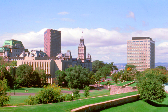
From just below the walls of the Citadel, on its north side, I took the picture at left that looks northwest across the newer area of Quebec city. The two tall buildings are the Delta Hotel and the Hilton Hotel, and prominent in the center of the picture is the Quebec Parliament building. You can also see, in the greenspace, more of the restored walls that surround the old city.
I continued walking around the outside of the Citadel, just below the star-shaped walls, and my view changed to where I could get great views of the old city, which extends from the city walls to the river.
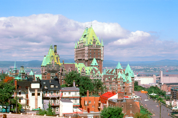
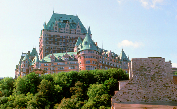
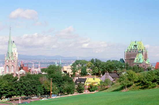 (#5) Looking in to the Old City, you can see the United Church of Canada at left and the Chateau Frontenac at right, as well as other old, copper-topped buildings scattered through the area. I was impressed by the Old City and its cleanliness and upkeep. (The new part of Quebec City was also neat and clean.) |
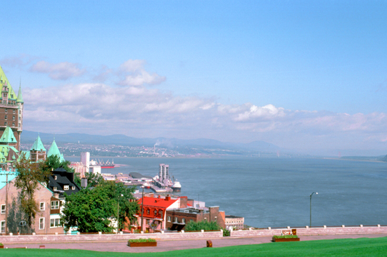 (#6) Taken from a little different vantage point, you can see the Chateau Frontenac at left, the Dufferin Terrace below it, and a wide expanse of the Saint Lawrence River. This view looks downriver to the east. Like other cities with water and mountains, Quebec City is quite beautiful. |
I think you can see from the views above how defensible Quebec City actually is, being high on a bluff overlooking the river. The first actual settlement was at the base of the escarpment, but soon most of the people and buildings moved to the top of the cliff. Once the city walls were built across the escarpment on the west, the city was among the most defensible in the New World.
|
Opened in 1893, the Châteauesque-styled building is 262 feet tall with containing 18 floors. In the 1870s, a restoration project began in Quebec under the British governor general of Canada aimed at restoring the capital to its former 17th century look. One of the contributors to this project was Lord Dufferin, who supervised the construction of the old city wall and many public buildings that followed the theme of old, medieval, European Quebec. Dufferin also made a plan to reconstruct the Chateau Saint-Louis which was located on the cape where the Chateau Frontenac currently stands and served as the home of the French governors from 1620 to 1834. The City Council adopted the plan and planned to construct a grand hotel to attract upper-class tourism, but couldn't arrange for financing. Subsequently, businessmen from Toronto and Montreal with connections to the Canadian Pacific Railway took control of the project.
The Château Frontenac was designed by American architect Bruce Price and overseen by William Van Horne, the Canadian Pacific Railway's general manager and a key developer of the Canadian railway hotel system. The hotel was a part of a series of Chateauesque-styled hotels built for the Canadian Pacific Railway company during the late 19th and early 20th centuries. The hotel was expanded in 1924, and the hotel's central tower was added at that time. The hotel was named after Louis de Buade, Count of Frontenac, who was the Governor General of New France from 1672 to 1682, and again from 1689 to 1698.
|
I found some stairs I could take down from the Citadel to the Boardwalk (Dufferin Terrace) and then more stairs that I could take down to the "Lower Town". The Lower Town is a historic district located at the bottom of Cap Diamant. During 1608, Samuel de Champlain built a habitation (village) with Place Royale as its center. The area was reconstructed in the mid-1600s with the goal of reconstructing the French flair from its origins. Construction of the Church of Notre-Dame-des-Victoires started during 1687 in the Lower Town; it was completed in 1723. The Musée de la civilisation, the Musée naval de Québec, the caserne Dalhousie and the Théâtre Petit Champlain are among some of the museums, performance halls, theatres and exhibition venues in Lower Town.
I came back up to the long boardwalk just below the hotel (the Dufferin Terrace) and then walked around the north side of the structure and up Rue St. Louis.
|
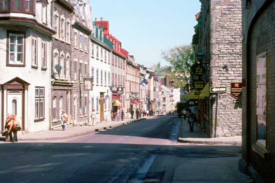
Most of the buildings in Upper Town date to the early 19th century. Military use did hamper growth in the Upper Town for many years, and a movement arose in the late 19th century to demolish the fortifications as obsolete and as an obstacle to urban development. It was Lord Dufferin who successfully persuaded officials to preserve and rebuild them. The area declined and fell into disrepair in the 1950s but new building began in the 1970s.
Sprinkled among the 19th century structures are a good many that date to the 17th and 18th centuries remain as well. The area has several commercial streets like Saint Louis, Saint Jean, Sainte Anne and De Buade. Some public administration and other institutions in the Upper Town are the Quebec City Hall (Hôtel de Ville, erected in 1896), the Séminaire de Québec, the Ursulines Convent, and the Augustinian Monastery and l'Hôtel-Dieu de Québec. There are many hotels, including the Château Frontenac, the Old City being a very popular tourist destination.
There are a number of parks in the Upper Town, although all of them are quite small. They include De l'Esplanade, Artillerie, Des Gouverneurs and Montmorency parks as well as the grounds of l’Hotel-de-Ville. More popular are the four or five public squares, each of which seems to have its own fountain.
|
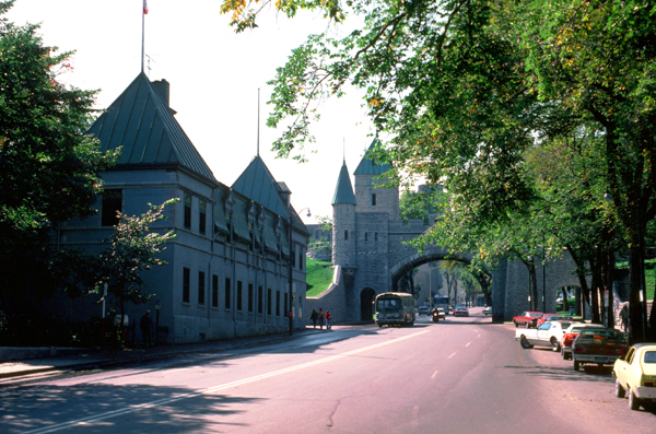
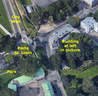
The ramparts have four surviving gates; one of them, Porte St. Louis (#10), was conveniently located on the street I used to drive into the old part of the city from my hotel further down the Saint Lawrence. You can see this gate at left.
|
As you can see in the aerial view at right, I have taken this picture from a little ways up Rue St. Louis towards the Old City (out of the aerial view to the right); I have marked both the gate and the building that you see to the left in my picture, so that information enables you to figure out where I was when the picture was taken.
Quebec City is one of the oldest European settlements in North America and although many of the major cities in Latin America date from the 1500s, only six cities were created earlier than Quebec City, which was established in 1541. Of these six, three of them are Canadian, while the other three are in what is now the United States. Can you think of what three cities these are? One hint is that two of them were not within the boundaries of the original thirteen colonies when they were established, but became part of the United States later on. When you have thought about it, click here and I'll tell you what they are.
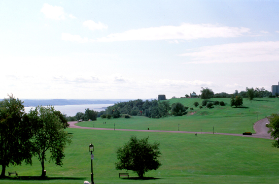
I continued down Rue St. Louis and through the gate, heading back to where I left the car. But I made one more detour into the Battlefields Park to take two more pictures.
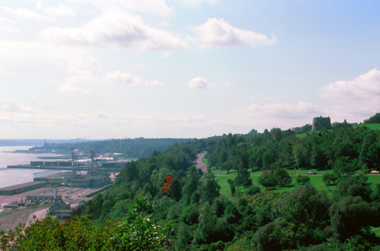 This view looks westward along the St. Lawrence from Battlefields Park. |
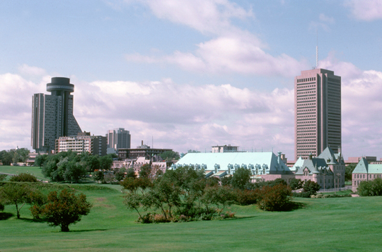 This view looks out across the new part of Quebec City towards the west. There's a new bank building and a hotel with revolving restaurant. |
I enjoyed walking around Old Quebec; it reminded me more of a European city as any other city I've been in (except for cities actually in Europe, of course). I didn't get outside the city much, but I understand that there is a lot to see in the area.
|
My flight back was uneventful, and I got back to my condo about 9PM.
You can use the links below to continue to another photo album page.
|
October 6-18: A Business/Pleasure Trip to England |
|
September 5, 1977: A Visit to Mt. Rainier, Washington |
|
Return to Index for 1977 |