|
Return to the Index Map for My Trip to England |
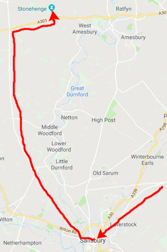
The day after my trip to Shakespeare's birthplace in Stratford-upon-Avon, I did my second day trip outside London, this time to the southwest to Stonehenge. All the time growing up and in school, I'd seen many pictures of the site, and the history of the Druids had figured into a number of classes through high school and college. I was looking forward very much to this visit, but even so, I wasn't prepared either for what I found or the effect it had on me. To see where we're heading, watch the movie below:
Now let's take a trip to Stonehenge for real.
At Stonehenge
|
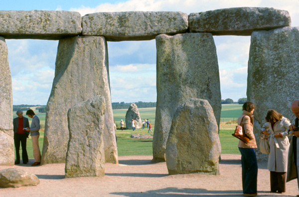
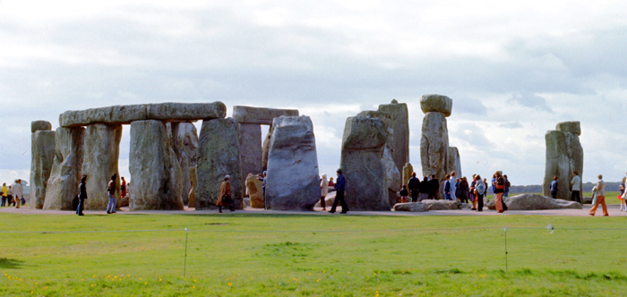
British Rail has a very good one-day trip to the area, one that leaves Waterloo station at 9 a.m., and arrives in Salisbury about 10:45. There, special coaches meet the train and drive out to Stonehenge itself, where one is free to wander around for hours, catching any of the coaches back to the station. The whole trip costs five pounds twenty, or about $10. This was my first view of Stonehenge when we disembarked from the bus:
 |
NOTE:
I was lucky to do this trip now, for in the years to come, Stonehenge will be closed off to any but guided tours. You will still be able to go there and walk close to the stones, but not actually wander among them. Today, we were just asked not to climb on the stones, but you could get right up to them for pictures, and touch them as well.
|
Archaeologists believe Stonehenge was constructed from 3000 BC to 2000 BC. The surrounding circular earth bank and ditch, which constitute the earliest phase of the monument, have been dated to about 3100 BC. Radiocarbon dating suggests that the first bluestones were raised between 2400 and 2200 BC, although they may have been at the site as early as 3000 BC.
One of the most famous landmarks in the United Kingdom, Stonehenge is regarded as a British cultural icon. It has been a legally protected Scheduled Ancient Monument since 1882 when legislation to protect historic monuments was first successfully introduced in Britain. Stonehenge is owned by the Crown and managed by English Heritage; the surrounding land is owned by the National Trust.
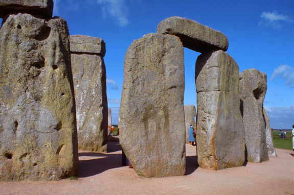
Stonehenge could have been a burial ground from its earliest beginnings. Deposits containing human bone date from as early as 3000 BC, when the ditch and bank were first dug, and continued for at least another five hundred years. I want to say at the outset that as soon as I got off the bus and walked towards the stones, I began to get an unusual feeling- all in my head, of course- but still palpable. And there were times during my visit when very few other people were within my view, and then the feeling was accentuated. I can only imagine what it must be like to be here without anyone else around, on a cloudy day in late afternoon.
|
The Oxford English Dictionary cites Ćlfric's tenth-century glossary, in which henge-cliff is given the meaning "precipice", or stone, thus the stanenges or Stanheng "not far from Salisbury" recorded by eleventh-century writers are "supported stones". William Stukeley in 1740 noted that "...pendulous rocks are now called henges in Yorkshire...I doubt not, Stonehenge in Saxon signifies the hanging stones". Christopher Chippindale's Stonehenge Complete gives the derivation of the name Stonehenge as coming from the Old English words "stan" meaning "stone", and either "hencg" meaning "hinge" (because the stone lintels hinge on the upright stones) or "hen(c)en" meaning "hang" (though elsewhere in his book, Chippindale cites the "suspended stones" etymology).
The "henge" portion has given its name to a class of monuments known as henges. Archaeologists define henges as earthworks consisting of a circular banked enclosure with an internal ditch. As often happens in archaeological terminology, this is a holdover from antiquarian use. Because its bank is inside its ditch, Stonehenge is not truly a henge site.
Despite being contemporary with true Neolithic henges and stone circles, Stonehenge is in many ways atypical; for example, at more than 24 feet tall, its extant trilithons' lintels, held in place with mortise and tenon joints, make it unique.
Archaeologists have found four large Mesolithic postholes beneath the nearby parking lot; these date to around 8000 BC. These held two-and-a-half-foot diameter pine posts in an east-west alignment which may have had ritual significance. A settlement that may have been contemporaneous with the posts has been found at Blick Mead, a reliable year-round spring one mile from Stonehenge. Studies have indicated that Salisbury Plain had various settlements long before Stonehenge was built.
|
The chalk dug from the ditch was piled up to form the bank. This first stage is dated to around 3100 BC, after which the ditch began to silt up naturally. Within the outer edge of the enclosed area is a circle of 56 pits, each about 3.3 feet in diameter, known as the Aubrey holes, and they may have contained standing timbers creating a timber circle, although there is no excavated evidence of them.
Evidence of the second phase of Stonehenge is no longer visible. The number of postholes dating to the early third millennium BC suggest that some form of timber structure was built within the enclosure during this period. Further standing timbers were placed at the northeast entrance, and a parallel alignment of posts ran inwards from the southern entrance. The postholes are smaller than the Aubrey Holes, being only around 16 inches in diameter, and are much less regularly spaced. At least twenty-five of the Aubrey Holes are known to have contained later cremation burials dating to the two centuries after the monument's inception, and so it seems that Stonehenge functioned as an enclosed cremation cemetery at this time.
Archaeological excavation has indicated that around 2600 BC, the builders abandoned timber in favour of stone and dug two concentric arrays of holes (the Q and R Holes) in the center of the site. The holes held up to 80 standing stones, and it is generally accepted that the bluestones were transported by the builders from the Preseli Hills, 150 miles away. These monoliths were only about six feet tall, but for the first time precisely matched the direction of the midsummer sunrise and midwinter sunset of the period.
|
The inward-facing surfaces of the stones are smoother and more finely worked than the outer surfaces. The average distance between them is a little over three feet. It is thought that the ring was never actually completed. The lintel stones are each around 10 feet long, 3.3 feet wide and 2.6 feet thick. The tops of the lintels are 16 feet above the ground.
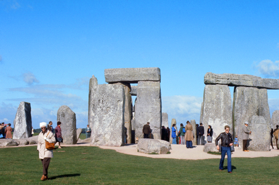
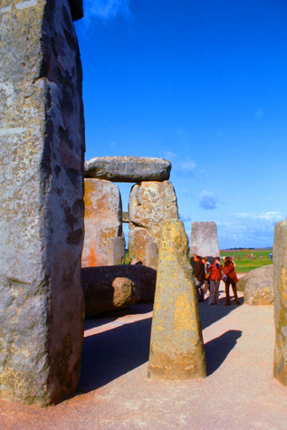
Within this circle (again, see my picture at left) stood five trilithons of dressed sarsen stone arranged in a horseshoe shape 45 feet across, with its open end facing northeast. These huge, 50-ton stones, were linked using complex jointing and arranged symmetrically. Only one upright from this formation still stands, of which 22 feet is visible and a further 7.9 feet is below ground. The images of "daggers" and "axeheads" have been carved on one of the sarsens; these are difficult to date, but are morphologically similar to late Bronze Age weapons. This ambitious phase has been radiocarbon dated to between 2600 and 2400 BC, and analysis of fossils and animal teeth found 2 miles away at what archaeologists think may have been the builders' camp, suggest that as many as 4,000 people gathered at the site for the mid-winter and mid-summer festivals.
|
|
There were further modifications made to the formation in later years, the last approximately 1600 BC. Later in the Bronze Age, the bluestones appear to have been re-erected. They were placed within the outer sarsen circle and may have been trimmed in some way. Later still, between 2300 BC and 1900 BC, the bluestones were further rearranged into a circle between the two rings of sarsens and in an oval at the centre of the inner ring- without lintels.
Soon afterwards, the northeastern section of the bluestone circle was removed, creating a horseshoe-shaped setting (the Bluestone Horseshoe) which mirrored the shape of the central sarsen Trilithons. The Y and Z Holes are the last known construction at Stonehenge, built about 1600 BC, and the last usage of it was probably during the Iron Age. Roman coins and medieval artifacts have all been found in or around the monument but it is unknown if the monument was in continuous use throughout British prehistory and beyond, or exactly how it would have been used.
|
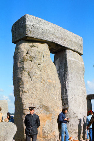
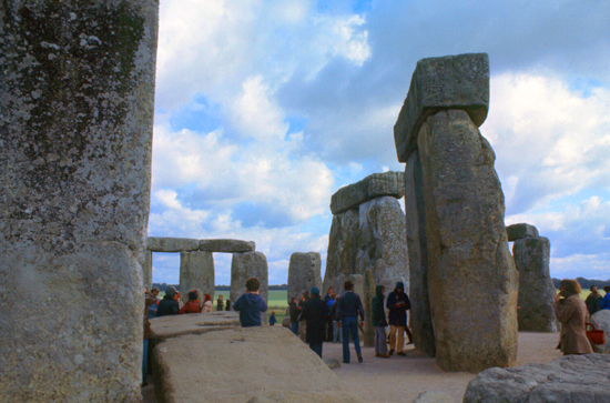
I took the picture at left just before departing, and it can perhaps serve as an anchor for my comments on what I found here. I did learn that the site, specifically the great trilithon, the encompassing horseshoe arrangement of the five central trilithons, the heel stone, and the embanked avenue, are aligned to the sunset of the winter solstice and the opposing sunrise of the summer solstice. The excavated remains of culled animal bones suggest that people may have gathered at the site for the winter solstice, which makes me think of the Mayan tradition that the world will come to an end on the winter solstice in 2012. But further astronomical associations, and the precise astronomical significance of the site for its people, are a matter of speculation and debate.
Aside from the significance of the site, a question just as big is how the site was constructed at all. There is little or no direct evidence revealing the construction techniques used by the Stonehenge builders. Over the years, various authors have suggested that supernatural or anachronistic methods were used, although numerous demonstrations have been constructed to show how available techniques might have been used. Even so, how the stones could be transported by a prehistoric people without the aid of the wheel or a pulley system is not precisely known. Proposed functions for the site include usage as an astronomical observatory or as a religious site.
To me, a large part of the attraction of Stonehenge is that there is still mystery surrounding it. I know that archaeologists and antiquarians are hard at work trying to explain it all, but somehow, I hope they never do. I think that future generations should be able to come here, marvel at what they see, and feel some connection to their ancient forebears. I worry that should it all be explained, this connection will be harder (if not impossible) to form. And to me, that's what Stonehenge is- connection. Connection to our past and, by implication, connection to our future.
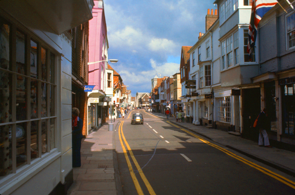
In the Town of Salisbury
|
The name Salisbury, is first recorded around the year 900 as Searoburg, but was a partial translation of the Roman Celtic name Sorviodunum- implying a "fort of Celtics". Originally called "Sarum", the city had two distinct periods in its history- Old Sarum and New Sarum.
The hilltop at Old Sarum lies near the Neolithic sites of Stonehenge and Avebury and shows some signs of early settlement as trade routes and rivers converged hee. A hill fort dates to around 500 BC, and the Romans may have occupied the site for a time. Old Sarum fell to King Cynric of Wessex in 552. The settlement was a backwater until the Viking invasions in the late 800s. Over a century later, it was sacked and burned by the Danish. Following the Norman invasion of 1066, a castle was constructed here. In 1075 the first bishopric of Salisbury was created, the construction of the first Salisbury cathedral begun; the cathedral was consecrated in 1092.
Conflict between the bishop and the king led to conflict, the cathedral was eventually moved to a new town on the estate of one Richard Poore at Veteres Sarisberias in 1220, and this town became New Sarum. Work on the new cathedral building, the present Salisbury Cathedral, began in 1221 with royal approval. New Sarum was made a city by a charter from King Henry III in 1227 and, by the 14th century, was the largest settlement in Wiltshire. The city (which had five gates) wall surrounds the Close and was built in the 14th century, again with stones removed from the former cathedral at Old Sarum, that site falling into disuse.
|
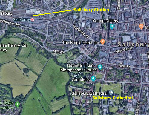
At right you an see an aerial view of much of the town of Salisbury. I've marked the train station in the upper left, and the Salisbury Cathedral, the furthest point of my walk, in the lower right.
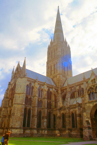
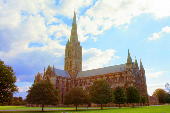
I definitely wanted to see Salisbury's Cathedral; we had actually studied his history and architecture in Humanities when I was in college ten years ago, so I made my way in that direction.
|
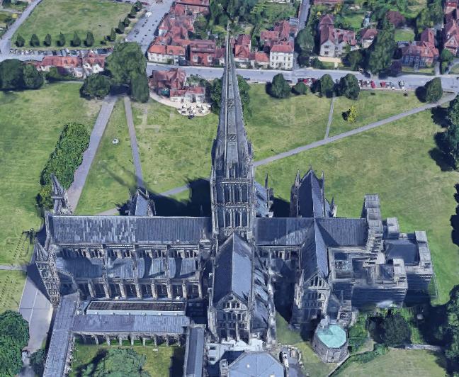
Since 1549, the cathedral has had the tallest church spire in the United Kingdom, at 404 feet. Visitors can take the "Tower Tour", in which the interior of the hollow spire, with its ancient wooden scaffolding, can be viewed. The cathedral has the largest cloister and the largest cathedral close in Britain at 80 acres. It contains a clock which is among the oldest working examples in the world, and one of the four surviving original copies of the 13th-century Magna Carta. The cathedral is the mother church of the Diocese of Salisbury and is the seat of the Bishop of Salisbury.
As a response to deteriorating relations between the clergy and the military at Old Sarum Cathedral, the decision was taken to re-site the cathedral, with the seat of the bishopric being moved to New Sarum, or Salisbury. The move occurred during the tenure of Richard Poore, a rich man who gave the land on which the new cathedral was built.
|
The foundation stone was laid on 28 April 1220. As a result of the high water table on the new site, the cathedral was built on foundations only 4 feet deep, and by 1258 the nave, transepts, and choir were complete. The only major sections begun later were the cloisters, added in 1240, the chapter house in 1263, the tower and spire, which dominated the skyline from 1320. Because most of the cathedral was built in only 38 years, it has a single consistent architectural style, Early English Gothic. In total, 70,000 tons of stone, 3,000 tons of timber and 450 tons of lead were used in the construction of the cathedral.
Although the spire is the cathedral's most impressive feature, it has proved troublesome. Together with the tower, it added 6,397 tons to the weight of the building. Without the addition of buttresses, bracing arches and anchor irons over the succeeding centuries, it would have suffered the fate of spires on other great ecclesiastical buildings and fallen down; instead, Salisbury became the tallest church spire in the country (when the spire on a church at Lincoln, England, collapsed in 1549). The large supporting pillars at the corners of the spire are seen to bend inwards under the stress. The addition of reinforcing tie-beams above the crossing, designed by Christopher Wren in 1668, halted further deformation. The beams were hidden by a false ceiling installed below the lantern stage of the tower.
Significant changes to the cathedral were made by the architect James Wyatt in 1790, including the replacement of the original rood screen and demolition of a bell tower which stood about 320 feet northwest of the main building. Salisbury is one of only three English cathedrals to lack a ring of bells, the others being Norwich Cathedral and Ely Cathedral. However, its medieval clock does strike the time with bells every 15 minutes.
|
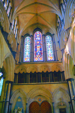
The west front is of the screen-type, clearly deriving from that at Wells, England. It is composed of a stair turret at each extremity, with two niched buttresses nearer the centre line supporting the large central triple window. The stair turrets are topped with spirelets, and the central section is topped by a gable which contains four lancet windows topped by two round quatrefoil windows surmounted by a mandorla containing Christ in Majesty. At ground level there is a principal door flanked by two smaller doors. The whole is highly decorated with quatrefoil motifs, columns, trefoil motifs and bands of diapering.
The west front was almost certainly constructed at the same time as the cathedral. This is apparent from the way in which the windows coincide with the interior spaces. The entire facade is about 108 feet high and wide. It has been said that the front was built on a scale smaller than was initially planned. It lacks full-scale towers and/or spires as can be seen, for example at Wells, Lincoln, Lichfield, etc. The facade was disparaged by Alec Clifton-Taylor, who considered it the least successful of the English screen facades and a travesty of its prototype (Wells). He found the composition to be uncoordinated, and the Victorian statuary "poor and insipid".
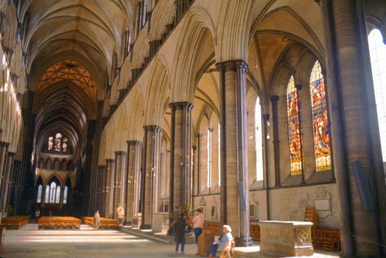
The front accommodates over 130 shallow niches of varying sizes, 73 of which contain a statue. The line of niches extends round the turrets to the north, south and east faces. There are five levels of niches (not including the mandorla) which show, from the top, angels and archangels, Old Testament patriarchs, apostles and evangelists, martyrs, doctors and philosophers and, on the lower level, royalty, priests and worthy people connected with the cathedral. The majority of the statues were placed during the middle of the 19th century, however seven are from the 14th century and several have been installed within the last decade.
|
Lined up between the pillars are notable tombs such as that of William Longespée, half brother of King John and the illegitimate son of Henry II, who was the first person to be buried in the cathedral.
|
The chapter house, attached to the south side of the cathedral, is notable for its octagonal shape, slender central pillar and decorative medieval frieze. It was redecorated in 1855-9 by William Burges. The frieze circles the interior above the stalls and depicts scenes and stories from the books of Genesis and Exodus, including Adam and Eve, Noah, the Tower of Babel, and Abraham, Isaac and Jacob.
The chapter house also displays the best-preserved of the four surviving original copies of Magna Carta. This copy came to Salisbury because Elias of Dereham, who was present at Runnymede in 1215, was given the task of distributing some of the original copies. Elias later became a canon of Salisbury and supervised the construction of the cathedral. Of course, I went inside the chapter house to see the copy, which was under heavy glass and reminded me of the National Archives in Washington and its display of the Constitution and Declaration of Independence. Photography wasn't allowed, but I doubt that a picture withough flash would have turned out well in any event.
The cathedral was quite beautiful, and I would have stayed longer, but I thought I should get back to the station in plenty of time for my train. I got back to London about eight o'clock, had some dinner and retired. A day later I was on my return flight home to Chicago.
|
Return to the Index Map for My Trip to England |