|
June 2, 1996: Our Adventures in Dog Canyon |
|
Return to the Index for Our New Mexico Trip |
We planned our early summer trip for May 31 through June 4. Our trip started out as uneventful as any of the many others we have taken. As usual, Fred did most of the planning, and it was he who had to stay up until all hours on Thursday night to get all the camping gear together, pack, and load his truck- so he could leave directly from work and head down to Dallas. Fred is always the one who plans the camping menus, lays in the initial supply of food, and packs everything the night before. He really puts in a lot of effort in that.
Getting to Midland (May 31)
|
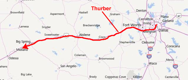
Our route would take us through Thurber, a short ways beyond which is the turnoff Fred takes to Deleon when he goes to visit with his mother. We would continue on through Abilene and Sweetwater and Big Spring heading on towards Midland and beyond. On these trips out west, we try to get as far as we can before we stop for the night; usually that means Midland/Odessa.
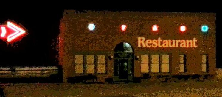
In Thurber, we rejoiced in our good fortune that for once we had made it to the Smokestack Restaurant (a relic of the old company-town days when Thurber was one of the West's brickmaking capitals) before it closed. The restaurant advertises itself as "The only place to eat in downtown Thurber for over 35 years", which is technically true. Downtown Thurber, such as it is, Thurber being pretty much a shadow of its former self, is on the right side of I-20. On the left side, up a hill, there is actually another restaurant that we have patronized, but it is not in "downtown Thurber".
|
But we weren't, and so we didn't; we just got back in the truck (whose stamina would be sorely tested in the days to come), and continued west.
It was my turn to drive on the leg to Midland and our hopeful stopping point, and for a while the drive was uneventful, until I got a bit sleepy, and Fred took over for a while so I could close my eyes. Then, after some further miles, I got back in the driver's seat for the last 60 miles to Midland.
|
So it was all the more jolting when I finally did notice the flashing red and blue lights in my rearview mirror. (Maybe I should have noticed that the speed limit was 70MPH only up until dark- and then dropped to sixty-five.)
Anyway, that failure of awareness netted me a few bits of official looking paper ("Now you need to sign here, but you aren't admitting guilt by doing so." and "Here's all the information you need to contact the JP in Big Spring by mail and y�all have a nice night."). It also resulted in a fairly hefty contribution to the coffers of Howard County.
That experience woke me up, so to speak, and it was with some relief that we eventually reached the Super 8 Motel in Midland.
Getting to Sitting Bull Falls (June 1)
|
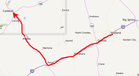
We got to Carlsbad, stopped for gas, supplies, and various pieces of ceramic, and then headed north on US Highway 285 towards Roswell.
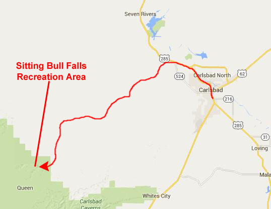
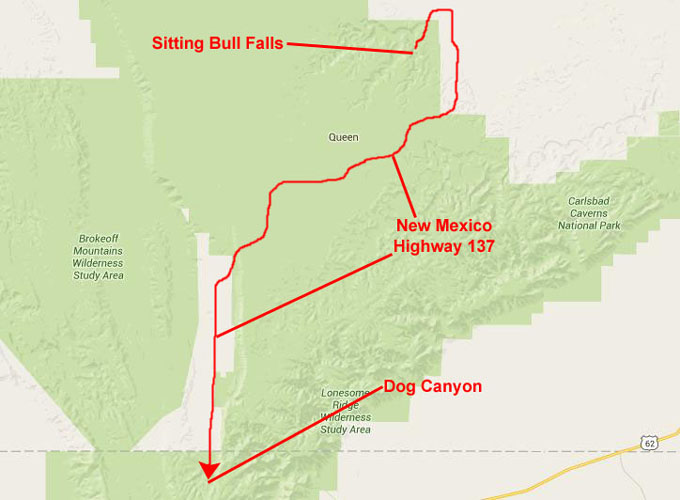
In looking at our maps the week before, we realized that Sitting Bull Falls would be one of the more out-of-the-way places we have been in quite some time. About the only way to get there was to turn off US 285 on a County Road to get to the Sitting Bull Falls Recreation Area.
|
Sitting Bull Falls is a series of waterfalls located in a canyon here in the Lincoln National Forest. This popular recreation area is maintained by the United States Department of Agriculture's Forest Service
Sitting Bull, a Dakota Sioux from the northern Great Plains, probably never set foot in New Mexico. But a much-repeated legend claims that that cowboys chased a group of Indians that included the old chief into Sitting Bull Canyon and thereby discovered the falls. Unfortunately for the story, Sitting Bull was in Canada in 1881, the year of the reputed discovery.
An equally improbable explanation tells of early Eddy County resident, Bill Jones, spinning tales of the old days in the Guadalupes. His description of the falls was met with derisive comments from his brothers, who called it "pure bull." "Well, Sitting Bull," suggested one brother, "if those falls are really there, we'll name them after you!"
Regardless of how the falls were discovered, they are indeed a gem in this part of New Mexico which, as our drive here disclosed, is most arid, uninteresting scrubland. Even within the National Forest, water sources are rare, which is why this area is so popular.
Hiking Around Sitting Bull Falls
|
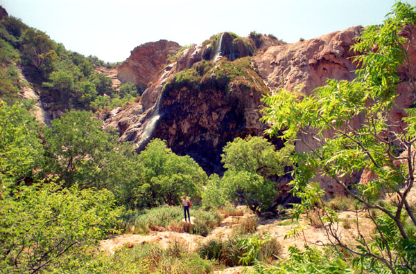
The falls are fed by springs located in the canyon above. The water flows through a series of streams and pools until reaching the falls where it drops 150 feet into the canyon below. Most of the water disappears into the gravel or cracks in the rocks and either reappears in springs further down the canyon or joins the Pecos Valley underground water supply.
The area around Sitting Bull Falls is the remnant of a reef system known as the Capitan Great Barrier Reef dating from the Permian period. Approximately 250 million years ago, the region was located near the edge of an inland sea.
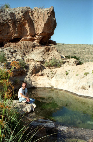
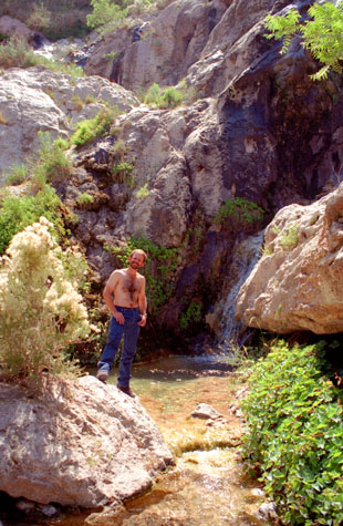
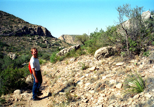
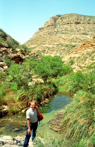 Fred in the Canyon Below the Falls |
(Picture at left) There is quite a contrast between the vegetation in the canyon and the land around it. The presence of water makes all the difference. The mountain behind Fred is more typical of the scenery around here where there is little water- and that is most of the time. The vegetation here was much like an oasis.
(Picture at right)
|
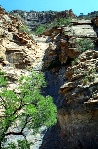 A View Up the Mountainside |
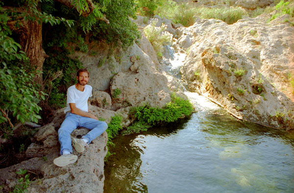
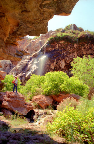 At the Base of Sitting Bull Falls |
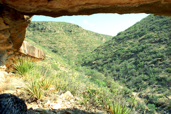
(Picture at left) I think this will give you some idea of the size of the falls. They are not particularly tall, nor is there a large amount of water going over them. I think the attraction is simply that they are here at all. I am standing under a rock overhang on the side of the canyon opposite the falls. This was the only place anywhere around here where we found trees like these.
(Picture at right)
|
 At the Base of Sitting Bull Falls |
In addition to the pictures we took with our regular cameras, Fred had brought his panoramic camera along, and he used it twice to take vertical panoramas here at the falls. These pictures, of course, are extremely tall, and if I size them down to fit on the screen, most of the detail is lost. So I have put the two of them in scrollable windows below, so that you can see the detail Fred captured:
|
|
|
Whatever legend you want to accept about the naming of the falls, one thing that is known is the Apache name for the area- "gosta hana gunti"- which means "hidden gulch". We took some more pictures around the base of the falls before hiking up.
|
Next, Fred, who had been here before, led an expedition up behind the falls to a cave he knew about. We had to climb up through the falls, there being no way around, so we did get a bit wet, but the cave was worth it. The cave had a number of pools of water (some of them fairly deep) and some actual formations (not real pretty, since so many people climb up here and put their hands all over them). (Actually, in the years since our visit, access to the caves has required a permit.)
I guess that getting wet would classify as a bad thing, but then it was so warm that it actually felt good. However, when Fred hit his head on one of the ceiling formations while stepping across a pool of water, that was definitely a bad thing. It was just a glancing blow, though, and Fred cautioned me against doing the same thing when I followed in his footsteps.
Needless to say, I did exactly the same thing, but with a lot more force than Fred. The blood concerned me some, but it should stop after a while.
Outside the cave, Fred found a very pretty sotol cactus, and he wanted to photograph it. It was odd that Fred took a picture of this particular type of cactus here, for it (the type, not the actual cactus) was to play a major role in the events of tomorrow, although we didn't know that at the time.
My head has stopped bleeding, and the headaches have pretty much tapered off, but they were of concern at the time, too. I can't quite shake Shirley MacLaine's voice, though, and I seem to be remembering more past lives than usual, but I guess that will clear up eventually.
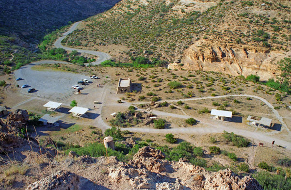
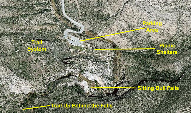
A paved path connects the picnic area to the area around the bottom of the falls where wading and swimming are allowed and where we took our first pictures. There are also a number of hiking trails allow visitors access to the springs above the falls, and that's where we headed next. You can see some of these trails in this interesting aerial view of the Sitting Bull Falls Area:
 |
In 1940, the Civilian Conservation Corps constructed a number of stone buildings which are part of the parking and picnic area. A time capsule located in front of one of the buildings was dedicated on March 24, 1999 and will be opened on the 100th anniversary of the Civilian Conservation Corps' construction in the area.
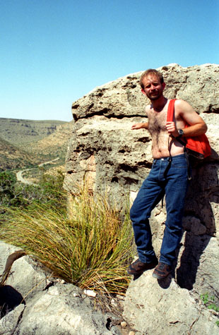 Above Sitting Bull Falls |
(Picture at left) After the falls, we took a hike up on the plateau above them for a couple of hours. We hiked quite a ways back up into the mountains to the source of the stream that becomes the falls. There was lots of interesting vegetation and many intriguing rock formations. Here, you can see the road coming into the Sitting Bull Falls area, and you can also see that we have climbed up basically to the top of the plateau.
(Picture at right)
|
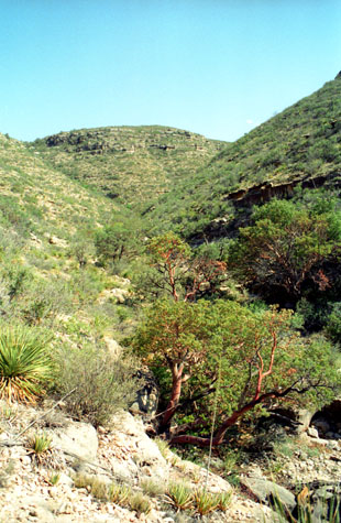 Above and Behind Sitting Bull Falls |
We continued hiking up the hillside; it was a beautiful day and, although it was a little warm, we were able to take our shirts off which made it very, very pleasant. It seemed that every time we turnd a corner in the trail, some new vista opened up that seemed to deserve a photograph.
|
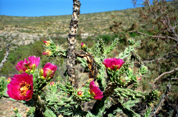
As we walked along, I got a number of good pictures, such as this one of Fred on the hiking trail. If it doesn't seem as if all these pictures are really memorable, it is because I was worried that I had not loaded film correctly in the camera. The counter had passed 38, and I was using 36-exposure rolls. The last time it did that, last Christmas up at Fred's house (see this year's Miscellaneous Pictures), I opened the camera and found that I had no film. I wanted to find that out before we got away from the falls so that I could remedy the problem if indeed there was no film or it had not caught in the sprockets when I loaded it.
Fortunately, the problem resolved itself after my very next picture as I finally came to the end of the roll. Below are the last picture I took of Fred on the trail as well as a picture of some flowering cactus that Fred took while I was changing film:
 |
 |
I was no longer actually trying to use up film, but along the way I thought this gnarled tree was an interesting backdrop, so I had Fred use my camera to take this shot. Although it is arid and forbidding, the landscape in this part of the country has its own severe beauty. The hills and rocks just seem to call our for hikers and climbers. I would have liked to have hiked over across the stream and up those hills opposite, just to see what the view would be like from the top. But we had places to go and things to do, so I didn't. Another time, perhaps.
|
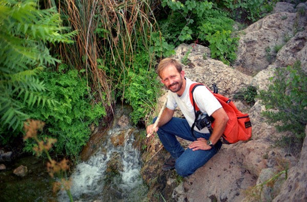
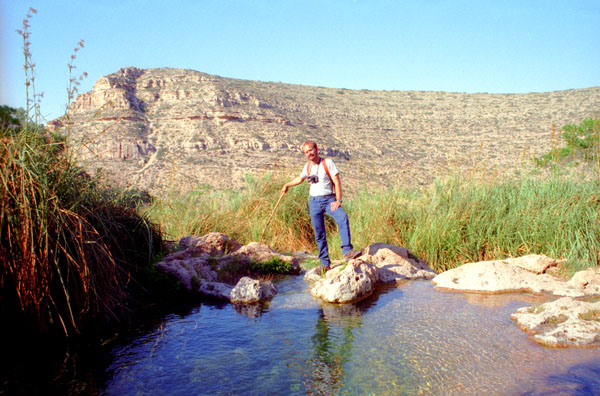
Hiking down here by the stream (see picture at left) was entirely different than hiking the high route we had taken earlier. There was lots of vegetation, and there was always the water and the sounds it made as it tumbled downward over the rocks. There were lots of ferns, and a great many interesting plants and flowers. We took it slow so Fred could examine the ones that were interesting. We have both picked up walking sticks, and I still have them in the garage.
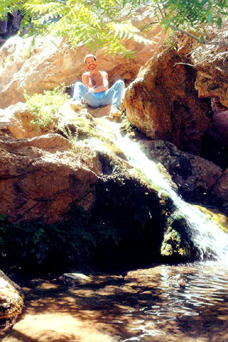
The stream itself had its own beauty, and this was one of the nicest spots along its course above the falls. I got a good picture of Fred at a small waterfall along this stream. The actual trail has disappeared, but we know the way; all we have to do is follow the downward course of the water and watch out for the place where it leaps out into empty space and becomes Sitting Bull Falls. Climbing downward over these rocks was easy but interesting, and the shade lent some welcome coolness to the day.
Fred got another interesting picture along this stream, that of me beside a small pool in the creek above Sitting Bull Falls. This was just one of many intriguing pools and rapids in the creek. The water was very inviting and actually quite cold. I was sorely tempted to drink it, but signs below at the parking area advised against it. Fred has gone for that starburst effect again, and achieved it.
|
|
This was a really interesting place, here at the top of the falls. There aren't many waterfalls we have been to where you can safely wander around on top. The ledge I lay down on seemed seemed almost too convenient, the rocks offered shade from the heat of the sun, and the water and waterfall were inviting. This would have been a wonderful place to camp, were it allowed and were we to have the stamina to lug all the camping stuff up here. Views, shade, running water- what more could you ask? There are another couple of pictures that I think I should include here:
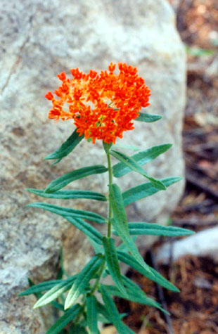 Flora at the Top of Sitting Bull Falls |
(Picture at left) If I knew just what this was that Fred took a picture of, I would tell you. All I know is that it is quite pretty.
(Picture at right)
|
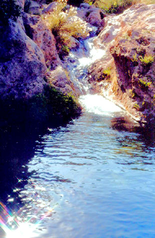 Cascade and Pool Above the Falls |
We, I guess, were fortunate in the timing of our visit. I have learned that the day use area here was closed a year or so ago because of a fire, and the area would be closed for almost a year because of a fire that would occur in 2011.
|
Notice the reeds growing at the exit from the pool. Walking around behind Fred was not dangerous, so long as you were careful not to step on anything but dry rock. Anywhere else, and you run the risk of slipping and sliding right over the edge. This is a neat shot because one would not expect there to be a canyon twenty feet behind Fred, especially not one as deep as the one that is actually there.
This was a great place, here at the top of the falls, but we wanted to head off to find Last Chance Canyon, and so we headed back on down to the parking area.
On the way down to the parking area, we passed an interesting cactus and Fred wanted to photograph it. He needed someone in the picture for reference, so that's why I am looking at the plant.
|
Back at the parking area, we began looking for the trail to Last Chance Canyon; one of the end points of that trail was, according to New Mexico Magazine, just outside the Sitting Bull Falls area, so we followed the magazine's directions as precisely as we could until it said "take the obvious foot path" and of course there was no obvious foot path in sight. We did follow one path that ended at a fenced area, and we didn't see any way around it. So we thought that perhaps the directions were a bit off, or we had misinterpreted them, and, due to the lateness of the day, decided to head to the campground in Dog Canyon, and then try the other set of directions on Sunday.
Getting to Dog Canyon, Texas
|
The first thing we did was to look for a campsite, and we found that there were some good ones still aailable (even though there were only six or eight of them there). We laid claim to one of them and the two of us put up the tent. Fred started dinner on his trusty stove while I inflated the air mattresses (manually, as usual) and got the inside of the tent in order.
When dinner was ready, Fred went to turn on his electronic lantern and found it wasn't charged up. That was only a minor inconvenience, as there was still plenty of light to see by. And we could charge the lantern in the truck as we drove the next day. After we got everything cleaned up, we just stayed up a little while waiting for the moon to come up, and then hit the hay.
You can use the links below to continue to another photo album page.
|
June 2, 1996: Our Adventures in Dog Canyon |
|
Return to the Index for Our New Mexico Trip |