|
July 20, 1997: Touring Jackson and Salt Lake City |
|
July 18, 1997: Mammoth Hot Springs and the Grand Canyon of the Yellowstone |
|
Return to the Index for Our Yellowstone Trip |
Today, we are going to do some hiking in Grand Teton National Park, the entrance to which is now only ten miles away from our new digs in Jackson, Wyoming.
Getting to the Inspiration Point Trailhead
|
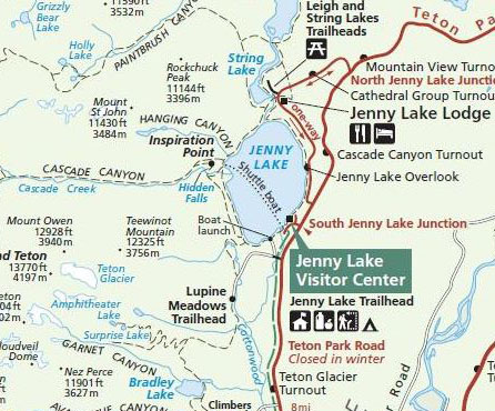
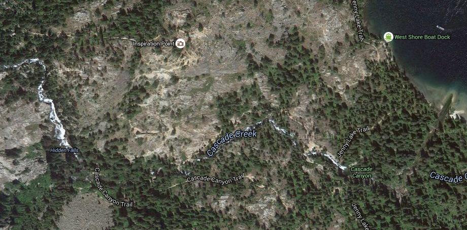
At Jenny Lake, we drove up to the Visitor Center for the lake and bought tickets on the Jenny Lake shuttle boat that goes from the visitor center across the lake to the northwest to the West Shore Boat Dock. Part scenic-tour, part water-taxi, the Jenny Lake shuttle is unique for the area. The ferry (actually not a ferry as you might imagine it, but rather a large motor boat that can carry about 10 people) departs from South Jenny Lake roughly every fifteen minutes, and one of them carried us across the water to the Cascade Canyon trailhead. That would be the jumping off point for our hikes to Cascade Canyon, Hidden Falls, Inspiration Point and a scramble cross-country up the slopes of Mt. St. John.
It was a nice drive up the highway from our motel to the park, although this was Saturday, and there was noticeably more traffic than there had been yesterday or the day before. I am glad we have finished with Yellowstone, because I imagine that on weekends in the summer it is pretty much stop-and-go all along the Park Road.
|
The lake is estimated to be 423 feet deep and encompasses 1,191 acres. Jenny Lake is considered to be a major focal point in Grand Teton National Park, with many hiking trails, scenic boat rides, and quick access to the major climbing routes onto the tallest peaks of the Teton Range.
Jenny and Jackson Lakes are the only lakes in Grand Teton National Park where motorboats are permitted. Even so, a 2005 study of the water quality of the lakes in Grand Teton National Park indicated that all the lakes in the park were still considered pristine and that they had not been impacted by air or water pollution.
Jenny Lake is a starting point for many day and overnight hiking trips. The 7.1-mile Jenny Lake Trail loops around the lake and is considered to be relatively easy due to the small altitude gain of 700 feet. However, the altitude increases rapidly once Cascade Canyon is entered.
Jenny Lake is named after a Shoshone Indian woman who married an Englishman, Richard "Beaver Dick" Leigh; Jenny was the English name by which she was known. There is another lake nearby named for Richard Leigh. Sadly, tragedy struck the Leigh family when a smallpox epidemic swept through the area in 1876; Jenny and all six of the Leigh children died.
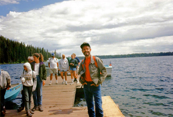
We did not have to wait long for the next shuttle, even though the one just ahead of ours was already spoken for. I think the wait was about 25 minutes before we were on the boat and heading out.
|
Rocky Mountain scenery offers dramatic vistas but few more impressive than the Teton skyline. As the Teton Range rose through sporadic earthquake-producing jolts, the valley called Jackson Hole subsided. Because of the way the mountains formed, no foothills hide jagged peaks and broad canyons. At the base of the range, large lakes mirror the mountains on calm summer days, doubling their prominence.
During the immense span of time before the mountains' rise, vast seas repeatedly advanced and retreated, leaving behind a thick, nearly flat blanket of sedimentary rock layers. Between 60 and 70 million years ago ancestral mountains rose here as a broad, northwest-trending arch, and the last seas retreated eastward.
Jackson Hole east of the arch became the site of enormous sheets of gravel interspersed with thick volcanic ash, lava, and freshwater lake sediments. Enormous tensional faults fractured these formations, and 9 million years ago today's Teton Range started rising.
Broken sedimentary layers of ancient sandstone, shale, dolomite, and limestone still cap each end and the western side of the range. The sandstone remnant atop Mount Moran, over 6,000 feet above the valley, once connected to the same sandstone layer that now lies an estimated 24,000 feet below the valley floor block resulting from the faulting process that created these mountains.
|
Continuing the story of the creation of the Tetons, in addition to the great displacement along the Teton fault (see above), the central peaks were thrust even higher, along fault zones within the range. Wind, water, ice, and glaciers long ago stripped sedimentary layers off the central peaks, uncovering basement rock nearly as old as the Earth itself. Resistant granite, sculpted into the Grand Teton and adjacent peaks, towers as the central range's exposed core.
Two rectangular blocks of the Earth's crust moved like giant trap doors, one swinging skyward to form the mountains, the other hinging downward to create the valley. Wind, rain, ice, and glaciers constantly eroded the rising range. Meanwhile, enormous glaciers and torrential meltwaters flowed southward carrying cobbles, gravel, and coarse sand and periodically releveled the floor of the sinking valley.
The Hike to Inspiration Point
 |
From the boat dock the trail began climbing upward through a pristine conifer forest. Although we didn't know it at the time, the first stretch of the trail has quite a few patches of huckleberry- one of the favorite foods of local bears. Luckily or unluckily, we didn't see any, although we learned later they can be a common sight at certain times of the year.
|
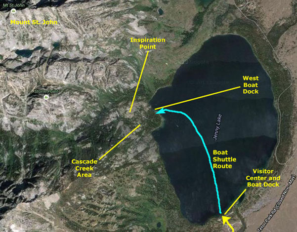
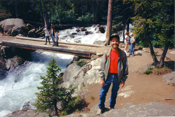
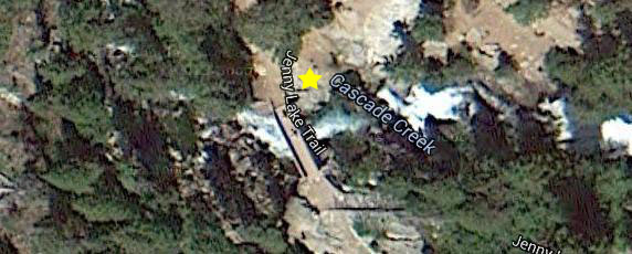
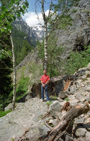
In the picture at left, I am standing approximately where the yellow star is on the aerial view below:
 |
We began following Cascade Canyon Creek after we passed the junction with the Valley Trail- about a half-mile from the lake; there was also a horse trail leading up from the lake and a sign telling to go straight through the junction with it.
|
|
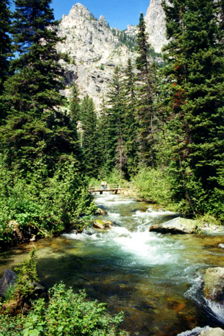
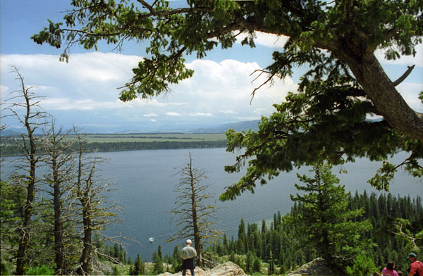
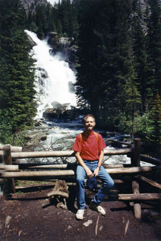
The trail was pretty easy, but what really made it spectacular were the views of Cascade Creek- views like the one at right. Of course, everywhere that Fred and I have traveled we have tried to arrange frequent hikes along water courses or to waterfalls.
In addition to Cascade Canyon Creek, there is a nearby spot called Hidden Falls, and there is supposedly a short side trail to go see it, so we have added it to our list. And of course, we are on our way to Inspiration Point.
The last few days have also made me realize once again what a great job the National Park Service does in taking care of the natural areas that have been set aside for everyone's enjoyment. I know we pay an entrance fee, and sometimes it seems a bit steep, but when it pays for trail improvements such as the bridges across Cascade Canyon Creek, it’s well worth it.
 At Hidden Falls |
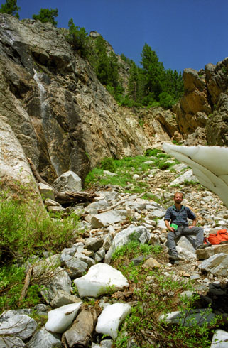
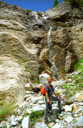
After a little while, we came to the short side trail that led to Hidden Falls. Since we weren't with a group or anything, we pealed off from the main trail to hike the short half-mile to the falls. The half-mile trail to Hidden Falls ended here- at the falls themselves. We’ve actually come quite a ways back into this canyon west of Jenny Lake, but the view of the falls here has been well worth it. Cascade Creek is glacier-fed, and extends only another couple of miles up into the Grand Teton Range. As advertised, the water was clear and cold. Unfortunately, we couldn’t get much closer to the falls, although we did spend some time wandering around here and just taking it all in. It’s gotten a bit warmer, as evidenced by the fact that I’ve temporarily shed my jacket. Ice, in the form of glaciers, created the Teton landscape and cascading water, like that at Hidden Falls, continually transforms it. Cascading water initially cut steep, V-shaped gorges throughout the rising Teton range. Glaciers, in sizes beyond imagination, advanced and receded in mountain gorges and across the floor of Jackson Hole. These glaciers widened steep gorges into broad, U-shaped canyons; cascading water is once again creating features like Hidden Falls, where the water drops roughly two hundred feet in a series of multiple steps. After spending some time at these beautiful falls, Fred and I returned to the main trail and turned left up the slope again to continue on towards Inspiration Point. From here, most of the trail was rocky and quite rugged.
|
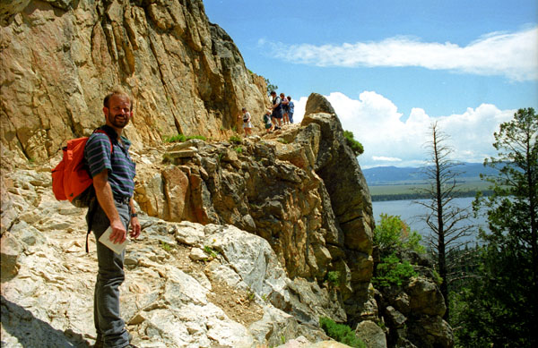
 The Rugged Rocky Trail |
Once again, I should say how enjoyable it was to hike up this trail. The day was almost perfect; perhaps only a few degrees too warm as it progressed. There were enough people around to provide scale, but not so many as to be intrusive. And the scenery- well, the scenery was nothing short of spectacular.
|
With the exertion and the sunshine, it has gotten quite warm now, and the jeans that were so comfortable in the cool of the morning are a bit too much now.
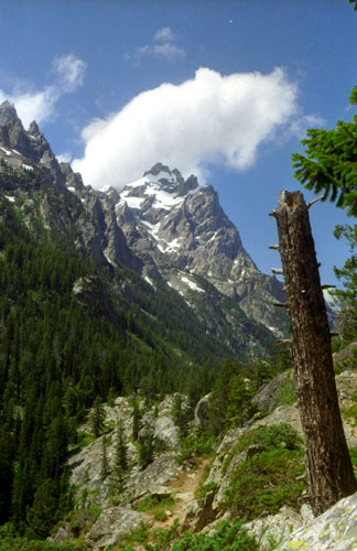
As you climb higher you'll enjoy some outstanding views of the "Cathedral Group" towering above the canyon towards the west. This group includes 12,325-foot Teewinot Mountain, 13,770-foot Grand Teton and 12,928-foot Mt. Owen.
|
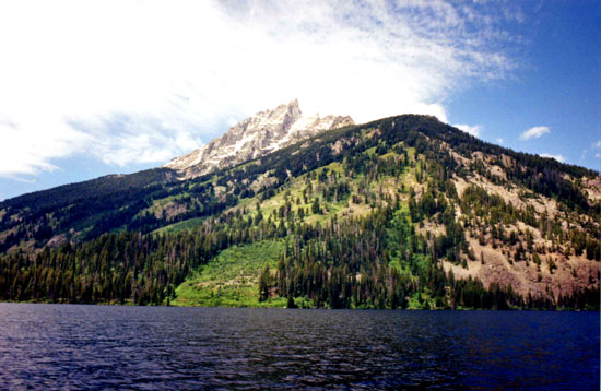
Inspiration Point is essentially a large rock outcropping overlooking Jenny Lake. I believe that this shot, which I took from slightly below on the boulders, looks almost due west, and so that would be Mount Moran in the background, with its complement of glaciers.
Over a comparatively short span of time, mountain glaciers of the last major glacial period shaped the Teton skyline more than any other erosional force. At upper elevations, where the most snow accumulated, the heads of the glaciers scooped out depressions, and frost wedging augmented their quarrying action. Sheer cirque walls, rugged ridges, and jagged peaks reflect the slow, dynamic carving by these great masses of moving ice.
One of the odd things about Inspiration Point was the number of chipmunks that were running around. They were apparently quite used to people, as they’d come right up next to you and beg for a handout. You couldn’t touch them, but they weren’t concerned if you were moving around or just sitting there.
|
My estimate is that we’ve climbed a few hundred feet to get to this point. You can see the boat shuttle coming in to dock at the West Dock way down below.
Jenny Lake, and the other lakes to the east and south, were created when rocks of all sizes, falling onto and plucked by the moving glaciers, increased their grinding power. The flanks of the range display scoured canyons that dive toward the valley. Upon leaving confining canyons, the larger glaciers spread onto the valley floor, while melting at a speed equal to their flow. An immense volume of unsorted rock, transported and dumped by these glaciers in a conveyor belt action, formed natural dams. These now encompass lakes called Leigh, Jenny, Taggart, Bradley, and Phelps. Similarly a lobe of the extensive Yellowstone snowcap extended southward as a broad glacier that deposited rock as morainal ridges, damming meltwaters to create Jackson Lake.
Hiking the Slopes of Mount St. John
|
|
Elevation gain beyond Inspiration Point was more gradual, and we followed a trail that led around the hillside and approximately the same level. As the trails began to be harder to follow, we were fortunate in that the sound of the falls began to lead us in the right direction.
It wasn’t perfect, for the sound echoed through some of the small canyons, but we eventually came out at a viewpoint from which we could look out over the falls themselves. This point was much nearer the top of Hidden Falls than we'd been to earlier. Right beside the falls, Fred took a nice picture of the Hidden Falls cascades.
We could see, further north along the cliff face that there was a mountain meadow and beyond that a small glacier that looked as if we could hike to it without too much trouble. In fact, there was a marked trail that led north along the sloping portion of Mount St. John, and we decided to follow that.
|
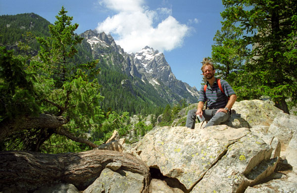
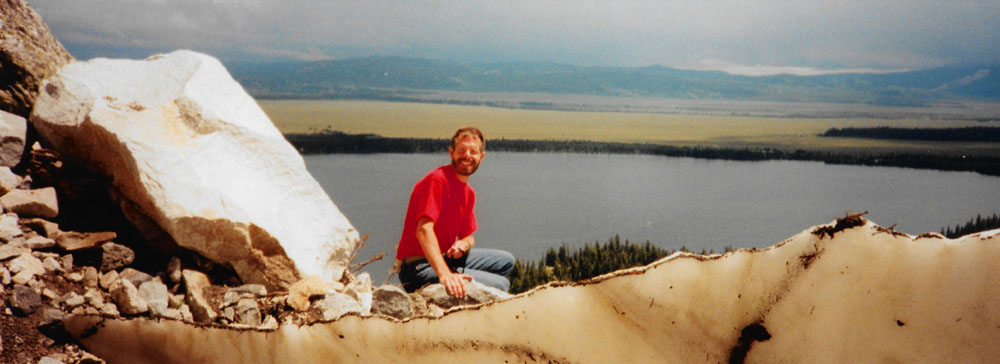
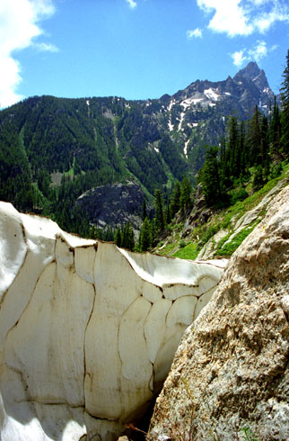
After quite a bit of cross-country hiking, we arrived at the small glacier, and in the picture at right I am standing beside part of it. Actually, it’s not really a glacier, but just some of the winter snowpack that has not yet melted. The snow was still pretty thick in spots, but I would guess that by the middle of August it would be all melted, if the temperature and the consistency of the snow now was any guide. Seeing snow is always interesting for a Dallas boy, and seeing snow in July is even more of a treat.
The weather was warm up here in the sunlight, and I guess I’m surprised that the snow has lasted this long. There must be a lot of it in the winter. I think the patters of dirt and soil on the snow are interesting, and I am not quite sure how they get there. The views from here were even better than from Inspiration Point, I thought. The snowpack added a lot with its contrast with the deep blue sky. P>
|
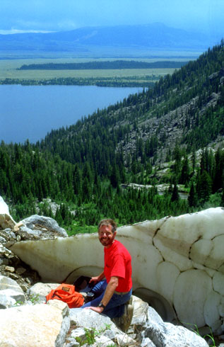
In addition to that vertical panoramic shot, Fred took a horizontal one with me, some of the melting snowfield and Jenny Lake; it is below:
 |
We took a number of other very good pictures from up here on the slopes, and you can see some of them below:
 View From Mt. St. John |
(Picture at left) Here’s a great view from the snow line. That’s Jenny Lake, of course, looking south along the eastern slopes of the Grand Teton Range. Inspiration point is at the extreme left of the picture, just over the hill crest that you see there. Hidden Falls is in the canyon in the center of the picture, but out of the picture to the right.
(Picture at right)
|
 Mt. St. John |
 Mt. St. John Cliff Face |
(Picture at left) Here’s another small waterfall and a bit of the snowpack. We spent quite a bit of time here. The views were tremendous, there was running water, and there was no one else around. It would have been interesting to try to climb up to the top of the cliff face, but we did not see any immediately apparent, short way up there, and we didn’t want to get caught over here if the weather got bad (though the skies are still blue just above us, clouds were moving in from the east).
(Picture at right)
|
 Fred on Mt. St. John |
We had seen a lot from up here, but with the clouds moving in, we thought we should begin to make our way back down to Inspiration Point and from there back down along Cascade Canyon Creek to the shore of Jenny Lake.
|
We picked up the Inspiration Point trail again and headed back down. Soon, we were back at Cascade Canyon Creek following it down the trail. One of our last views of the creek before we turned away to hike over to the boat dock is at left.
It is getting late in the afternoon now, and the sun is beginning to fade as the clouds thicken. We reached the boat dock, but had to wait a while while the people ahead of us took the shuttle back across the lake. Finally it was our turn, though, and we headed out. I don’t know whether it was the fact that the lake was choppier than it had been in the morning, or the clouds and kind of overcast weather, but by the time we reached the South Jenny Lake Visitor Center, Fred was distinctly nauseous (and I was just a bit so). I guess it was the combination of all these factors that conspired to make Fred feel really bad. It was all we could do to drive back to the motel and stretch out for a while. Actually, it took Fred a couple of hours to feel better, but eventually he did- at least enough to go into Jackson and have something to eat for dinner.
On the way into town, we saw signs for a museum- the National Museum of Wildlife Art, and so we headed up the short drive to it. It had closed at 5, but we were able to wander around just a bit outside. We planned to come back the next morning. It was just as well, because Fred really wasn’t feeling well yet. He did enjoy seeing the massive buffalo sculpture out front. We headed on into Jackson itself and wandered around for a while, had some dinner and made an early evening of it. Tomorrow was our trip back to Salt Lake City and the flight home.
You can use the links below to continue to another page for our Yellowstone Trip or return to the Yellowstone Trip Index page, from which you can go elsewhere in the photo album.
|
July 20, 1997: Touring Jackson and Salt Lake City |
|
July 18, 1997: Mammoth Hot Springs and the Grand Canyon of the Yellowstone |
|
Return to the Index for Our Yellowstone Trip |