A Bike Ride to Deerfield Beach
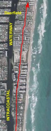
Today, Fred and I are going to take a rather ambitious bike ride. Our destination will be Deerfield Beach, some 17 miles from the condo up the Florida coast. Assuming we complete the trip, this will be a 35-mile ride when all is said and done. It won't be the farthest we have ridden, but it will certainly be a long trip.
We did not take many pictures along the way; these would duplicate pictures already in the album. But I do want to describe, perhaps in some detail, the route that we took. So, I am going to describe, with narrative and maps, how one bikes from my condo to Deerfield Beach, so you can get some appreciation not only for the length of the trip but for the sights we usually see on the way.
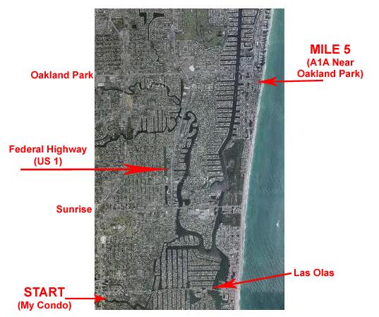
Mile 0 to Mile 5: My Condo to Oakland Park Blvd.
The first five miles of the bike ride took us over a route that both I and Fred have ridden more times than I can count. When we do go for a bike ride, we usually go all the way up the beach until A1A moves inland a block or so (to allow the construction of buildings right on the beach). We continue to stick as close to the beach as we can.
Just a bit south of the next major east-west street above Oakland Park, Commercial Avenue, we can get right back to the beach again, and we usually end the ride at an area called Lauderdale-by-the-Sea. It is located where Commercial Avenue ends right at the beach, and there are restaurants right on the beach where you can have breakfast or lunch. It makes a pleasant, but not strenuous, ride.
But first, the ride begins by getting from the condo to Las Olas Boulevard and then heading east:
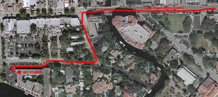
My unit is on the second floor in the building marked, in the position where the star is. So we just carry the bikes down one flight of outside stairs and we are ready to go. We go through the parking lot and then onto SE 4th Street heading east, turn on to SE 11th Avenue heading north, and then out onto Las Olas Boulevard going east. From this point, it is a straight shot along Las Olas to the beach. I've zoomed out a bit to show more of the route in the picture below. Once out on Las Olas, it is a block or two before we pass in front of the Floridian Restaurant (on the corner of the block in the lower left of this picture). This is a favorite place to eat; it has lots of local "color," has an extensive menu, and is open 24 hours. We'll often get a bite to eat there if we've taken a late flight down. Another block east and on the north side of the street is the Fort Lauderdale Hospital, one of the first in the city, which is now a "boutique" hospital catering to people in the immediate area. Then it's across one of the many canals in Fort Lauderdale and we are into the Las Olas Isles area.
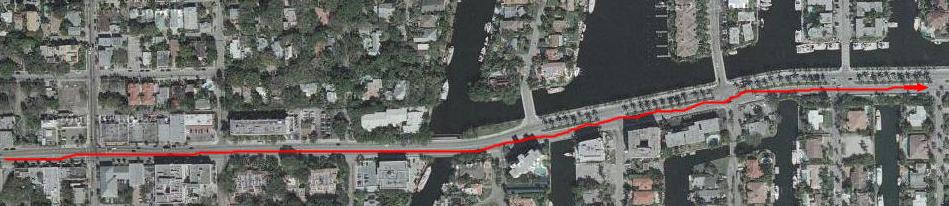
These islands are artificial, of course, and were built to take maximum advantage of the sheltered Intracoastal Waterway (which is still some distance east). The "fingers" on the north side of Las Olas are connected to the causeway by short bridges; the ones on the south are connected to the causeway directly. Each island is just a single street, with million-dollar homes lining the street on either side. On the northern islands, there are also a good many small apartment complexes; these look like very small motels, usually with just five or ten units. But, over the years, most of these are disappearing, replaced with larger homes.
Lining the canals on both sides, behind the homes, and around any water edge, are boat docks. Being the "Boating Capital of the World," Fort Lauderdale has more private boats than anywhere else, and they all have to be kept someplace. There are not nearly enough marinas for them, so every available foot of every single canalside is given over to docks. For the most part, the boats parked in the slips belong to the homeowners, but there is usually a good deal of additional space that landowners can rent out. Ty and Scott once lived on a boat they kept docked on one of the islands you see here. Rents for dock space range from $300/month for a small boat to more than $1000/month for a 50-footer kept in a desirable spot. There are canals and waterways all over Fort Lauderdale, and they are filled with boats. The larger boats must be kept in spaces that have unrestricted access to the Intracoastal ("no fixed bridges" is the term that is used in advertisements to denote these kinds of spaces). All of the spaces you see here are "no fixed bridges."
In the picture below (where I have zoomed out yet again), I've shown the route across the causeway. As you can see, there are many of these artificial islands, some north-south and some east-west, most of the connected to each other and/or Las Olas Boulevard. But alongside all of them, in every available space, are boats, boats and more boats. And this doesn't even count all the marinas spread over the area (where the REALLY big boats are docked)!
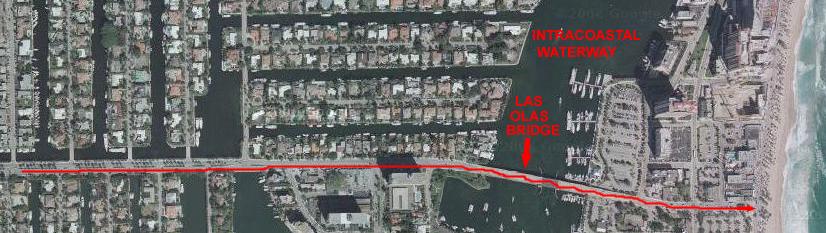
Technically, the entire beach area is an island, but it is a barrier island. There are bridges to it every so often north and south, and then inlets that cut through it once in a while. One of these inlets is south of us- Port Everglades and the Everglades Inlet. This is where the cruise ships go in and out and this particular inlet is large and deep. The next inlet north is at Hillsboro, and we will get there shortly. So to get to the beach, we must cross over the Las Olas Bridge, which is a drawbridge- like all the ones along the Intracoastal Waterway. Down the east side of the bridge we are at the beach. The last major street you cross before you run out of land is A1A/South. (A1A splits a ways north of here into southbound and northbound one-way streets, and they come back together south of here at Bahia Mar marina. Let's take a closer look at this area:
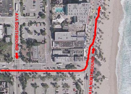 |
I've marked the southbound and northbound streets for A1A. For our ride north, we come all the way over to the beach, cross A1A and then ride along the wide promenade sidewalk up to Sebastian Street Beach. Although from the shadows this picture was taken in late morning, there are no people to speak of on the beach itself. Usually, there would be many people at the beach by this time, even in the off-season. The fact that there are almost none means that the picture must have been taken in January or February, and it must have been too chilly for very many people to want to lie out on the sand or go in the water. Anyway, we've crossed A1A and are now heading almost directly north.
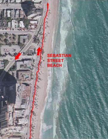 |
The wide promenade continues all the way up to the split of A1A at Sebastian Street Beach. As you go north, A1A is on your left and the decorative beach wall and beach are on your right. The trees you see here are actually planted within the promenade as well as along the beach wall. So it is usually shady here, although you do have to navigate around the trees and among the pedestrians. No fast riding here. But there is a bike lane on the street to your left, and if you are in a hurry that's the way to go. Fort Lauderdale has lots of streets with bike lanes, but I wish all the major streets did. On our route north, we will have bike lanes most of the way.
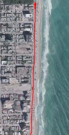 |
From Sebastian Beach, we simply continue north along A1A, as shown here in the map. Along this part of the route are some hotels and about three or four new condos and hotels under construction. Two of the taller buildings were not begun when this picture was taken; they are the two large, vacant lots you can see 1/3 and 2/3 of the way up the picture. As of this writing, however, the southernmost building is already more than half completed, and all the foundation and first couple of stories of the northernmost is complete. By the time I get down there next, I suspect they will both be quite far along. The green area where the development seems to stop abruptly is Bonnet House and Gardens.
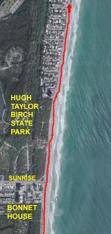 |
I have zoomed out yet again here, since the route continues directly north along A1A, now called Ocean Blvd., crossing Sunrise Blvd. The stretch you are looking at is a bit over a mile. You can see two large, undeveloped areas here- Bonnet House and Gardens on the south and the Hugh Taylor Birch State Park on the north. You've already seen pictures taken at Bonnet House earlier in this album, and on the album page for yesterday you saw some pictures of Hugh Taylor Birch State Park, so you already know a lot about these places.
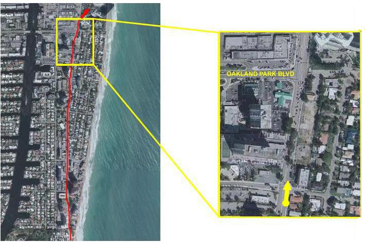 |
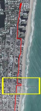
We continued biking north along A1A, eventually moving a bit away from the beach. Just a short way before reaching the next major street, Oakland Park Blvd., we reached the 5-mile point in the bike ride. To record this milestone, you can look at a picture we took at the point on the inset map marked by the yellow dot and looking in the direction of the yellow arrow if you will click
here
Then we continued north, crossing Oakland Park Blvd.
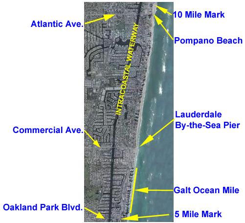
Miles 5-10: Oakland Park Blvd. to Pompano Beach
The second file miles of the ride were also covering ground that we have biked done frequently- pretty much more times than we can count.
From the area just south of Oakland Park Blvd., this five-mile section covers a ride along the condominiums on the Galt Ocean Mile, a short stretch along A1A, and then a jog back to the beach for the ride up to Lauderdale By-the-Sea.
From there, we continue north, back to A1A again, and then a long stretch up to Pompano Beach. Another jog over to the beach and we head north once more, with the segment ending just north of Atlantic Blvd.
Let's take a look at the ride in more detail.
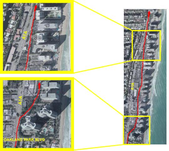 |
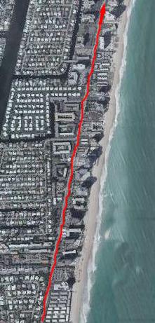
This section of the ride continues from the 5-mile mark a short distance further up A1A. This is probably the most dangerous section of the entire trip as for some reason there is no bike lane between the northernmost point of Fort Lauderdale Beach and the cut-in to Galt Ocean Drive. I don't know why there is no bike lane, but the four-lane, medianed road is fairly wide, and there is a sidewalk if the traffic is bad. In any event, the stretch is probably less than a mile.
As you can see in the first inset map at the right, just past Oakland Park Blvd. we can leave A1A and follow Galt Ocean Drive, which runs between the businesses than front A1A and the strip of high-rise condominiums than line the coast. This section does have a bike lane, is tree-shaded and usually free of much traffic at all. It is quite residential. This whole area is called the Galt Ocean Mile, and I think that all the condominiums along this stretch reach cooperative decisions on how the street should look. I usually see a fair number of private firms tending to the trees and plantings along the Galt Ocean Drive, and they seem to tend the entire street at once. After about a mile, Galt Ocean Drive rejoins A1A, and we lose the bike lane for just a bit. But it is only a short distance before we can turn off A1A again and get close to the beach once more.
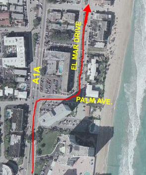 |
So, after we rejoin A1A, it is only three blocks before we reach Palm Avenue, where we can turn right and head towards the beach a short distance. Then we can turn left onto El Mar Drive and continue north. El Mar Drive is a very pleasant place to ride. Again, the street has a median, and there is very little traffic until you get to the circle where Commercial Avenue meets the beach. There are condos and hotels on your left (as you go north) and small hotels, timeshares and a couple of private residences on your right.
 |
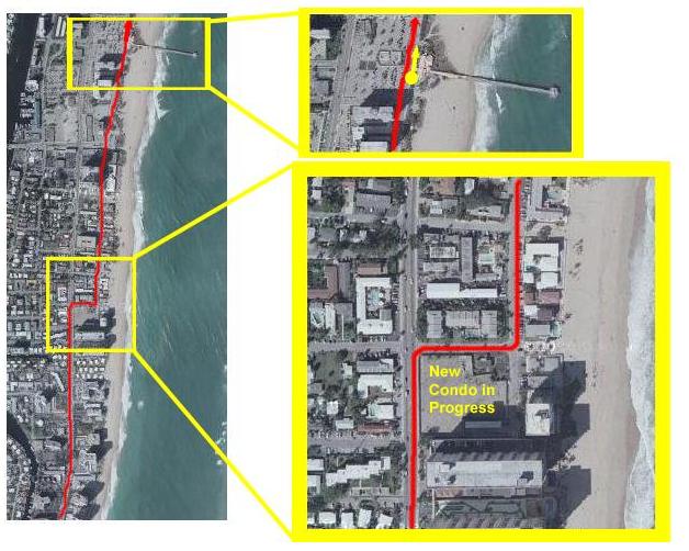
On El Mar Drive, we continue north about a half mile until we reach the point where Commercial Avenue, which is one of the main east-west streets, crosses over the Intracoastal Waterway, intersects with A1A and then continues on two blocks to the beach. Here, Commercial gains a median, and at El Mar Drive there is a circle. The whole area is done in pavestones. The central island is decorated for various holidays and events. At the beach, there's a water fountain and a place to sit, so I usually jog over and sit for a while. There are good restaurants here, and we've eaten at them more than once, and there is also a fishing pier. It makes for a really nice neighborhood area, and I am sure the condos that are going in will fetch quite a bit because of that. (You can see where some buildings have been cleared in the inset picture, just south of Commercial at the beach.)
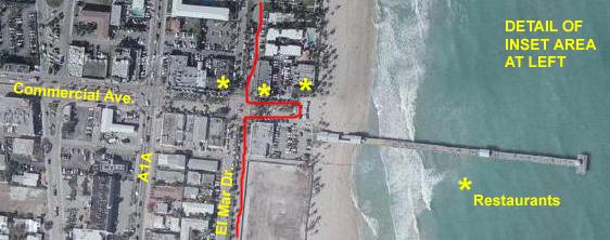 |
The bike ride continues up El Mar Drive, until it dead ends at a very large condominium building the occupies the area between A1A and the ocean.
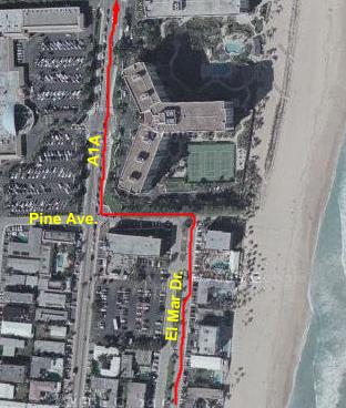 |
At Pine Avenue, there is a hotel complex on the beach called The Captain's Quarters. It has two buildings and a pool and bar area between them. It seems as if, no matter what time of year it is, the hotel is always busy, as evidenced by all the cars parked in front and in the large lot across the street. I imagine that it caters to snowbirds in the winter and vacationers in the summer, but it IS always busy. On the other side of El Mar, there is a regular hotel.
Right in front of you at the end of El Mar is a very large condominium. As you can see here, it has a pool AND tennis courts, and it is about fifteen stories tall. It is the southernmost of what is about two miles of one condominium or hotel after another between A1A and the beach. So once we hang a left on Pine Ave. and the a right on A1A (usually called Ocean Blvd. in whatever town it is going through), we will be on A1A for quite a while. Fortunately, we pick up a wide bike lane here, so even if there is a lot of traffic, the only thing we have to watch out for are people turning into or out of the condominiums and hotels.
This is another nice stopping place, because in the shopping center on the northwest corner of Pine Ave. and A1A there is a Baskin-Robbins store.
Now there is a long stretch up A1A than runs a straight shot from Lauderdale-by-the-Sea all the way to Pompano Beach. In the Lauderdale area, the major grid streets are about a mile apart, and this section runs between Commercial Blvd. and Atlantic Ave. The distance is actually two miles, because there is a major grid street, Copans Rd., that does not cross the Intracoastal and thus has no major intersection with A1A.
Along this part of the route there are, for the most part, condominiums and hotels between A1A and the beach. There are some new buildings being constructed in this area on the sites where older, low buildings have been demolished. On the west side of A1A, there are mostly residential neighborhoods- many with canals- that front on the Intracoastal. Right along A1A, they are condominiums rather than single-family homes. There is a bike lane here, so the riding is safe and easy.
To reach the 10-mile point in the trip, we continue up A1A, with mostly condos and hotels on both the left and right now, make a gentle dogleg to head more directly north, and then go another quarter-mile until we can head over towards the beach (as traced in the map at left).
The lower inset shows where we can make a right turn to again get close to the beach. Then we make a left turn to continue north on Briny Avenue, which runs right along the beach through Pompano.
This an older section of the Lauderdale area. The condos are older and smaller, for the most part, and there are a number of private residences on the beach south of Atlantic Avenue. At Atlantic Avenue, there is a parking area for the beach, and then north of that there are no private buildings between Briny Avenue and the ocean. This is the beginning of the area properly known as Pompano Beach. Over on A1A, there is a lot of development going on, with most of the land on both sides of A1A north of Atlantic being cleared for new condos or apartments. I think that the kind of picturesque, beach community vibe may be going by the wayside.
A few blocks north of Atlantic Avenue is the Pompano Beach pier, and it was very close to the pier that the 10-mile point was reached. There is picture
here
that was taken at the point marked by the yellow circle in the upper inset picture, looking in the direction the yellow arrow is pointing.
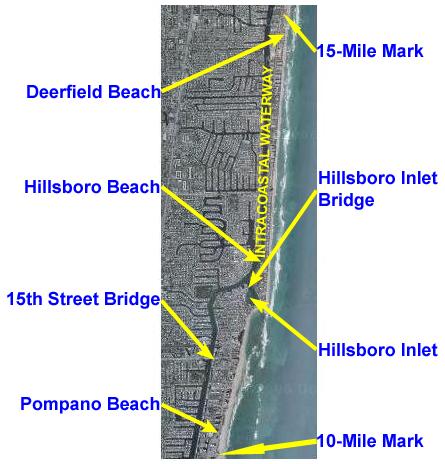
Miles 10-15: Pompano Beach to South Deerfield Beach
In this next section of the ride, we'll go from Pompano Beach north along A1A and then across the Hillsboro Inlet into the towns of Hillsboro Beach and Hillsboro. We'll continue north, eventually leaving Hillsboro and entering the southern part of Deerfield Beach. It is here that we will reach the 15-mile mark.
Along the way, there will be some excellent ocean views as well as a tour through one of the neighborhoods where the "other half" live. There will also be lunch.
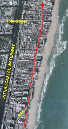
We begin our third five miles by continuing up Briny Avenue in Pompano Beach until it meets up again with A1A. There is no bike lane on Briny Avenue, but it is a wide street with little traffic. We pass by the Pompano Beach Pier and a couple of restaurants on the beach, and then get back on A1A.
The stretch up to 15th Street is not very long, and there is a bike lane, so traffic isn't a problem. Like many areas in South Florida, there is a lot of building going on here. In the last few blocks before 15th Street and for a block or two after, there is one condo project after another going up; a couple of them have signs declaring that the price range will be from "the high $900,000s" (which means that anything but a unit with no view will cost you upwards of $1 million). I suppose they'll be nice, but I don't know how they could be THAT nice.
15th Street is one of the major streets that cross the Intracoastal; so many people leave in the upper end of Pompano Beach and across the inlet in Hillsboro that there needs to be an evacuation route somewhere north of Atlantic Ave., and this is it.
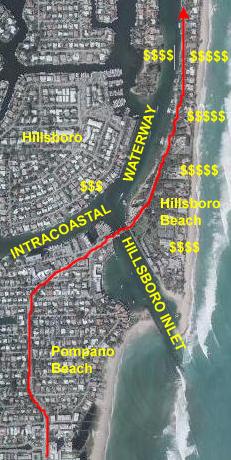
After crossing 15th Street, A1A continues north but then runs out of a more commercial area to wind through a residential one. A1A is a two-lane road by this point, but it still has a good bike lane on both sides. We are in the northern part of Pompano/Pompano Beach now. The road twists around a bit, and then takes a turn to the northeast to arrive at the Hillsboro Inlet.
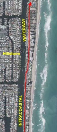
The Intracoastal Waterway wouldn't be what it is if there weren't outlets to the ocean every so often. Everglades Inlet, right in Fort Lauderdale, is one such outlet, and it serves the entire area from Hollywood up to Lauderdale-by-the-Sea. The next inlet heading north is this one, and every one from Pompano through Hillsboro and South Deerfield Beach uses it. (The next one north will be at Boca Raton.) Wherever you find these inlets, you will also find pricey real estate, because the people with the big boats don't want to have to go far to get out to the ocean.
At the drawbridge over the Hillsboro Inlet, there is a newly-renovated park and pier system on our right, and a couple of tall condos and some restaurants and shops on our left. Underneath the bridge and across the Intracoastal from where we are riding is the town of Hillsboro proper and, at least from what I can see of the houses lining the Intracoastal, it is a pretty exclusive place to live. There is always a lot of traffic going in and out here, so it is a good place to stop and take in the boating scenery.
Just before the bridge and on the west side of the street is a little breakfast and lunch place called
the Jukebox Diner,
and Fred and I stopped to get some lunch here. (Since this writing, the diner has closed, and I think that the area was going to be redeveloped. The project may or may not get off the ground, depending on how deep the housing recession gets in this particular area. As of June, 2008, nothing has happened on the site.)
Once you cross the bridge going north, you are in the town of Hillsboro Beach, and the homes here rival anything you might find in Biscayne Bay in Miami, Huntington Beach in California or Highland Park in Dallas, for that matter. The homes are all to your right, and, beginning very shortly into Hillsboro Beach, the lots run right across the island. As you are pedaling north along tree-shaded A1A, on your left you can see the large boat docks and boats that belong to the houses on your right. The houses are all very secluded for the most part, and only when there is a new one being built can you see what they look like, the foliage is so luxurious. If the town of Hillsboro gets three dollar signs, then this area must get five. A few years ago when I was biking along here, I noticed that there was a home lot for sale, so I took out my cell phone and called the Realtor. "It's really a prime piece of property," I was told, and "a steal" at $2.7 million. Gee, it's humbling to know that even if I could afford the lot, I certainly couldn't afford to put anything on it! The houses are all very, very nicely-done, as well they should be.
 |
 |
The houses get only slightly smaller as you go north and away from the Inlet. Finally, after going another mile, you begin to see condos again on your right. Most of them are only a few stories tall (no, those are not trailers), but they all seem very well done. As the barrier island widens a bit, there are some condo buildings on your left, too.
I hope you've noticed in all the pictures so far how built-up the area along the Intracoastal actually is. Just in the pictures you've seen so far, you've seen easily a few tens of thousands of homes and condos. And it continues this way for miles inland and for at least eighty miles north of where we are now. Incredible.
We continue north on A1A to the top of the left-hand aerial view, and come in again at the bottom of the right-hand one. The northernmost part of Hillsboro is again large condos, and then you cross into Deerfield Beach, always paralleling both the Intracoastal Waterway and the seashore.
Our next milestone is just outside the top of the right-hand aerial view.
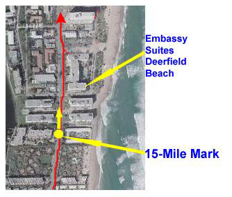
The 15-mile mark was reached at the yellow dot in the picture at the left. When you view the picture I took at the 15-mile mark
here
(we were positioned at the yellow dot looking in the direction of the yellow arrow), you will see the Embassy Suites Deerfield Beach, a building that I have marked on the aerial view for your reference.
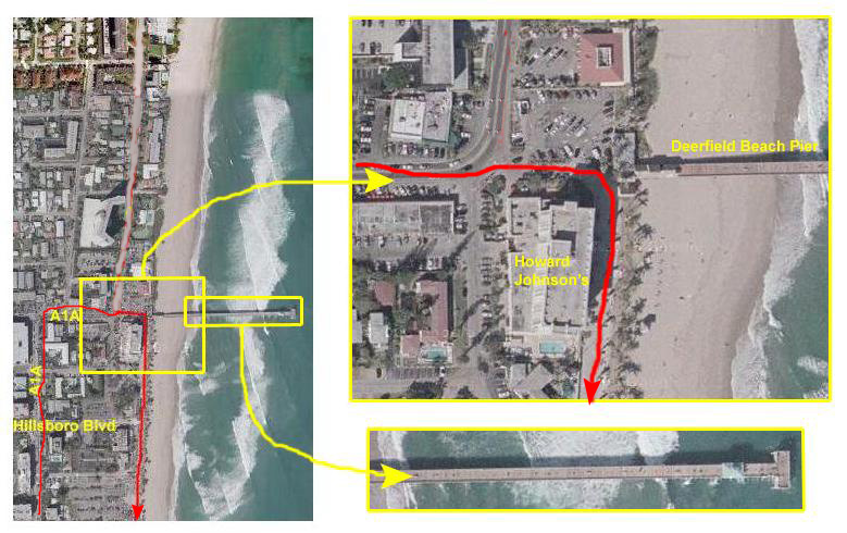
Miles 15-17: South Deerfield Beach to the Deerfield Beach Pier
Hopping back onto our bikes after taking the 15-mile picture, we continued north on A1A for a bit over a mile, which brings us to the curve to the right that is in the middle of Deerfield Beach proper. Just a few blocks ahead of us, the road turns north again to go to Boca Raton, but this is as far as we will be going today.
Another block in front of us is the Deerfield Beach Pier, and so we biked over to the new beachfront renovation and parked our bikes to have a look around. At the corner by the pier, the large building is a Howard Johnson's resort, which includes a restaurant that Fred and I have stopped at a couple of times. It is also fortunate that, right across the street by the entrance building for the pier, there is one of the most welcome cold-water fountains along the entire trip.
When we got our bikes into the bike stand and locked up, we paused to take some pictures. Standing just opposite the Howard Johnson's hotel, here is a picture of
Fred and the Deerfield Beach pier
and, taken from approximately the same location, here is a picture of
me looking south along Deerfield Beach.
While we were relaxing here, I thought I would also take a movie of the immediate area, and you can watch that movie with the player at right.
Today, we decided that we'd do something we haven't done before, and that would be to actually pay our entrance fee and go out on
the Deerfield Beach pier.
Going out there offered some views we hadn't been able to get before, such as this one looking
north along Deerfield Beach.
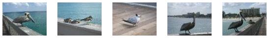
We walked all the way out to
the end of the pier,
just looking down into the ocean, watching the fishermen and observing the pelicans and other birds. In fact, we got quite a few pictures of the birds out here on the pier; some let us get quite close. I have put thumbnails for some of these pictures below, and you can look at the full-size pictures by clicking on the thumbnails:
|
(Click on Thumbnails to View) |
When we left the pier to head home, we took our bikes south along the recently revamped beach road, which is one-way going south. All along the street there are benches, picnic pavilions, water fountains and, of course, the beach. At the southern end of this reconstructed area there is a small boardwalk system that leads over the shore vegetation and
down to the beach.
It is all very nicely done. Here is a last shot of
Fred on the Deerfield Beach boardwalk.
 |
February 28, 2004: Florida Trip Day 8 |
 |
February 25, 2004: Florida Trip Day 5 |
 |
Return to Main Index for Florida Trip Pictures |