|
October 13-19, 2005: A Trip to Florida |
|
September 24, 2005: A Trip to the Arboretum |
|
Return to Index for 2005 |
October 4, 2005
Getting to Green Bay, Wisconsin
 |
 |
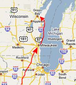
I flew on Midwest Airlines for the first time, getting to Green Bay via a stop in Milwaukee. I didn't leave until late morning, so I didn't get to Green Bay until late in the afternoon. When I arrived, I called Guy but he was busy with a church function and could not get away until dinnertime, so I called the hotel where I was staying and had them send their shuttle for me.
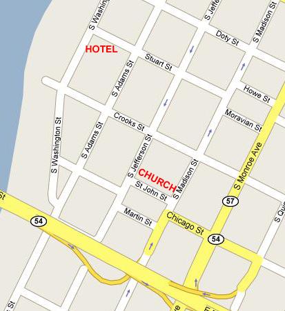
Getting into town was not much of a problem; the route was pretty straightforward. I got to the hotel without a problem, checked in, and then went for a walk. The Quality Inn was on Washington Street, which runs right along the Fox River. It was a pretty nice hotel, and there were two good reasons to pick it. First, it was quite close to Guy's church, so I could walk back and forth, and it had a fitness room with an exercise bike I could use.
I had a bit of time, so I walked a few blocks to a convenience store and stocked up on some sodas to keep in the fridge in my room, and by the time I got back, Guy was calling me on the phone to tell me he was free and on the way over.
Dinner With Guy
Guy arrived pretty shortly, and he was ready for something to eat, so we headed off to dinner. He insisted on treating me for dinner since I'd come all this way to visit, and we drove over towards Lambeau Field (home of the Green Bay Packers). Getting there was pretty easy. We just headed back to the Highway 172 bridge over the Fox River (which we crisscrossed a number of times while I was here), went towards the airport and then took US 41 South just a couple of miles to the Lambeau Field area. (I might mention that I was very familiar with US 41 from my Chicago days. It comes into town from the north as Skokie Boulevard, then turns into Lincoln Boulevard and finally becomes Lake Shore Drive. It goes all the way into Indiana, and I used to follow it to get to I-65 going back and forth to Indianapolis.)
Very much in Green Bay is associated with their football team; it is one of the main businesses in town now. So it was not unusual that Guy picked Brett Favre's Steakhouse near Lambeau Field as a place to try. We both had steaks and salads, and they were OK, I guess, but Guy wasn't impressed- not by the steaks and certainly not by the wine he tried. It was an OK experience, but not a restaurant he would return to, Guy said, particularly for the price.
Guy's Apartment
After dinner, Guy drove us back towards St. John's Church where he is now the priest. Moving here has been an adjustment for Guy. One of the biggest reasons, of course, is that he has lost the close contact with Prudence and Ron. While Prudence and Guy thought of themselves as being very similar, yet very different from the outgoing and boisterous Ron Ruckman, Guy thought the world of both of them and they of him, and when he was in San Antonio, they spent a great deal of time together. He doesn't have that anchor friendship now, and that is difficult for him. The second big reason that Guy really didn't want to move wouldn't really be a factor for another month or so- the weather. Both Guy and I have lived in Chicago, and the winters there are bad enough, but in Green Bay they will be worse. So Guy was already missing the warm climate of San Antonio.
 |
The Church took the library on the third floor and renovated it to become a three-room apartment for Guy. That would probably have been OK, save for the fact that the only bathrooms in the building were the ones used by students- and they were at the other end of the structure. They did have a small bathroom as part of the library area, but to take a shower Guy has to traipse down the empty hallway to the old student bathroom where the Church rigged up a shower for him.
Other than that, the apartment would have been satisfactory as a temporary solution, but that made it a hassle. (I might note that about nine months later, Guy was able to get the Church to spring for an actual apartment for him nearby, and he is now much more comfortable. He should be moving into the rectory shortly.)
I'll try to describe the apartment with some pictures so you'll get an idea of what it was like. First, of course, you have to climb some stairs to get to the second floor, and then walk down the hallway to the end of the building and up a couple of steps to the hallway leading to Guy's apartment. Just before you come through the door into the apartment, there is a small bathroom with a sink and commode right in front of you. When you enter the apartment, you are actually in one end of the kitchen where guy has put his dining room table. At the other end of the room is the kitchen itself, and the kitchen area is quite adequate for the use Guy makes of it.
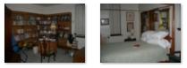
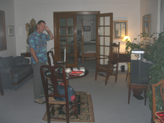
As you are facing the kitchen area, there is a door to your left that leads into the living room; this picture is a view from the living room into the kitchen/entry. The living room is pretty good sized, and there seems to be room for all of Guy's antique furniture that was moved up here from San Antonio. I took two pictures in the living room to show you both sides of it (there is a circular table in the middle) and you can view those pictures here and here. Guy has arranged things very nicely, and there are plenty of plants around.
The last room of the apartment is a combination bedroom and study, and it is reached through the French doors that you just saw here. It is a very large room, and Guy has been able to get not only his poster bed but also his large bookcases and desk into it. If you stand in the doorway and look into the room, the study is on the left and the bed on the right, exactly as shown in the two pictures below (click on the thumbnails to view the full-sized images):
|
After showing me around his apartment, we made plans to meet about noon the next day. Guy had a church function he had to do in the morning, and meeting at noon would give me a chance to work out in the morning, so that was fine. Guy dropped me off at the hotel.
October 5, 2005
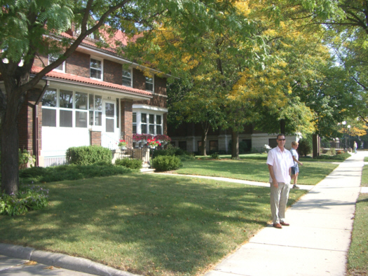
St. John's Church
 |
|
|
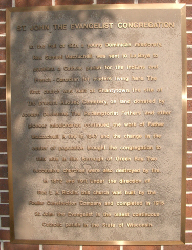 |
In the Fall of 1831 a young Dominican missionary, Rev. Samuel Mazzuchelli, was sent to La Baye to establish a Catholic parish for the Indians and French-Canadian fur traders living here. The first church was built at Shantytown, the site of the present Allouez Cemetery, on land donated by Joseph Ducharme. The Redemptorist Fathers and other pioneer missionaries continued the work of Father Mazzuchelli. A fire in 1847 and the change in the center of population brought the congregation to this site in the Borough of Green Bay. Two successive churches were also destroyed by fire in 1872 and 1911. Under the direction of Rev. L. A. Ricklin, this church was built by the Foeller Construction Company and completed in 1915. St. John the Evangelist is the oldest continuous Catholic parish in the State of Wisconsin.
|
|
We have come out into the church at the front of the nave, and walking across the front of the sanctuary you can see the baptistry and, on the far side, statuary and the hymnal board. There are doors on both sides leading back behind the baptistry.
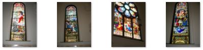
One of the really beautiful things about this chapel, which I don't recall seeing in San Antonio, was the beautiful stained glass, described by Guy in the movie that I made. You can watch it with the player below:
|
|
|
If you look very closely at the last window, and look just to the right of the saint's knees, you will see a small representation of the Statue of Liberty. Guy tells me that this is the only known stained-glass window in a church in the United States that has a Statue of Liberty in its design. I'm not about to contradict him!
We walked all the way through the chapel to the front of the church, and then descended the steps in the entry hall to go out the front doors and back to the rectory. There Guy showed me around the building, including his office. Then we headed off to get some lunch and see what Green Bay is really famous for.
Lambeau Field
Guy had an errand to run out by Lambeau Field anyway, so we left the church and drove back towards the airport and then retraced our drive yesterday. As we were crossing the bridge over the Fox River, I was able to look back and catch a glimpse of downtown Green Bay and St. John's Church- it is the red brick spire nearest to us. We crossed the river and then headed south. We were going right by Lambeau Field so we stopped to see what it was like. You could get inside where the shops and stuff were, but you couldn't get to a place where you could see the field without taking a tour. So we just walked around a bit and then headed further west to get some lunch and so Guy could stop at Barnes and Noble bookstore.
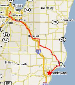
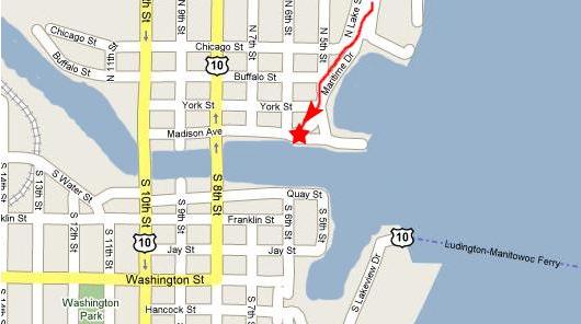
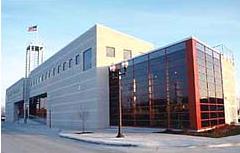
Manitowoc, Wisconsin: The Maritime Museum
 |
 |
We headed off down I-43 towards Manitowoc, but got off the expressway a bit early to see some of the fall color. So we came into town from the north, along the lakeshore.
 |
|
|
Most of these models look as if they would have taken an incredible amount of time to put together. I wondered where the museum got them all. Of course, right at the entrance to the galleries there was a model of the USS Cobia, the submarine that is moored right outside. The Cobia is the centerpiece of the museum, and probably its main attraction. Our admission to the museum included a tour of the Cobia.
But before we went outside to tour the Cobia, we spent more than an hour wandering around the museum looking at the various exhibits. We were only able to skim the surface of what is here, but I think we did right well. I've culled out some of the many pictures I took of the various exhibits and models for you to look at. To see the full-sized images, just click on the thumbnails below:
|
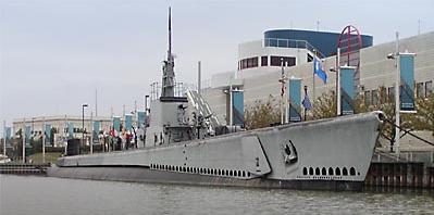
Manitowoc, Wisconsin: The USS Cobia
 |
I took two movies of his explanations before we went below, and you can watch those movies using the movie players below:
|
|
COBIA was launched in November 1943. In June 1944, it began the first of six war patrols in which it sank thirteen Japanese vessels for a total of 20,000 tons of enemy shipping. By July 1944, COBIA had established itself in the annals of World War II sub history by attacking an enemy convoy bound for Japanese-held Iwo Jima. COBIA sank two vessels, including a troop transport carrying a Japanese tank battalion of twenty-eight tanks. U.S. Marines considered this sinking critical to their success in capturing Iwo six months later. COBIA's most colorful battle took place in February 1945, when it engaged two armed Japanese sea trucks in a running gun duel. COBIA sank both of them, but not without the loss of Ralph Clark Houston, a 20 mm gun loader and COBIA's only casualty of the war.
Ever since World War II, COBIA's role has changed to keep pace with its various missions. By 1959, the U. S. Navy considered COBIA obsolete as a deployable warship and transferred it to the Milwaukee Naval Reserve Center. There it served as a training platform for the next eleven years. In 1970, the Navy decommissioned COBIA and it was towed to Manitowoc to serve as an international memorial to submariners. In 1986, COBIA was incorporated as a part of the Manitowoc Maritime Museum, declared a National Historic Landmark, and placed on the National Register of Historic Places.
|
|
The next major stop on the tour was just about midway down the boat passageway- the operations center. From here, the captain controlled the boat. Today's large submarines seem to have, if movies can be believed, commodious operations centers, but on a boat this size the operations area seemed quite small. While we were here, our guide explained and demonstrated the diving procedure to us. You can watch his demonstration using the movie player at left.
 |
|
|
In the movie, you heard the guide explaining about how much food was brought aboard and what the meal service was like. He also made the point that if seas were rough, it was sometimes tough even for seasoned sailors to keep food down. But even on good days, one couldn't help but wonder about the "facilities" on board (kind of like wondering how the astronauts take care of the same functions). I thought it would be a good idea to go back forward and show you what the facilities were like.
In the stern were first the engine room, with all the controls and the machinery for the boat's diesel engines and, behind that, the aft torpedo room and tubes. In both of these areas there were nooks and crannies where fold-down bunks afforded a space where sailors not on duty could sleep. (Although I'd imagine the engine room wouldn't be the quietest place to sleep, I guess sailors got used to it out of necessity.)
The tour was very interesting and lasted over an hour. Although some of the people in our tour group were older, I doubt that any of them were veterans. World War II is so far in the past, now, that even the youngest veterans of even the last year of the war must be over eighty years old by now, and I doubt that many of them would be traveling extensively or climbing up and down narrow gangway stairs as we had to do. But when the tour was over, we listened as some final questions were dealt with and then crossed the boarding ramp back to the museum.
Manitowoc, Wisconsin: The Town and Shoreline
After leaving the Cobia and the Maritime Museum, we were going to head back to Green Bay, but first, since we were here, we thought we would take a quick tour of downtown Manitowoc just to see what it looked like. As you can see, it was a pretty normal Great Lakes town- everything built a lot more solidly-built than down in Dallas. We circled through town to head back by the museum to the lake shore, and on the way passed what we presume was the courthouse in Manitowoc; we weren't sure about the reason for the outside stairs.
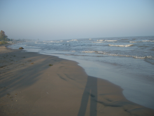 |
It was cold walking around, but I also wanted to take a couple of movies so you could get a better idea of what the shoreline was like, and you can watch those movies using the two players below:
|
|
|
When we got cold enough, we piled back into Guy's car and headed back to Green Bay. It was about an hour's drive back and when we returned we found a local diner where we had dinner. It had a little buffet that was actually quite good. Then it was back to the hotel and Guy's apartment. We made plans to set out early the next day for our tour of Door County.
October 6, 2005
Door County: Fish Creek
 |
 |
We met in the morning about nine o'clock, and we headed off for a day in Door County. Guy had been to Door County quite a few times, both on business for his Church and for his own pleasure. It is just the kind of place where he and Ron and Prudence would have taken their day trips in Texas- scenery, antiques, B&Bs and so on. So Guy was the guide and he knew where he was going.
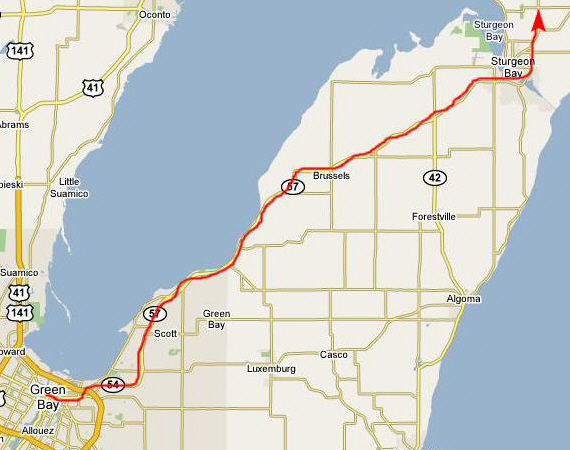
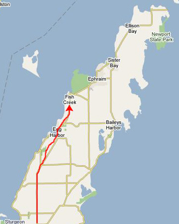
We left the city of Green Bay and headed northeast into Door County, which is basically a peninsula that sticks northeast up into Lake Michigan. We drove for about an hour to Sturgeon Bay, a picturesque town on a smaller bay off Green Bay. Next, we drove northeast along the east side of Green Bay and through the small town of Egg Harbor. Finally, we continued another half hour or so to the town of Fish Creek.
|
|
Next, we continued northeast out of Fish Creek towards Peninsula State Park. Between the two it is marshland, again much like some of the areas near Muskegon. We found a turnoff just before the State Park where we could see the marshland and Fish Creek.
Door County: Peninsula State Park
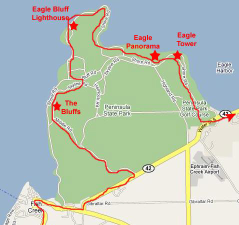 |
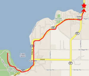
On the map at right, you can see our route from Fish Creek through the park and then back on the road towards Ephraim and Sister Bay.
The Bluffs
As I looked up and down the line of bluffs, I thought them to be very unusual, nestled as they are in the forest. It looked as if there would be many easy routes up and down them, but I could also see that some places would be dangerous to climb. I really wanted to get a picture of myself on the cliff face, but the only way to do it was to climb back down, give my camera to Guy, and then climb back up to a different spot so that Guy could take the picture.
Eagle Bluff Lighthouse
 |
It wasn't until the completion of the Erie Canal that the Great Lakes began to grow into a vital transportation network for products and people. As lake shipping increased, so did the numbers of shipwrecks- caused by unmarked shipping lanes encountering submerged shoals and reefs, dangerous straits and narrow entrances to harbors and rivers. This prompted the government to establish aids to navigation throughout the Great Lakes.
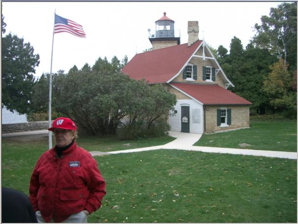
The first lighthouses of the Great Lakes were built in the 1820's, and Door County, with its nearly 250 miles of rugged shoreline, boasted 13 of them. Eagle Bluff Lighthouse was built in 1868 to guide ships through the east channel down to Sturgeon Bay and Green Bay, away from the park bluffs on one side and the large, flat shoals of the Strawberry Islands on the other. It was constructed at a cost of $12,000; the materials were brought in by boat from Detroit, Michigan and Milwaukee. The light tower is 43 feet tall, so the light shines 76 feet above the bay.
The tower was equipped with a mid-sized Fresnel Lens, which gathered the light from a lamp and via refraction, projected a narrow bright beam visible for 16 miles across the water. The source of the light was a wicked oil lamp, later fueled by kerosene. Here at Eagle Bluff, there still is no electricity. The beam that shines across the bay each night is powered by energy created from a small solar panel at the top of the tower.
For 58 years, from 1868-1926, keepers and their families lived at Eagle Bluff and tended the light. The light was automated in 1926, and the next 34 years saw the automated light shining over the bay, but the keeper's house was dark, mostly empty, and gradually it deteriorated from lack of use and interest. In 1960 the Door County Historical Society selected Eagle Bluff Lighthouse to research, restore, completely furnish and open as a museum. The restoration took 4 years and an immense amount of work. After repairing, removing paint, varnishing, wallpapering, and cleaning, the house was then furnished with choice examples of furniture and artifacts of the period. Members of the last keeper's family participated in the restoration, contributing photos, documents, artifacts, and information on how the house was furnished and arranged.
The furnishings in the house were not the original items. Instead, the restoration team relied on the memories of Walter Duclon, the youngest of the last keeper's children, to find and restore items as close to those as described as possible. Walter was actually able to help recover some of the original artifacts. In 1970, Eagle Bluff Lighthouse was listed in the National Register of Historic Places.
|
|
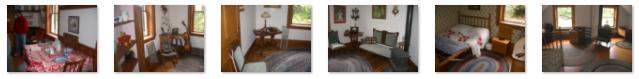
While on the tour, I took a number of pictures of the individual, restored rooms in the Eagle Bluff Lighthouse. If you'd like to see them, just click on their thumbnails below:
|
Eagle Panorama
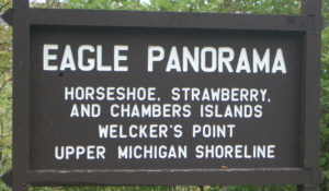 |
This is a good place to point out one of the biggest differences between living up north as opposed to living in Dallas. Up here, you have the opportunity to be enchanted with Fall color because of all the hardwood trees and the cold nights in September and October. Down home we don't have the hardwoods (live oak is most common) nor do we have cold nights until well into November or December. So it was a pleasure to be able to be amazed at all the color I saw, with this being an excellent example.
Eagle Tower
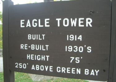 |
It's not a long way up, but the view from the top belies the short climb. I couldn't help but think, looking out on the flat islands and water that this entire area could be just as lonely and forbidding as any in the desert West or southeastern pine barrens, but the chill in the air and the overcast sky lent an eerie quality to everything.
Guy and I took turns taking pictures of each other here at the top of Eagle Tower, and you can see those pictures here and here.
|
|
Door County: Sister Bay
 |
What made this restaurant so unusual was that it had grass growing on the roof, as you can see in this picture of the building looking from the parking area beside it.
But the restaurant turned out to be very good, with lots of Swedish and German food. It was relaxing to just sit down for a while, but after lunch, we got back in Guy's SUV and continued north along Green Bay.
Door County: Northport
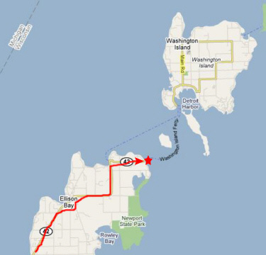 |
Then it was on through Ellison Bay to the end of the Door County peninsula at Northport. Northport is not actually a town, but rather the boarding ramp for the Washington Island Ferry. We found that the Ferry leaves here for Washington Island on a varying schedule throughout the day and from day to day. It actually made me wonder if, during the winter, there is too much ice for the ferry to operate, and how long the residents of Washington Island might be isolated.
|
|
Well, this was as far north as we could get, so we had to turn around and retrace our route until we could find a route across the peninsula to Bailey's Harbor.
Door County: Bailey's Harbor
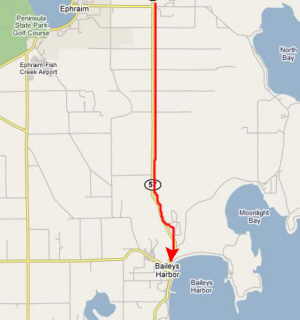 |
We retraced our route back to Ellison Bay, but then took Route 57 south and across the peninsula to the town of Bailey's Harbor. Just before entering town, we stopped at an antique shop that Guy knew about to look around and see what we could see. The antique shop was actually comprised of two or three buildings with a yard full of knicknacks. Guy told me that one building had most of the furniture items and the other was mainly small stuff and crafts, and we spent most of our time looking at the furniture. Just outside that building was a colorful arrangement of flowers and garden items and I thought it well worth a picture.
Just adjacent to the antique shop was a little driveway, and alongside that was an excellent example of some of the early fall color here on the peninsula.
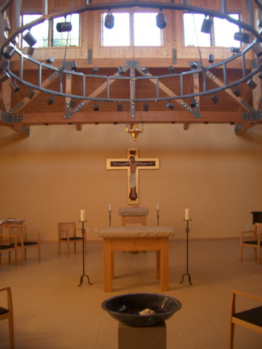
Door County: St. Joseph Retreat Center
 |
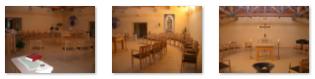
When you turn into the grounds of the retreat, there are first some buildings housing some historical information and crafts, and then the entry drive brings you to the St. Joseph Retreat Center main entry.
St. Joseph Retreat Center is a ministry of the Priests of the Sacred Heart and is situated on more than 400 acres of farm and woodland. It is an ideal setting for rest and renewal and can be used by groups or individuals of any denomination or faith. From the entry, there is a main entrance into the administration building where the clergy who work here permanently or frequently have their offices. The buildings are very nice, done in a rustic, yet modern motif. One of the most pleasant rooms was the solarium, which was at the back of the administration building bordering on the forest and the lake. It was a beautiful room, and it made me wish I had one just like it- with the forest and lake outside, naturally.
Just next to the offices there was a very handsome staircase to the second floor, where the buildings connected to the dormitory wing of the complex. Here is another view of the stairway showing Guy on the stairway landing. At the top of the staircase were some audio-visual rooms, meeting and conference rooms, and more offices, plus the hallway to the dormitory wing. There are over 25 private rooms in the buildings, plus dining halls and kitchens.
 |
|
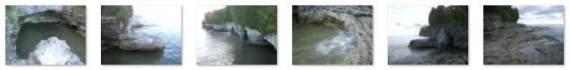
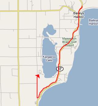
Door County: Whitefish Dunes State Park and Cave Point
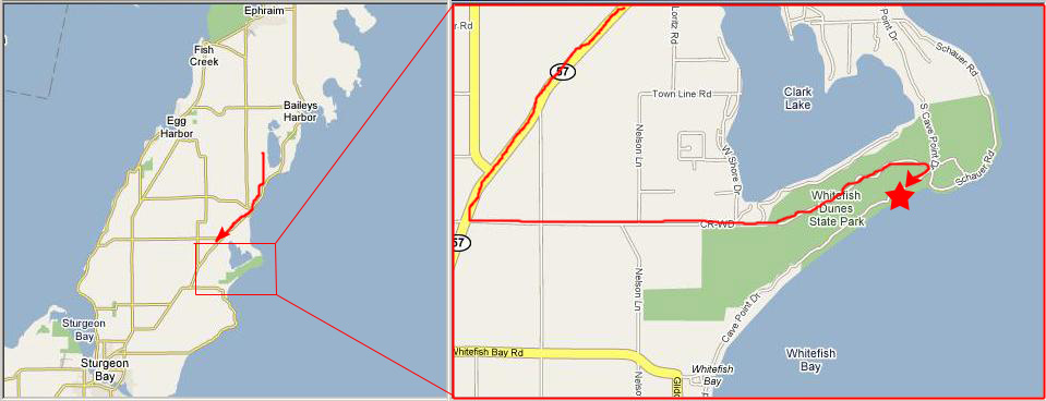 |
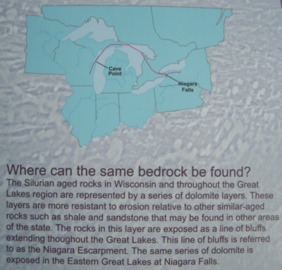 |
It was extremely interesting to learn that the cliffs and bedrock that are found here, in Door County, are part of the same huge rock formation that was laid down, all at the same time, and which covered a huge arc from Wisconsin, across the top of Michigan, through southern Ontario and all the way to Buffalo, New York and Niagara Falls. From the map, it almost seems as if Lakes Michigan and Huron are "following" that arc, and perhaps they are, responding to the geology far below the surface of the land we see today. I've done some additional investigation of this on the Internet, and I've learned that geologists have compared rock taken from the base of Niagara Falls with rock taken from Cave Point, and found their composition to be identical, whereas rocks taken from the west side of Green Bay (just a few miles from here) and rocks taken from just ten miles south of Buffalo show marked differences- the strata are that well-defined.
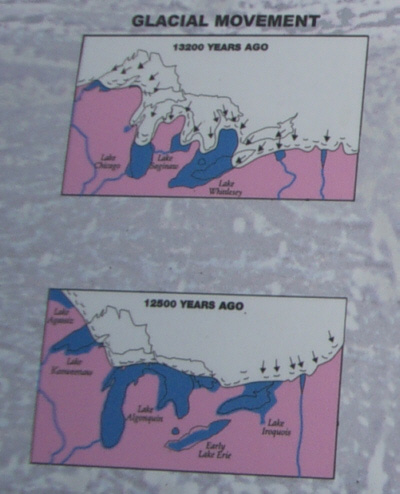 |
Approximately 410 million years after the Silurian Period, the most recent glaciation of the northern hemisphere took place as massive lobes of continental ice sheets advanced and retreated several times over the Upper Midwest. As the ice covered and uncovered the area, a series of ancient lakes came and went. As a result of scouring by these ice lobes and the drainage system they created, the modern Great Lakes were formed. This glaciation was responsible for much of the erosion that accentuated areas such as Door County and many of the prominent rock outcroppings in the Midwest.
As the scouring action of the ice lobes removed the softer rocks and sediments, the more resistant dolomite remained to be attacked by thousands of years of erosion through wave activity. The jagged cliffs and sea caves that we could see here are examples of those wave-cut features.
|
|
The continuous act of erosion is slowly removing the bedrock where water and land meet. As water enters crevices and other openings in the rocks it collects and freezes in the winter. As the water freezes it expands and enlarges the openings until gravity does its part to remove the large sections. Water also erodes in a less visible but possibly more significant way termed dissolution, the chemical breakdown of the bedrock as a result of it's reaction with water. Erosional processes have been changing the way Cave Point looks for millions of years, and will continue to do so in the future.
|
|
|
|
This was a really intriguing place and we were here until we started to lose our light. While here, I took a number of other pictures, and you can look at them by clicking on their thumbnails below:
|

Then, it was back to Green Bay and dinner at a restaurant in town.
Guy came by for me the next morning, and took me out to the airport for my flight home. It was a good visit, and now I can visualize things when Guy writes or talks about what he is doing. I know he'd prefer not to be in Green Bay, so far from his family and his friends here in Texas, but he must do what is needed and where it is needed and, for now, that means Green Bay. I know that Prudence and Ron will eventually get up here to visit, and I am sure they will like Door County as much as I did and Guy does.
You can use the links below to continue to another photo album page.
|
October 13-19, 2005: A Trip to Florida |
|
September 24, 2005: A Trip to the Arboretum |
|
Return to Index for 2005 |