


|
July 1-10, 2006: Our Summer Trip to Glacier National Park |
|
May 29-31, 2006: A Visit With Ron and Prudence |
|
Return to Index for 2006 |
In June, I took one of my monthly trips down to Fort Lauderdale. What with all the hassle and expense I'd put into the condo, it seems a shame not to use it as often as I can. So my habit recently has been to be in Florida over one of the weekends that Fred is at his mother's house in DeLeon, weekends that I wouldn't see him much anyway.
I really don't do much except bum around the condo or with Ron Drew or Ty and Scott. It is just a time for me to relax and not do much of anything. However, on my last trip here I bought a new bicycle to replace the old one I'd gotten at Target years ago. The new one, a Trek, is a lot easier to ride, much more comfortable, and technologically far superior- even though it isn't a thousand-dollar bike or anything like that.
I have ridden it on some short rides the last time I was here, but this time I thought I might really put it to the test.
A Century Bike Ride
Introduction
What I thought was that I would ride further and longer than I've ever done. The longest ride up to now was about 25 miles up to the north of Boca Raton. Actually, Fred has ridden up there with me on at least one occasion. The scenery is so nice that I thought I would go much further. The problem would be that to go much further it would be exhausting to try to go up and back in a single day, so my plan was to take a few things with me in a backpack and stay overnight somewhere north of Palm Beach. Fred and I have done 50 miles in one day, and I thought that I should be able to set a goal of 75+ miles in a single day, doing the return trip the next day.
I planned the trip to be Wednesday, June 7 and Thursday, June 8. I knew I'd be returning to Dallas on the 9th, so these two days fit well into the schedule. I also knew I'd want to get an early start so that I could cover as much ground as possible. I made sure to charge up my camera batteries because I expected to take quite a few pictures. To record the trip, I would also stop every five miles (the new bike has an odometer) to record exactly where I was in a still shot and a short movie.
Now that I am putting the resulting pictures and movies into my album, it occurs to me that, looking at the pictures themselves, you don't get a very good impression as to where I was when each was taken, except that I simply name the location. Many of you aren't familiar with the geography of the Florida East Coast, so you wouldn't know where these places were. So what I thought I would do would be supplement the pictures with a set of maps taken from Mapquest or Google Maps. That way, you could not only see where each picture was taken, but I could also trace the actual route on the maps. Once I started copying maps from the Internet, though, I realized that, instead of maps, I should use actual aerial views; these would be much more illustrative- not to mention much more attractive. Google Maps has excellent aerial views, and I have chosen to use views from that site.
What I will do in the narrative that follows is use aerial views to show you the route I took. I have clipped aerial views that cover the entire route- except for some stretches that simply follow the same street or highway for a number of miles, with no turns or even points of much interest. Sometimes I will zoom in to show a point of interest (like where I stopped for lunch or to take one of the pictures; sometimes I will zoom out when the route is simply straight and long. I'll try to cover most of it with the aerial views. I suppose it might get a bit monotonous for you, but, for me, it will record the longest single-day bike ride that I've ever taken (or as you will see later, am ever likely to take). I hope you enjoy the chronicle.
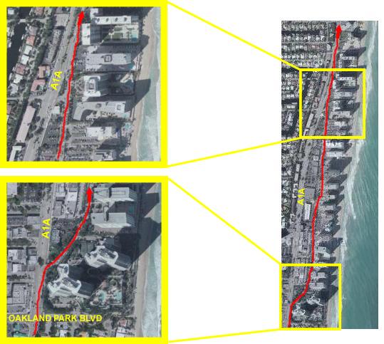
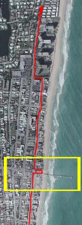
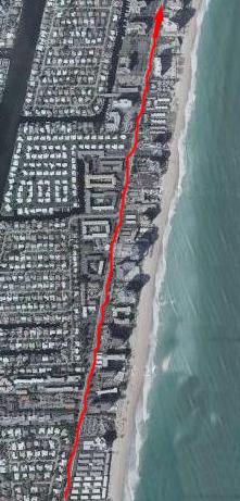
Start to Mile 5: My Condo to Oakland Park Blvd.
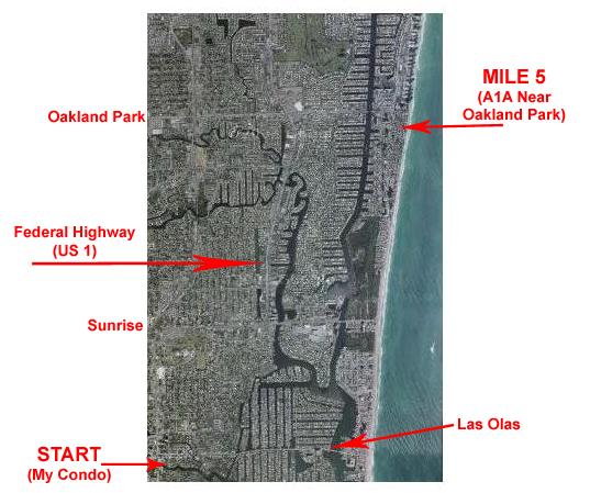 |
When we do go for a bike ride, we usually go all the way up the beach until A1A moves inland a block or so (to allow the construction of buildings right on the beach). We continue to stick as close to the beach as we can.
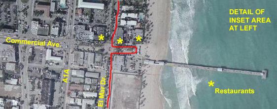
Just a bit south of the next major east-west street above Oakland Park, Commercial Avenue, we can get right back to the beach again, and we usually end the ride at an area called Lauderdale-by-the-Sea. It is located where Commercial Avenue ends right at the beach, and there are restaurants right on the beach where you can have breakfast or lunch. It makes a pleasant, but not strenuous, ride.
You may already have seen pictures taken there earlier in this album, and you'll see the route to get there in more detail shortly.
But first, the ride begins by getting from the condo to Las Olas Boulevard and then heading east:
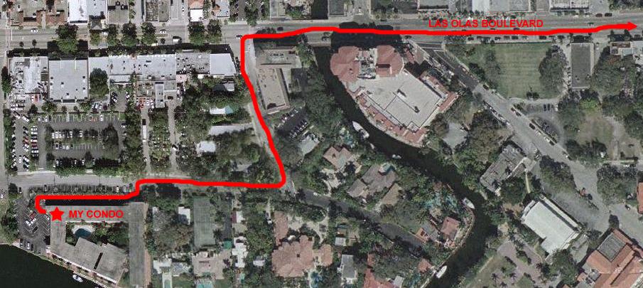
My unit is on the second floor in the building marked, in the position where the star is. So I just carry the bike down one flight of outside stairs and I am ready to go. I go through the parking lot and then onto SE 4th Street heading east, turn on to SE 11th Avenue heading north, and then out onto Las Olas Boulevard going east. On the SE corner of Las Olas and SE 11th Ave is a branch of the Northern Trust Bank from Chicago. I worked with many folks at that bank when I was at Continental Bank many years ago, and also worked with them when they were a customer of Cullinane Corporation. And just across the Himmarshee Canal from the bank is a new commercial/residential building that has just been completed (at least in the last year) and that gives me an idea of how old this aerial view is.
From this point, it is a straight shot along Las Olas to the beach. I've zoomed out a bit to show more of the route in the picture below. Once out on Las Olas, it is a block or two before I pass in front of the Floridian Restaurant (on the corner of the block in the lower left of this picture). This is a favorite place to eat; it has lots of local "color," has an extensive menu, and is open 24 hours. I'll often get a bite to eat if I've taken a late flight down. Another block east and on the north side of the street is the Fort Lauderdale Hospital, one of the first in the city, which is now a "boutique" hospital catering to people in the immediate area. Then it's across one of the many canals in Fort Lauderdale and I am into the Las Olas Isles area.
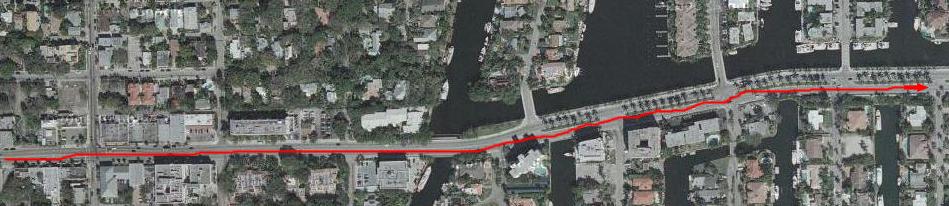
These islands are artificial, of course, and were built to take maximum advantage of the sheltered Intracoastal Waterway (which is still some distance east). The "fingers" on the north side of Las Olas are connected to the causeway by short bridges; the ones on the south are connected to the causeway directly. Each island is just a single street, with million-dollar homes lining the street on either side. On the northern islands, there are also a good many small apartment complexes; these look like very small motels, usually with just five or ten units. But, over the years, most of these are disappearing, replaced with larger homes.
Lining the canals on both sides, behind the homes, and around any water edge, are boat docks. Being the "Boating Capital of the World," Fort Lauderdale has more private boats than anywhere else, and they all have to be kept someplace. There are not nearly enough marinas for them, so every available foot of every single canalside is given over to docks. For the most part, the boats parked in the slips belong to the homeowners, but there is usually a good deal of additional space that landowners can rent out. Ty and Scott once lived on a boat they kept docked on one of the islands you see here. Rents for dock space range from $300/month for a small boat to more than $1000/month for a 50-footer kept in a desirable spot. There are canals and waterways all over Fort Lauderdale, and they are filled with boats. The larger boats must be kept in spaces that have unrestricted access to the Intracoastal ("no fixed bridges" is the term that is used in advertisements to denote these kinds of spaces). All of the spaces you see here are "no fixed bridges."
In the picture below (where I have zoomed out yet again), I've shown the route across the causeway. As you can see, there are many of these artificial islands, some north-south and some east-west, most of the connected to each other and/or Las Olas Boulevard. But alongside all of them, in every available space, are boats, boats and more boats. And this doesn't even count all the marinas spread over the area (where the REALLY big boats are docked)!
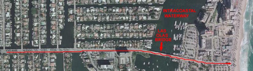
Technically, the entire beach area is an island, but it is a barrier island. There are bridges to it every so often north and south, and then inlets that cut through it once in a while. One of these inlets is south of us- Port Everglades and the Everglades Inlet. This is where the cruise ships go in and out and this particular inlet is large and deep. The next inlet north is at Hillsboro, and we will get there shortly. So to get to the beach, we must cross over the Las Olas Bridge, which is a drawbridge- like all the ones along the Intracoastal Waterway. Down the east side of the bridge we are at the beach. The last major street you cross before you run out of land is A1A/South. (A1A splits a ways north of here into southbound and northbound one-way streets, and they come back together south of here at Bahia Mar marina. Let's take a closer look at this area:
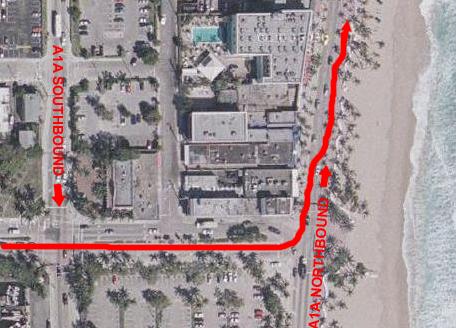 |
Incidentally, you many wonder why the street is called "A1A." The name is very old, and dates from at least the late 1950s. US 1 has been the main highway north and south along the east coast since the 1940s. Before expressways, it wound all the way from Bangor, ME to Key West. In the countryside, it was a 2- or 4-lane highway. Where it went through or close to populated areas (which was often) it was a major city street. It must have been quite an adventure to follow it, particularly through cities where signs would have to direct you through all the twists and turns. I've driven on most of the highway, and it is about as built-up as a highway can get. That's why, when the Interstate Highway System was begun, one of the first highways built was Interstate 95, which essentially paralleled US 1- again, all the way from Maine to Miami. (Interstate 95 actually ends in Miami and turns back into US 1 for the trip to Key West.)
Anyway, people were so used to following US 1, that an alternate designation for Interstate 95 came into common use- "Highway US 1A." Not too many people use that term now, though, since interstate highways are so common (and most of the folks who needed that designation are no longer driving). People who took Interstate 95 could get to Miami relatively quickly. People who took US 1 could do the same, but there would be two differences. On the good side, there would be many services (restaurants, gas stations, hotels and stores) along the way. On the bad side, there would be oodles of stoplights, and so the speed limit would be much less most of the way. But no matter which highway was taken, the bad thing was that the traveler would miss almost ALL the spectacular scenery along the South Carolina/Georgia/Florida coastline.
People had been moving close to the beach for years, and it was pretty much all built up by mid-century (although the population of cities like Fort Lauderdale and Palm Beach was nothing like it is today). But there was a "Beach Road" that was, for the most part, a two-lane road. In some areas, the road simply went along the shore through the dunes, but in the areas first populated, there would be homes on the west side of the road or, in some places, on the beach side as well. This road crossed all the picturesque inlets, passed by the marinas and in general was a pleasure to drive (albeit not the fastest way to get where you were going). But it WAS the scenic route, and it WAS an alternate route north and south. Since Alternate US 1 (A1) was taken, this highway was dubbed Alternate US 1 Alternate or, quite quickly, A1A.
If you ever have the chance, start in Savannah, Georgia on US 1 and follow that south through Jacksonville, Florida to pick up A1A through St. Augustine. Follow A1A all the way to Miami where it ends and merges back into US 1 and continues to Key West. The drive will take you three days, but it will be well worth it.
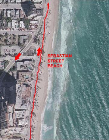 |
Sebastian Street Beach is notable in that it is the unofficial gathering spot for gay and lesbian beachgoers. It is just understood that if one gay person tells another that he is going to the beach, that's where he or she can be found. Oftentimes, there is some watchable scenery here, but today, all you can see are the lifeguard stations and maybe a few umbrellas. We will continue north along the beach in the A1A bike lane.
 |
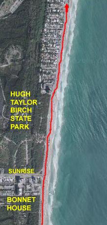 |
It can fairly be said that neither Bonnet House nor the Hugh Taylor Birch State Park would exist today were it not for The World's Columbian Exposition, held in Chicago in 1893. One of the visitors to the Exposition, was Hugh Taylor Birch, a prominent Chicago attorney. One of the most popular exhibits was one detailing the new development getting underway in South Florida. It impressed Mr. Birch so much that he left his home in search of peace and tranquility in the south Florida wilderness. It was at this time that Henry Flagler's East Coast Railway was opening the sunshine state to tourism. In 1893, the railroad stopped in Titusville, Florida. To travel beyond this point, Mr. Birch reportedly set sail in a boat loaned to him by Henry Flagler.
Fate took another hand in events when Mr. Birch was blown ashore to safety in Lake Mabel (Port Everglades today) during an unseasonable Atlantic storm. He found himself near Fort Lauderdale, built in 1838 during the Seminole Indian conflict by Major William Lauderdale. Although the area was populated sparsely, he believed Fort Lauderdale was where "God meant him to be" and was where he would stay. He purchased over three miles of oceanfront property along Fort Lauderdale's beach for less than one dollar per acre. Henceforth, he spent the winters on his beachfront land where he could absorb the seascapes, enjoy a daily swim in the ocean and grow fruits and other plants.
Throughout his life, Hugh Taylor Birch had a love of the out-of-doors and the solitude found therein. During his lifetime, Hugh Taylor Birch donated over 1,760 acres of land to various organizations and persons in order to preserve the wilderness he had always cherished, including the expanse now known as Hugh Taylor Birch State Park.
But what was the connection to Bonnet House? Mr. Birch's daughter, Helen Birch was a musician, composer and poet who had been culturally nurtured in Chicago society and in travels abroad with her mother. In 1917, Helen married Frederic Clay Bartlett. He had been born in Chicago to wealthy family and, after an excellent education, left Chicago at age 18 to study art in Europe in 1893. By 1915, he had become both an accomplished artist and an enthusiastic collector of art and Old World treasures discovered on his travels. His work as a commissioned artist opened vast horizons and opportunities, one of which was an introduction to Helen Birch one summer in Chicago.
Her marriage to Mr. Bartlett at age thirty-seven was the impetus for the gift of a "house lot" from her father's oceanfront land. When Frederic Bartlett asked his father-in-law how large the "house lot" was, Mr. Birch replied, "Oh, as far as you can swing a cat!" Seven hundred feet along the ocean, stretching inland to the Intracoastal Waterway (Upper New River at the time), the lot encompassed thirty-five acres of land upon which Bonnet House would evolve.
From 1920 to 1925, the Birch-Bartlett family enjoyed their winters at Bonnet House until, sadly, Helen died of cancer in that year. Despite the tragedy of Helen's death, which drastically altered the lives of Mr. Birch and Mr. Bartlett, the two men remained close friends throughout their lives.
Evelyn Fortune was born in Indianapolis, Indiana in 1887, also to a wealthy family. She gained an appreciation for nature during her youth, and pursued interests in needlework, cooking, sewing and flower arranging. She married Eli Lilly of the pharmaceutical family. Following her divorce from Mr. Lilly, Evelyn and her daughter began to spend their summers in Beverly Farms, Massachusetts, where she became acquainted with the Bartlett family. After the death of Mr. Bartlett's second wife, Helen Birch, the friendship of Frederic and Evelyn grew to a love and then, marriage in 1931.
The marriage of Frederic and Helen Birch Bartlett began a family history in which art and philanthropy merged brilliantly. Their life of collecting art is epitomized in the world renowned collection of Post-Impressionist paintings given to The Art Institute of Chicago as a memorial to Helen Birch Bartlett. Twenty-four paintings by master artists such as Van Gogh, Picasso, Matisse, Seurat, Gauguin and others have been in the forefront of modern art collections in America. ("Sunday Afternoon on the Island of La Grande Jatte" by Georges Seurat. This painting was purchased by Frederic and Helen Bartlett in the early 1920s and given to The Art Institute of Chicago where it hangs today.)
Evelyn Fortune Bartlett had a refined sensitivity to the Birch-Bartlett family in the loss of their beloved Helen. Her friendship with them grew to a love and respect that was mutually shared. The genteel demeanor of Frederic Bartlett disarmed the shyness that Evelyn had experienced in her life. Their marriage brought forth a combined creativity which evoked a lifestyle of spirited fun.
From 1931 to 1941, Mr. Birch spent his winters at Bonnet House with the new Mr. and Mrs. Bartlett until, at age 93, he built his own beachfront residence north of Bonnet House in the "Oaks", known today as Birch State Park and Recreation Area. As owner of the land, he deeded the park to the state of Florida and granted an easement to the local government to construct Sunrise Boulevard. Mr. Birch died in 1943, and the traditions he had initiated were carried on by Frederic and Evelyn Bartlett. For more than six decades, the family's yearly schedule has included the moves from Whitehall, their northern residence in Beverly, Massachusetts, and Bonnet House, their winter retreat. Frederic died in 1953.
One cannot help but be in awe of the overwhelming gesture of philanthropy made by Evelyn Fortune Bartlett. Her determination to preserve the estate she believed should remain unchanged resulted in her deeding of the property to the Florida Trust for Historic Preservation in 1983. Members of the Smithsonian Institution and the National and Florida Trusts for Historic Preservation have been instrumental in protecting this site which is listed on the National Register of historic Places. Mrs. Bartlett died in 1997.
All this was going through my thoughts as I cycled north along the beach, past these two open spaces and pieces of history.
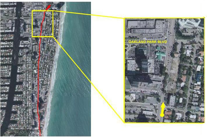 |
I continued biking north along A1A, eventually moving a bit away from the beach. Just a short way before reaching the next major street, Oakland Park Blvd., I reached the 5-mile point in the bike ride.
|
|
Then I continued north, crossing Oakland Park Blvd.
Miles 5-10: Oakland Park Blvd. to Pompano Beach
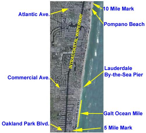 |
From the area just south of Oakland Park Blvd., this five-mile section covers a ride along the condominiums on the Galt Ocean Mile, a short stretch along A1A, and then a jog back to the beach for the ride up to Lauderdale By-the-Sea.
From there, we continue north, back to A1A again, and then a long stretch up to Pompano Beach. Another jog over to the beach and we head north once more, with the segment ending just north of Atlantic Blvd.
Let's take a look at the ride in more detail.
 |
As you can see in the first inset map at the right, just past Oakland Park Blvd. we can leave A1A and follow Galt Ocean Drive, which runs between the businesses than front A1A and the strip of high-rise condominiums than line the coast. This section does have a bike lane, is tree-shaded and usually free of much traffic at all. It is quite residential. This whole area is called the Galt Ocean Mile, and I think that all the condominiums along this stretch reach cooperative decisions on how the street should look. I usually see a fair number of private firms tending to the trees and plantings along the Galt Ocean Drive, and they seem to tend the entire street at once. After about a mile, Galt Ocean Drive rejoins A1A, and we lose the bike lane for just a bit. But it is only a short distance before we can turn off A1A again and get close to the beach once more.
 |
This area is fairly old by Fort Lauderdale standards, and there is a lot of redevelopment going on in this stretch. Just in the last year since I have been coming down frequently, a number of the small hotels on the beach side have been demolished, and some luxury oceanfront condominiums are being built. They are not, apparently, going to be tall buildings, but rather more like townhomes. If you have been through the album up to this point, you've seen some pictures and movies of this construction in progress.
 |
 |
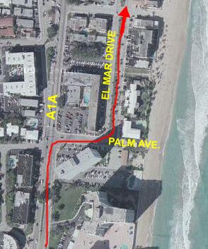
The bike ride continues up El Mar Drive, until it dead ends at a very large condominium building the occupies the area between A1A and the ocean.
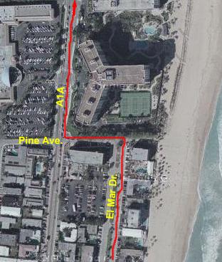 |
Right in front of you at the end of El Mar is a very large condominium. As you can see here, it has a pool AND tennis courts, and it is about fifteen stories tall. It is the southernmost of what is about two miles of one condominium or hotel after another between A1A and the beach. So once we hang a left on Pine Ave. and the a right on A1A (usually called Ocean Blvd. in whatever town it is going through), we will be on A1A for quite a while. Fortunately, we pick up a wide bike lane here, so even if there is a lot of traffic, the only thing we have to watch out for are people turning into or out of the condominiums and hotels.
This is another nice stopping place, because in the shopping center on the northwest corner of Pine Ave. and A1A there is a Baskin-Robbins store.
 |
Along this part of the route there are, for the most part, condominiums and hotels between A1A and the beach. There are some new buildings being constructed in this area on the sites where older, low buildings have been demolished. There are a couple of chain hotels, such as a Ramada Inn, that apparently found themselves on too valuable a piece of property. Rather than rebuild a new, fancier hotel, they've chosen to sell out to a developer.
On the west side of A1A, there are mostly residential neighborhoods- many with canals- that front on the Intracoastal. Right along A1A, they are condominiums rather than single-family homes.
There is a bike lane here, so the riding is safe and easy.
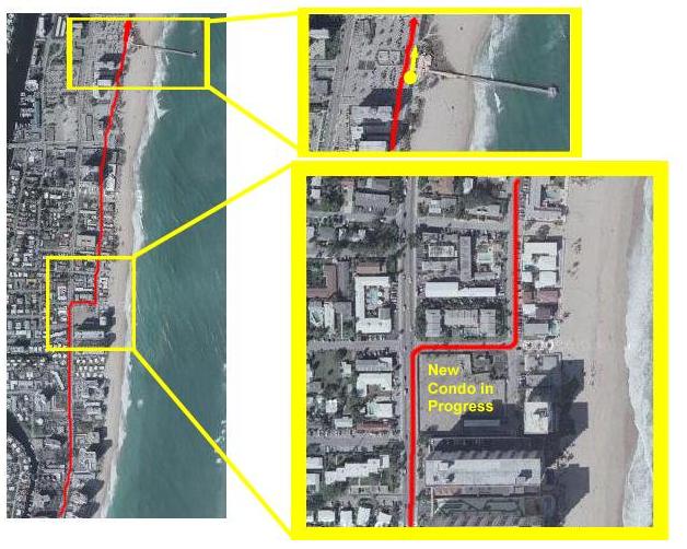 |
The lower inset shows where we can make a right turn to again get close to the beach- right at the corner where a building was demolished last year and now a tall, new condo is going up. The sign says 200 residences, which would make it at least 20 stories tall. As of this writing, it is well underway. A left turn puts us on Briny Avenue, which runs right along the beach through Pompano.
This an older section of the Lauderdale area. The condos are older and smaller, for the most part, and there are a number of private residences on the beach south of Atlantic Avenue. At Atlantic Avenue, there is a parking area for the beach, and then north of that there are no private buildings between Briny Avenue and the ocean. This is the beginning of the area properly known as Pompano Beach. Over on A1A, there is a lot of development going on, with most of the land on both sides of A1A north of Atlantic being cleared for new condos or apartments. I think that the kind of picturesque, beach community vibe may be going by the wayside.
|
|
Miles 10-15: Pompano Beach to South Deerfield Beach
 |
Along the way, there will be some excellent ocean views as well as a tour through one of the neighborhoods where the "other half" live.
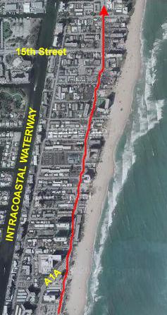 |
The stretch up to 15th Street is not very long, and there is a bike lane, so traffic isn't a problem. Like many areas in South Florida, there is a lot of building going on here. In the last few blocks before 15th Street and for a block or two after, there is one condo project after another going up; a couple of them have signs declaring that the price range will be from "the high $900,000s" (which means that anything but a unit with no view will cost you upwards of $1 million). I suppose they'll be nice, but I don't know how they could be THAT nice.
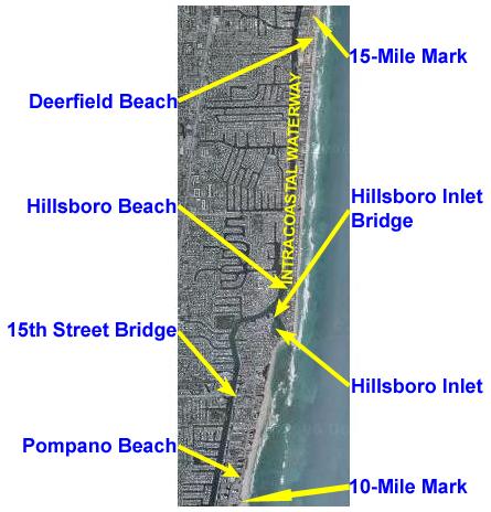
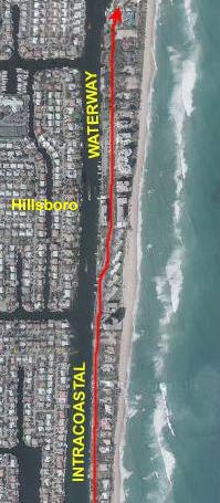
15th Street is one of the major streets that cross the Intracoastal; so many people leave in the upper end of Pompano Beach and across the inlet in Hillsboro that there needs to be an evacuation route somewhere north of Atlantic Ave., and this is it.
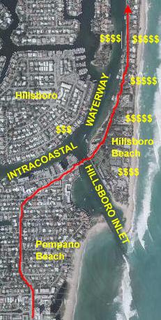 |
The Intracoastal Waterway wouldn't be what it is if there weren't outlets to the ocean every so often. Everglades Inlet, right in Fort Lauderdale, is one such outlet, and it serves the entire area from Hollywood up to Lauderdale-by-the-Sea. The next inlet heading north is this one, and every one from Pompano through Hillsboro and South Deerfield Beach uses it. (The next one north will be at Boca Raton.) Wherever you find these inlets, you will also find pricey real estate, because the people with the big boats don't want to have to go far to get out to the ocean.
At the drawbridge over the Hillsboro Inlet, there is a newly-renovated park and pier system on our right, and a couple of tall condos and some restaurants and shops on our left. Underneath the bridge and across the Intracoastal from where we are riding is the town of Hillsboro proper and, at least from what I can see of the houses lining the Intracoastal, it is a pretty exclusive place to live. There is always a lot of traffic going in and out here, so it is a good place to stop and take in the boating scenery.
Once you cross the bridge going north, you are in the town of Hillsboro Beach, and the homes here rival anything you might find in Biscayne Bay in Miami, Huntington Beach in California or Highland Park in Dallas, for that matter. The homes are all to your right, and, beginning very shortly into Hillsboro Beach, the lots run right across the island. As you are pedaling north along tree-shaded A1A, on your left you can see the large boat docks and boats that belong to the houses on your right. The houses are all very secluded for the most part, and only when there is a new one being built can you see what they look like, the foliage is so luxurious. If the town of Hillsboro gets three dollar signs, then this area must get five. A few years ago when I was biking along here, I noticed that there was a home lot for sale, so I took out my cell phone and called the Realtor. "It's really a prime piece of property," I was told, and "a steal" at $2.7 million. Gee, it's humbling to know that even if I could afford the lot, I certainly couldn't afford to put anything on it! The houses are all very, very nicely-done, as well they should be.
 |
 |
I hope you've noticed in all the pictures so far how built-up the area along the Intracoastal actually is. Just in the pictures you've seen so far, you've seen easily a few tens of thousands of homes and condos. And it continues this way for miles inland and for at least eighty miles north of where we are now. Incredible.
We continue north on A1A to the top of the left-hand aerial view, and come in again at the bottom of the right-hand one. The northernmost part of Hillsboro is again large condos, and then you cross into Deerfield Beach, always paralleling both the Intracoastal Waterway and the seashore.
Our next milestone is just outside the top of the right-hand aerial view.
 |
|
|
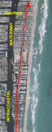
Miles 15-20: South Deerfield Beach to Gumbo Limbo
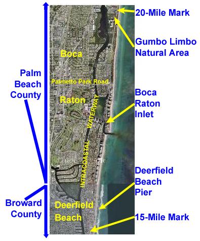 |
This fourth five-mile segment begins at the southern boundary of Deerfield Beach on A1A, and includes a ride off A1A and up the oceanfront to the Deerfield Beach Pier. There, the bike route rejoins A1A and continues north out of Broward County and into Palm Beach County (of 2000 Presidential Election Fame). Crossing into Palm Beach County, the route follows A1A and enters Boca Raton.
Continuing north, the route crosses the Boca Raton Inlet Bridge, and then continues straight north on A1A. The route crosses the intersection of Palmetto Park Road (another evacuation route) and follows A1A northward.
The route passes the Gumbo Limbo Natural Area and the section ends just a few hundred feet north of that nature center.
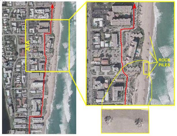 |
After biking north on South Ocean Way for a few blocks, you begin to see piles of rocks about every 100 feet along the beach, and you can see them here- those little dots near the edge of the water. They are actually about eight feet high, consisting of piled chunks of cement and rock. I can only imagine that they must be to forestall beach erosion, but how they do that is a bit beyond me. They are fun to climb on, though, but only when the lifeguard is not present.
A ways up South Ocean Way there is a beachfront condominium that was there before the street was upgraded, and so it retains its on-the-beach status as South Ocean Way goes around it and then continues north.
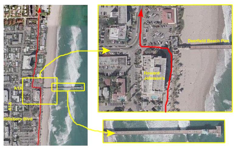 |
A few blocks further north and we reach Deerfield Beach Pier, which marks the northern end of the renovation of the beachfront. Fred and I have been out on the pier a couple of times; there are some excellent views up and down the beach from there. Actually, on a good day, you can see the high-rises of Fort Lauderdale to the south and of course Boca Raton to the north.
At the corner by the pier, the large building is a Howard Johnson's resort, which includes a restaurant that Fred and I have stopped at a couple of times. It is also fortunate that, right across the street by the entrance building for the pier, there is one of the most welcome cold-water fountains along the entire trip. Turning the corner by the pier, we rejoin A1A, and then turn right again and head north. Just as we turn north, we pass Mulligan's Restaurant on the left. It is a chain, but they have good food; Father Guy ate there with us the last time he was down to visit.
Oddly enough, there is no bike lane along this stretch of A1A, and I am not sure why, we don't get it back until we cross into Boca Raton and Palm Beach County. I am also not sure why the county line seems to be a boundary between two different kinds of aerial views. The views within Broward County seem to be a bit sharper but have less color; the views north into Palm Beach County seem a bit less sharp but with enhanced color.
 |
 |
Also, it does seem as if the buildings and houses are all a couple of notches above those in Deerfield Beach, perhaps because Boca Raton is such a toney place to live. On our right as we bike north, there is one large condominium after another, with names that start to run together after a while. The condos on the left (west) side of the road are all much lower and more spread out, but they seem just as nice. Behind them are single-family homes, which get nicer as we go further north.
But this mile and a half is basically a straight shot north.
 |
 |
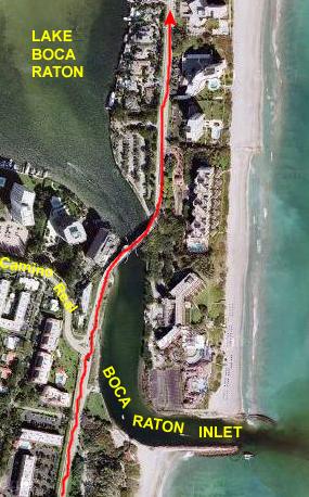
Boca Raton Inlet is the outlet from Lake Boca Raton, which is really just a wide place in the Intracoastal Waterway. The interesting thing, which you can only really see in an aerial picture like this one, is that the Intracoastal seems to be a lot dirtier than the ocean itself. The reason for this is probably obvious. There are so many boats plying the Intracoastal Waterway that the oil and exhaust that they put into the waterway has really polluted it a great deal. The water doesn't look to bad when you are on it, but as soon as you get out into the ocean, you can really tell the difference. Look at the color of the water that is flowing out of the inlet into the Atlantic. It almost looks like the outlet from a chemical plant or something like that.
 |
The barrier island is quite narrow here, just wide enough for A1A and a row of buildings on either side. This is mostly due to the fact that Lake Boca Raton is off to our left, and it is fairly wide here, cutting into the available space on the barrier island. As we pedal north, though, we come to the end of the lake as you can see in the picture at right. Note all the homes along the lake shore and the boat docks that each has. Those boats, coupled with all the thousands more on the finger islands throughout the area are, I suppose, what make the water flowing out from the lake into the ocean so dramatically different.
Soon, we cross Palmetto Park Road, another evacuation route from the barrier island. It crosses the Intracoastal off to the left, and actually leads into the center of the town of Boca Raton. We continue north, however, and beginning here with the park that is across from the intersection on the beach side of A1A, the land between A1A and the ocean is undeveloped- at least for a stretch. You can see the park road through this dark green area. This is one of the few public beaches here in Boca Raton.
 |
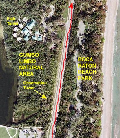 |
This being a chronicle of a bike ride, I won't delve deeply into what's here. But the museum buildings hold exhibits of local flora and fauna, and there are some movies and things describing the area. In the back area are five large aquariums that hold a variety of fish and amphibians. You may have seen pictures or movies of them earlier in the album.
There is also a very large natural area that has a raised wooden walk that leads through it to a five-storey wooden observation tower, from the top of which you can see up and down the Intracoastal from Highland Beach to Boca Raton. At the south end of the natural area, the walkway leads across A1A to a continuation of the walkway along the oceanfront.
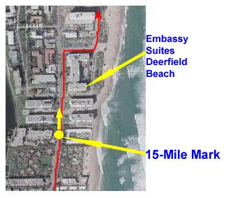
Today, however, I have ridden right past Gumbo Limbo, heading towards the 20-mile mark.
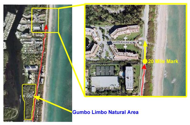 |
The 20-mile point was reached just before the condominium complex shown in the inset picture. I stopped at the point marked by the yellow dot, and took the picture shown here looking in the direction of the yellow arrow.
|
|
Then it was off on the next leg of the bike ride.
Miles 20-25: Gumbo Limbo to Delray Beach
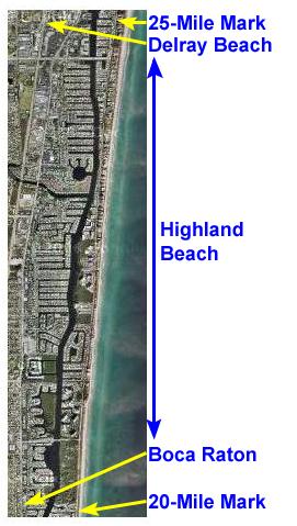 |
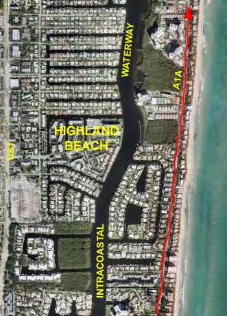
The next 5-mile stretch of my bike ride began at the 20-mile mark just north of the Gumbo Limbo Natural Area, in the northeast corner of Boca Raton.
Crossing the next major east-west street took me into the town of Highland Beach. All the way through Highland Beach, the road and scenery were much the same. On the right (the ocean side) there were, for most of the way, either large private homes or condominiums of varying sizes. Occasionally, there were areas too narrow or sandy to build on, and these were left open.
On the left side of A1A, there were homes, condominiums, apartments and a shopping area or two. I also passed a number of small parks.
As I went north, the area between A1A and the beach widened some, enabling developers to build larger condos or small home developments.
Crossing yet another evacuation route, I found that it marked the boundary between Highland Beach and Delray Beach, and it was just inside Delray Beach that I reached the 25-mile point in my trip.
While there wasn't much spectacular or interesting in this section of the trip, let's take a closer look anyway.
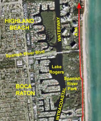 |
Spanish River Blvd. is the dividing line between Boca Raton on the south and Highland Beach on the north, and is another of the evacuation routes linking the mainland to the barrier island that I am riding on.
Crossing into Highland Beach, I am back in the familiar mode of condominiums and homes, sometimes on one side of A1A or the other, but oftentimes on both.
 |
One of the reasons that A1A can be so scenic is that all (or most of) the businesses are located on the other side of the Intracoastal Waterway along US1 (Federal Highway). The land on the ocean side of the Intracoastal is simply too valuable to use for commercial applications- except for the occasional small shopping center (since it may be quite some distance to the next bridge, north or south, that crosses the Intracoastal). US1 is also, for the most part, paralleling both A1A and the seashore.
But neither road is good for long-distance north-south travel; both are entirely too slow. To go long distances, one uses Interstate 95, which is about two miles west of US1 most of the time.
You can see that I am going in and out of developed sections- sometimes there are homes and sometimes condos or other tall buildings. Until I saw this picture from the air, I had no idea that the development built on the islands shaped like an "H" (for Highland Beach?) was even there.
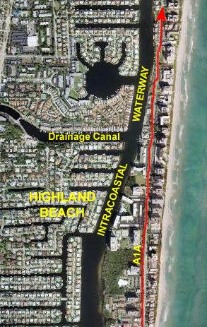 |
Although I could not see it from my ride, about in the middle of Highland Beach there is a canal that goes west from the Intracoastal Waterway. This is one of a number of such canals that criss-cross the area from Miami to Palm Beach. The land to the west is extremely low, and it is built up all the way to the Everglades. No storm water system known to man could possibly drain such a large, flat area after some of the rains that occur around here, so these canals were built to help. Some of them are navigable, but you can only go so far as the first fixed bridge, which usually isn't very far. But down here, near the ocean, these canals allow boat access to about a mile of homes and condos. Not for large boats, certainly, but for 20-footers or less.
Looking down from the air, I continue to be impressed with the sheer expanse of canals and homes; I wish I knew how many there were. And I am also amused by the creativity that is sometimes taken in the way they are laid out, such as the round lake with fingers, looking like a drawing you might see on a Mayan building.
But I didn't see any of this as I rode.
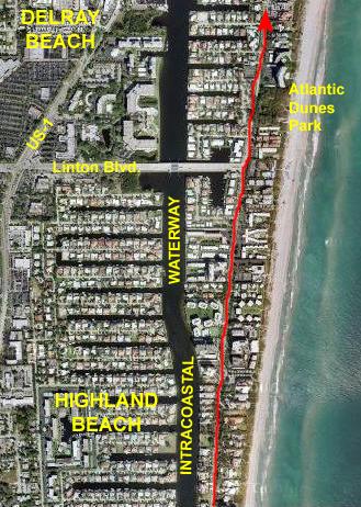 |
Just inside Delray Beach, I passed Atlantic Dunes Park, which had a nice boardwalk and views of the Atlantic Ocean.
 |
|
|
Miles 25-30: Delray Beach to Boynton Beach
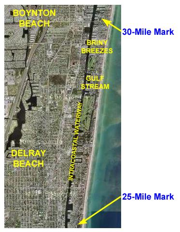 |
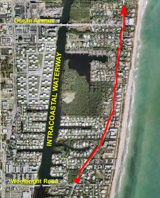
From the 25-mile mark, the next section continues to follow A1A as it runs north on the barrier island, paralleling both the Intracoastal Waterway and the beach.
Entering Delray Beach proper, A1A becomes a beachfront street, with all the development on the west side, and continual beach access on the right.
Passing out of Delray Beach, A1A goes past two famous golf clubs- Gulf Stream and St. Andrews- as well as Gulf Stream Park.
The small town of Gulf Stream is followed by the even smaller town of Briny Breezes, and then, very quickly, I biked into Boynton Beach.
Since it was lunchtime, I took a detour to get some lunch before returning to the beach and A1A and heading just a block further north to the 30-mile mark.
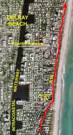 |
All along this stretch through Delray Beach, there were a lot of people out at the beach, and parking places seemed to be at a premium. There is also a nice, broad sidewalk, plenty of benches and things, showers and water fountains- all the things the beachgoers need.
The big difference between here and Fort Lauderdale, though, is that the beach here is lined with a thicket of sea grape and other salt-tolerant plants. Each of the pathways that leads down to the shore has to pass through this thicket, and the thicket is about ten feet high and at least that thick. So you really can't see much of the beach from the sidewalk, except if you look up or down the beach a ways. It's really kind of interesting, and I assume that it is natural growth rather than something planted. It does give a secluded feeling to the beach itself.
In the center of Delray Beach is Atlantic Avenue, another of the major evacuation routes. Atlantic Avenue goes inland, over the Intracoastal and through the downtown area of Delray Beach. It crosses US-1 and interchanges with Interstate 95, and then continues west all the way to the Everglades. It is one of THE major east-west thoroughfares between Boca Raton and Palm Beach. The first time I drove south on Interstate 95 to get to Fort Lauderdale, I got it confused with the major street with the same name that runs from Pompano Beach out west to the Everglades down in Fort Lauderdale. I remember getting off and wondering why I couldn't find anything familiar, until I consulted a detailed map to find out I was still 20 miles from Fort Lauderdale!
It was getting on towards lunchtime and, while I don't usually eat much lunch, all the bicycling had made me hungry and very thirsty. Had I known, I might have taken Atlantic Avenue in to US-1 to find a place to eat, but I had kind of planned on stopping in Boynton Beach, so I continued biking up A1A along the beach, sometimes on the sidewalk, sometimes in the bike lane.
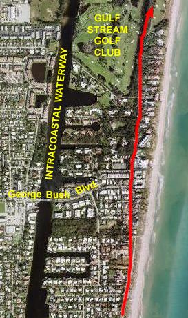 |
After a bit, I ran out of bike lane again as A1A turned slightly away from the beach, and I started to see homes and condos again between myself and the beach. I stopped at the corner of George Bush Blvd. (I certainly hope it is named for the first one) and A1A to ask a guy from Florida Power and Light who was working on a traffic signal which street I should take in Boynton Beach to find someplace to eat. We got into a discussion and the topic of George Bush naturally came up. When I gave him a chance to express an opinion, I found that while he didn't think the father was particularly bad, he disliked the current President a great deal. My only comment was that, while I was from Texas, I didn't much care for him either.
North of George Bush Blvd., A1A got a lot prettier and shadier as it went through some large stands of what was eithe salt cedar or some kind of cypress. The trees were particularly thick and shady along side the Gulf Stream Golf Club.
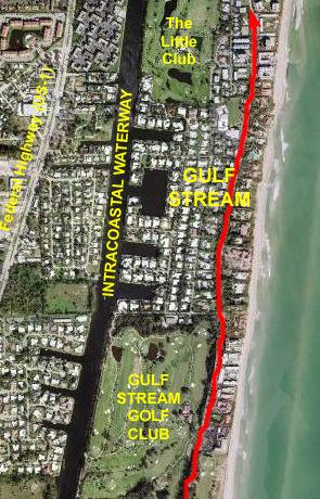 |
I continued north, past another country club that I couldn't see from the road. (I assume that "The Little Club" is very exclusive, as wealthy people typically talk about their "little" place in the country when in reality it's a 10,000-square-foot mansion.)
As has been the case throughout the bike trip, US-1 is paralleling me on the other side of the Intracoastal and here, like much of its route in Fort Lauderdale, it is divided with a median.
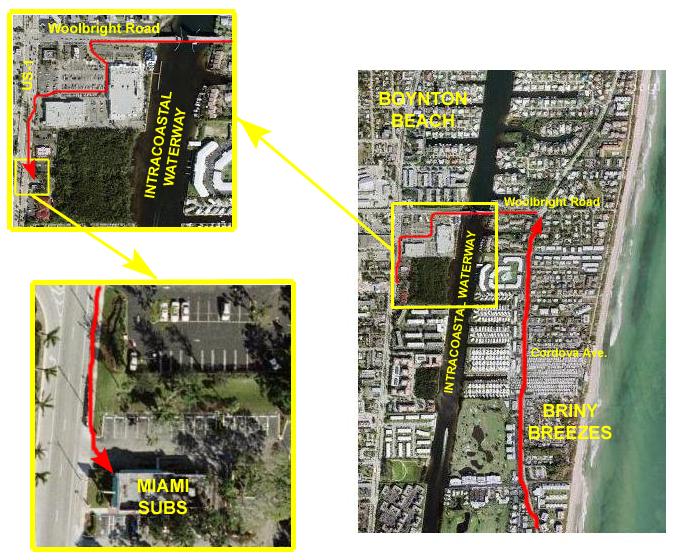 |
I stopped by a service station right across A1A from Cordova Ave. in Briny Breezes to ask the man working outside where along A1A I might stop for lunch. He mentioned a small, local cafe right across the street, but when I indicated that I'd like also to get the biggest soft drink I could find, he told me that if I just went north a half mile to Woolbright Road, and then went west across the Intracoastal, I'd be right in the thick of "franchise city" along US-1.
I hadn't thought that US-1 was quite so close, but that sounded like a good idea. I turned left at Woolbright Road and went over the Intracoastal on a broad, new drawbridge. Just on the other side, there was a shopping center with a Publix and a bunch of other stuff, but it was the billboard for Miami Subs that I saw ahead of me that set my route. I went through the parking lot and over to US-1, went south for about three blocks and found the Miami Subs.
Fred and I have eaten at one near Ron Drew's house, and I knew their food was pretty good (and that they had great fries); that's what made me bypass a Wendy's and a McDonald's. I chained the bike up out front and went in to have lunch.
Actually, I sat inside for almost an hour, enjoying the air conditioning and drinking one cup of soda after another. When I left, I felt rejuvenated and ready for another 30 miles. I retraced my route up US-1 and back across the Woolbright Road bridge to the intersection with A1A and my next milestone.
 |
I parked my bike by the corner and took my usual picture and movie, both at the spot marked by the yellow dot and both looking in the direction of the yellow arrow.
|
|
Miles 30-35: Briny Breezes to Manalapan
 |
I headed north along A1A, with the typical scenery of condos and homes on either side of the road.
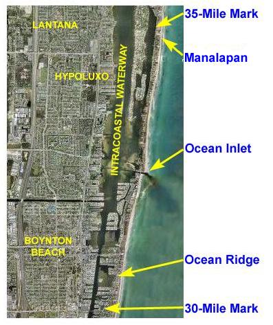
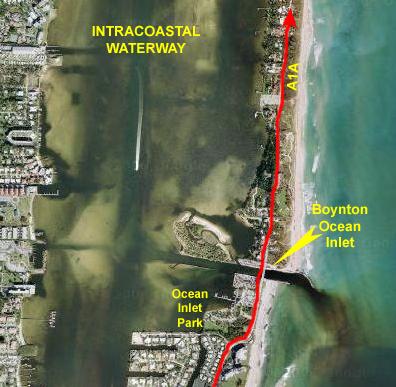
Midway through the segment, I came to Ocean Inlet, a very small town named for the inlet that has been created through the barrier island and into the Intracoastal Waterway. If this entry had not been made available, boats would have to travel about ten miles in either direction to find an outlet to the ocean. Once again, I was impressed by the difference in water quality between the ocean and the Intracoastal.
Continuing north, A1A hugged the Intracoastal for the most part, allowing the creation of communities right on the beach. Views to the Intracoastal were limited, but halfway between Ocean Inlet and Manalapan began a long peninsula of homes in the middle of the Intracoastal Waterway.
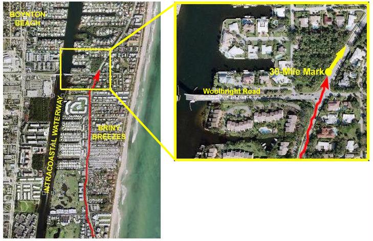
Finally, just through the town of Manalapan I came to the 35-mile mark in my trip.
 |
After taking my picture and movie at the 30-mile mark, I hopped back on my bike and started pedaling north on A1A.
For the next mile, there were homes and some small condominiums on both sides of the road. This particular area doesn't have the density to justify the construction of any high-rise buildings. There seemed to be quite a few sites that could easily be turned into such complexes, and there are certainly enough services to support them on the other side of the Intracoastal, but our location halfway between the attractions of Fort Lauderdale and the cachet of Palm Beach seems to have meant that this area will only get built up as development works its way from the north or the south.
Still, though, the homes along this stretch were very nice, as well they would have to be given the cost of the building lot they are sitting on. I had a bike lane again or, if not that, a nice sidewalk, so the cycling was easy and safe.
 |
Just north of this public beach was what appeared to be a natural area of some kind. It seemed to be prime building property, and in fact all around it (except for the public park to the south) everything WAS built up. I actually didn't see any signs, but when I was preparing this narrative and checking the maps, I found that it actually WAS a natural area- preserving a stretch of the natural seashore.
I continued north for another half mile along A1A (as usual actually called Ocean Boulevard).
 |
This inlet, like almost all the others that cut through the barrier island, is artificial, constructed at the same time the Intracoastal Waterway itself was defined and constructed.
It is only from the aerial view that we can see some of the topography of the actual Intracoastal Waterway- things I could not see from the ground. From my vantage point, the Intracoastal at this point looked like a wide lake, and I assumed it was basically the same depth all the way across. But not being a real boater, I didn't realize that the Waterway would only be dredged in certain places to allow the big boats access up and down, and inland to the marinas and docks and out to the ocean itself. In the map at right, the darker areas are, of course, the dredged ones. This view offers an excellent example of what boating in the whole South Florida area is like- it is a matter of staying where there is enough depth for your size boat. I can't tell exactly how big the boat heading south is, but from the length of the wake, and comparing it to some of the buildings, I'd say it's between 40-60 feet long, and at that length it needs to stay in the dredged area, which is exactly what it is doing.
This view also displays again the apparent difference in the quality of Intracoastal Waterway water and ocean water. Crossing the inlet bridge, I found myself on a very narrow portion of the barrier island. There were a few homes on the north side of the bridge, but most of the small amount of land was undeveloped. A bit further north, there were homes again, but only on the Intracoastal side of the highway. It was pleasant to be able to see the ocean continually as I headed north.
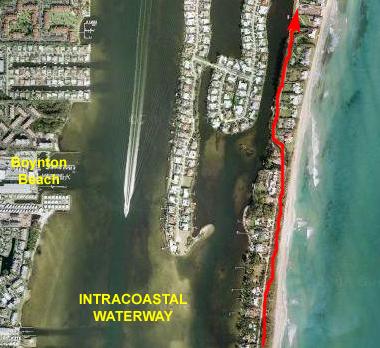 |
Then, A1A switched to the Intracoastal side of the island, and I lost my view of the ocean. I gained views of even nicer homes, though, and I could see the artificial islands built in the Intracoastal Waterway so that more waterfront homes could be constructed. Some had boat docks, some didn't.
Although I couldn't see past those homes to the middle of the waterway while I was on my bike, this aerial view shows again how the waterway has been dredged for boat traffic.
Theoretically, I am still in Boynton Beach, which crosses the waterway to the ocean, but I am reaching it's northern border with the town of Hypoluxo.
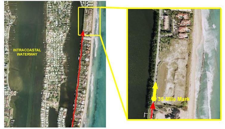 |
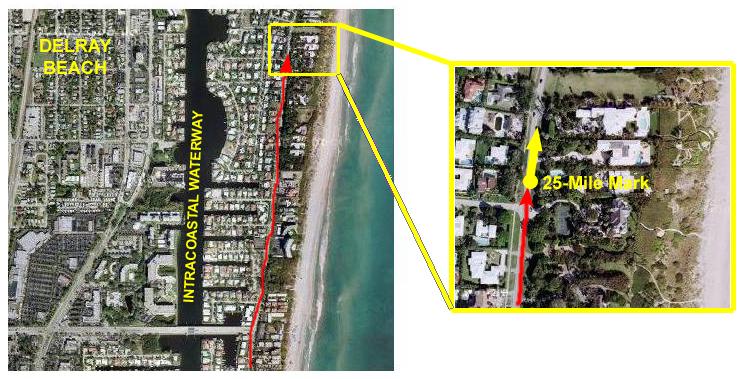
I hope to do about 60 or 70 miles today, and then the same amount back home tomorrow, so I guess I am about halfway. I am still on the barrier island between the Intracoastal Waterway and the Atlantic Ocean, and 35 miles has brought me alongside what appears to be a future gated community. If you take a look at the inset map, and then compare it to the picture I took at the spot marked by the yellow dot (viewable here), you'll be able to match up the wall in the picture to the same wall, seen from above, in the aerial view. This pair- photograph and aerial view- match up perhaps more clearly than any pair so far; there is little doubt as to exactly where the photo was taken. It looks, of course, in the direction of the yellow arrow.
|
|
Having reached 35 miles, it's time to head for 40.
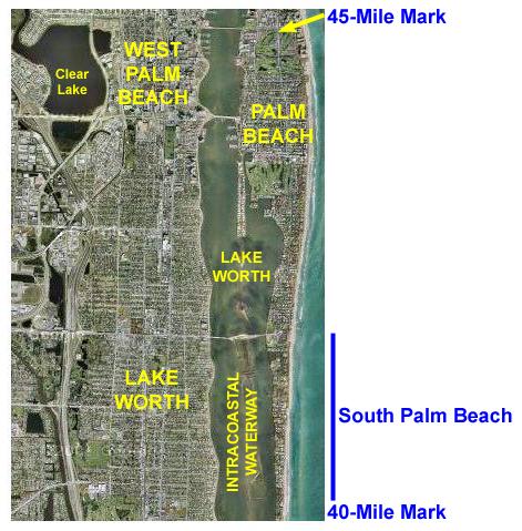
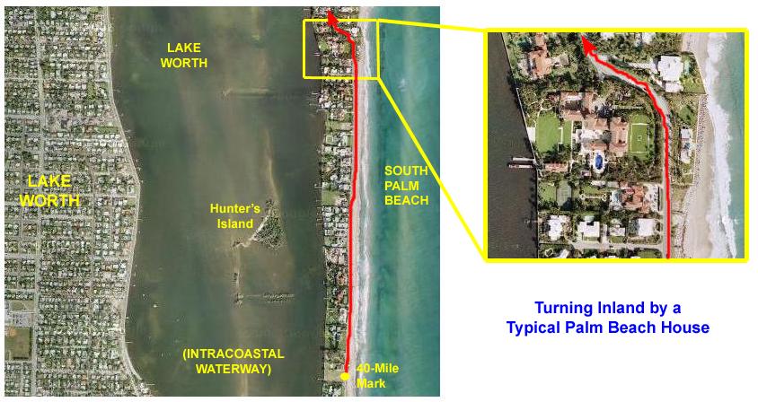
Miles 35-40: Manalapan through South Palm Beach
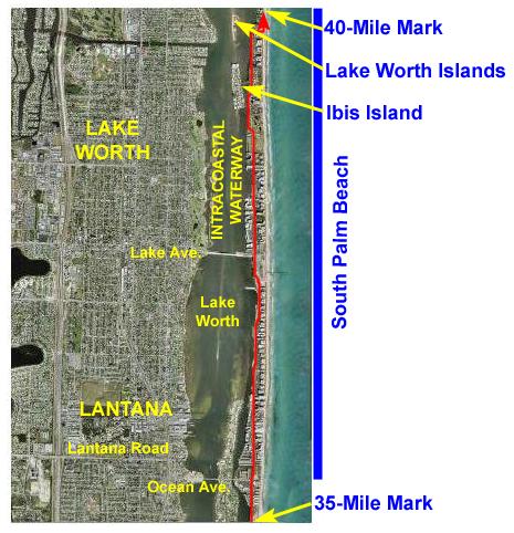 |
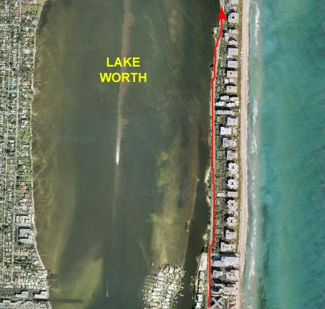
Just after entering South Palm Beach, the wide expanse of Lake Worth opened up on my left, and I soon found myself biking through a narrow park that lay between the lake and A1A. Since there were estates and houses on my right, I couldn't see both the ocean and the lake at the same time very often.
There was a very handsome bridge across the lake at, appropriately, Lake Avenue, which was also the dividing line, on the west, between Lantana and Lake Worth.
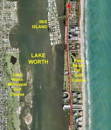
Continuing north, I passed some artificial islands built in the Intracoastal. The largest was Ibis Island, but there were also others. Near the Lake Worth Islands, A1A shifted to the east, so that the ocean was on my right and the homes and estates between me and Lake Worth on the left. It was along this stretch that I reached the 40-mile mark.
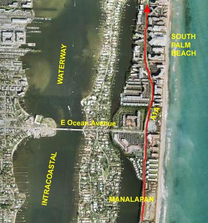 |
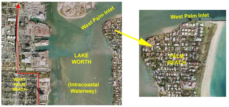
So, now I'm in the town of South Palm Beach, where I will be for quite some distance.
On the west side of the Intracoastal, the cities are different. Across the bridge on Ocean Avenue is Lantana, of course, but north of that is the city of Lake Worth. Also beginning at the Ocean Avenue bridge is the area of the Intracoastal Waterway called Lake Worth. As we've seen before, Lake Worth is just a widened portion of the waterway- not a body of water by itself. On the map here, I've labeled the water the Intracoastal Waterway, but on the next few maps I'll use the more correct name "Lake Worth."
Past Ocean Avenue, and into South Palm Beach, there was an area of condominiums and hotels and resorts, and very few private homes. Most of the private homes in this area were on the island in the Intracoastal, connected to the barrier island and the mainland by E. Ocean Avenue. I took a very short jog west to take a look at the island, and then continued north.
 |
Even though I had a good bike lane, I used the sidewalk through the park, as there was no one at all I was in danger of running into. As I pedaled along, I could see a bridge across Lake Worth up ahead:
As it turned out, this was the Robert Harris Bridge. This picture will give you a good idea of what this area all along Lake Worth was like.
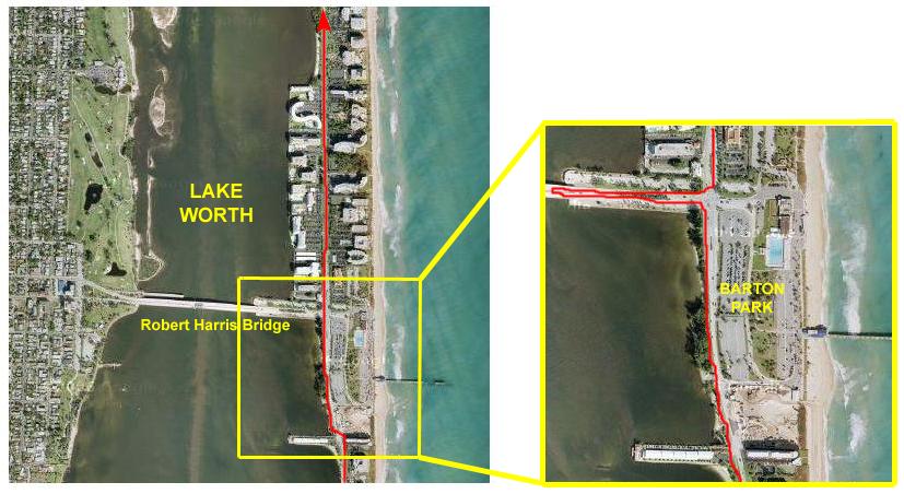 |
Just north of the park, the Robert Harris Bridge brings traffic from Lantana Blvd. across Lake Worth to A1A and the barrier island. When I reached that intersection, I took a jog out onto the bridge to take a look at Lake Worth. It looked just like the Intracoastal Waterway (which it is part of), only wider. I didn't see as many boats here as I am used to seeing along the waterway.
I came back to A1A and continued north, going first through an area of high-rise condominiums and then single homes.
 |
A1A cut right through the Palm Beach Par 3 Golf Course, and there were quite a few golfers (and quite a few golf carts) crossing the road back and forth.
Then it was just a short distance further to the Ibis Way, the sole road out to Ibis Island in Lake Worth. Ibis Island is a gated community, or I probably would have taken a ride out to the island to see what the homes were like. I learned later that it is almost a self-contained little community, with a few stores, a clubhouse, some homes and some condominiums.
I continued up A1A, past Phipps Ocean Park.
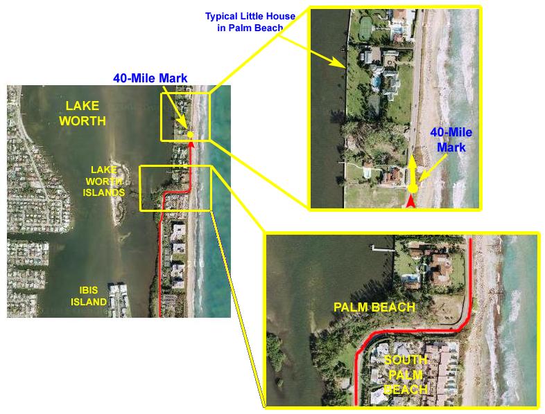 |
I had continued north on A1A to a point where the road turned sharply, went directly to the beach and then headed north again. There was a sign here welcoming me to Palm Beach, and, as I expected, the houses took a dramatic turn for the more grandiose. I have marked one of the typical home compounds on the inset map showing the 40-mile mark, and I have shown the detail of the turn into Palm Beach on the lower inset map.
|
|
Now I had quite a distance to go through Palm Beach itself- a city only somewhat smaller than Fort Lauderdale, so I assumed that the next ten or fifteen miles along the oceanfront would be all inside Palm Beach. As it turned out, however, A1A did not simply follow the ocean northward, for here, at Palm Beach, there is another inlet like Everglades inlet in Fort Lauderdale- one that a highway does not cross. A detour will be required, but I hope to get back to the oceanfront before too long.
Miles 40-45: South Palm Beach to Palm Beach
 |
The route continues along A1A which, in South Palm Beach, is hugging the ocean, sometimes jogging inland one block to allow for oceanfront homes. When I can't see the ocean, I can usually see the Intracoastal Waterway.
About two miles into the segment, I will cross into Palm Beach itself, continuing up the ocean until I turn inland about four or five blocks.
Then A1A continues on into the center of Palm Beach.
 |
About a half mile up the road, A1A turned inland towards the Intracoastal Waterway- as it often has to allow homes to be built directly on the ocean. I have no idea whether some of the homes were here first or not, but there doesn't seem to be any rhyme or reason as to when the road turns. For this particular turn, I thought you might be interested in seeing, from the air, one of the typical little beach cottages that can be found in this part of Palm Beach, and certainly along the ocean. If you can afford to buy a building lot in an area where beachfront property is so scarce, I guess you can afford to put up a home to match- and this one certainly does.
I followed the A1A curve inland, and now had beautiful homes on both sides for a ways.
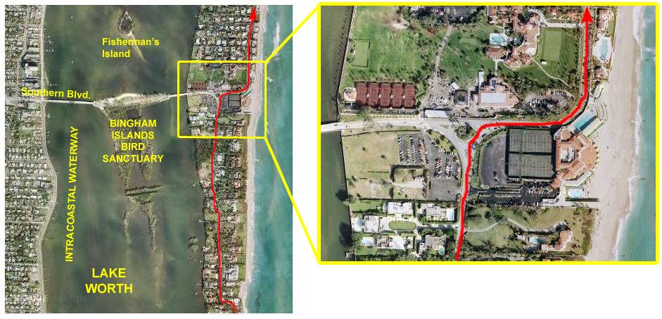 |
As I went around the little traffic circle at the intersection, I could see the Intracoastal Waterway and a bridge out to an island, so I took a very short detour to see what I could see. At the edge of the Intracoastal, I could see a sign for the bird sanctuary that occupies some islands in the middle of the waterway (which is, of course, still Lake Worth). I thought that biking out to the islands and looking around might take more time than I had today, so I thought I might take a look on the way back.
Back at the circle, I found that in the southeast corner, on the beach, was a huge hotel/resort complex- the Palm Beach Oceanside Hotel, if I recall correctly. On the other side of A1A there was a wall all the way around the curve to the north, and I couldn't really see behind it. When I got around the curve, though, I could look through the gate and I saw one of the largest homes I'd seen so far. I'm pretty sure it's not Mar del Lago (the Trump place), but it certainly looked like it could be. Until I saw this aerial view, though, I didnt realize how big the compound was- it extended all the way across the barrier island. And even as big as it is, it looks as if they are adding on!
Then it was back to the oceanside and continuing north.
 |
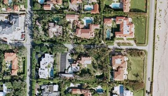
I thought you might want to see some detail of the homes in this area, so I have included a small view of some of them below:
 |
 |
Just after I crossed into Palm Beach itself, A1A became an oceanfront street, a nice sidewalk appeared on the ocean side and the road widened to allow parking on both sides.
What I find interesting in all of these aerial views that you've seen is that I can trace my route so precisely. I can even see from the air the exact spot where I stopped on the ground, and I have such a picture here.
I've taken a very small portion of the aerial view of this part of the trip, and I have blown it up to show the detail. The large-scale aerial view at left is about a mile from top to bottom, while the portion covered by the inset picture is about 300 feet north to south.
I had stopped to take a picture at the spot marked by the yellow dot, looking in the direction of the yellow arrow. Notice that to the left of where I must have been standing, the aerial view shows you that the pavement has been striped so that a parking lane can be created, and the striping funnels the traffic to the left around the parking lane. You can see the first few parking spaces as well.
Look at the actual picture I took. You can see the same striping and the same parking spaces, although this time you are looking at them from my actual vantage point on the ground. The only difference, of course, is that the pictures were taken at different times, so shadows, movable objects (and sometimes even stationary ones) may be different. In fact, in the aerial views I've used here, there have been times when the aerial view shows a vacant piece of land where now there is a building, and I can judge how long ago the aerial view was taken based on clues like that. Still in all, I think it's pretty amazing- even more so when you've actually covered the route on the ground.
|
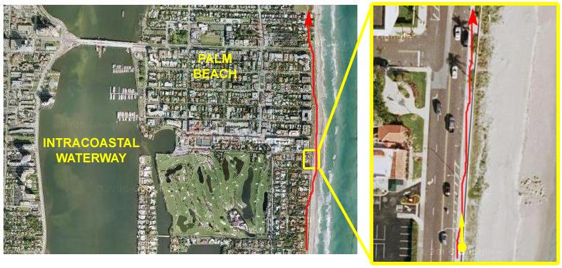
Now that I am biking through Palm Beach itself, the homes have become more and more grand- particularly along the ocean. Palm Beach has that reputation as one of the playgrounds of the wealthy although, like any city, it's really only certain sections, like this one, that are at the upper end of the scale. In any event, the homes were lovely to look at and they certainly had great views. I crossed Royal Palm Way (which leads back to the mainland over Lake Worth, and continued north, coming to a forced turn at Barton Avenue. (See the inset map.)
|
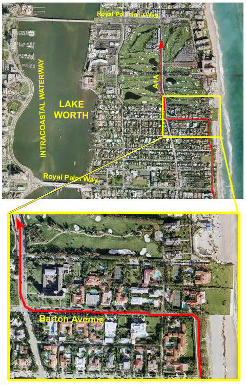 |
|
At Barton Avenue, I encountered something odd. The home right in front of me had extended its planted yard right down to the ocean, blocking the beach. I had no idea how they'd been allowed to do that, or why they'd chosen to do it, but it forced the oceanfront road to turn left and head inland. You can see the situation in this aerial view. Unknown to me at the time, there was another home to the north that had done the same thing. Was the beach private from this point onwards? I had no idea- I didn't think one could actually buy the beach itself. But, in any event, I had to make a left turn and head down a wide residential street. At the next corner there was a large church on my right, and the sign told me that I was back at A1A. I hadn't realized it, but about half a mile ago, when I bore right at an intersection to stay by the ocean, A1A had actually followed the left-hand turn, and this was the same street again. |
 |
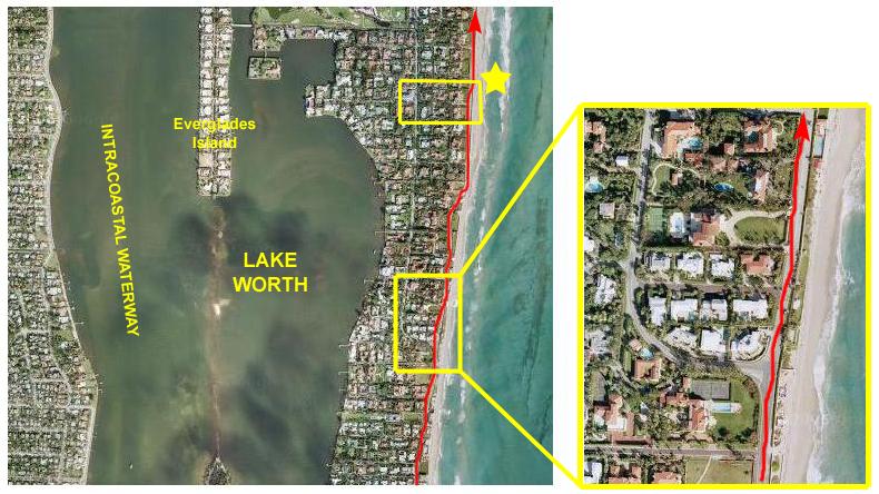
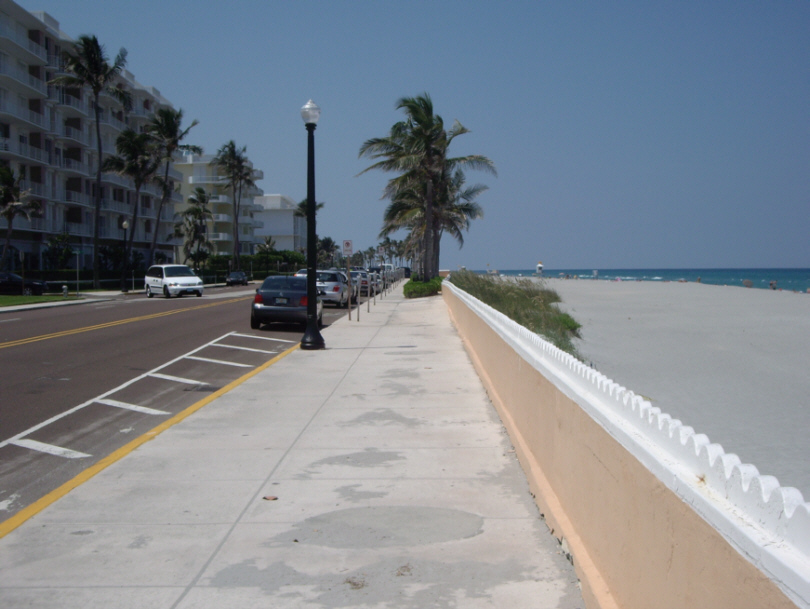
Only half a block before A1A turns west again on Royal Poinciana Way, my odometer told me I'd reached the 45-mile mark on my trip today.
On the inset map, you can see that I am stopped on A1A right next to the tennis courts at the Golf Club. I stopped at the point marked by the yellow dot, and took my picture to record this milestone looking in the direction of the yellow arrow; you can see that picture here.
I think this picture is interesting when compared to the aerial view. For example, in the picture, you can see that the street is bordered by a tall hedge of vegetation to block the view of the tennis courts. Also, you can see from the aerial view that the pavement changes color just north of where I am standing and, if you look closely, you can see that same pavement color change in the picture. You can also pick out the buildings and other items in the picture and see them from the air in the inset map.
|
|
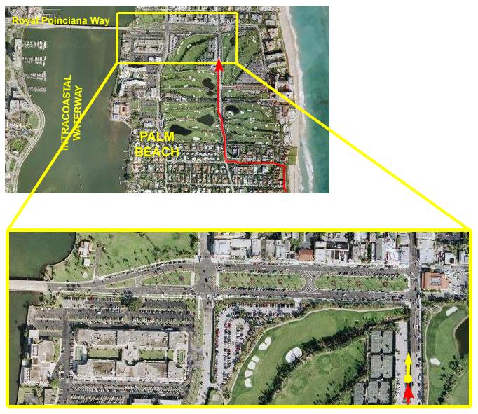
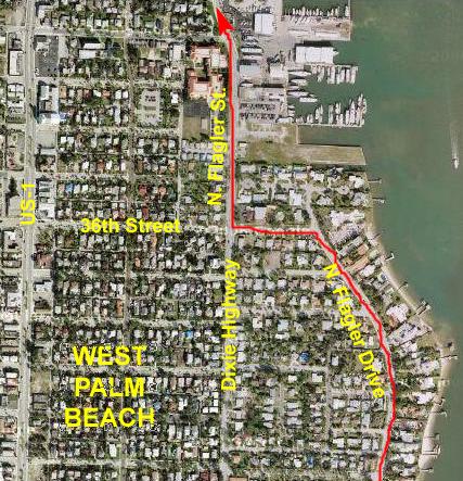
Miles 45-50: Through West Palm Beach to the Buie Bridge
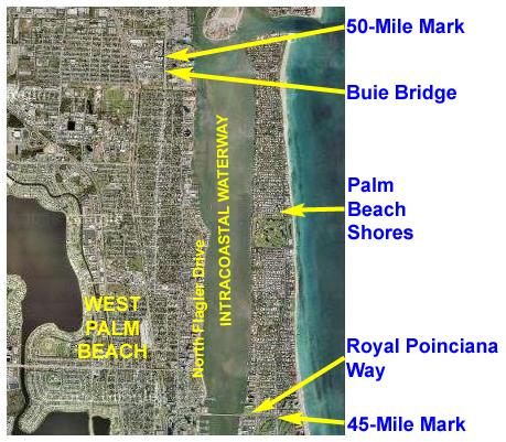 |
Beginning at my 45-Mile stopping point in Palm Beach, I just had to go a block or so north on A1A to Royal Poinciana Way where I could cross the Intracoastal into West Palm Beach.
Then it was a right turn onto North Flagler Drive and along the Intracoastal for about three miles.
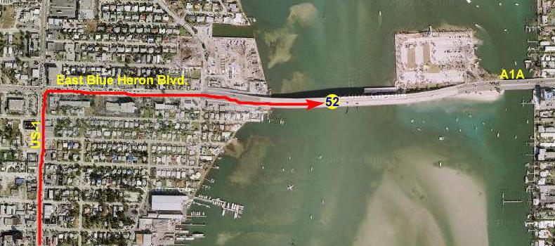
North Flagler finally turns left and ends in US-1 where the industrial area of North Palm Beach begins. US-1 will be my route north for a while until I reach a place where I can cross back over the Intracoastal to the beach again.
The 50-mile mark was reached almost exactly in the middle of the Buie Bridge, which spans an industrial/shipping area and waterway in North Palm Beach.
 |
At this point, A1A turns west. The reason it does is that about three miles north of this spot, the peninsula of land on which Palm Beach Shores is situated comes to an end at the Lake Worth Inlet. It is like the Everglades Inlet down in Fort Lauderdale- there are so many large ships that use the inlet that it would have been impractical to build a bridge high enough to cross it yet allow the ships to pass through. They could have built a drawbridge, but here the shipping is so frequent that traffic would have been continually interrupted. Finally, as is the case in Fort Lauderdale, so much prime beachfront real estate would have had to be sacrificed, on both sides of each inlet, that building the bridge would have been far too expensive.
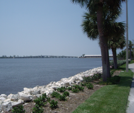
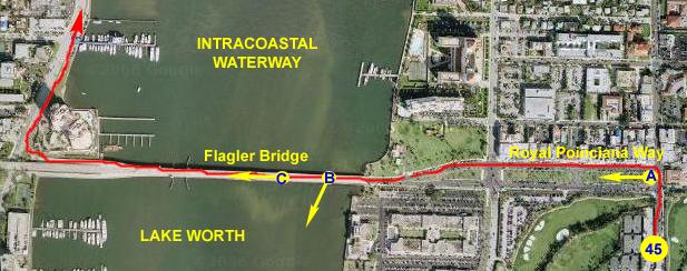
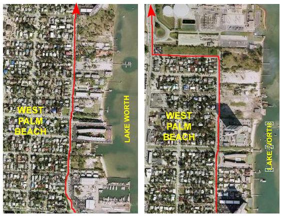
So, the solution in both places is to have A1A run to the other side of the Intracoastal, go a few miles north through Fort Lauderdale or West Palm, and then back out to the beach on the other side of the inlet. I turned left onto Poinciana Way and followed the park-like promenade (and biked in front of some pretty nice stores) to reach the Flagler Bridge over the Intracoastal and into West Palm Beach. I stopped at Point B to take a picture of Lake Worth and West Palm Beach and then I stopped again at Point C to take a picture looking west across the Flagler Bridge.
Then, I continued across the bridge and took the auto ramp down to North Flagler Drive. A1A actually goes a couple of blocks further west to join US-1 for a few miles, but I thought it would be more scenic to stay by the Intracoastal Waterway. I figured I could always cut over to US-1 if I had to. So I biked around a condominium complex and headed north.
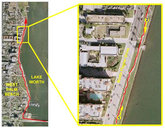 |
After I'd biked for a ways, I thought I'd stop and take a couple of pictures of the area. At the first stop, labeled with the yellow dot #1 on the inset map, I took a picture of the lakeshore along North Flagler Drive. If you look closely at the picture and compare it to the aerial view, you can pick out exactly which buildings are in the photo, and exactly where I was standing when I took it.
A bit further along the lake shore, at yellow dot #2, I took another picture, this time of downtown West Palm Beach looking back the way I have come. Again, it is pretty easy to match up the aerial view with the photo. Then it was onto my bike again.
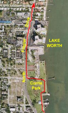 |
Pretty quickly, I came to Currie Park and rather than follow the street, I thought I would take a detour through the park. Unfortunately, I ran out of sidewalk halfway into the park, and had to head back out to North Flagler Drive anyway.
I continued up the street past the rest of the park, and now I wasn't on the lake shore anymore, as thee were condos and homes between me and it.
 |
At 36th street, the sign ahead of me said "No Outlet" and I noticed that there was a sign pointing left to North Flagler and Dixie Highway, so I turned left on 36th Street, then right again on North Flagler Street.
Dixie Highway merges here with North Flagler, I guess. Dixie Highway is the same road that continues all the way down to Fort Lauderdale (although it might not be continuous). It takes a disconnected route through Lauderdale, starting, I think, at Sunrise Blvd. It follows the train tracks north through the city, passing the new Home Depot, Peter Pan Diner, Ty and Scott's workroom and a few other places I go frequently. I have run across it up by Atlantic Avenue, when I was staying with Ron and Leroy and biked over to the ocean from their house. It's never a major road, like Federal Highway (US-1) is, but it is a major north-south street down there. Up here, it is, at least for now, again a residential street.
Pretty quickly after I turned north again, I found myself in a more industrial area. There were still some homes, but now there were marinas and some other commercial buildings.
 |
I continued north until I came to a dead end at what I could later see in aerial photos like these were shipping complexes here at the northern end of Lake Worth and near the outlet to the ocean.
I had to turn left and head over to US-1 to continue north to the next five-mile mark, so I did that and, after about three blocks, found myself back at the main drag of US-1. Here, I turned right (north) and immediately headed up onto the Buie Bridge.
A1A has been paralleling US-1 all the way from Fort Lauderdale but, until now, I have not had to actually ride along US-1. The main highway has never been too far from me; I had my lunch at the Miami Subs on US-1 in Boynton Beach. But I've always been able to return to A1A for the bike ride. Until now, that is.
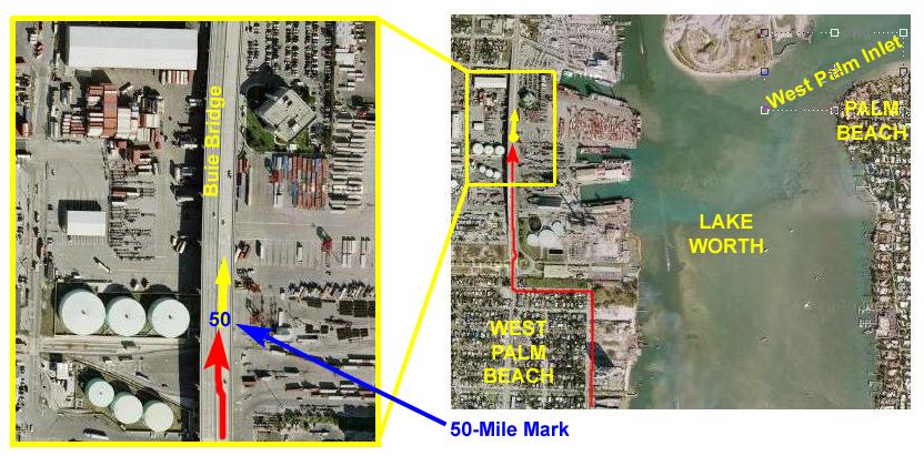 |
I confess that I'm not exactly sure why the bridge is here, since it does not span any kind of waterway. The only thing I can think of is that it would have been a mistake to divide the large shipping/port facility below with a major highway; there would have been way too much cross traffic and that would have caused unacceptable congestion on what is the major north-south road through this area. Interstate 95 is west of here, but it already carries all the long-distance traffic. People from the northern reaches of the Palm Beaches would not have found it at all convenient to go so far west to an already congested expressway just to drive the few miles necessary to get to work in West Palm or further south.
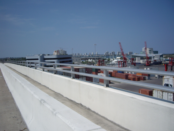
Whatever the reason for the bridge, traffic did move smoothly across it. It was very wide, and had a good bike/breakdown lane on either side. So I stopped at the top of the bridge and took my 50‑mile picture. I also took my 50-mile movie, both at the spot marked by the yellow dot and looking in the direction of the yellow arrow. You can watch it with the player below. I did not notice at the time that the movie ended before I was done- because the memory card had become full.
|
|
I also thought I should reward myself with another rest stop and a cold drink, so I planned to keep my eye out for another Miami Subs as I continued up US-1, looking for the point where A1A must leave US-1 and head back over to the beach.
The Next Five Miles
 |
Nearby, you can see the shipping facilities and the building that houses the port authority offices and some of the shipping company offices. But looking further, you can see the bridge that will lead from US-1, across the Intracoastal Waterway, and back to the beach. And you can also see more condos and apartments which, I assume are along the beach.
So I'm looking forward to getting out of the city and back to the beach, but first I have to get up US-1 to the turnoff.
 |
You can see in the inset picture that there has been a barrier island on the other side of Lake Worth as I have biked north, but that it ends almost due east of the Buie Bridge. There is a very wide opening to the ocean, and then the barrier island begins again. You can see the bridge to it in the picture above. So, that said, let's head off up US-1.
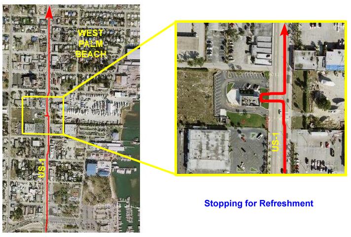 |
After just relaxing for a half hour, I got back on the bike and continued on up US-1. The highway was quite busy, but the four-lane road was wide with sidewalks so, although there was no bike lane, I didn't feel crowded by the cars.
I traveled up the highway for about a mile, and then came across the intersection with East Blue Heron Blvd. which was also A1A if you turned to the right. I knew that A1A would take me back to the beach, and I was looking forward to getting out of the city and back to a more scenic ride.
 |
That's when I got my surprise. I had thought to bring extra batteries for the little camera, but when I tried to take a picture and saw the "Memory Card Full" display, I realized that I had neglected to clean off the 256MB memory card before leaving Fort Lauderdale, and I knew that it was at least two-thirds full with old pictures and movies that I had not yet saved off.
My first thought was to try to find a computer store where I could buy a pack of CDs and perhaps borrow a display computer to transfer the files to a CD so I could take more pictures, but I had no idea where the nearest one would be, nor was I sure that I would be able to borrow a computer for the purpose.
One thing that I definitely wanted to be able to do on this bike trip was record my progress with pictures, and I just couldn't see going another twenty-five miles without being able to keep a picture and movie record. Perhaps I was being overly rententive, but I decided that I would end the northbound portion of the trip here, after just under 52 miles from my starting point.
Now, my plan had been, all along, to stay the night wherever I ended up and then bike back the next day. But when I started to think about it, I thought that since it was only mid-afternoon, and since it was summer and the light would be with me for at least another six hours or so, and since I knew the route back and since I wouldn't have to stop and take the time to take more pictures that I would just turn around and head back home today. Although I had traveled over 50 miles, I didn't feel overly tired out, and I thought I could make it back without much problem.
And so, reluctantly, I took in the view from the bridge and then turned around to head back to Fort Lauderdale, simply retracing the path I took to get here. So there won't be any more maps or descriptions, since you've already seen it all.
I headed back west to US-1, and then south across the Buie Bridge. I turned east on Flagler Boulevard/Dixie Highway, and took that all the way back into the middle of West Palm Beach. Then it was east across the bridge over Lake Worth, south through Palm Beach proper, and then east, following A1A to the ocean.
Then it was south for a long stretch along A1A all the way back along Lake Worth to Boynton Beach. By this time, I was indeed getting tired, and so I took the bridge at Boynton Beach back west to US-1 again so that I could relax for a while at the same Miami Subs I had lunched at four or five hours earlier. From there, I continued down US-1 into Delray Beach, and then took the Delray Beach bridge back to A1A and the ocean.
From there, it was another long stretch along the ocean through Highland Beach and into Boca Raton. By this time, about six o'clock, I was getting winded, and I found myself stopping more frequently just to rest. At one point, while I was sitting on a bench beside A1A, I was approach by two elderly ladies asking for directions to Florida's Turnpike. They were, apparently, on their way to Orlando but must have gotten seriously lost. Fortunately, I knew that the main drag through Boca Raton continued west to intersect with the Turnpike, since I had taken that exit from the Turnpike before, so I gave them fairly simple directions and sent them on their way.
I continued on my own way, crossing the Boca Raton Inlet Bridge about 7pm. At this point, I was about twenty miles from home. I stopped for a while in Deerfield Beach, and sat on one of the benches overlooking the beach and had a drink I purchased at the pier. Then I made the run south down A1A through Hillsboro to the Hillsboro Inlet Bridge. Now I was only about 12 miles from home, and it was after eight and getting dark. I was also getting more and more tired. By the time I got a few miles further, to Pompano Beach, I had to stop in at a Walgreens to get a Popsicle sort of thing and just sit in the air-conditioning for a while.
The next stretch brought me four miles closer- to Lauderdale-by-the-Sea- and another drink at a local McDonald's. I was stopping more and more frequently now, as I was getting thoroughly pooped. Another few miles south brought me through Galt Ocean Mile and to the northern end of Fort Lauderdale Beach. Seeing the familiar oceanfront was extremely heartening and I more slowly biked down Ocean Boulevard in the dark towards Las Olas. A trip that I could normally do in fifteen minutes or so took me at least three times that.
By the time I got to the Las Olas Bridge over the Intracoastal Waterway it was all I could do to walk the bike up the bridge and coast down the other side. The last mile and a half were the longest mile and a half I can remember, but I finally arrived back at the condo just after nine-thirty and 104 miles. I was exhausted. I must've drunk four or five sodas, just sitting in the living room, until I felt better. I wasn't sick or anything, just more physically exhausted than I can ever remember being.
But it felt good, having completed my first "century"- a 100-mile bike ride. Although I hadn't planned on it, and things didn't turn out the way I had expected early that morning, I did have a distinct sense of accomplishment.
That the camera memory got full was a shame, but it gives me a target to shoot at for next time. Although, I suspect, next time I will get a bike rack and drive the first 50 miles! In any event, I hope you've enjoyed the details of the trip.
You can use the links below to continue to another photo album page.
|
July 1-10, 2006: Our Summer Trip to Glacier National Park |
|
May 29-31, 2006: A Visit With Ron and Prudence |
|
Return to Index for 2006 |