


|
April 24-26, 2007: A Visit with Ron and Prudence |
|
April 1, 2007: A Trip to the Arboretum with Tom and John |
|
Return to Index for 2007 |
My First Few Days Here
The trip down was quite pleasant and uneventful, and I found the condo in great shape as usual. Jack does a good job looking out for it, and I will miss him when and if he moves to John Knox Village, which he is planning to do because of his health.
I came down on Wednesday, arriving in the early evening. I took the bus into town and walked to the condo from there. Dinner was stuff from the freezer. I won't pick up my rental car until Thursday afternoon.
So it is Thursday now, and I have spent most of the day at the condo futzing around and hanging some pictures. Now, I've taken a bike ride over to the beach just to see what's going on. For the last few months, the city has been rebuilding the intersection of Las Olas and A1A, and, as you can see here on this cloudy afternoon, the intersection is almost done. This is THE prime intersection for beachgoers in Fort Lauderdale, and I guess now I wonder why they didn't do this a long time ago. Anyway, traffic should flow better now.
A Ride to Hillsboro Inlet
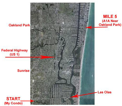
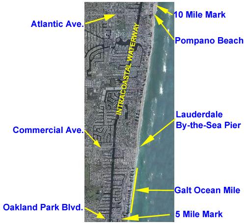
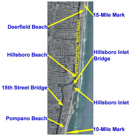
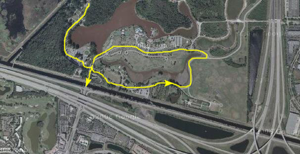
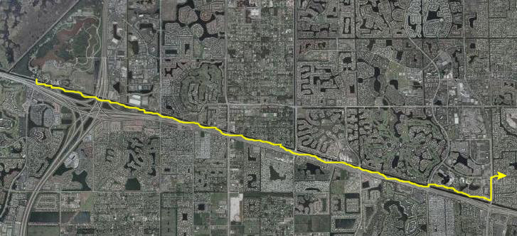
Earlier in this album you have probably come across a detailed description of this particular bike ride (as part of the description of the longest bike ride I have taken while down here last year), so I won't repeat all that narrative here. But I thought I might go ahead and show you the strip aerial views that cover this ride. The first two views below cover the first ten miles of this ride. The left-hand view shows the route from my condo over to the beach and then north to the five-mile mark. The right-hand view shows the next five miles which takes you into Pompano Beach.
 |
 |
 |
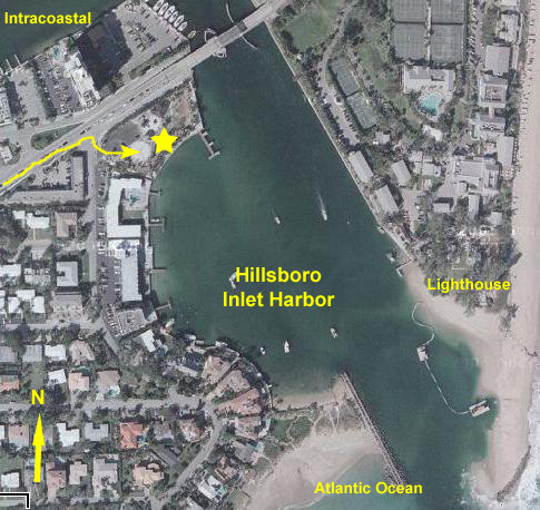 |
The ride to Hillsboro Inlet is one that I do frequently, and which Fred and I have done together quite a few times as well. It is a good distance for a 2 or 3-hour ride, and there is a nice little park to relax in once you get there.
Basically, I go east to the beach on Las Olas, and then up A1A along the beach, past Sunrise Blvd. and then through an area known as the Galt Ocean Mile. I am on A1A for part of that, and on less-traveled beach roads for the rest. This takes me to Lauderdale-by-the-Sea, which is the intersection of Commercial Avenue and the beach.
|
|
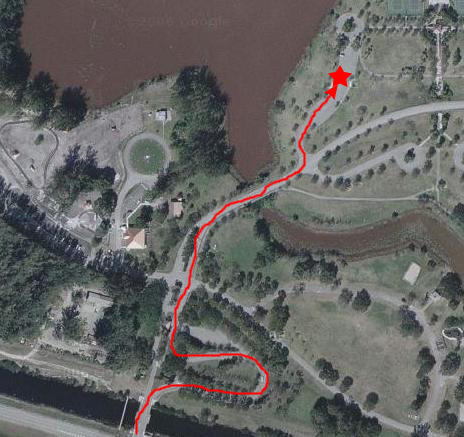
It was a wonderful afternoon, so I just stayed at the park that has recently been completed here and enjoyed the scenery. You might be interested in taking a look around the inlet and the park, so watch the movie of Hillsboro Inlet Park using the player at left.
A Trip to Markham Park
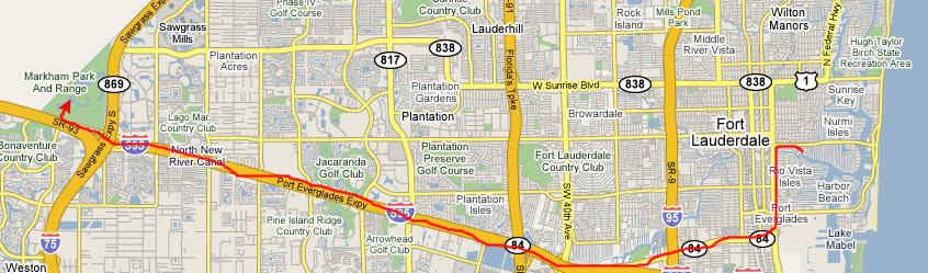
Getting to the park was pretty straightforward. It was out I-595, which is the same highway that connects to I-75 and goes across the state to Naples and the Florida West Coast. So I just went over to Federal, down to State Road 84, west to intersect with I-595 and then west to the Park. I overshot the correct exit, so I had to go a bit further than I needed to, but I found the park with little problem. The entrance fee was only a dollar, like it is at Hugh Taylor Birch over by the beach.
 |
|
|
That movie probably gave you a pretty good idea of what the land around the park is like. Of course, I expected it to be virtually flat, and it was, making it easy to bike ride around. (The only hills were artificial, as driveways went over lakes and ponds.) I got the bike off the carrier and headed off to see what was here.
The Markham Park Airdrome
 |
|
|
Although I could see and hear the planes, they were being flown from the airdrome way across the field, so I thought I would ride on over there and take a look.
 |
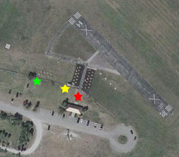
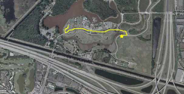
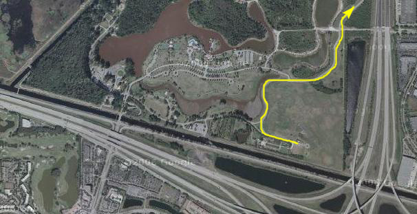
I'll use the aerial zoom view (above, right) to describe where the pictures were taken. When I first got to the airdrome, I parked my bike and stood behind the fence at about the location of the yellow star. Only flying club members could go out to the preparation area (the two black asphalt areas with the numerous preparation tables) or on out beyond that to the flight line where those controlling the aircraft stood. Most guys taxiied their planes from the end of the prep area out to the runway, but some of them carried the planes out there and then returned to the control line.
|
|
There was actually quite a lot of activity, with six or eight planes being readied for flight with four or five alreay in the air. It looked as if there were a maximum of four or five spaces on the control line, so I just assume that only that many planes could be flown at one time. Most of the planes were prop planes but I did see at least one jet (which looked and sounded and flew just like a jet plane). Use the player at right to watch a movie of the flight operations at the airdrome.
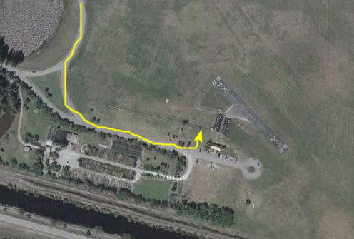
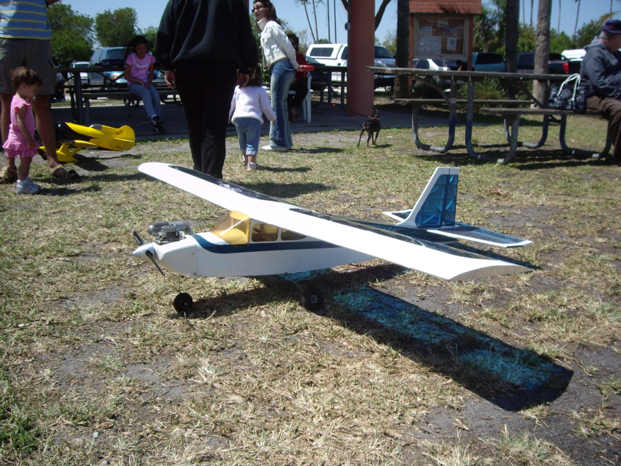
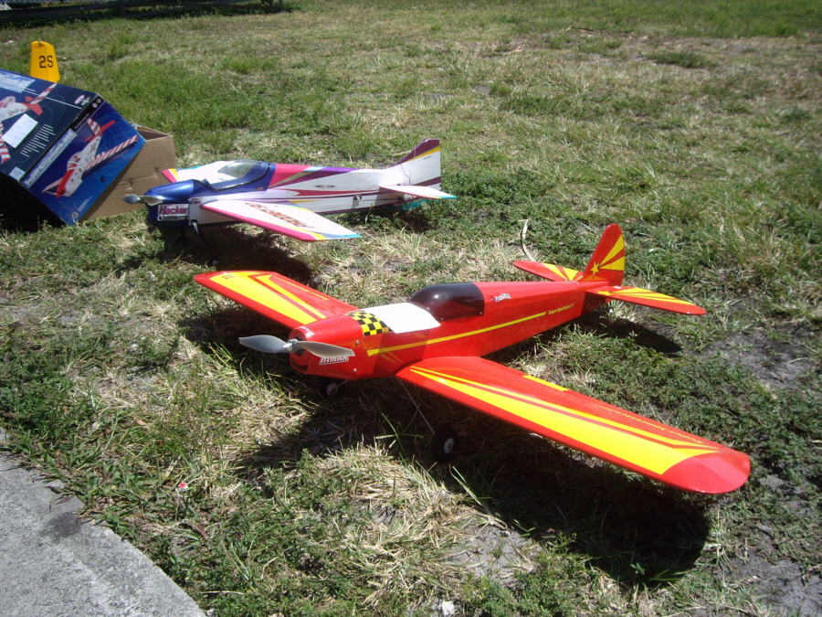
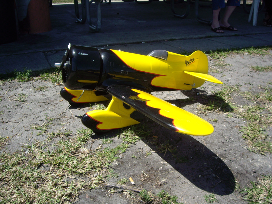
At the red star, there is just a paved walkway from the shelter building (bulletin boards, rest rooms and vending), and alongside the walkway folks had placed airplanes that they were wanting to sell. I took quite a few pictures of these planes, and I've placed thumbnails for three of the better ones below; to look at the full size image just click on its thumbnail:
 |
 |
 |
Finally, I moved down the fenceline to the green arrow; this was opposite the prep area for the helicopters. There was also a jet plane down here at the end of the control area; it flew a little later on. I took a couple of good pictures of the helicopters, and you can view those pictures here (with a jet as well) and here.
Riding the East Road
 |
 |
 |
 |
The Target Range
|
|
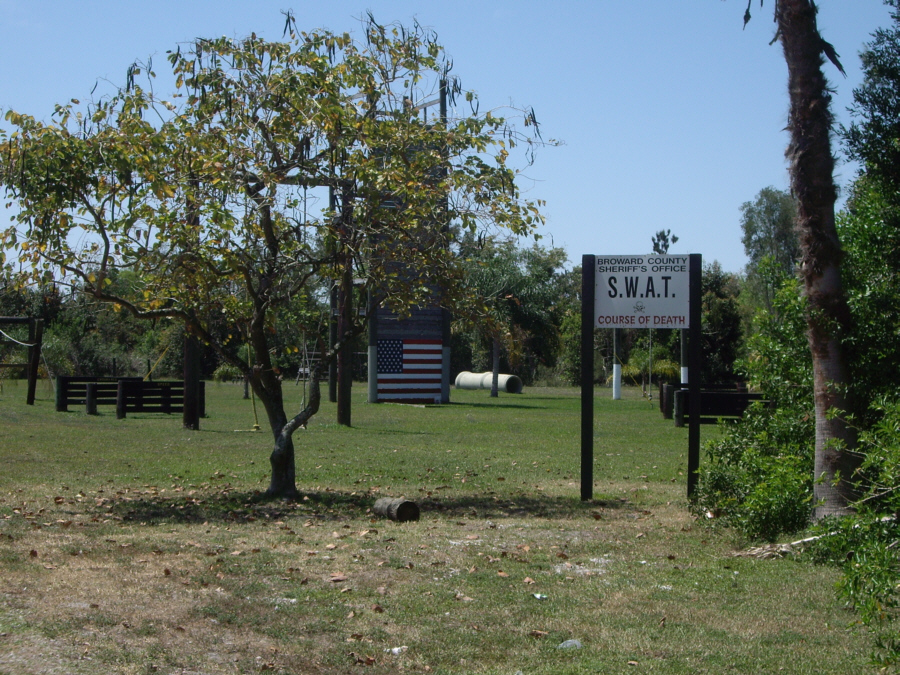
A ways past the skeet shooters, there were some people practicing with stationary targets, and they were interesting to watch, too. At the west end of the target shooting area I ran across something really interesting, something I'd never seen in a public park before (point #3 on the aerial view). Click on the sign below to see the full image:
 |
The West Campgrounds
Completing the Loop
 |
I made a big loop back around the end of the flying field, back through the center of the park, past the area where I'd parked, and then out the main entrance to the bike path.
The Bike Path along the New River Canal
 |
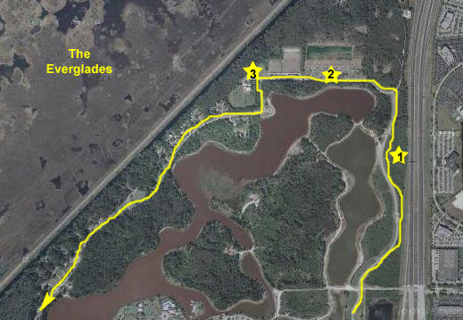
The bike path was really neat. It followed the New River Canal for about seven miles along I-595. You can see in the last aerial view of Markham Park above the canal that it parallels (on the south side). When it came to the Sawgrass Expressway (the major interchange on the aerial view immediately above), it went completely under it and all of the ramps connecting it to I-595. Then it continued, mile after mile. When it came to a major street, you had to wait for a light to cross and then continue on the other side; there was apparently not enough traffic on the path to warrant making underpasses or anything like that. But then there were clear crosswalks, and I made most of the lights without ever having to stop.
About a mile before University Road (Florida 817, if you want to refer to the map at the top of this web page), the path ended, so so I thought. What actually happens is that it shifts to the north side of the canal and continues towards town, passing some hotels and office parks. At University Road, the path does end, but there is a ramp leading from the bike path up the west side of University, past a convenient IHOP (where Fred and I might stop sometime) and then to a connection with the sidewalks and bike lanes along both University (north-south) and Peters Road (east-west). Peters Road connects up with Davie Boulevard, so it would be easy enough to bike all the way home, since Davie goes over I-95 and the New River, coming out near the Symphony Condominium and the Performing Arts Center.
The ride was a very pleasant one, and it was good to scope out the lay of the land for a time when Fred and I might take the bikes out to Markham Park. He's not big on city street riding, so I suppose we might park the car near the IHOP, have something to eat and then bike out to the park and back.
On the way back to the park, I came across three huge lizards crossing the path; they were much bigger than any I have ever seen in the wild here. Also on the way back, I saw a memorial that I'd missed going in the other direction. I assume there had been an accident along State Road 84.
My trip out to Markham Park had been very interesting and a great way to spend most of the day. I expect that Fred and I will return here sometime soon.
The Rest of My Florida Trip
But it was just a relaxing time until I headed back to Dallas on Thursday evening.
You can use the links below to continue to another photo album page.
|
April 24-26, 2007: A Visit with Ron and Prudence |
|
April 1, 2007: A Trip to the Arboretum with Tom and John |
|
Return to Index for 2007 |