|
October 3, 2009: Chicago, Illinois |
|
Return to the Index for Our Midwest Trip |
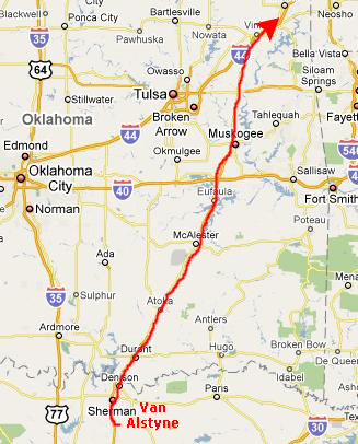
Our Drive to St. Louis Since we were heading north, I went up to Fred's house on Thursday around noontime, and we left from there. My car was washed and ready to go, so we loaded Fred's stuff, added ice to the cooler, and headed off.
|
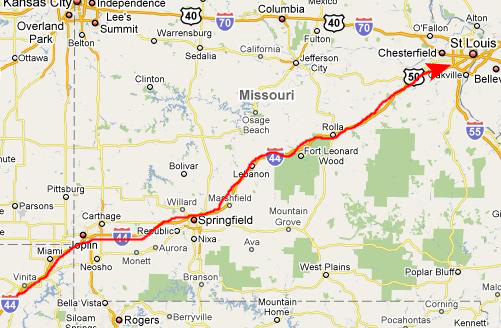
Interstate 44 heads northeast directly to St. Louis, passing first by Joplin, MO, and then by Springfield, MO (the capital of Missouri).
|
Tower Grove Park
|
|
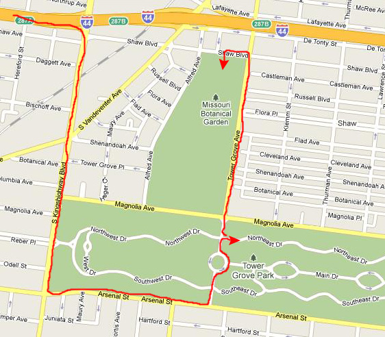
When we got to Arsenal Street, we found ourselves at the end of the wooded area we'd been passing, so we turned east on Arsenal and presently came to the entrance to Tower Grove Park. Again mistakenly, I thought that the Botanical Garden might be inside the park, so we drove into the middle of it with no sign of the Garden. So we stopped at what appeared to be an administration building (for Tower Grove Park, as it turned out) and we got directions to the actual entrance to the Botanical Garden.
But, before we just headed on to the Gardens, we spent some time wandering around near where we had parked the car, and we found was a very nice park with much to recommend it.
|
Tower Grove Park is a nearly rectangular tract 7,676 feet long and 1,550 feet wide. The area granted by Mr. Shaw’s deed was 276.76 acres, but the outer border, 200 feet wide, containing 74.74 acres, was reserved for leasing for villa residences, but this never materialized. Tower Grove Park is now a unit enclosed by four streets, and contains 289 acres. It is the second in size in St. Louis, and exceeds the next largest local park by more than 100 acres.
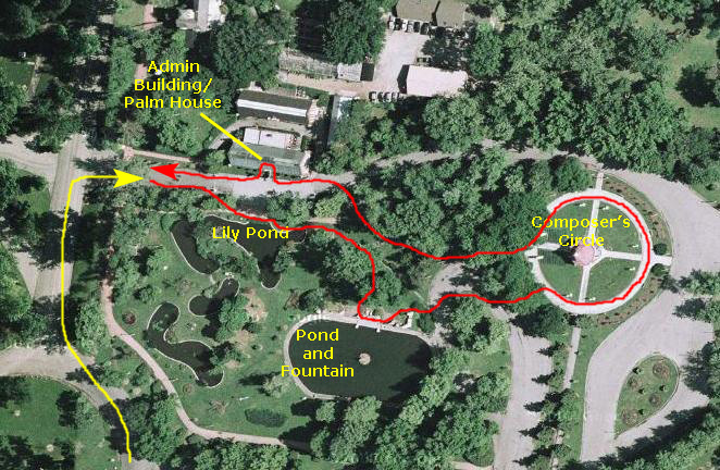
On the way into the park, Fred snapped a picture of what we later learned was the Turkish Pavilion. We parked near the Piper Palm House (more below) and went to walk around a bit. Just across the driveway from the Palm House was a lovely lily pond, and Fred asked me to take his picture using it as a background. Next, we walked a few feet southeast to the Fountain Pond.
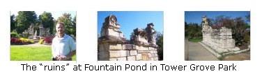
The fountain pond, which you can see in the aerial view left, above, is oblong in shape; on three sides, east, west and south, is bounded by grassy banks; on the north side, there is a rockery, and an artistic arrangement of stone blocks selected from the remains of the old Lindell Hotel. These large stones are laid together to resemble a ruined facade, including some broken columns, the whole having an irregular but graceful outline. There is a three‑tiered fountain in the centre of the pond.
|
Next, we walked along a tree‑lined walkway towards the music pavilion. This beautiful pavilion (bandshell) is surrounded by a circular walkway (as you can see in the aerial view above). Spaced around this walkway are marble busts of six famous musical composers: Mozart, Rossini, Beethoven, Wagner, Gounod and Verdi. We walked around the circle and then left the music pavilion heading back to the Palm House.
The Piper Palm House is the oldest standing greenhouse west of the Mississippi. It was established for the purpose of supplying the park with ornamental tropical plants, which are used in summer for decorative groupings on the lawns, and in the winter are tastefully arranged within the structure, forming a very interesting feature for the inspection of visitors. It is built of brick, with ornamental pilasters and stone caps; is situated near the north gate, and is oblong in shape, with the long sides to the north and south. The principal doorway faces to the south, and is ornamented with brick columns, a stone coping and metal flower vases, and at the east and west ends there are smaller doors and similar ornamentation. The roof is supported on iron girders and covered in slate and glass.
Although it was built in 1878 to house palms, the interior of the structure is acoustically "live" -- the perfect spot to listen to selections by Mozart, Verdi, Beethoven,. Rossini, Wagner & Gounod performed by eager musicians of the St. Louis Symphony Orchestra. You can see a picture of Fred inside the Piper Palm House here.
The Missouri Botanical Garden
Founded in 1859, the Missouri Botanical Garden is the nation's oldest botanical garden in continuous operation and a National Historic Landmark. The Garden is a center for botanical research and science education, as well as an oasis in the city of St. Louis. The Garden offers 79 acres of beautiful horticultural displays, including a 14-acre Japanese strolling garden, Henry Shaw's original 1850 estate home, and one of the world's largest collections of rare and endangered orchids. The year 2009 marked the Garden’s sesquicentennial anniversary. For over 150 years, the Garden has been an oasis in the city, a place of beauty and family fun— and also a center for education, science, and conservation.
History of the Missouri Botanical Garden
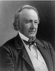 |
| Henry Shaw |
On his return to Sheffield, Henry began to assist his father with the business. Searching for new markets, the elder Shaw turned his sights on the vast markets of the Americas. In 1818, Henry accompanied his father on his first trip across the Atlantic Ocean where the pair did business in Quebec, Canada. Young Henry must have impressed his father with his business acumen, because the next year he was sent to New Orleans alone to locate a misplaced shipment of goods. Henry recovered them, but could not find a buyer in New Orleans. With the business acumen and entrepreneurial spirit that was to mark his adult life, Shaw was determined to find a market for the goods in the interior of the country.
In the Spring of 1819, Henry Shaw purchased passage for himself and his goods on a steamship called the Maid of Orleans. The trip, which took 40 days, cost Shaw $120. On May 3, 1819, Shaw landed in a small French village on the Mississippi called St. Louis. Shaw set up a hardware store in St. Louis, selling high quality cutlery and other metal products. His first store was an immediate success. During the two decades he stayed in this business, roughly 1819 to 1839, St. Louis grew quite rapidly- largely due to the influx of pioneers moving westward
Shaw never married and did not live extravagantly. The income from his business, therefore, soon provided him with a surplus of funds. He invested the income from his hardware business shrewdly, buying a great deal of real estate in the St. Louis area. Shaw bought many commercial properties and other lots in the city. He also bought large tracts of land in the outlying areas. One of properties consisted of a 1,800-acre tract in an area previously known as the Prairie de Noyes Commons. After 1839, Shaw sold his hardware business and retired from an active life in business. A fellow St. Louis businessman who knew Shaw personally later recounted that Shaw retired the year he earned $22,000 (almost $500,000 in today's dollars). Of the amount Shaw said "this was more money than any man in my circumstances ought to make in a single year." When he retired, his fortune totaled some $250,000 (over $5 million today).
After his retirement, Shaw took advantage of his newly found free time to make the Grand Tour of Europe, and he made several more extended trips to Europe in the next decade. In 1851, Shaw made his final trip abroad in order to attend the first World’s Fair in London. On this trip, he visited the Royal Botanic Gardens at Kew and the Crystal Palace Exhibition. He also saw the wonderful gardens at Chatsworth, the Duke of Devonshire's country seat in Derbyshire. These gardens were two of the finest gardens in the world, and they inspired Shaw. It was apparently during his walk through Chatsworth Gardens that Shaw conceived of the idea of creating his own garden on his properties in St. Louis. For the rest of the life, the creation and care of a garden and a park on his property would be his principal occupation.
|
Upon his return from England in 1851, Shaw began planning his garden and planting trees on his erstwhile treeless estate. During his lifetime, he planted thousands of trees and shrubs on the eighty-acre tract around this country home. Henry Shaw was determined to have not just a pleasure garden but also rather one of the finest botanical gardens in the world. Historically, botanical gardens served the same role in the collection and study of plants that zoos played in the collection and study of animals. In his quest to do so, he eventually contacted Harvard University’s Asa Gray, then America’s leading naturalist.
Gray and other advisors helped Henry Shaw make the Missouri Botanical Garden a first-rate scientific institution. In a letter dated August 10, 1857, Sir William Jackson Hooker, the Director of the Royal Botanic Gardens at Kew advised Shaw of the importance of having a library and museum attached to the Garden. Shaw quickly empowered Dr. George Engelmann to purchase for him in Europe many books that would become the heart of the Garden’s research collections. Engelmann was also able to purchase the herbarium of the recently deceased German botanist Johann Jakob Bernhardi. He bought the 60,000 specimen herbarium for $600. Today the Missouri Botanical Garden herbarium contains over five million specimens, and the library contains over 120,000 bound volumes.
When Henry Shaw needed a building to house his library and herbarium, he commissioned George I. Barnett to design it. Shaw asked Barnett to base the design on a building at Kew Gardens. The red brick building that Barnett designed also housed Shaw’s museum of natural history, and came to be called the Museum Building. Inside, the ceiling was painted with a mural of natural science and the names of famous scientists.
From the beginning, Shaw not only wanted the garden for himself, but also for the people of St. Louis. In 1859, he opened the doors of his garden to the public. It was to be open six days a week and also for two Sundays every summer, so that working people could see it as well. For the next thirty years, until his death in 1889, Shaw personally oversaw the development of the garden buildings and grounds. He hired the best horticultural personnel to care for the grounds and accomplished scientists such as William Trelease to do scientific research at the Botanical Garden. At the extreme North end was the fruticetum, a place for the growing of shrubby plants. To the south of this area were two greenhouses. In 1868, Shaw built the Main Conservatory, also called the 1868 Greenhouse. This greenhouse housed exotic plants. In the 1880s, Shaw added a smaller brick greenhouse to the north of the Main Conservatory. This structure, known as the Linnean House, designed by Shaw’s favorite architect George I. Barnett, housed palms, citrus and other tender plants. The Main Conservatory was eventually torn down in 1916, but the Linnean House is still standing. Today the Linnean House is the oldest continuously operating greenhouse west of the Mississippi and today it houses the MBG collection of camellias.
In the late 1880s Shaw’s health began to deteriorate. In 1889, he suffered an attack of malaria, and it was too much for his already weakened system. In August, Shaw began a steady decline and he died at 3:25 Sunday morning, August 25th, 1889. His physician and some friends attended him in his final hours. His death scene was described next day by several local newspapers, in which it was the lead headline. After his death, Shaw’s body lay in state in the museum building for viewing by the public. The crowds that came to pay their last respects were enormous, and they saw him lying in state in the museum building surrounded by flowers and exotic plants.
Henry Shaw had made careful arrangements for the governance of his Garden after his death. Shaw wanted his Garden to be run as a first class botanical garden in order to provide knowledge and enjoyment to the people of St. Louis and the world for all time. Therefore, he was wary about turning over the ownership and control of the Garden to a single person, the city or even the state. So, in 1859, Shaw made a will that would create the Missouri Botanical Garden as a charitable trust upon his death. That is, he left the bulk of his property in this will to a Board of Trustees to be held in trust for certain purposes, specifically for the purpose of operating a Botanical Garden.
In Shaw’s will, he summarized his wishes for the garden:
| "Whereas I have for many years been engaged in laying out and establishing a Botanical Garden, with a museum and library connected therewith upon a portion of the tract first described, and which is now known as the Missouri Botanical Garden, with the design at the time of my death to convey the same with other property to Trustees for the object and with the view of having for the use of the public a Botanical garden easily accessible, which should be forever kept up and maintained for the cultivation and propagation of plants, flowers, fruit and forest trees, and other productions of the vegetable kingdom; and a museum and library connected therewith, and devoted to the same and to the science of Botany, Horticulture, and allied objects." |
Our Tour of the Missouri Botanical Garden
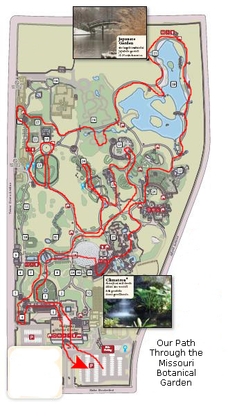 |
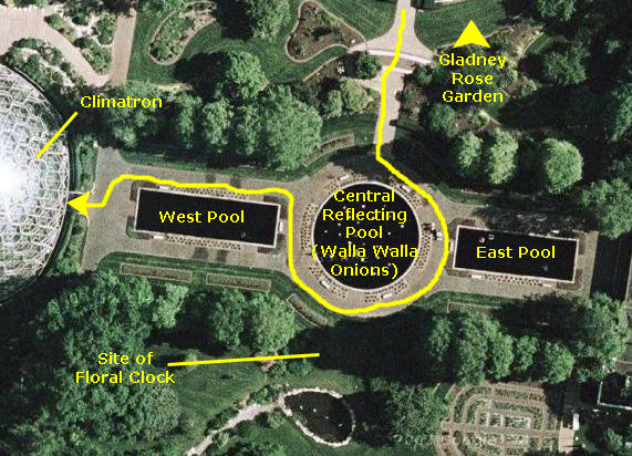
The web site for the Missouri Botanical Gardens was the source of the map at left, although the version on the web site is larger and keyed to a list of buildings and gardens. What I could do is use full-size sections of that map (which was in the guidebook that we carried around) to show you our tour in sections. But what I think I will do instead is to use aerial views of the gardens- taken, of course, from Google Maps. There are certain features that just don't show up well on the printed map- the Climatron, for instance. The Climatron is almost as impressive from the air as it was when we toured it.
The only problem will be that the aerial views are all oriented with north to the top, while the guidebook map is the opposite. So it is best to use one or the other but not both, and I think that the aerial views will add more to your enjoyment of our tour than would the guidebook map. (You should, incidentally, visit the web site for the Missouri Botanical Gardens; there is a wealth of historical, pictorial and descriptive information about the gardens that I have simply not been able to include here.
So that's how we'll do the tour- section by section- with all the pictures of a given location grouped together, regardless of how many times we passed through it. Generally, though, you'll be able to walk along with us on our tour, seeing what we saw in the order that we saw it. So put on your walking shoes and let's begin!
The Ridgway Visitor Center
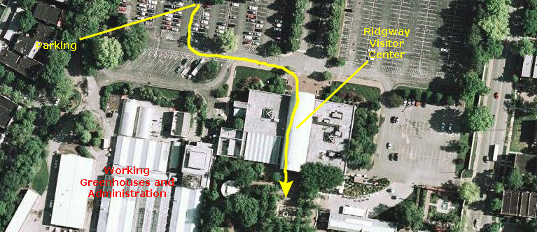 |
The Ridgway Visitor Center was designed by a St. Louis-based firm, and it replaced an older garden entrance. The building is recognizable by its large, barrel-vaulted ceiling, inspired by the Crystal Palace of the 1851 Great Exhibition in London, which Garden founder Henry Shaw visited. Missouri Botanical Garden Blue Chandelier - 2006, by renowned glass artist Dale Chihuly, hangs from the atrium, visible through the front window. The installation weighs 2,300 pounds and measures six feet across by over 20 feet high. It consists of 928 individual blue and clear glass spirals and gooseneck shapes; have a closeup look at them here.
We purchased our admission to the Garden at the ticket windows on the lower level; as it turned out, our Dallas Arboretum Membership got us free entry. (Thank you, Steve!)
Inside the lower level is the 386-seat Shoenberg Theater, which hosts events, lectures and concerts throughout the year, and the Garden Gate Shop. Trunk shows and rotating exhibits can be found in Grigg Lobby. The Orthwein Floral Display Hall is the site of the annual Orchid Show. The Jordan Education Wing includes the Beaumont, Missouri, Botanical, and Garden rooms for classes and meetings. An orchid display blooms in the Beaumont Room all year.
Then we climbed the stairs to the upper level to access the Garden grounds. On the way up the stairs, we got another beautiful view of the Chiluly installation. On the upper level there are rotating art and photography exhibits. An old-fashioned cart features Plants in Bloom, a sampling of fresh blossoms cut from plants throughout the Garden. Each is mapped and labeled to give visitors a preview of what they’ll see before they step outside. The upper level also houses Sassafras, the Garden’s café, that has seating both inside and also outside on the verandah where we had lunch at the end of our tour.
Finally, we walked outside to begin our garden tour, pausing at a beautiful rectangular fountain.
The Linnean House and Gladney Rose Garden
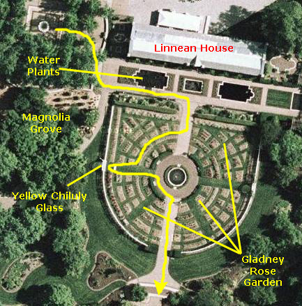 |
After World War I, the house was renovated: the roof was converted to all glass, and many loads of soil were brought in to create indoor landscape beds. Rare conifers, rhododendrons, azaleas and heaths were planted, along with a handful of camellias. The central water feature was added, created out of native limestone and fashioned to look like a natural spring along the Meramec River. A severe hailstorm in 1927 caused major damage to the all-glass roof, and it was decided to make the roof 1/3 slate and 2/3 glass (as it is today).
The house was converted largely to camellias in the late 1930's; the largest of the trees in the house today most likely date to this time. The majority of the camellias, however, were planted in the early 1960's and 70's.
Below are some thumbnails for a few additional pictures of the Linnean House; click on them to view the full-size images:
|
Outside the Linnean House there were three pools containing water plants- two large pools flanking a smaller, central pool. One of the pools also featured a sculpture of a woman.
|
|
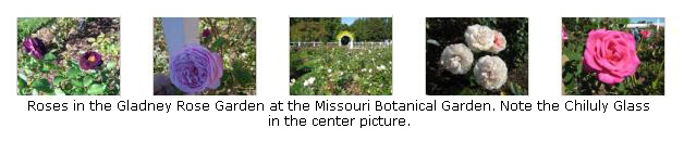
Next, we turned south into the Gladney Rose Garden, which was established in 1917. Shaped like a giant wheel, this garden is surrounded by a formal, old-fashioned fence, and is accented with small arbors and many varieties of climbing roses. There is a beautiful fountain in the center of the garden, as you can see in this view looking back towards the Linnean House. Below are some thumbnails for various pictures we took of the roses in the garden. You can see a full-size image by clicking on its thumbnail:
|
In one of the pictures above, you can see that there are two gates in the white fence that surrounds the Gladney Garden. We walked over to the western gate to get a look at the yellow Chiluly glass that adorned the top of it. The glass, echoing the shapes in the "Blue Chandelier" installation in the Visitor Center, was in a beautiful bright yellow, and you can look at it close up here.
The Central Reflecting Pools and Floral Clock
 |
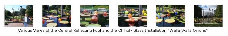
In the center, circular pool there are three tall pedestals with small sculpted figures of Greek and Roman gods and goddesses atop them. The pool also contains some of those large lily pads with the turned-up edges.
And, most interesting of all, floating in the pool are a number of Chihuly sculptures, collectively entitled "Walla Walla Onions." These glass bulbs were originally installed in Seattle, Washington, and reflected the actual onions grown around Walla Walla, WA, where Chihuly spent a great deal of time. They have been a popular piece of his, and the Gardens have commissioned and acquired their own collection of them.
We took quite a few pictures of the central pool and the Chihuly glass; thumbnails for six of these are below. Click on them to view the full-size images:
|
Just southwest of the central pool is a large floral clock. The first-ever floral clock in the Gardens, it was created for the 150th anniversary of the Botanical Gardens, and it honors the Gardens' Victorian and St. Louis roots. It measures 20 feet across and features a working cuckoo chirping every quarter hour. It is powered by solar offsets from panels installed in the Kemper Center for Home Gardening.
Plant material on the clock is changed out seasonally over the course of the temporary display. The summer design features a traditional celestial theme with moon (white, dark purple) and sun (chartreuse-yellow), made of Hemigraphis, Begonias, Alternanthera and Dichondra. Alternanthera has also been used in the clock’s Roman numerals, and dichondra in the moving clock hands. (The Spring plantings feature cool-season, low-growing crops, such as pansies (Viola), ornamental kale (Brassica), and alyssum (Lobularia).
In keeping with floral clock tradition, the numerals on the bottom half of the clock are upside down and the Roman numeral 4 is represented IIII, balancing the VIII opposite. The world’s oldest floral clock was established in 1903 in Edinburgh, Scotland. (At the 1904 World’s Fair, St. Louis displayed the world’s largest floral clock in Forest Park.)
The western rectangular pool features a sculpture of two women as well as more lily pads. Following this western reflecting pool towards the west leads you to the Climatron.
The Climatron, Schoenberg Temperate House and Exhibit Hall
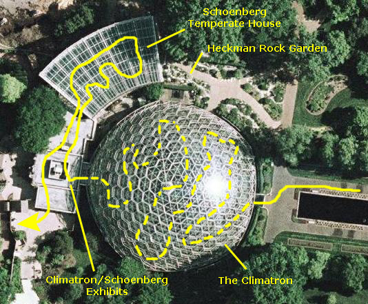 |
The Climatron, named for its climate-control technology, stands 70 feet high and 175 feet in diameter. It encompasses a volume of 1.3 million cubic feet, and a ground surface of about 24,000 square feet (more than half an acre). The form of the building was chosen to fit the specific demands of a greenhouse. The Climatron has no interior support and no columns from floor to ceiling, allowing more light and space for plants. Instead, the weight of the dome is carried to the ground on five piers around the perimeter of the circle. The interlocking triangle design helps to distribute weight throughout the dome, allowing it to be lightweight but strong.
The original outer structure was made of lightweight aluminum, lined by a plastic Plexiglas "skin" suspended below the aluminum framework. Unfortunately, the Plexiglas discolored and leaked, so in 1988 the greenhouse was closed and a new aluminum and glass geodesic dome was built in its place. Each of the 2,425 panes that make up the new glass dome is made of a plastic interlayer sandwiched between heat-strengthened glass. The panes are also coated with low-e film, or low-emissivity, which helps conserve energy by retaining the solar heat collected during the day for use at night.
With the new dome in place, the old aluminum structure was no longer necessary. It was retained, however, for its historical value. Today the Climatron is actually a dome within a dome, the new dome standing just within the original aluminum framework. During the renovation, new heating, cooling, and ventilating systems were installed. Paths were made accessible to the disabled, and the adjacent Shoenberg Temperate House was added.
During the 22 month-long renovation, the interior of the Climatron also underwent extensive landscaping changes. Major features were added, including two large waterfalls, rock and cliff landscaping, and tropical theme areas. The original clay-based soil was removed and an improved mixture ideal for tropical horticulture was put in its place. It took six hours with a bulldozer just to mix the batch of new soil. Only a few of the most important plants remained in the building during the renovation. The rest were transplanted either to holding facilities or to other botanical gardens. Replanting was finished, and a dramatically changed Climatron was re-opened in 1990.
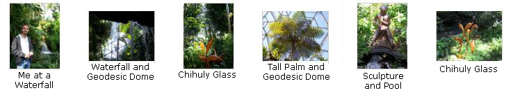
Below are thumbnails for some of the pictures we took as we wandered through the inside of the Climatron. You can click on them to view the full-size images:
|
The Climatron simulates a tropical lowland rainforest. In the Climatron there are about 1,200 species of the total estimated 160,000 species of tropical plants. It is an introduction to tropical plants and gives a good glimpse of a warm moist forest. No building can begin to house all of the diverse plant forms found in the tropics, but the Climatron illustrates the structure of the rainforest and many of its special characteristics. About half of the plants in the Climatron were collected in the field, which gives them more scientific value than plants raised in a greenhouse. The Climatron is also home to representatives of numerous endangered species.
|
|
The main entrance to the Schoenberg Temperate House is through the Heckman Rock Garden, but we came in through the connecting corridor from the Climatron. The Shoenberg Temperate House was built in 1990 and features plants from five regions of the world that share a Mediterranean climate: warm, dry summers and cool, rainy winters. It also features plants of the southeastern United States, and plants from China and Japan.
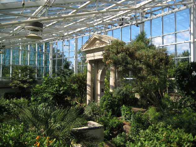 |
| View from the Upper Level Inside the Schoenberg Temperate House |
Continuing past the bog we passed through a gate and entered the colorful Moorish Garden, modeled to resemble the 11th century garden at the Alahambra in Granada, Spain. Beautiful blue and white tiles adorned a central fountain, surrounded by colorful flowers. There were large fig trees here, and during the summer they produce a surprising number of figs which are served as a part of various dishes in the cafe. There were also some benches, so we took the opportunity to sit down and enjoy the cool sound of splashing water in the fountain.
Just beyond the Moorish Garden is the Biblical garden. This garden features approximately 30 to 40 of the 110 plants that are mentioned in the Bible. The Pomegranate tree (Punica granatum) features beautiful orange blossoms in late May and showy red fruits in fall. Sprouts were growing from the stump of a date palm (Phoenix dactylifera) which grew too big for the Temperate House and had to be removed. There were capers, grapes and many other Biblical plants, and these change during the seasons.
Next, we ascended to the upper level via the stairs along the California wildflower slope; this section features California poppies which are a riot of color in the spring. Walking around back to the southwest past the Cork Tree (Quercus suber) and the southwest plantings along the upper level we came to the large stone portico that we had been seeing from all around the lower level. Designed by the firm of Barnett, Haynes and Barnett, the portico was the main entrance to St. Leo's School in south St. Louis, built in 1902. It was salvaged from the school's demolition in 1978.
Other trees that we saw upstairs included an Olive tree, Carob (a chocolate substitute), and Bay laurel, the leaves of which flavor spaghetti sauce. We saw many flowers from the mediterranean climate regions of the world, such as African daisies (Osteospermum fruticosum), Australian kangaroo paw (Anigozanthos flavidus 'Pink Joey') and Mediterranean throatwort (Trachelium caeruleum).
At the base of the portico, we stood on the "balcony" and enjoyed a bird's eye view of the walled Moorish Garden.
|
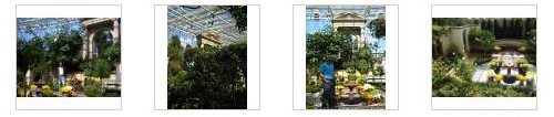
Before we leave the Temperate House, I want to include a few other pictures that we took of the portico from the lower level and of the Moorish garden from the balcony. I have put thumbnails for these pictures at left. Click on the thumbnails to view and from the balcony. I have put thumbnails for some of these pictures at left. Click on the thumbnails to view the full-size images.
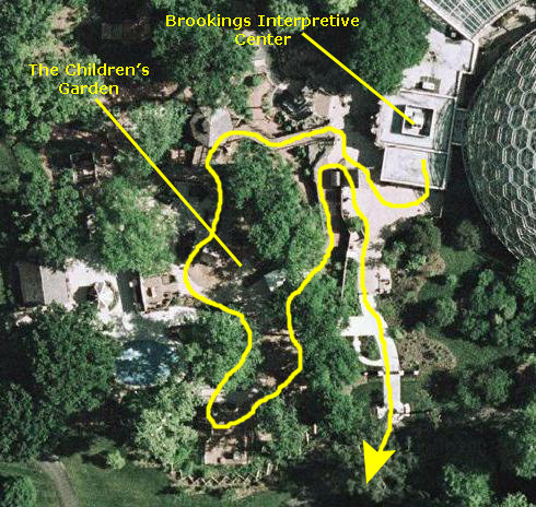
Finally, we walked down the staircase on the other side of the portico to find ourselves back in the bog. From here, we walked back into the Brookings Center Interpretive Center to look around.
As it turned out, the Center was mostly exhibits on "Going Green," and showcased renewable construction materials, high-efficiency appliances and other "green" topics. I got the feeling that the Center was designed more for kids than adults, but there was plenty to look at.
|
|
The Children's Garden
 |
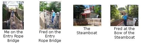
|
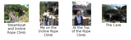
|
|
|
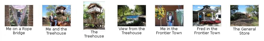
|
|
|
The Home Gardening Center
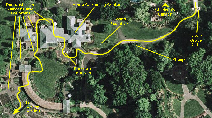 |
The walkway turned west through a shady area; off to the side were, inexplicably, a group of sheep sculptures. The walkway continued around the short distance to the Home Gardening Center. Outside on the lawn Fred found some very interesting wind‑powered sculptures that were slowly turning. They were similar to some Fred had seen in Santa Fe a while back; I am sure he would like to have one at his own house.
We walked down a level to the entrance plaza for the gardening center. In the plaza was a fountain with raccoon sculptures, similar to the animal sculptures that adorn the back garden of the Dallas Arboretum. In front of the Center is a manicured lawn that is bounded by plantings on the east and a curved arbor on the south and west.
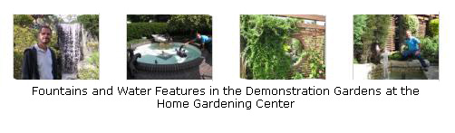
We walked through the Center looking at some of the exhibits, and then went out the back, through some small demonstration patios and then around the west side of the Center. This entire area seems to be a series of small patios or patio gardens, done in different styles and with different plants, presumably to give the home gardener some ideas of what to do with relatively small spaces. There were quite a few water features incorporated into these small gardens, and so we took some pictures of them. I've put thumbnails for some of these pictures below; you can click on them to view the full-size images:
|
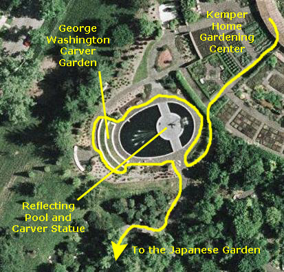
From the demonstration gardens we walked a short distance out underneath the arc‑shaped arbor until we found a pathway over to the Carver Garden.
The George Washington Carver Memorial Garden
 |
Carver was born into slavery in 1865, in Diamond Grove, Missouri, a few miles southeast of Joplin. His interest in nature and plants developed early and by the age of 12 he was known in the local farming community as “the plant doctor.” By the end of his life, Carver was an internationally renowned figure, one of America’s greatest scientists, teachers, humanitarians, and advocates for productive, sustainable agriculture. At the Tuskegee Institute in Alabama, he revolutionized farming in the South by introducing plant diversity, crop rotation, natural fertilizers and conservation methods. Witnessing the destructive effects of centuries of cotton farming on the South’s natural resources, Carver found crops that would restore depleted soils – notably peanuts, sweet potatoes, soybeans and black-eyed peas – and developed hundreds of by-products and uses for them that would increase their market value for Southern farmers.
The one-and-a-half acre Carver Garden is located on western edge of the botanical garden, between the Seiwa-en Japanese Garden and the Kemper Center for Home Gardening. Entering from the south, as we did, we walked down a path lined with inspirational inscriptions from Carver’s writings and speeches, emerging at the central reflecting pool. Most of the flowers were gone for the season now, and the fountain was turned down, but it was still a nice place to visit. I walked around to the far side to get a picture of Fred, a life-size bronze of Carver and the pool. You can have a look at that picture here. When we were done here, we went back out of the small garden by the south entrance and continued along a pathway to the south and the Japanese Garden.
The Seiwa-en Japanese Garden
Rather than the typical garden filled with striking statuary, showy plants and flowers, the Japanese Garden is a monochromatic understatement, in which the viewer is permitted the thrill of personal interpretation and discovery. Such gardens, with a lake as their main feature, were popular among the Japanese feudal lords or daimyo of the 17th and 18th centuries. Because of the extensive lawn areas, they possess a feeling of openness unique to this style.
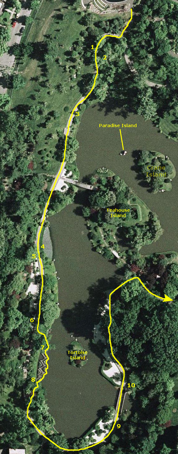 |
The lake has four islands. Tortoise Island and Crane Island, both symbols of longevity in Japanese lore, are inaccessible to the public. No bridges reach them. On Crane Island, trees planted to extend over the water represent the wings of cranes in flight. The head of the tortoise on Tortoise Island is the tilted stone at the north end of the island, the tail is at the opposite end, and the legs are stones on both sides. Two additional stones in the water at the head of Tortoise Island suggest other tortoises swimming.
Paradise Island is formed by three large boulders, and you can see it in a picture of Fred beside the lake (3). It is the symbolic spiritual center of the garden, representing eternal happiness and immortality. Stone are important features, almost always used in groupings of uneven numbers, typically three or five. Stone are used to symbolize the five universal elements of earth, water, fire, wind, and sky. Paradise Island is also called Horaisan or Horaijima in Japanese mythology.
Nakajima, Teahouse Island, is the innermost island. It is connected to the mainland by two footbridges, bridges being one of the traditional elements of a Japanese garden. They are intended not solely as a means of crossing from island to shore, but to provide points where garden visitors can enjoy viewing the water, the reflections of sunlight on foliage, and the fish swimming below.
Drum Bridge, or Taikobashi, connects Teahouse Island with the northwest mainland. You can see it in picture #3, and also in this picture of me beside the lake (4) taken from the walkway just south of the bridge. Its name alludes to its rounded shape, which completes a circle in its own reflection in the water. It is constructed of redwood and is left unpainted to preserve its natural appearance. The other bridge, Earthen Bridge or Dobashi, connects the island to the south shore.
Great care was taken with Seiwa-en to ensure that the Garden would be traditionally authentic, incorporating in its design many concepts that make a garden more than greenery. We could see distinct aspects of its beauty when we viewed it from different vantage points. It was a world in microcosm, featuring carefully designed replicas of natural waterfalls, beaches and islands, sometimes with minimal plantings, as in the raked dry gravel Zen garden (5).
The Japanese Garden has evolved from centuries of tradition and a multiplicity of cultural influences synthesized as a uniquely Japanese art form. From Shinto, Japan’s first major religion, came the worship of trees, rocks and streams. From Zen Buddhism came the concept of the garden as a symbolic version of nature, and an austerity and simplicity that characterize much of Japanese art even today. This austerity can be seen in the plantings along the walkway south of the Zen garden (6). From both came a reverence for nature.
Also part of the southwest lakeshore is a unique zig-zag bridge called Yatsuhashi, a name meaning “eight bridges” and referring to a place in Mikiwa Province, Japan, where in the 10th century a single river branched into eight channels. Each channel was crossed by a bridge around which grew masses of irises. You can see two pictures that we took of this bridge here (7) and here (8).
The lake is the principal design element in any chisen kaiyushiki, or “wet-stroll” garden. The chisen garden is the most orthodox and popular style among all Japanese garden designs. The lake is of irregular shape, in line with the Oriental practice of designing ponds in shapes corresponding with the Chinese character for “mind,” the character for the number nine, or the character for "gourd."
On the large aerial view at left, I have indicated our path through this garden which, in effect, was a path completely around the lake. We began by going down the western walkway after leaving the Carver Garden, bypassing the bridge to Teahouse Island, and continuing around the south end of the lake. As we started back north from the south end of the lake (9), we could look across and see the zig-zag bridge. A bit further on there was another bridge across a small inlet; I let Fred go on ahead so I could photograph him photographing the ducks (10). When arrived at Earthen Bridge over to Teahouse Island, we turned instead to the east and the walkway leading to and through the English Woodland Garden.
Although only one of them appears in any of our photographs, the Japanese garden contains many traditional stone lanterns. the one that does appear is the Rankei lantern, a unique 19th-century-style lantern that is placed at the southwestern corner of Teahouse island so that its image is reflected in the water.
The English Woodland Garden and Boxwood Garden
 |
Like its English counterparts, the garden here has three vegetation layers. First is an upper canopy provided by trees such as oaks, maples, ashes and tulip trees. Some of the most impressive specimens include Pumpkin Ash, Swamp White Oak and Pin Oak. The middle layer contains the azaleas, rhododendron and hydrangea. The lower layer is filled with herbaceous perennial plants and ground covers, such as hostas, perennials and wildflowers.
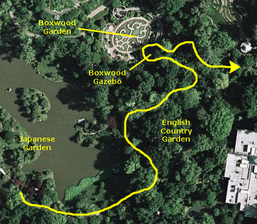
A key attraction of the English Woodland Garden is the meandering brook that flows from a pool in the northeast corner, under several limestone bridges, and into the Japanese Garden lake by way of a waterfall. We tracked the stream on a winding path of stepping stones, and marveled at the hundreds of limestone boulders carefully placed to provide naturalistic concealment of what is actually a 220-foot concrete liner. A second water feature is bog display of plants that thrive in wet soils or aquatic habitats. The garden features a bronze sculpture of the Three Graces by Gerhard Marcks (1889-1981).
One of the meandering pathways leads to a gazebo that overlooks the Blanke Boxwood Garden. Usually, this garden is entered from the north through a walled brick courtyard that you can see behind me in this picture Fred took of me at the Boxwood Garden. The actual Boxwood Garden is a formal, oval boxwood parterre accented with colorful flowers and ground cover. The low hedges of boxwood are shaped to form the initials of Henry Shaw, the Garden’s founder. This very elegant walled parterre displays an outstanding collection of boxwoods, which are notoriously difficult to grow in the Midwest. In contrast to the garden's formality are "leaping waters" fountains that jump into the air and arch over the paths.
|
|
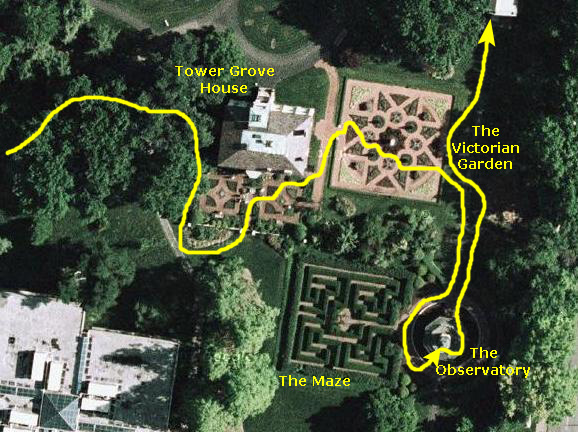
The "Lichtenstein Victorian District":
Tower Grove House
The Victorian Garden
The Maze
The Observatory
When we were done at the gazebo, we walked back along the stream through the English Country Garden, found the main walkway, and continued east. From a distance, we could see Tower Grove House through the trees. As we came close to the house, we passed by the sculpture "The Fountain Angel," which was done in 1902, by Italian Raffaello Romanelli for the 1904 World’s Fair. This bronze statue was restored in 1975 and moved to the Garden in 1976. The angel’s slightly smaller-than-human scale stands in a small basin within a plaza of white marble chips, with water flowing from urns in her hands.
 |
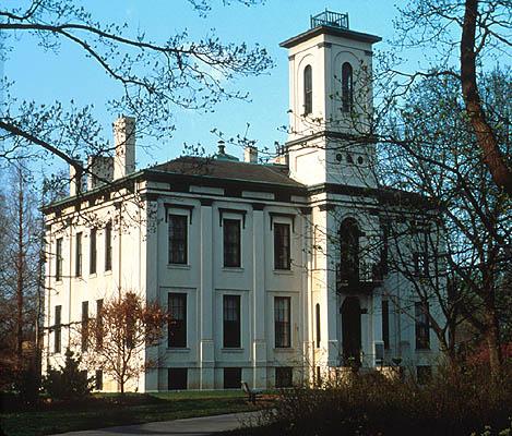
Tower Grove House
Tower Grove House, Henry Shaw's 1849 Victorian country home, was named for its significant tower overlooking a grove of oak and sassafras trees. The house was renovated in 1953 and furniture and materials once belonging to Shaw were located and returned. Tower Grove House was rededicated on October 29, 2005 after another extensive renovation. The house has been restored to reflect Shaw's original country home as he lived in it.
After his retirement, and after his first trip to Europe, Shaw decided to make St. Louis his permanent home and became a U.S citizen in 1843. In 1849, he commissioned George I. Barnett, an English-born architect and friend, to design Tower Grove House. It has an Italianate influence, a style popular among Americans who traveled to Europe in the Victorian era. The name Tower Grove House was inspired by the house’s significant tower.
We saw the house from two different perspectives. First, as we came around through the herb garden and past the sculpture "Child Sundial," we got a rear view of the mansion. A little later on in the afternoon, when we were exploring the garden in front of the house, we came up the main walkway from the north to find a great view of front of Tower Grove House.
|
The Victorian Garden
The Kresko Family Victorian Garden, east of Tower Grove House, resembles an early garden built by Mr. Shaw in front of his original conservatories, on the present site of the Climatron reflecting pools.
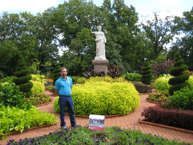
Then, as now, the centerpiece is the white marble statue "Juno" by Carl Nicoli, which was acquired by Mr. Shaw in 1885.
This garden is an outstanding example of the height of fashion in England at the time Mr. Shaw was planting his gardens in St. Louis. The style of landscaping was introduced in the early 1800s, when new varieties of flowers were being developed and new species were coming into England from different parts of the world. Elaborate and colorful combinations of flowers, foliage and succulents are combined in “plant tapestries,” the combinations referred to as “carpet bedding.”
Here is a picture of Fred in the Victorian Garden.
|
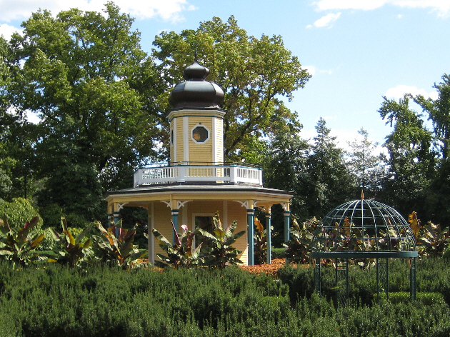
The Observatory and Maze
The Piper Observatory is a replica of one built by Henry Shaw in the 19th century in Tower Grove Park. The one in Tower Grove Park was designed for observation of the heavens, as its name implies. The replica here in the Missouri Botanical Garden could serve that purpose, but it is mostly used, as such towers were in Victorian times, to watch people going through a garden or maze below.
Many Victorian gardens had buildings and plantings that were fanciful, romantic and mysterious. The maze, revived as a garden element at the beginning of the 19th Century, exemplifies these qualities. The Kaeser Memorial Maze, created in 1986, re-creates a labyrinth constructed by Mr. Shaw in the 1800s with sunken hedges of yew and a gazebo at its center. It was thought that Shaw's original maze was inspired by one he had seen at Hampton Court. This maze has been replanted recently, so it will, apparently, take some time before people in the maze can't see over the yew hedges.
|
|
The Mausoleum Area
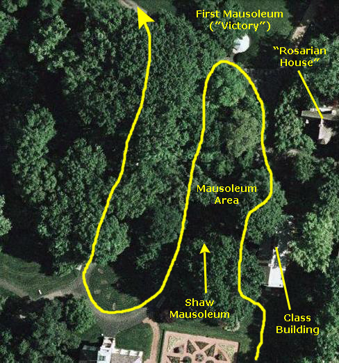 |
In the 1870s, he constructed a mausoleum there in which he would be laid to rest. Actually, he built two mausoleums. The first was an octagonal limestone structure with a copper roof. Shaw decided he did not like this model because the runoff of the rain from the copper roof tended to turn the stones green. Shaw moved this structure out of the grove and used it to house another sculpture by Carlo Nicoli, also a reproduction of an ancient Roman statue. It was called "Victory," and symbolized the Victory of Science over Ignorance. (It is not, as many schoolchildren assume, a statue of Mrs. Shaw - because there was no Mrs. Shaw.)
To get to Shaw's actual mausoleum, we turned around from this structure and went back south through the north gate of the mausoleum area. We continued up the walkway towards Tower Grove House, until we came in sight of the Henry Shaw mausoleum. This second structure was also octagonal and constructed of red granite. It also had a copper roof, but with a design that eliminated the earlier problem with water runoff. There were six stained glass windows that also had a wrought-iron fence design.
In the years before his death, Henry Shaw commissioned Baron Ferdinand von Miller to sculpt a statue of himself for his memorial. He posed for the work in a reclining position. The work, officially titled "Henry Shaw, Mausoleum Portrait," was completed several years before his death and was stored in the basement of Tower Grove House until it was needed. Shaw built this second mausoleum, designed by George I. Barnett, to be his final resting place. Today, one can still see the sculpture of Shaw in the mausoleum, where Shaw is laid to rest.
As I said, we left Shaw's mausoleum and followed the walkway around in front of Tower Grove House and than back north through the trees into the center of the Botanical Garden.
The Lehmann Rose Garden
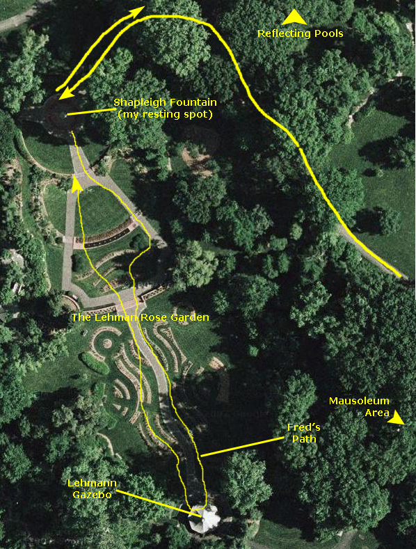 |
We came around close to the Climatron, and then walked a short ways west to the Shapleigh Fountain. You can see the fountain in the aerial view at left, but at the time of day we were here, the fountain was in bright sunshine. Roses not being so much my thing, I thought I would just rest on the marble arc by the fountain and let Fred investigate the Lehmann Rose Garden to his heart's content. I waved goodbye and off Fred went. (Unbeknownst to me, Fred got a picture of me snoozing by the fountain on his way back.)
The Anne and John Lehmann Rose Garden, established in 1974, has been called the more romantic of the two rose gardens, with a bushy mix of old floribunda, shrub roses and others. It is less formal than the Gladney Rose Garden, and contains about 1,350 roses representing 160 different varieties.
The Lehmann Rose Garden also mixes the delight of aromatic flowering plants and water; the Shapleigh Fountain is set in a circular brick plaza 50 feet in diameter with three curtains of water that rise and fall.
Fred, of course, walked the entire length of the Lehmann Garden. At the upper level of the garden, he found the Lehmann Gazebo with a fountain and pool, offering a shady respite during peak blooming time. He presumed that in the spring, the thick azaleas that flanked the gazebo would be extremely colorful.
Edging the first terrace is the Kercheval Pool, a low bubbling fountain. The middle tier contains the All-American Rose Test Center, where new roses are evaluated in the AARS program. A mix of very fragrant old garden roses, species roses and perennials grow on the lower terrace, showing how roses can be featured among other plants. Off to the east side, Fred took an artistic picture of the Robert Lee Walker sculpture "Birds," that was made in 1975 and donated to the gardens by a patron.
I wasn't actually sleeping, so I heard Fred return. Just before we left the rose garden, I took a picture of the Lehmann Garden from the Shapleigh Fountain all the way to the gazebo in back, and you can see that picture here.
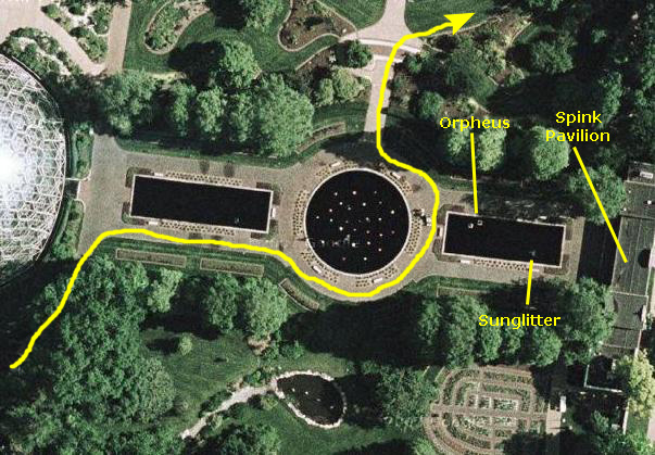 |
Spink Pavilion and Reflecting Pool
There are two sculptures in the pool itself. The first one is "Orpheus Fountain." It was created in 1936 by Carl Milles.
Also in the reflecting pool, and also created by Carl Milles is "Sunglitter," which depits a mythological Nereid, or sea nymph. Milles created this work in 1918.
We left the reflecting pool via the walkway back to the Gladney Rose Garden, but we angled off around the garden to get to the area to the east of the Linnean House.
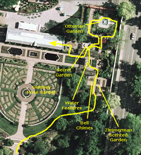
Linnean House Gardens
Zimmerman Scented Garden
Water Features
Secret Garden
Ottoman Garden
 |
I made a movie of Fred trying out the bells (there was no wind to move them), and you can watch that movie using the player below:
|
|
Just past the Zimmerman Garden is an area at the east end of the lily ponds alongside the Linnean House. The area is, apparently, called the Swift Family Garden. The garden consists of a trellised section in the shape of an "H" that has a pool in the middle and some shaded sitting areas alongside. Crossing the pool at the center of the "H" is a steppingstone walkway, again covered by a trellis. As you cross the walkway, you can see just to the side a sculpture by the Italian artist Sirio Tofanari entitled "Three Sturgeons." The sculpture is undated. Tofanari was self taught, working first in Florence and then in Milan. Tofanari won a reputation for animal sculptures, but unfortunately most of his work was destroyed during World War II. You can see Fred on the steppingstone walkway here. On the north side of the walkway, part of the Swift Family Garden was a totally enclosed and very quiet secret little garden; there was only a small entrance to it, and I suspect a lot of folks miss it entirely.
|
|
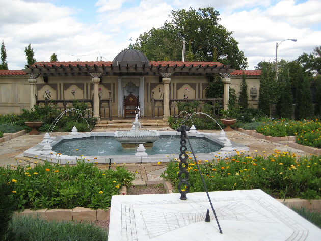 |
| The Bakewell Ottoman Garden |
The plants represent what would have been grown in the 16th through 19th centuries in what is now Turkey. St. Louis and Istanbul lie roughly at the same 40-degree latitude. The Ottoman Garden has tried to preserve the authenticity of the period. There is a stone pedestal fountain, or cheshme, a traditional method of cleansing the hands, and there was also in inlaid vertical marble slab with a faucet and bowl for washing one's feet. You can see Fred standing beside it here.
There were brick walkways leading us through the flower-laden plots to the center fountain. Next to the fountain, there is a raised, paved patio covered with a wooden arbor, or chardak, with a tiled roof and small dome, and there is what appears to be a throne, or a chair for the sultan, I suppose. The walls displayed classic Ottoman murals of flowers.
Final Stops at the Missouri Botanical Garden
 |

|
|
|
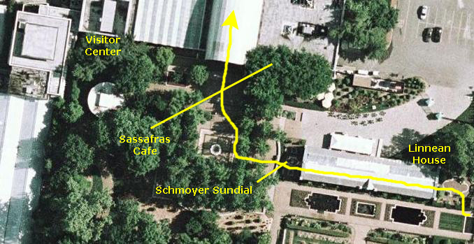
Coming out of the Linnean House we crossed a small patio between it and the Visitor Center. Here, we came across the Schmoyer Sunquest. This unique sundial displays daylight-savings time. The movable part on the dial's axis casts a shadow. Time is indicated by a band of sunlight between two shadows on the time scale, when the red ball is turned so that the appropriate side (winter/spring or summer/fall) faces the sun, and the face is brought to a position at right angles to the direction of the sun's rays.
As I said earlier, we went into the Sassafras Cafe and got a late lunch, eating it as we sat out on the terrace. It was nice in the sunshine. That about concluded our visit to the Missouri Botanical Garden, and our next stop was the Gateway Arch downtown.
The St. Louis Gateway Arch
 |
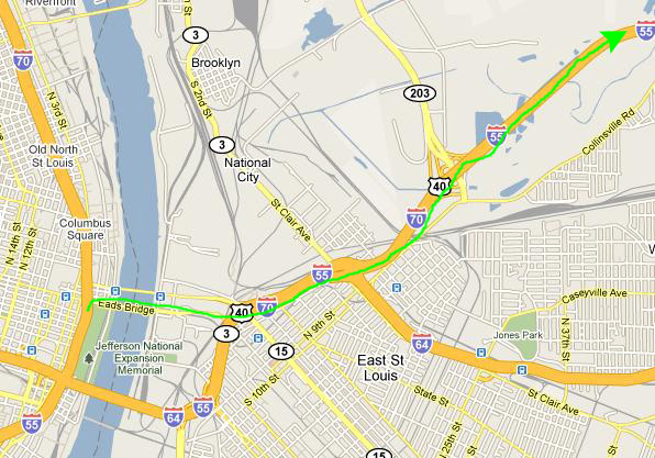
Getting to the arch from the Botanical Garden was easy; actually, the only tricky parts were exiting the Gardens and getting on the expressway and then exiting at the right street downtown. But it was a quick fifteen minutes on I-44/I-55/I-70 and we were there.
 |
|
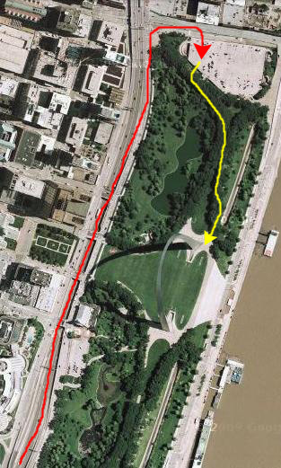
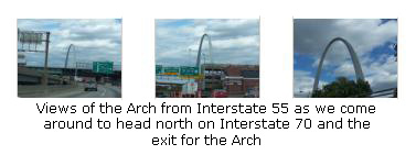
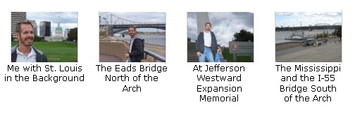
We took the exit for the Eads Bridge and got on the surface street that led to the parking garage for the Arch. When we got upstairs, we were at the north end of the park, and all we had to do was follow the broad walkway through the trees and past a lake to come to the base of the Arch itself. Just as we came out of the trees, we got some excellent views of the arch from the side, where you can't see the perspective, and then we moved a bit to the side to bring the other part of the Arch into view. There are thumbnails for some of these pictures below; click on them to view the full-size pictures:
|
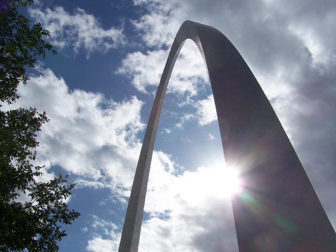 |
The Gateway Arch is known as the "Gateway to the West." It was designed by Finnish-American architect Eero Saarinen and structural engineer Hannskarl Bandel in 1947 and built between 1963 and 1968. It is the only building in the world based on the catenary arch, making it the iconic image of the city. It stands 630 feet tall and 630 feet wide at its base. The legs are 54 feet wide at the base, narrowing to 17 feet at the arch. There is a unique tram system to carry passengers to the observation room at the top of the arch. I had not been here before, and I was simply amazed at both the beauty of the Arch and the feats of engineering that brought it into being. Looking at it from below, I was wondering if I would be able to take the tram up to the top, so fragile did it look from down here. I was definitely impressed, although to the locals the Arch seems to be old hat. (Incidentally, if you look very closely, blowing up the picture if you need to, you can see the Arch reflected in his eye!)
We wandered around the base of the Arch for a while taking some more pictures, and some of these turned out rather well. I have put thumbnails for them below, and you can click on the thumbnails to view the full-size images:

|
To get into the Arch, there are two sloping walkways that lead down underground, and these walkways start at the northern and southern bases of the arch. We didn't take a picture going in, but Fred took a picture of me in the northern walkway as we went out, and you can see that picture here. As you come down the ramp into the huge area underground (the museum, a restaurant and a gift shop are located here), you pass on either side of an opening that contains another ramp, leading further down, in the opposite direction. It may be a bit confusing, since we used only the north entrance, but you can see a picture of Fred standing at the base of the southern ramp here.
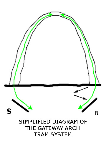 |
It is true that the slope of the tram is counterintuitive, but only if you think of the tram as a straight line that can't bend- like a tram up the side of a mountain. But this tram is different. It consists of eight "pods" that are actually not attached to each other in any kind of fixed, rigid way. Imagine that they are attached with a flexible cord that will allow one to pull the other like railroad cars around a curve. In fact, that's not a bad way to think of the tram system. Lay the arch on its side and you'll see what I mean. The pods are now exactly like railroad cars; the first one pulls all the others. And if you'll also imagine that someone has laid train tracks inside the Arch for the pods to ride on, then you've got it. All you have to imagine is that there are tracks on both sides of each pod like, say, a garage door. And the tracks, just like a garage door, follow the slope of the Arch.
So our train started by moving up and to the north, but then the track curved, and we rotated around through the vertical and ended up going upwards but to the south. That's really all there is to it. Oh, I guess you might wonder how we stay upright in the pods throughout the trip, if we're riding on rails and the pods don't move in relation to each other. The final piece of the puzzle, and what makes the story of the tram's design so interesting (you should Google "Jefferson National Expansion Memorial Tram" and find the essay written by the tram's designer) is the concept of a Ferris wheel. The pods are actually not dangling from some overhead structure; that wouldn't have worked. But they are free to gimbal in response to gravity as they move along their course. (The folks loading the pods were heard to caution visitors in partially-filled pods to spread out so that the pod would remain as close to vertical as possible.)
If you're a Star Trek fan, you might recognize some design elements of the "turbolift," which doesn't just go up and down (relative to the ship), but also moves horizontally and diagonally on each deck. (Just don't stop to think how much space within the Enterprise must be taken up by turbolifts!)
So that's how it works. The actual ride up to the top of the Arch was anticlimactic. No, seriously, it was amazing. Below are the movies that I took of our trip up to the top of the Arch:
|
|
|
|
When we got to the observation room at the apex of the Arch, we found a long, thin room with a carpeted ledge along both sides and small, thick windows (sixteen of them on each side) for viewing. To take pictures through them, one had to lean up against the window over the ledge, but when I did this (repeatedly) I couldn't shake the feeling that if I pushed real hard the whole Arch would just fall over. And I'd swear I could feel the Arch sway a bit from side to side. It was all a bit disconcerting and it took some getting used to, but I just kept telling myself that millions of people, most of them heavier than me, have been up here, in winds higher than today's relative calm, and nothing has happened. That helped. Somewhat.
Anyway, we took quite a few pictures here inside the observation area, and had some taken of us by others. There is not a lot I can say about the individual pictures; they are pretty self-explanatory. Some of them were taken by obliging fellow tourists. I have put thumbnails for the best of these pictures below; click on as many of them as you wish to view the full-size pictures that interest you:

|
Of course, the main reason anyone comes up here and takes their life in their hands and risks a collapse of the Arch and looks sudden death in the face (oops, my paranoia and OCD are showing) is the view, and the views are certainly spectacular. I can't recall a high place in a man-made structure that has such amazing views for such long distances. You can only look two ways, though. One is basically west at downtown St. Louis. The other is basically east at the Mississippi River and Illinois. I don't know all the buildings downtown, so I won't try to supply labels for the pictures we took in that direction. But here are thumbnails for the best of all the downtown pictures we took; click on them to view the full-size images:
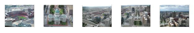
|
Looking out the other side of the Arch, the view was of the Mississippi and downstate Illinois. Downstate Illinois is pretty flat (actually, ALL of Illinois is pretty flat). It's been said that if you drive from Chicago to Denver you are about 90% of the way there before you have risen to the height of the Sears Tower in downtown Chicago- about eight hundred miles away. But we took some pretty nice pictures and I've put thumbnails for them below. Click on the thumbnails to view the full-size images:

|
Being up in the Arch was really neat; I'm glad I finally got the chance to do it. We lined up for the tram going down (the next one being the south tram), and presently found ourselves back in the underground complex. Our next stop was the museum, it being focused on the westward expansion of the country. There were lots of interesting exhibits, and we took lots of pictures. With many items in glass cases, flash didn't always work well in the dimly-lit museum, but we did the best we could. Below are thumbnails for some of the pictures we took in the museum. Click on them to view the full-size images:

|
|
|
One last stop we made was in the gift shop (Levee Mercantile) to pick up some Arch souvenirs. Hey, it took me almost 30 years of traveling to St. Louis to get here; who knows when I'll be back? Then we headed back outside into the cloudy late afternoon. It had turned pretty overcast since we left the Botanical Garden and, as it turned out, it got rainy and much cooler before we got to Chicago.
But for now, we walked around the east side of the park getting some more amazing views of the Arch towering above us. We walked down a broad set of stairs to the esplanade by the Mississippi and in general just took our time admiring the views along the river and of the Arch.
|
At the left are thumbnails for four of the best pictures we took while we were walking around; click on them to view the full-size images.
|
|
Our visit to the Arch was over; it had been a pretty amazing experience. Just before we had gotten back to the parking garage, we left the paved walkway and went down to the shore of the lake that lies in the park north of the Arch itself. Here, we got one last iconic picture of The Gateway Arch. Then we hopped back in the car, turned on the GPS and headed for Chicago. Not that I needed to be told the way. Instead of going south of the Arch to the I-55 bridge, we just took the Eads Bridge north of the parking structure to get over to Illinois. As we were crossing the bridge, Fred looked back and snapped one last picture of the Arch.
 |
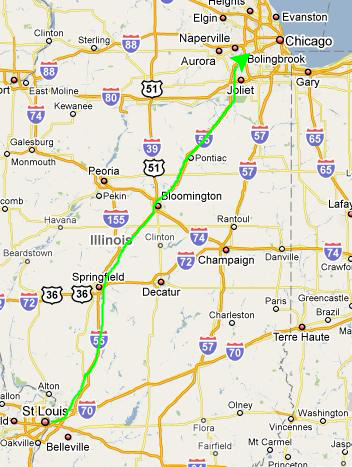 |
So that's what we did, following I-55 north through Springfield and Bloomington.
 |
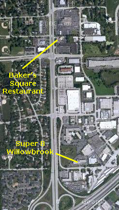
We got off at Illinois 83 and turned north a half-mile or so and then turned right back around onto the frontage road and the Super 8 Willowbrook. It was an OK place, fortunately with interior halls (much more common up north).
 |
We had a good meal and afterwards headed back to the hotel. We'd done a lot today, but I was looking forward to getting to Chicago tomorrow.
You can use the links below to continue to another album page.
|
October 3, 2009: Chicago, Illinois |
|
Return to the Index for Our Midwest Trip |