|
Return to the List of Walks in Cadiz |
 Click on the button above to bring up the map for this walk. |
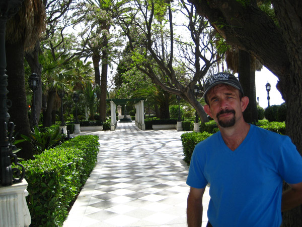
When we ended our "Shippers to the Indies" walk, we returned to the ship with Greg for a late lunch. We relaxed for just a while, and then Fred and I disembarked again to see how much of the final Cadiz walk we could complete before it was time to return to the ship.
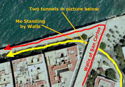
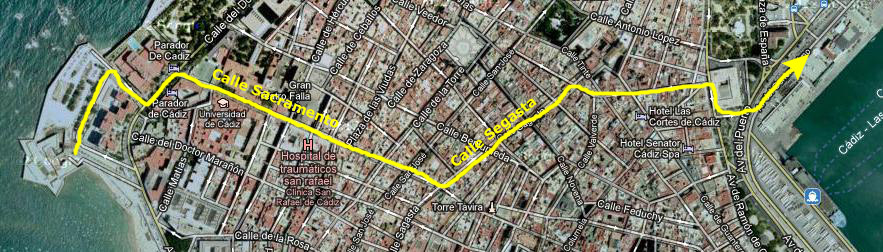
If you will open up the Castles and Bastions Route Map, use the horizontal scroll bar to go all the way to the right. You will be near the harbor and will see the orange walk coming up from the Tourist Center. Since there were no stops between the Tourist Center and the closest point to the ship, we just headed directly west from the ship to intersect the line before the first stop.
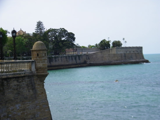
Stop 1: Murallas San Carlos
|
|
The San Carlos walls close in the neighborhood of the same name. Their construction was completed in 1784, according to the records kept by military workers on the project. These walls form a semi-bastion that was constructed at the end of the 18th Century by the military engineer Juan Caballero. From the middle of the 16th Century the San Felipe Bastion occupied part of this urban area. At the end of the 18th Century the governor of the city, Count O'Reilly, built the San Carlos district over this site, whose design follows Enlightment principles.
|
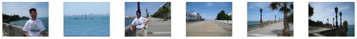
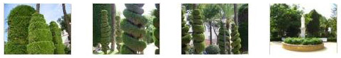
But we also wanted to get up onto the battlement, since we'd already been along this street, so we returned to the stairs and climbed up onto the top, and walked first towards the bay and then along it. This is the red line in the aerial view. The walls, as you saw earlier, had those turret-type affairs every so often. These were observation/firing positions, and you can see what one of them looked like from up on the walls here. As we continued west along the top of the walls, the street below us was sloping upward, so when we got to the west end of the wall we were back at street level. We took some pictures along this part of the walk, and there are clickable thumbnails below for them:
|
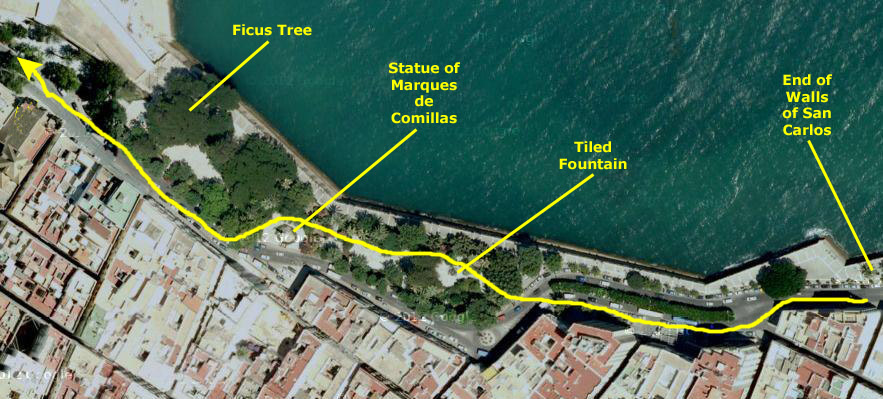
At the end of the walls we found ourselves at the beginning of the Alameda Apodaca.
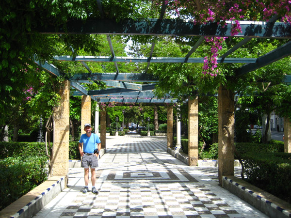
Stop 2: Alameda Apodaca
|
|
It has undergone several renovations, and the park reached its current form in 1926, when fountains and statuary were added. The most important monument in the Alameda Apodaca is the statue of the Marques de Comillas, who was a shipping magnate and constant promoter of Spanish-American relations. The statue was completed in 1922 and is a work of Antonio Parera.
There was also a statue of Brother Diego of Cadiz (1743-1801), a saint and moralist. The lush vegetation of the Alameda is also worthy of mention, with the flagship being the huge ficus tree located next to the Bastion de la Candelaria.
Below are some thumbnails for other interesting pictures we took here in the park:
|
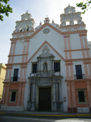
Stop 3: Iglesia Nuestra Senora del Carmen y Santa Teresa
|
The church takes the form of a Latin cross, with a central nave that is higher than the sides; the sides of the nave contain numerous small chapels dedicated to those who supported the building of the church. The nave has a barrel vault and there is a wooden altarpiece- gilded in the rococo style- with the image of the Virgen del Carmen.
The facade is very slender, with three sections with pilasters, but leaving large spaces free of decoration. It concentrates on the cover of marble, with two Ionic columns, garlands of flowers and a relief of the Virgin of Carmen. Also noteworthy are the two belfries crowning the facade, which show all the fantasy of baroque decoration.
You can see another nice image of the facade here.
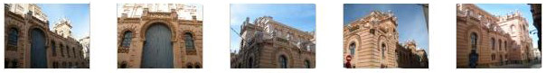
Stop 4: Baluarte de La Candelaria/Candelaria Bastion
|
The bastion contained barracks and an arsenal, in addition to the turrets and battlements normally found in such a fortress. It has been restored and is now used as cultural space. There are plans to create a sea museum which will host permanent exhibitions of Cadiz's place in Spain's seafaring endeavors. Below are clickable thumbnails for some additional pictures we took of the bastion:
|
Stop 5: Centro Cultural Reina Sofia (the old Pavilion of Engineers)
|
Today, this building, which sits just south of the bastion and on the ocean, houses the Municipal Foundation of Culture, the Permanent Exhibition Vassallo, a space available to the Army, the Royal Academy Hispano, Fundaci�n Federico Joly and the Ateneo de Cadiz. Out front, there is also an interesting modern sculpture.
Stop 6: Facultad de Filosofia y Letras (Faculty of Arts)
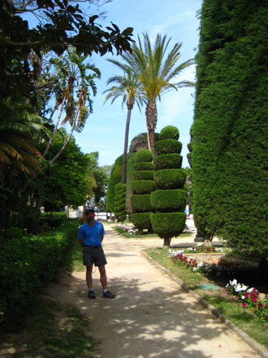
Stop 7: Parque Genoves
|
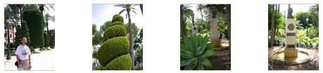
Below are clickable thumbnails for a few more pictures taken in the Gardens of Carlos III:
|
Genov�s Park is the largest, the most historically important and, to hear the locals tell it, the most interesting and relaxing in Cadiz. It has its origins towards the end of the 1700s, although throughout its history it has undergone numerous expansions and renovations.
|
In 1863 the park was pretty much demolished, the site re-prepared and then repopulated with leafy trees of different species, which were dominated (according to contemporaneous documents) by American Cypress. In 1875 and because of the spacious and well-done park renovations, it became the site for the yearly holiday commemorating the evening of the Angels. A further remodeling was carried out in 1892 by the Valencian horticulturist Geronimo Puig i Genov�s; in his honor, the name of the park was changed to the current Genov�s Park.
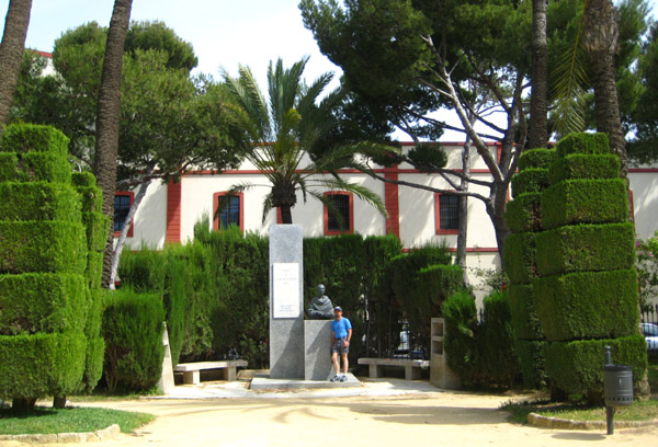
His renovations were based on the old garden layout, but he expanded the so-called "Forest Army," providing it with fountains, a waterfall with lake, a concert hall and cafe, and a much greater variety of plant species- some of them of great rarity and beauty. He installed the sculpture fountain "Children Under the Umbrella," which was brought from Paris. There are also several sculptures dedicated to Celestino Mutis, the Duchess of Victoria (a noble lady who left Cadiz and gave up her comfortable, pleasant life to care for the wounded from the war in Morocco). Also worth noting is the monument dedicated to the great naturalist Felix Rodriguez de la Fuente.
In the late 19th Century, a performing theatre was added; its metal structure was the work of Gustave Eiffel. There was also another theater for summer productions; it was named after Jos� Mar�a Pem�n (his statue is also in the park). There was even a famous nightclub- the Cortijo de los Rosales- in the park, but it closed in 1970.
|
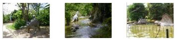
One of the favorite places for all visitors is The Pit, a lake and waterfall with live ducks and geese. Oddly, the small lake is populated also by dinosaur sculptures. Visitors can get up on top of the waterfall, and from there one has good views of the Atlantic Ocean and north and south along the coast. There is also a tunnel that goes underneath the waterfall, and this, too, is a park favorite- particularly for kids.
Below are clickable thumbnails for some of the other pictures we took here in Parque Genoves;
|
If you are a horticulturist, you might be interested in knowing some of the plant species found in Parque Genoves. Here is a partial list:
| Common cypress (Cupressus sempervirens) | California Cypress (Cupressus macrocarpa) |
| Date palm (Phoenix dactylifera) | Enough cassava (Yucca aloifolia) |
| Cassava (Yucca gloriosa) | Cotyledon (Cotyledon orbiculata) |
| Dragon's Agave (Agave attenuata) | Japanese bush (Portulacaria afra) |
| Cr�sula (Crassula arborescens) | Aloe (Aloe ciliaris) |
| Schefflera (Heptapleurum arboricola) | Duranta (Duranta repens) |
| Magnolia (Magnolia grandiflora) | Duster (Cortaderia selloana) |
| Tree of Love (Cersis siliquastrum) | Aralia (Oreopanax capitatus) |
| Maple (Acer negundo) | Privet (Ligustrum japonicum) |
| Araucaria (Araucaria excelsa) | Dragon tree (Dracaena draco) |
| Aleppo pine (Pinus halepensis) | Casuarina (Casuarina equisetifolia) |
| Pink Bignonia (Podranea ricasoliana) | Bougainvillea (Bougainvillea glabra) |
| Eucalyptus (Eucalyptus globulus) | Red Bignonia (Tecomaria capensis) |
| Aspen (Populus tremula) | Opuntia (Opuntia vulgaris) |
| Canary Island pine (Pinus canariensis) | Cica (Cycas revoluta) |
| ichardia (Washingtonia robusta) | Washingtonia (Washingtonia filifera) |
| Hackberry (Celtis australis) | Elm (Ulmus sp.) |
| Veronica (Hebe speciosa) | White poplar (Populus alba) |
| Spindle (Eyonymus japonicus) | Palo borracho (Chorisia speciosa) |
| Alexandrian Laurel (Ruscus hypoglossum) | Butcher's Broom (Ruscus aculeatus) |
| Corifa (Livistona australis) | Algarrobo (Ceratonia siliqua) |
| Laurel (Laurus nobilis) | Tapeworm (Muehlembeckia platycada) |
| India's Laurel (Ficus microcarpa) | False pepper (Schinus molle) |
| Arizona cypress (Cupressus arizonica) | Mimosa (Acacia cyanophylla) |
| White Salt (Atriplex halimus) | Marjoram (Majorana hortensis) |
| White mulberry (Morus alba) | Rosemary (Rosmarinus officinalis) |
| Izote (Yucca elephantipes) | Brilliant (Coprosma baueri) |
| Flag of Spain (Lantana camara) | Cylindrical Opuntia (Opuntia subulata) |
| Bitter orange (Citrus aurantium) | Pit�sporo (Pittosporum tobira) |
| Hibiscus (Hibiscus rosa-sinensis) | Jacaranda (Jacaranda mimosifolia) |
| Fig (Ficus carica) | Quince (Cydonia oblonga) |
| Ombu (Phytolacca dioica) | Metrosidero (Metrosideros tomentosus) |
| Black locust (Robinia pseudoacacia) | Coculo (Cocculus laurfolius) |
| Pomegranate (Punica granatum) | Lira Ficus (Ficus lyrata) |
The rarest species in the park is the New Holland Sago (Cycas circinalis).
I found the waterfall and the dinosaurs a really neat feature, and we spent a good deal of time wandering around there.
|
|
Here are some clickable thumbnails for three more of our "dinosaur pictures:"
|
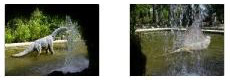
There was a path that went around the side of the artificial cliff and there we found stairs up to the top. We went on up and was rewarded with nice views of the ocean and down into the artificial lake.
Back down at the bottom of the stairs we found that the path continued into the hollow interior of the artificial cliff where you could get behind the waterfall, so of course we went in.
|
|
And, although they aren't anything you haven't already seen, Fred took a couple of pictures through the "windows" behind the waterfall, and there are clickable thumbnails for them below:
|
By this point, we were at the south end of the Parque Genoves, so we went back out to the avenue to pick up the yellow line again.
Stop 8: Plaza Fragela
|
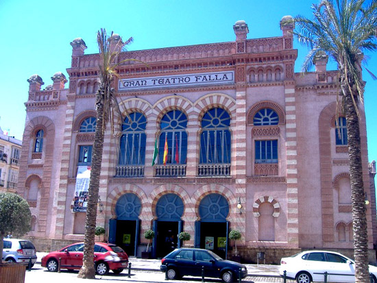
Today, the square is again undergoing a transformation intended to restore the old appearance (including refashioning the gardens, which had gone downhill as the congestion of the city increased. In this square, in addition to the theatre, are a notable building originally called the Widows House for the obvious reason, the building housing the Faculty of Medicine at the University of Cadiz (the oldest in Spain) and the Military Chapel. Off to the side we didn't visit there is probably the only public sculpture I have ever heard of that honors an ophthalmologist (D. Cayetano del Toro); I should have known so I could have gotten a picture.
You may find them repetitive, but we took some additional pictures of the sides and back of the Gran Teatro, and there are clickable thumbnails below for them:
|
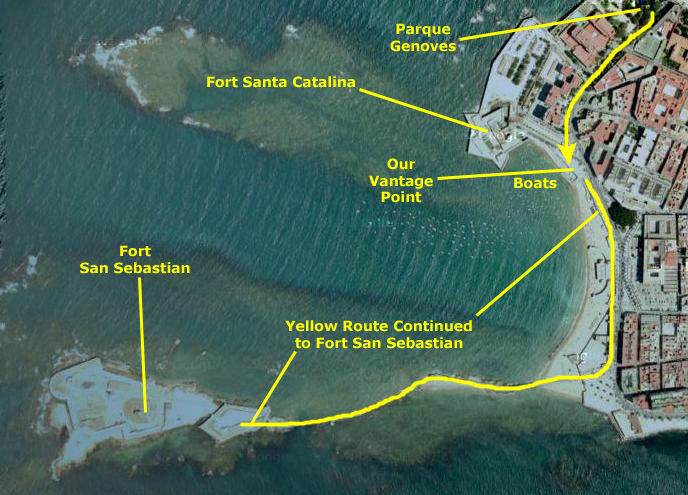
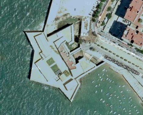
Stop 9: Castillo de Santa Catalina
|
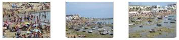
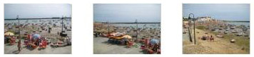
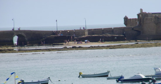
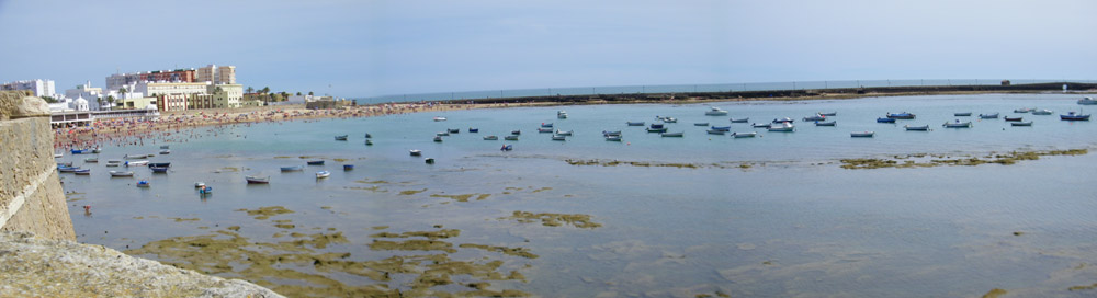
We'd come down the Avenida Duque de Najera to a point just past the street that led to Fort Santa Catalina. Here, a wide paved area began that ran in an arc south and around the beach/bay/boat harbor known as Playa la Caleta. The area was very busy, but as you can see, the tide was out and many of the little boats that seem to be usually tied up here (mostly at the north end of the area) were high and dry.
It took me a while to figure out what was so unusual about this beach scene, but even when I did, I was at a loss for an explanation (and I still am). Perhaps it has occurred to you. If not, take a look at this picture that Fred took of me along the beach south of here early this morning when we were beginning our first walk (click here). See it now? I can't recall ever seeing a picture of people at the beach when there were no waves at all (unless the beach was on a lake, perhaps). This didn't seem like an inviting place, what with the tide out and all, but there were lots of people walking around on what I can only assume was mud, and seeming to have a good time doing it.
Actually, looking closely at the pictures, the bottom of the inlet might actually be rock, in which case walking around on it wouldn't be as gross as I might have thought, but still, you'd think people would find a beach that isn't unusable half the day (when the tide is out).
|
Movie Title |
And because I thought the scenes of a beach with lots of people and not much water to speak of was so interesting, I want to include more of the pictures we took from here. There are clickable thumbnails below for them:
|
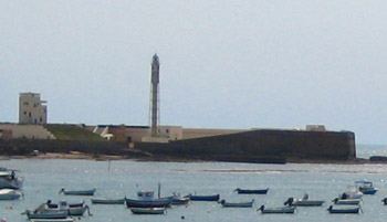
From this vantage point, we could see the 9th and 10th points of interest on the Castles and Bastions walk. One of them, Fort San Sebastian (seen here from our vantage point across the bay), would be the one point that we wouldn't have time to get to. We could see how far away it was, and even a quick calculation told us we'd be cutting it too close if we tried to get down there. We did take some other pictures of it from here and from Fort Santa Catalina, but I'll put them in the next section devoted to that point of interest. Looking in the other direction, just off to our right, we could also see Fort Santa Catalina, sticking out into the bay just a few hundred feet away. That fort we would have time to visit, and we'll do so in a moment. But first, I want to include here a very nice panorama that Fred made by stitching some pictures together, and it is below:
|
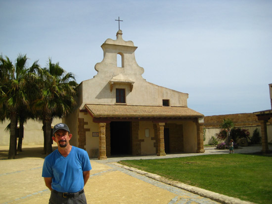
It was time to head over to the Castillo de Santa Catalina for a look around. You can see most of Fort Santa Catalina behind Fred in this picture I took just before we headed over there from our vantage point overlooking the beach. We headed down the walkway to the fort, stopping so Fred could take my picture with a really interesting sculpture. Then we continued walking down to the entrance to Fort Santa Catalina.
|
|
In 1769, Carlos III established a military prison in the fort. Over the years, a number of different groups of people were held here, most of them having been involved in the wars of independence for the Spanish colonies in America. Most recently, some of the people involved in the attempted coup in 1981. (The attempted coup d'�tat began on 23 February 1981 and ended on the following day. Its most visible figure, Antonio Tejero, led a group of 200 armed officers of the Guardia Civil into the Spanish Congress of Deputies during the process of electing Leopoldo Calvo Sotelo to be the country's new Prime Minister. King Juan Carlos I gave a nationally televised address denouncing the coup and urging the maintenance of law and the continuance of the democratically elected government. The coup soon collapsed. After holding the Parliament and cabinet hostage for 18 hours the hostage-takers surrendered the next morning without having harmed anyone.) Military use of the fort ended in 1991.
Below are clickable thumbnails for some of the pictures that we took while we wandered up and down the walls, out to the turrets at the points of the star, and inside the Fort of Santa Catalina:
|
|
|
|
|
Stop 10: Puerta de la Caleta y Castillo de San Sebastian (Fort San Sebastian)
|
|
In 1860, the city built a boardwalk to link the island and the center of the city, and the entire complex was declared a national cultural monument in 1985.
Stop 11: Barrio de la Vina
The Walk Ends
|
Walking back, I found it really amazing how different the neighborhoods and streets are here in the old city of Cadiz. You can see what I mean if you watch the two movies I made on the way back- one on Calle Sacramento and one on Calle Segasta:
|
Walking Along Calle Sacramento |
Walking Along Calle Segasta |
To return to the main page for our stop in Cadiz and to follow us on another of our four walks, please click
|
Return to the List of Walks in Cadiz |