|
September 27, 2013: Our Trip Home |
|
September 25, 2013: Walking Galway and Return to Dublin |
|
Return to the Index for Our British Isles Trip |
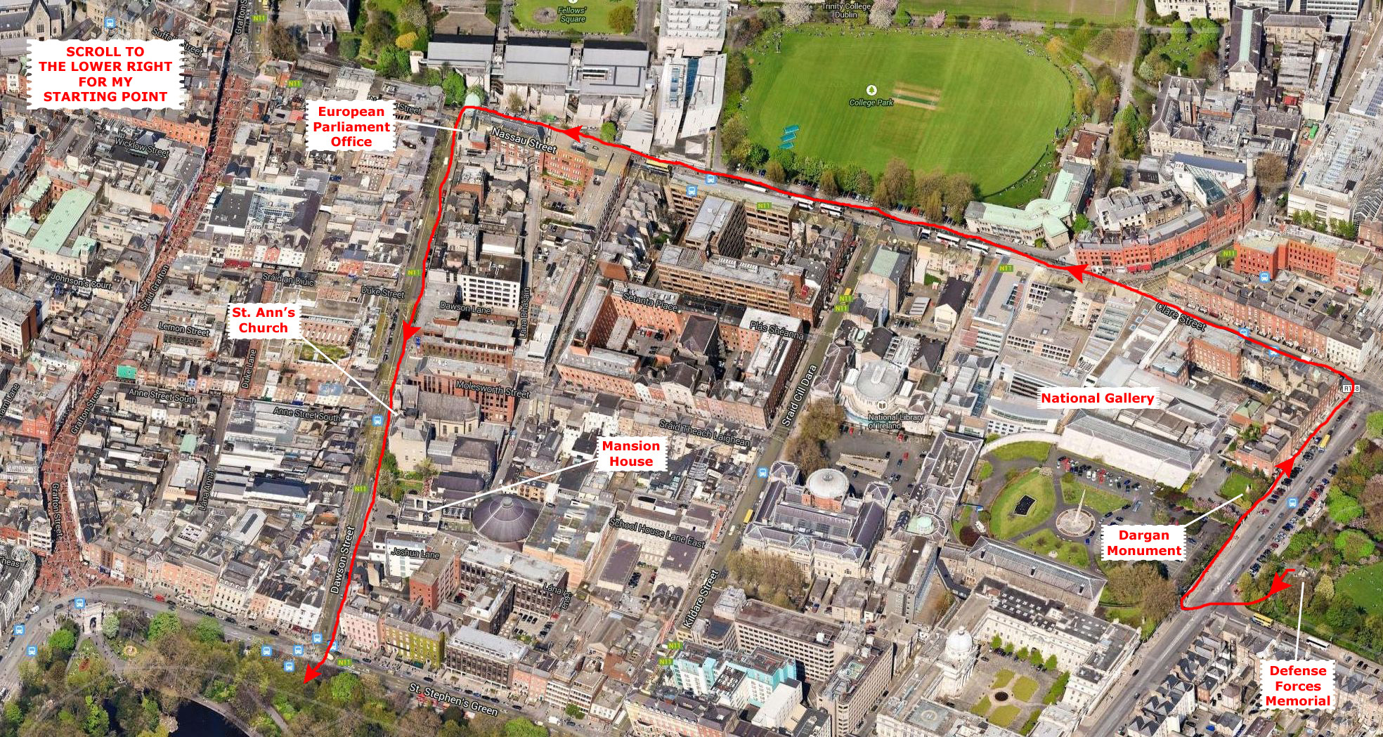
We had hoped the weather would be pretty today, but morning dawned cool and drizzly. This didn't faze the group, save for me, as they wanted to see a few museums and mostly indoor things. I, on the other hand, had wanted to walk as much of the city as I could, and see as many sights as possible. So I made a decision, and would let everyone else head on out after breakfast while I waited for a bit at the Ariel House for the weather to clear. If it didn't, I knew where they were headed and might join them.
They had been gone for over an hour when the weather cleared a bit and it stopped raining. It was still cloudy and a little dismal, but I decided to take my jacket and my umbrella and head out on a walking tour. I had a Dublin tourist map, and I had spent the hour plotting a route I might take to make a big circle and eventually return to the Ariel House.
So this page will be a bit unusual. I'm going to structure it in order of the major points of interest on my own walk, and so the pictures will all be mine. If the rest of the group happened to visit the same place, I'll include their pictures as well. After I've brought you back to the Ariel House at the end of my own walk, I'll add sections for points of interest that everyone else visited but I didn't.
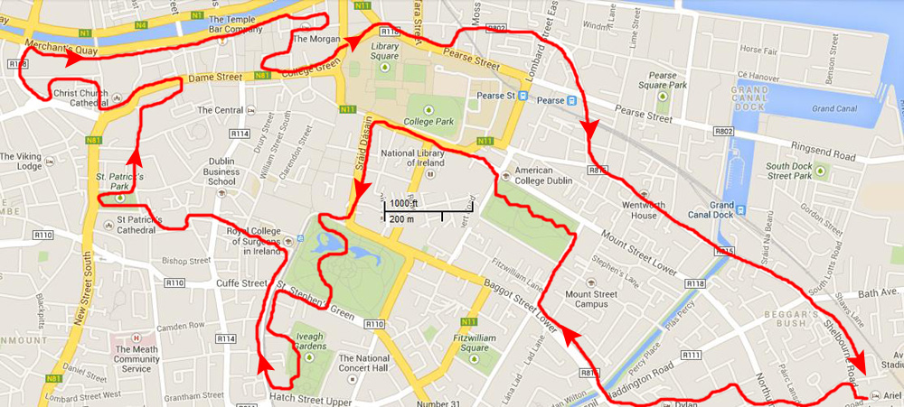
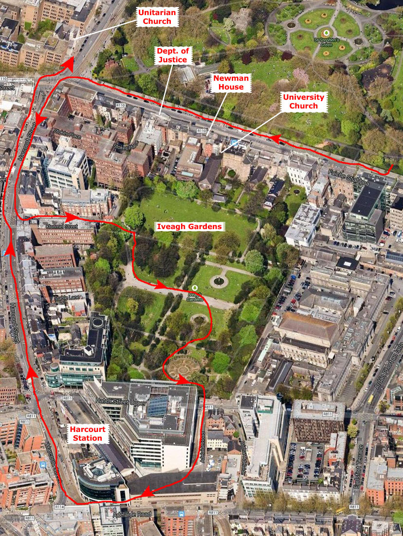
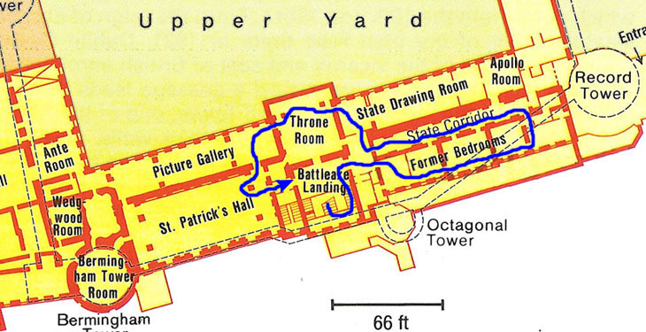
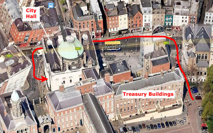
Since I was on my own, I can't really show you the other folk's followed, so I won't attempt to piece it together from their pictures. But for my own route, I'll do what I've done before in this album- provide you with a 45° aerial view of the part of Dublin that I covered. I plan to cover a great deal of ground, though, and so I think that scrolling through one huge aerial view will be impractical. So for each section, I'll put just a section of the overall view, but each one will pick up where the previous one left off. I'll do my walk first, then return for the walk the others took.
So with all that in mind, let's head out and see some of Dublin!
We'll do my walk first.
|
If you do a rought approximation using that scale, you'll see that the walk covered approximately seven miles. I could wish the weather would have been better; gray skies make pictures kind of dismal-looking, but the day was what I had to work with.
I'll mark the places that I visited in red.
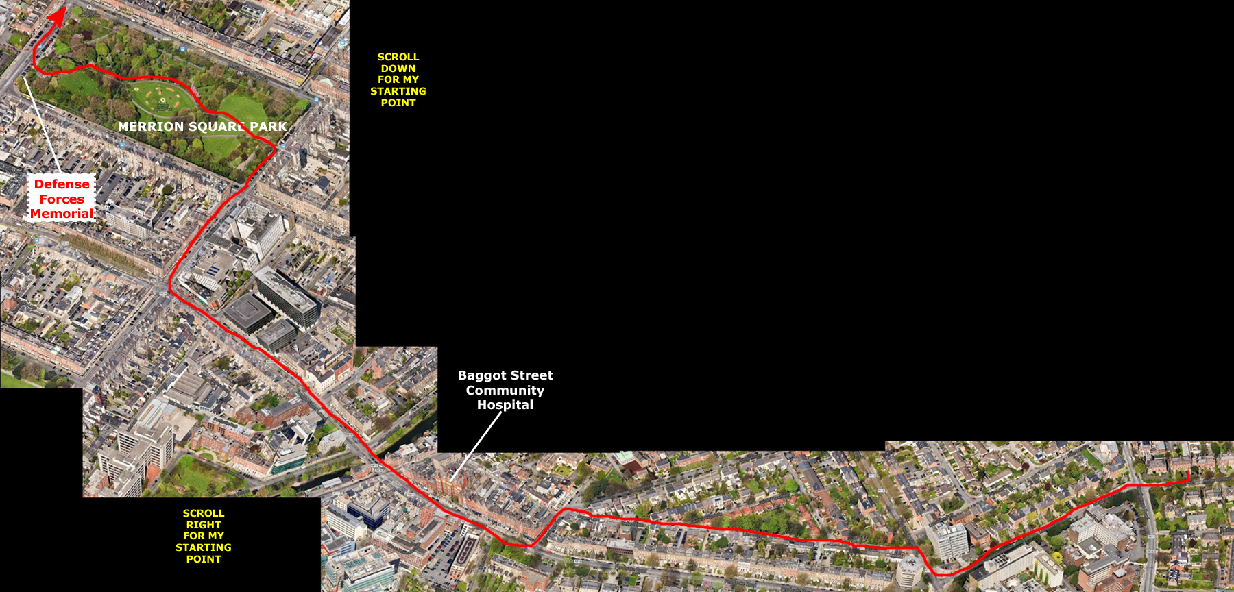
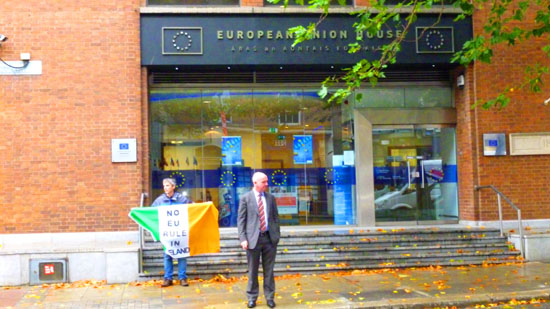
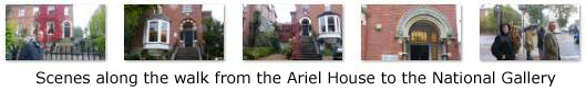
I began by leaving Ariel House and heading west on Landsdowne, working my past the Dylan Hotel, where we stayed three nights ago, to Baggot Street into the city center.
Merrion Square Park
|
From the Ariel House, I walked generally west, jogging through the streets towards Baggot Street that would lead me across the Grand Canal and into the center of Dublin. As chance would have it, I found myself at one point coming right in front of the Dylan Hotel where we had stayed three days ago on our arrival in Ireland.
From there, I jogged down to Baggot Street and followed that northwest across the canal, passing the Baggot Street Community Hospital, a building we'd seen on our evening walk from the Dylan Hotel. When I got to Lower Fitzwilliam Street, I turned right and continued along until the entrance to Merrion Square Park was on my left.
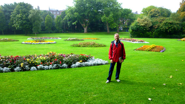
I crossed the street into the park heading west. I immediately came to a fork in the pathway and, making a random choice, took the right-hand (north) path, crossed through some trees and came into the center of the garden.
Merrion Square is a Georgian garden square, laid out after 1762 and largely complete by the beginning of the 19th century. It is considered one of the city's finest surviving squares. Three sides are lined with Georgian redbrick townhouses; the West side abuts the grounds of Leinster House (seat of Ireland's Parliament), Government Buildings, the Natural History Museum and the National Gallery. The central railed-off garden is now a public park.
|
The square was leased to the Archdiocese of Dublin by the Pembroke Estate in 1930 to permit the building of a cathedral, but when no progress was made, the site was transferred to the city of Dublin in 1974. Now public, the park contains a statue of Oscar Wilde, who resided in No. 1, Merrion Square from 1855 to 1876, many other sculptures and a collection of old Dublin lamp standards. The Irish American sculptor Jerome Connor, best known for his work Nuns of the Battlefield in Washington DC, designed the public art piece, "Eire". The park also contains a sculpture of a Jester's Chair in memory of Father Ted star Dermot Morgan.
Just after I asked an obliging tourist to take the picture above, I thought I would try to create a panoramic view of the center portion of the park. So I took three pictures and stitched them together. The result is below:
 In the Center of Merrion Square Park |
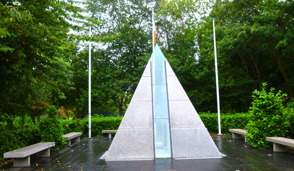
I continued westward through the park to its edge, and then saw a couple of sculptures down in the southwest corner, and so walked down there.
|
From a distance, it is hard to see the figures inside the memorial; you have to go right up to the sealed glass windows to look in. When you do, you can see the sentries and eternal flame.
The next place I wanted to visit was another park- St. Stephen's Green. To get there, I wanted to take a circuitous route past some other sites marked on my tourist map, so I headed off.
Walking from Merrion Square to St. Stephen's Green
|
William Dargan (1799�1867) was an Irish engineer who designed and built Ireland's first railway line from Dublin to D�n Laoghaire in 1833. In total he constructed over 800 miles of railway to important urban centers of Ireland. He was a member of the Royal Dublin Society and also helped establish the National Gallery of Ireland. He was also responsible for the Great Dublin Exhibition of 1853. In addition to this monument, Dublin's new cable-stayed bridge for its light rail line was named after him.
I continued up the street to the corner where Clare Street begins heading west. I went around a curve onto Leinster Street, walked a block, and took a picture looking back along Leinster Street. I turned to look to cross back to the south side of the street and lo and behold I saw some familiar faces walking along by the National Gallery buildings. I thought about hailing them, but I was a man on a mission to see as much as I could, and didn't think I could resist entreaties to join them for lunch or whatever, so I didn't.
I stooged around for a few minutes until they were way ahead of me and then continued walking along Leinster (which turned into Nassau Street), past some of the National Gallery buildings; you can see one of the new buildings here and one of the older ones here.
|
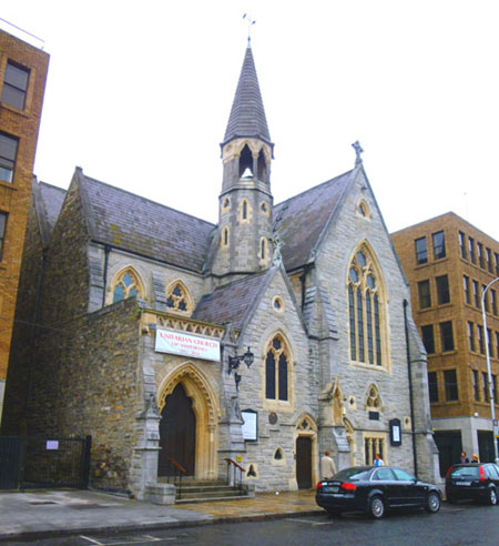
Another block south brought me to the front of St. Ann's Church. This church was built in the early 18th century following the establishment of the Anglican parish in 1707. Today, the church presents itself as ecumenical within the tradition of the Church of Ireland. The construction of the baroque style building began in 1720 to a design by Issac Wills. The current fa�ade dates to the 19th century. In 1907, St. Ann's was listed with five other churches as Dublin's only church buildings surviving from the 18th century.
The original fa�ade was never completed above the first floor. In 1868, a competition was held for a new fa�ade, and the commission went to the designers of many buildings at Oxford University, hence the neo-Romanesque front. Described by one travel guide as "amazingly ornate," the fa�ade as it exists today lacks some elements of Deane's original conception, most significantly the tallest tower, and many think that the original design was much more integrated and pleasing.
|
Continuing down the street I came by the Mansion House (seen at right). The Mansion House has been the official residence of the Lord Mayor of Dublin since 1715. The Mansion House was built in 1710 by the merchant and property developer Joshua Dawson, for whom Dawson Street is named. Dublin purchased the house in 1715 as the Mayor's residence.
In the 1930s, plans were put forth to demolish the building (and a sizeable area around it) to enable the building of a new Dublin City Hall, but the government buildings I'd seen over near Merrion Square Park was built instead. The distinctive metal portico over the main door was erected for the visit of Queen Victoria in 1900; other notables who have visited the building include Prince Rainier III and Princess Grace of Monaco and Pope John Paul II.
Just north of the Mansion House on Dawson street is one of Dublin's most exclusive restaurants- Fire. (At first glance it reminded me of the futuristic fire departments in the movie Fahrenheit 451.
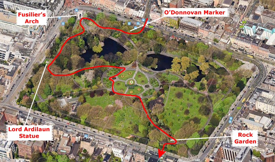
I completed this section of my walk when I got to the foot of Dawson Street and crossed the road that surrounds St. Stephen's Green, entering the park from the north side.
Walking Through St. Stephen's Green
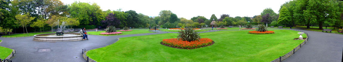 The Central Portion of St. Stephen's Green |
The park is rectangular, surrounded by streets that once formed major traffic arteries through Dublin city center, although traffic management changes implemented in 2004 during the course of the work on the light rail line have greatly reduced the volume of traffic. These four streets are named for the park, with the addition of compass points.
|
In 1663 St Stephen's Green was a marshy common on the edge of Dublin, used for grazing. The city bought the land that year, enclosed an area of it with a wall, and sold off the plots around it for building. By the end of the 1700s, stately Georgian homes surrounded the park. Relatively little survives from this era; today's buildings are replicas. In 1814 control of St Stephen's Green park passed to Commissioners for the local householders, who redesigned its layout and replaced the walls with railings. A suggestion by Queen Victoria to rename the park after the late Prince Albert was rejected by Dublin (to the Queen's chagrin). Even the one-percent don't always get what they want.
In 1887, local-resident-only access was removed at the initiative of Sir A.E. Guinness, a member of the Guinness brewing family. He later paid for the laying out of the Green in approximately its current form, which took place in 1880, and gave it to the Corporation, as representatives of the people. By way of thanks the city commissioned a statue of him, situated on the west side of the park.
The park was occupied, temporarily, by the Irish Citizen's Army during the Easter Rising of 1916, but the British Army took positions on top of surrounding buildings, forcing their eventual withdrawal to the Royal College of Surgeons on the west side of the Green. During the Rising, fire was temporarily halted to allow the park's groundsman to feed the local ducks.
|
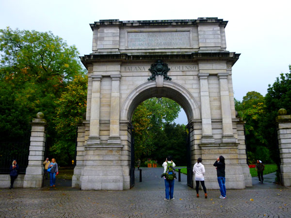
Fusiliers' Arch, seen at left, forms part of the Grafton Street entrance to the park; it was dedicated to the officers, non-commissioned officers and enlisted men of the Royal Dublin Fusiliers who fought and died in the Second Boer War (1899-1902). Funded by public subscription, the arch was designed by John Howard Pentland and built by Henry Laverty and Sons. The dimensions of the structure are said to be modelled on the Arch of Titus in Rome; it is 75 ft wide and 33 ft high. The internal dimensions of the arch are 18 by 12 ft. The main structure of the arch is granite, with the inscriptions carried out in limestone, and a bronze adornment on the front of the arch.
The arch lists the principal battles and locations at which the fusiliers fought: Hart's Hill, Ladysmith, Talana, Colenso, Tugela Heights, and Laing's Nek. The names of 212 dead are inscribed on the underside of the arch. The construction of the arch coincided with a time of political and social change in Ireland, and the colonial and imperial background to the dedication were anthema to a burgeoning nationalist movement - who labelled the structure "Traitor's Gate". Though damaged in a cross-fire between the Irish Citizens Army and British troops during the 1916 Easter Rising, the arch remains "one of the few colonialist monuments in Dublin not blown up" in Ireland's post-independence history.
The landscaping of the park has undergone three major changes since its inception. Its first major change occurred in 1670: two rows of lime trees were planted around the perimeter, functioning as its first enclosure. At this time, the park was only accessible to the wealthy residents who owned plots around it.
|
In St. Stephen's Green |
 |
In 1815 the park was redesigned by the Dublin city surveyor Arthur Neville. In his redesign, he added winding pathways and iron fences. At this time, the park was still closed to the public. Finally, during the 1860s, as part of the move to make the park public, the city engineer proposed a new design to make the park as walkable and as functionally practical as possible. This included creating four gates at each corner of the park that would be linked by pathways. This plan was finally put into operation by Sir Guinness (Lord Ardilaun). He also played a significant role in the planning and importing of the exotic trees and plants what would be installed in the park.
I wandered southward through the park, exiting near the southeast corner by the St. Stephen's Green Rock Garden and into the next area of my walk -the Iveagh Gardens district.
The Iveagh Gardens District
|
At right I've put the aerial view covering this section of my Dublin exploration in a scrollable window, so you can get a physical perspective and follow along with me.
The first building that I passed turned out to be the Newman University Church. Its origins date back to 1856, when Englishman John Henry Newman founded the church for the Catholic University of Ireland. In 1974 it was established as a parish church. Had I known at the time that it was one of the longest, thinnest churches I'd ever seen, sandwiched as it is between two older structures, I would definitely have gone in. If I had done so, I would have taken my own photograph of the interior of the church.
|
In 2005, University College Dublin, successor to the Catholic University, launched the International Centre for Newman Studies- an academic center established to facilitate study and scholarly research into the life, times and work of John Henry Newman- in Newman House. There are other offices in the house, and it is also a unique event venue.
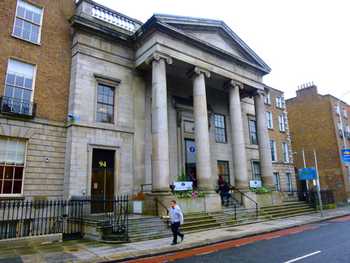
Just down the street is the Department of Equality and Justice, shown at left. This office of the Government of Ireland is led by the Minister for Justice and Equality who is assisted by one Minister of State. The Department's mission is to maintain and enhance community security and to promote a fairer society in Ireland.
Continuing down to Harcourt and then turning left, I passed a number of offices and businesses in old Georgian buildings and then found a short, dead-end street at the end of which I could see an entrance to Iveagh Gardens.
|
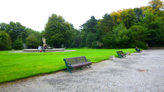
During the early 19th century the gardens were opened to the public and were called the Coburg Gardens, after the royal family of Saxe-Coburg. By 1860 they had fallen into disrepair and were restored by Guinness. They were designed to be a synthesis of the 'French Formal' and the 'English Landscape' styles. Guinness's son, Edward, the first Earl of Iveagh, gave the gardens to the newly chartered University College Dublin in 1908 (perhaps in part because his brother, Lord Ardilaun, gave St. Stephen's Green to the city in 1880); in gratitude, the gardens were renamed to Iveagh Gardens.
Walking through Iveagh Gardens I found myself again wishing that it had been a nice day. While the park was certainly pleasant enough and interesting, what with its interesting water features, its open lawns and fountains, and even a rose garden in the southeast corner (take a look at a couple of the roses here and here), it would have been much, much nicer to have been here in good weather, with a blue sky to offset the intense green all around me. Sadly, though, I had to deal with the day I had. I took a few additional pictures here in Iveagh Gardens that might be of interest to you, and you can use the clickable thumbnails below to have a look at them:
 |
Leaving Iveagh Gardens, I made my way back to Harcourt Street, coming out just by the old (opened in 1859) Harcourt Station- a former railway terminus for the line from Dublin to the town of Bray in County Wicklow.
|
|
Just past the corner of St. Stephen's Green South and St. Stephen's Green West, I came to the St. Stephen's Green Unitarian Church.
|
In 1857 a site was purchased on the west side of St Stephen�s Green, and in 1861 a design for the new church was approved. The architect was William Henry Lynn- described by one architectural journal as �one of the best architects of the Gothic Revival� in Ireland. His published obituary in 1915 said, in part: "The Unitarian Church in St Stephen's Green, a delightful building of Gothic style, has been justly described as the best example extant of a modern Gothic church on a narrow street frontage, the treatment being quite original and altogether admirable". The new church opened for public worship in 1863; four years later Dublin�s other Unitarian congregation merged with St Stephen�s Green to form one church.
The site for the church was 60 feet wide. None of the internal corners of the building are at right angles to each other as the existing houses on either side were at an angle to the street. The top of the spire is 97 feet from the street, with the main body of the church being 58 feet long by 46 feet wide. The internal design is focused on the pulpit, so that everyone in the St Stephen's Green church can hear and see the preacher, emphasising the importance of the spoken word to the Unitarian congregation.
This church was the end point of my tour through the Iveagh Gardens district. My next objective will be St. Patrick's Cathedral, but there are some interesting sights along the way.
The Whitefriar Street Church/Walking to St. Patrick's
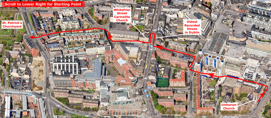 |
From the Unitarian Church, I walked half a block north to the first street west. Although I was following a tourist map, I could see the spire of St. Patrick's already, so I knew which way to go. Both of the marked locations on the tourist map were at the intersection of York and Aungier Streets. On the way along York, I saw a sign that I had to photograph, but it will only have meaning for fans of Atlas Shrugged by Ayn Rand.
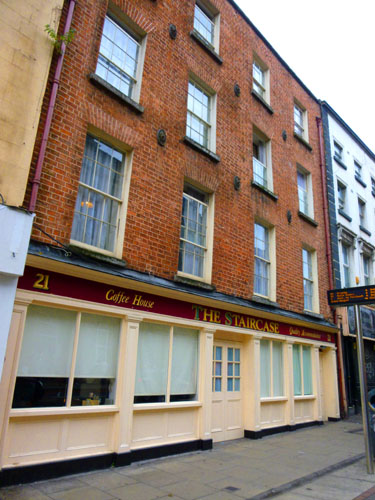
|
By the 1990s, its once bright facade had been rendered very grim, painted and painted again. But this facade concealed two extraordinary secrets. The first, of course, was the age of the building. But the secon was the existence, still, of the original 1680s freestanding handcarved staircase that soard up through the center of the building.
Having survived centuries of modification and intense multiple-occupancy use. The building was due for demolition in 1996 when the Dublin Trust, and organization that rescues historic properties, bought it from the Dublin Corporation (basically, the City). The Trust then takes such dilapidated buildings and, using much donated material and labor as well as money donated to it for the purpose, renovates and then sells the properties- usually at a profit.
The front elevation was cleaned of its many coats of paint, revealing a delicate tuck pointed facade c. 1800. There was also one surviving sash window from that same time. At the back of the property, an early eighteenth century window with thick glazing bars was discovered, which was used as a model for the restoration of the windows on the rear facade. An elegant traditional shop front was also installed at ground floor level. The subsquent planning permission allowed for a fourteen bedroom guest house with restaurant at ground floor level, known as The Staircase, although the building has since been put to other uses. The building holds a particular city-granted status that gives it certain advantages but also mandates continued public access.
The other point of interest marked on my tourist map was right across the street.
|
The church is on the site of a pre-Reformation Carmelite priory built in 1539. The current structure dates from 1825 and was designed by George Papworth, who also designed St. Mary's Pro-Cathedral in Dublin. It was extended and enlarged in 1856 and 1868.
The church also contains relics of St. Albert, a Sicilian who died in 1306. On his feast day (August 7), a relic of the saint is dipped into the water of St. Albert's Well and is said to grant healing of body and mind those who use the water. The church also contains a life‑size oak figure of Our Lady of Dublin.
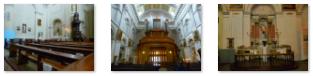
At the church entrance, the two golden statues (of Mary and, I believe, Jesus) were very beautiful, and the shrine of the crucifixion was nothing short of amazing.
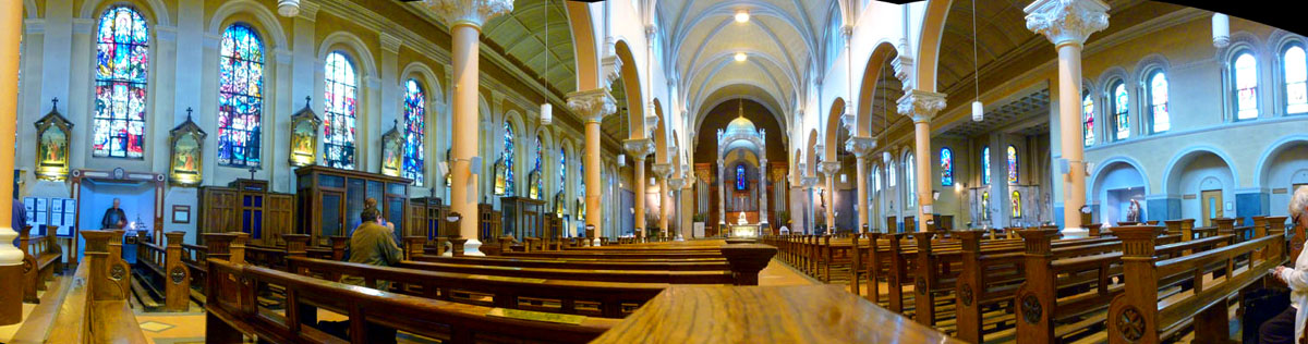
The chapel itself was also quite beautiful. In order to get a good picture of the chapel interior, I sat in a pew at the rear of the nave, set my camera on the flat top of the pew post on the aisle, and took pictures. They turned out rather well.
In fact, since I had a stable base for the camera, I took four more pictures, two each capturing the left and right sides of the church interior, with the middle pictures overlapping. This allowed me to stitch the four pictures together into what I think is a beautiful panoramic view of the inside of this church:
 |
I went back outside to continue my walk west on York Street. Right at the southwest corner of York and Aungier was an interesting little hotel. As I continued down York towards St. Patrick's, I passed a fenced yard that held some various kinds of contruction material, including these stone blocks. There weren't a lot of them, and nothing nearby that they seemed to belong to. I just hope no one is missing A17 from their restored stone building!
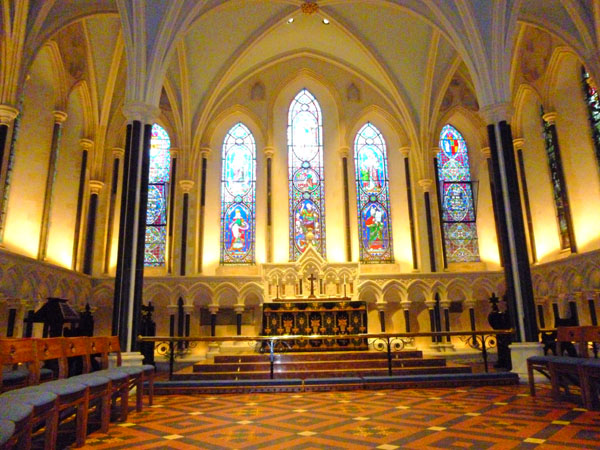
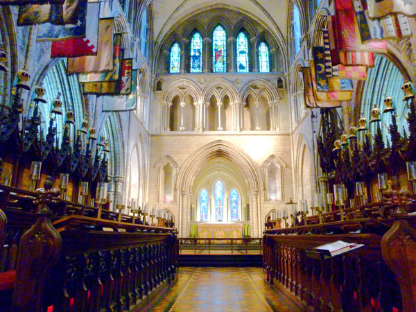
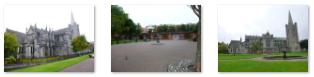
St. Patrick's Cathedral
|
The history of the church is a long one. In 1192, John Comyn, first Anglo-Norman Archbishop of Dublin, elevated one of the four Dublin Celtic parish churches, the one dedicated to St. Patrick, beside a holy well of the same name and on an island between two branches of the River Poddle, to the status of a collegiate church. From that point forward, the church expanded, fell into disrepair, was renovated and repaired over and over again.
Fast forward seven centuries. An attempt at major restoration began around 1850, but work proceeded slowly. At this time, a Celtic cross was found buried near the cathedral. It has been preserved and it is thought it may have marked the site of the former holy well. Finally, fears of imminent collapse led to a major reconstruction between 1860-1865, paid for by Benjamin Guinness. As many of the original design elements as were still serviceable were retained, but still much of the current building and decoration dates from the Victorian era- although it is in very much a Gothic style. Few records of the reconstruction were kept, so it is hard to know how much of the current building is genuinely medi�val and how much is Victorian pastiche.
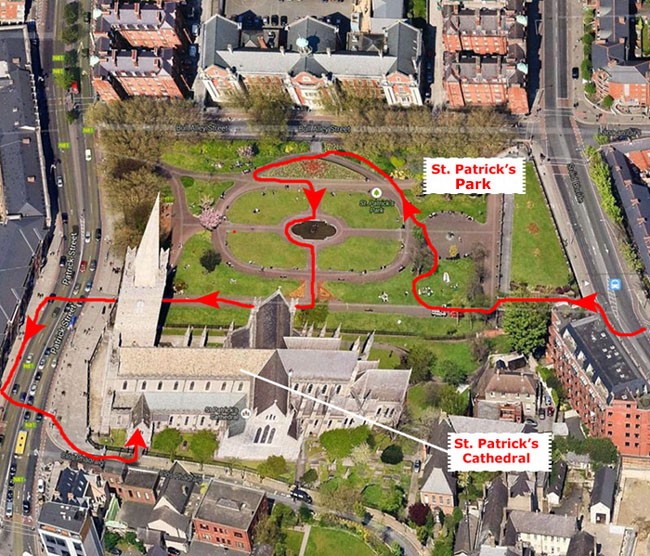
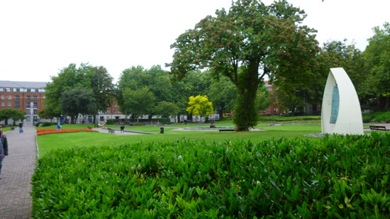
The last major change was the creation of the adjacent "St. Patrick's Park" or churchyard by Sir Benjamin's son, Edward, in 1901. Edward also donated a new set of bells to the cathedral. My route around the area first took me through the park.
|
Around to my right was a sculpture- The Liberty Bell by Vivienne Roche- which was an award-winner at Dublin's Millennium Sculpture Exhibition.
I didn't spend a great deal of time in the park, but I did go far enough towards the north side of it so that I could get the entire cathedral in a single picture, and I took those from a couple of angles. There are clickable thumbnails below for three of the pictures I took in the park:
 |
I walked to the major street to the west and crossed the street so I could get the spire in a single view; then I walked to the corner opposite the cathedral entrance. From here, I could get a really good view of the entire building, and I took a number of photographs. Just the best one will suffice, and you can see it here. I crossed back to the east side of the street and went into the cathedral. Like most churches we have been in, a small fee ($5 in this case) is asked of people who come in just to see the inside of the church; actual worshippers are never charged, but there is a small side chapel where they (and the tourists) are free to go. One might think that houses of worship should always be open to all, but then someone has to maintain the building, and I think its only logical and fair that tourists should be the ones to be hit up.
|
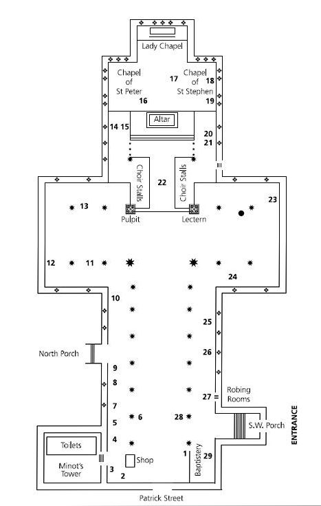
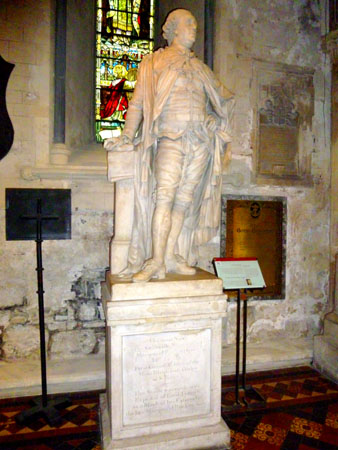
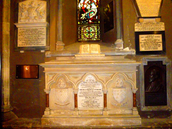
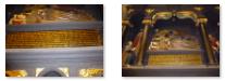
The most prominent feature at this end of the nave is the Boyle monument (1):
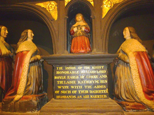 The Boyle Monument |
The Boyle monument was erected by Richard Boyle, Earl of Cork, in 1632 in memory of his second wife, Lady Katherine. Her grandfather, Robert Weston, was Dean of the Cathedral (1567-73) and Lord Chancellor of Ireland. It was first installed against the East wall of the choir, but many found its size and ornateness offensive, and it was eventually boxed and stored in 1634. It was next erected along the south wall of the chancel, but was again moved, finally, to its present position in 1863. The monument originally contained a great many carved figures, but many have been lost over the years. Below are clickable thumbnails for two additional views of this monument:
 |
Further along are two Celtic stone grave slabs bearing Christian symbols (2). You can read about these stone markers on the informational sign here. The inscription on the display base for one of these stones indicates that it was found at the supposed site of St. Patrick's Well. You can read that inscription here.
|
The north transcept has a number of items of interest, including some of the Cathedral plate made by Dublin silversmith Richard Williams in 1779. The Chapter Door (11) commemorates the amicable conclusion to the feud between the Earl of Ormond and Earl of Kildare in 1492. The Earl of Kildare cut a hole in the door and through it stretched out his arm to grasp the hand of the Earl of Ormond, his enemy, who had taken refuge in the Chapter House. By taking the initiative and reaching out in reconciliation peace was restored. The parishioners of Saint Luke's Church, Dublin gave the Huguenot Bell (12) (in memory of the coming of the Huguenots to Dublin) to Saint Patrick's Cathedral when Saint Luke's was closed for public worship in 1975. The contribution of music to the life of Saint Patrick's is celebrated in the area around the spiral staircase to the organ loft [13](13). The colours and memorials of many Irish regiments are also displayed in the North Transept.
In the north choir aisle is the tomb and effigy of Fulk de Saundford (14), Archbishop of Dublin (d. 1271). Swift wrote the Latin inscription on the black marble over the grave of the Duke of Schomberg (15), who advised William of Orange to go to Ireland in 1686, promising his support.
|
Entering the Chapel of St. Peter and going to the right around behind the main altar I entered the Lady Chapel at the far east end of the church (16). This chapel was used by the Huguenots from 1666-1816. A high-backed chair in this chapel is said to have been used by William III on 6 July 1690, when he attended service in the Cathedral after the Battle of the Boyne. There is also a statue of the Virgin and Child (17) by Friedrich Herkner. Below are clickable thumbnails for two more views of the Lady Chapel:
 |
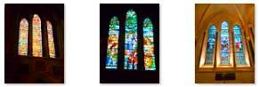
On the south side of the cathedral, opposite the Chapel of St. Peter is the Chapel of St. Stephen. Again, it is in a building corner, so it has a number of stained glass windows.
I left these three chapels via the south choir aisle. In this aisle is a stone tomb slab in memory of Archbishop Michael Tregury (18) and an Irish bas-relief effigy of an early fourteenth century church official. The aisle also contains the burial place of Dr. Elie Bouh�reau (19) (1643-1719) who was a Huguenot refugee and the first librarian of Marsh's Library. There is a large memorial to John McNeill Boyd, a Navy officer who was instrumental in saving many lives and a few vessels on February 8, 1861, when unusually ferocious storms battered the Irish coast.
|
In the south transcept is the memorial to Archbishop Narcissus Marsh (23) who founded Marsh's Library, the first public library in Ireland, in 1701. It contains Archbishop Marsh's collections of books and is still being used for its original purpose. There are two Celtic stone slabs (24) that date from the seventh and tenth centuries.
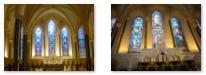
You've seen some of the cathedral's stained glass already, from the chapels at the east end, but the windows along the nave on both sides had stained glass as well. Below are clickable thumbnails for some pictures of this stained glass:
 |
|
This brings us back to the entrance at the baptistery (29). The tiles here are medieval, as is the font. The stained glass was erected in 1864. It is the work of the Casey Brothers of Dublin and was presented to the Cathedral by Timothy and Patrick Murphy, contractors, who carried out the main work of restoration for Sir Benjamin Guinness in the nineteenth century.
Coming back to the entrance from my walk around the chapel, I realized that I had taken few pictures in the center of the cathedral; of course the nave itself is quite beautiful, and the largest I had been in on this trip. So I went back to the middle of the nave to take some additional pictures.
|
|
The Floor of the Nave (Detail)
East View in the Nave
The Cathedral Ceiling Arches
West View in the Nave
The Floor of the Nave
I really enjoyed my visit to St. Patrick's Cathedral. It wouldn't be the last church I'd visit on the trip, but it was one of the most beautiful inside. I left the cathedral and walked north on Patrick Street and turned right on Bull Alley Street. From here I could get a very nice view of St. Patrick's south of me across the park. On Bull Alley I passed the front of Liberties College, an adult education institution. Now I'll be heading to the very center of Dublin to visit Dublin Castle.
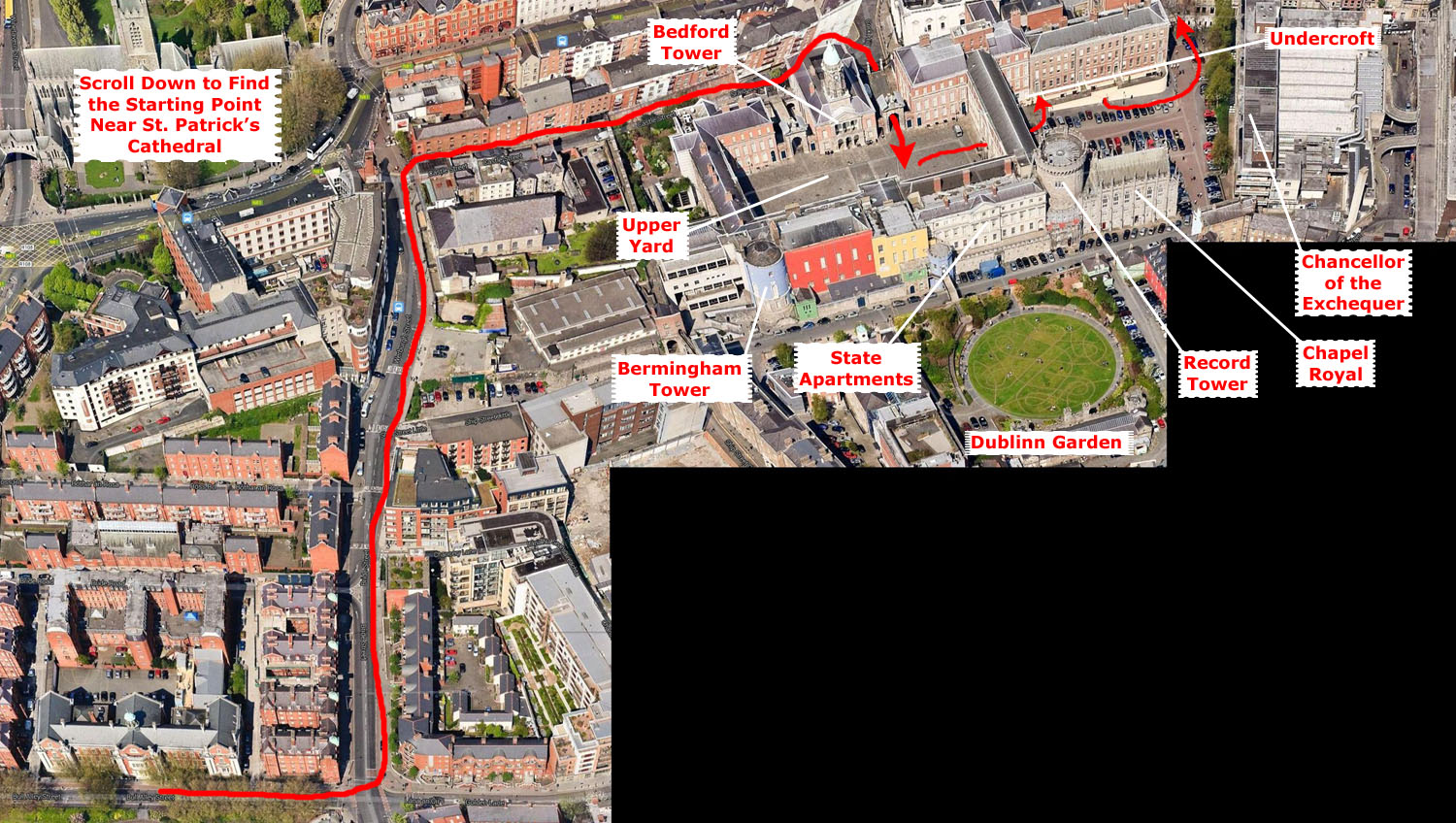
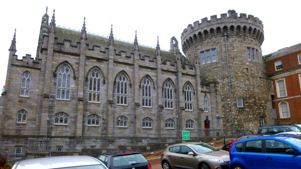
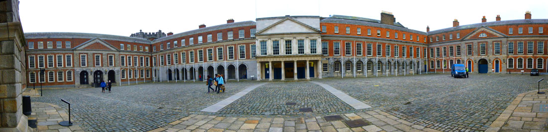
Dublin Castle
Dublin Castle was until 1922 the seat of British rule in Ireland, and is now a major Irish government complex. Most of it dates from the 18th century, though a castle has stood on the site since the days of King John, the first Lord of Ireland. The Castle served as the seat of English, then later British government of Ireland under the Lordship of Ireland (1171�1541), the Kingdom of Ireland (1541�1800), and the United Kingdom of Great Britain and Ireland (1800�1922). After the signing of the Anglo-Irish Treaty in December 1921, the complex was ceremonially handed over to the newly formed Provisional Government led by Michael Collins.
|
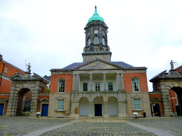
The Upper Yard
The Corke Hill gate, known as the "Gate of Justice," is the main ceremonial entrance to Dublin Castle. Atop the gate is a statue of Justice. I was listening to a tour guide while I was taking this picture, and the guide pointed out that Justice is not blindfolded, and is admiring her sword. This seemed odd, of course, but the guide pointed out that the custom of blindfolding her is a relatively recent one. The particular sculptor who did this representation did not leave records as to why he chose the form he did.
|
It was occuipied successively by the Dean of the Chapel Royal, the Second Secretary, the Master of Ceremonies and the viceroy's aide-de-camps. The balcony was used by State musicians. In 1907 the diamond Chains of Office of the Knights of St. Patrick were stolen from the ground floor library of the then Office of Arms. The mystery of what became known as the missing "Irish Crown Jewels" has never been solved. Today, the tower is used for state functions and as part of the conference center.
Adjacent to the Bedford Tower on the west is the second of the two main entry gates to the Castle, the Gate of Fortitude. The two gates were erected in 1750, and the two sculptures atop them were done by John van Nost the younger. The gate of Fortitude was opened up during the construction of the conference center, the building at the west side of the upper yard.
Dublin Castle fulfilled a number of roles through its history. Originally built as a defensive fortification for the Norman city of Dublin, it later evolved into a royal residence, resided in by the Lord Lieutenant of Ireland or Viceroy of Ireland, the representative of the monarch. The second in command in the Dublin Castle administration, the Chief Secretary for Ireland, also had his offices there. Over the years parliament and law courts met at the castle before moving to other buildings. It also served as a military garrison. Upon formation of the Free State in 1922, the Four Courts met here as their building on the quay along the Liffey River had been badly damaged during the Civil War.
Aside from the State Apartments on the south side of the yard, the other buildings on the west and east, while handsome, were not particularly old, and built for more mundane government purposes. So instead of photographing them, I've included them in a picture I made from just in front of Bedford Tower, looking across to the State Apartments, by taking four individual images and putting them together. You can see that view below:
 The Upper Castle Yard, Looking South at the State Apartments |
It was decided in 1938 that the inauguration of the first President of Ireland, Douglas Hyde, would take place in the castle, and the complex has been host to this ceremony ever since. The castle is also used for hosting official State visits as well as more informal foreign affairs engagements, state banquets, and government policy launches, as well as acting as the central base for Ireland's hosting of the European Presidency approximately every 10 years.
When the time for my tour approached, I went back across the courtyard to the entrance to the ground floor of the State Apartments. I went inside to gather with our tour guide.
The State Apartments
|
|
During the Anglo-Irish War the Castle was the nerve center of the British effort against Irish separatism, and was the scene of the Bloody Sunday massacre in 1920. When the Irish Free State came into being in 1922, Dublin Castle ceased to function as the administrative seat. It again served as temporary location for the Courts of Justice (the Four Courts), until their building on the quay, destroyed in 1922, was rebuilt. After the Courts departed, the Castle's use became ceremonial. The Castle is now a tourist attraction, a venue for arts and concert events, the location for European Council meetings and a venue for other state functions.
|
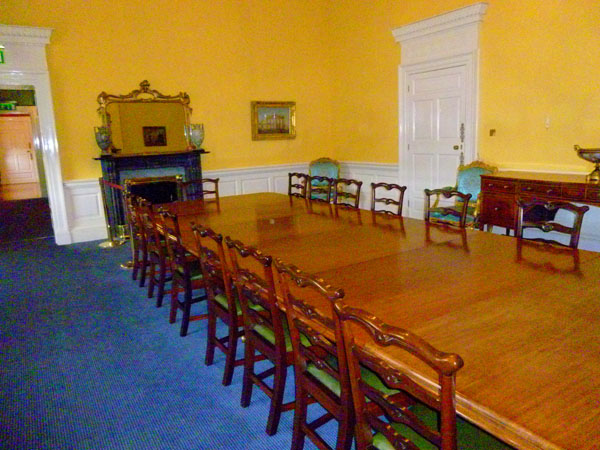
First, our guide led us eastward along the windows of the south wall of the apartments through a series of state bedrooms. These former private quarters of the Lord Lieutenant were built as five interconnecting rooms running along the back of the building, adjoining the spine corridor that separates them from the State Drawing Room.
Completely rebuilt in the 1960s following the 1941 fire, the rooms maintain the original courtly sequence and today are used as ancillary drawing and meeting rooms to the principal apartments (although British Prime Minister Margret Thatcher did spend the night in one of them during a European Council meeting in 1979). Before I followed our guide into these rooms, I hung behind to get a picture of the stairway chandelier and one of the most interesting skylights I'd yet seen.
|
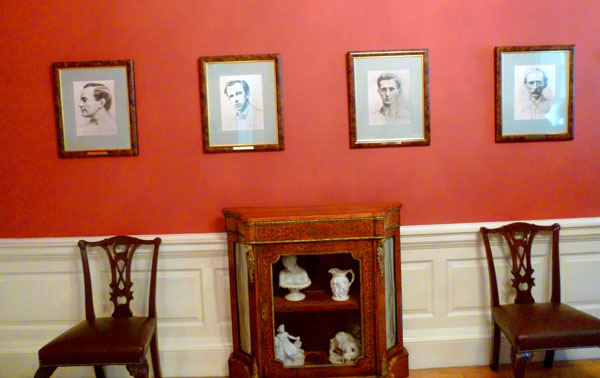
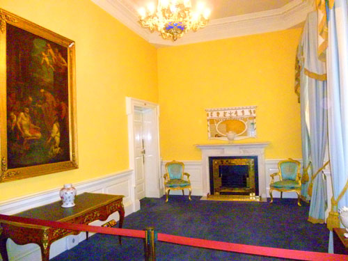
This first room is dedicated to the leaders of the 1916 Easter Rising. A wounded James Connolly was brought here after surrendering and tried by court marital while still in bed. He was condemned and executed. Portraits and plaques hang on the walls in memory of him and the other rebel leaders. This room also had a beautiful marble fireplace.
From the window in this room adjacent to the doorway into the next I could see to the south from the castle, and get a view of Dubh Linn Gardens. (The English name for the city is derived from the Irish name "Dubhlinn," meaning "black pool;" there was originally such a pool off the Poddle River where the gardens are now.
|
Standing by the windows at the south end of the room, I took two pictures, one of each half of the room and stitched them together into a mini-panorama. You can have a look at the panorama of the Granard Room at right.
The doorway on the north wall of the room leads into the State Corridor. All five of the rooms on this side of the State Apartments open onto that corridor, as well as the south side of the building.
|
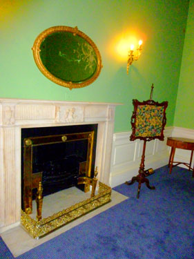
One other interesting feature of this room was a beautiful fireplace and mirror combination. While much more ornate than would be my taste, it was certainly well-made and beautifully restored.
This room, as mentioned above, had lots of windows on the south side, offering expansive views of Dubh Linn Gardens.
The next two rooms in the sequence of five along this side of the building were both colorful and tastefully decorated.
|
The Queen's Bedroom has been restored to look as during Queen Victoria's official visits to Dublin in the 19th century. Interestingly, it does not have the heavy decoration of the Victorian period but rather is in harmony with the Georgian look of the other bedrooms.
Our guide next led us through one of the two doorways from the Queen's Bedroom out into the State Corridor, and we walked along this corridor back towards Battleaxe Landing. Although this is essentially a hallway, it is made visually interesting by its archways with inlaid gilded moldings and Waterford Crystal chandeliers, which also enhance several of the other rooms. I tried to capture these details in a more closeup view of the ceiling and the chandeliers, and you can have a look at this ornate decoration here.
This expressive, deeply modelled corridor was originally built in 1758; it features a marching procession of vaults and arches which were originally top-lit. Regrettably, an office storey was built over the skylights following complete reconstruction of the corridor in the 1960s as the result of differential settlement caused by the reconstruction of the adjoining Drawing Room. The corridor features exact plaster casts of the original arch detailing, and the original doorcases and fireplaces salvaged prior to rebuilding.
|
I had an obliging tour companion take a picture of me at the west end of the Drawing Room, and that is the picture you see at left. The State Drawing Room had four large chandeliers, and you can see a closeup of one of them here.
As did many of the rooms we'd been in so far, the State Drawing Room also had fireplaces- a few of them, actually, being such a big room and constructed long before central heating. I took a picture of one of these fireplaces and the mirror above it, and you can see it here.
Out the windows of the foyer of this long room were views of the Upper Yard.
I thought the State Drawing Room was very pretty, and so I stood just inside the columns delineating it from its foyer and took two pictures, hoping to stitch them together. The result turned out well:
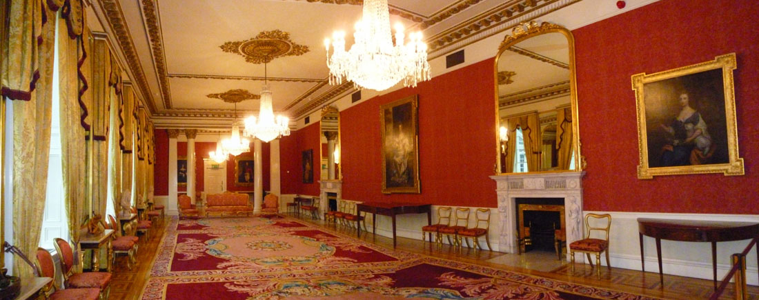 The State Drawing Room |
The next room we entered was more elaborate still but in a more baroque-influenced way. This was the Throne Room, where the King or Queen would hold formal audiences when he or she was in Ireland. Since the monarch only made occasional visits to Ireland, it was more often used by the viceroy for official ceremonies. Originally built as the Battleaxe Hall in the 1740s, it was converted to a Presence Chamber around 1790. The regal decoration dates from that time and underwent major alterations in the 1830s. Dominating the room is the throne the throne built for the visit of King George IV to Ireland in 1821; it sits under a gold color canopy. It was made for the visit of George IV in 1821 and as he was a very large man, the throne had to be very large. Out the windows of this room there were views across the Upper Yard to Bedford Tower. I made two movies in the Throne Room, and you can watch them with the players below (listening to our guide in the first one):
|
In the Throne Room of Dublin Castle |
In the Throne Room of Dublin Castle |
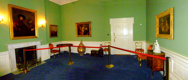
The tour continued to the west out of the Throne Room to a room that was originally a dining room, and is still used for that purpose, but which is now called The Picture Gallery.
|
The Portrait Gallery |
I made a movie in this room, and you can watch it with the player at left.
|
Our guide turned south, went through one more doorway, and we were in the last of the rooms on the tour.
|
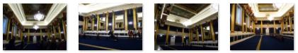
Saint Patrick's Hall |
I made a movie here in the Hall, and you can watch it with the player at right. I also took a few good pictures in the Hall, and you can use the clickable thumbnails below to have a look at them:
 |
It is one of the oldest rooms in the castle, dating from the 1740s, though its decoration largely dates from 1790, including the most significant painted ceiling in Ireland. Composed of three panels, the ceiling depicts the coronation of King George III, Saint Patrick introducing Christianity to Ireland, and King Henry II receiving the submission of the Irish Chieftains.
The part of the tour that took us through the State Apartments was done, so our guide herded us downstairs and out the doors into the Upper Yard, there to talk a bit about what you have already seen. Then we left the yard through the east archways for the tour of the Undercroft.
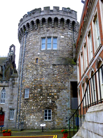
The Undercroft
|
It was the mightiest of the Norman corner towers. With 15-foot-thick walls, it was highly suited to its function as a top security jail for State prisoners.
The most famous of all the escapes from Dublin Castle took place here on January 6, 1592, when Red Hugh O'Donnell and Art and Henry O'Neill, sons of Ulster chieftains who were being held hostage on the orders of Lord Deputy Perrot, made their successful getaway through the toilet chute.
Just through the passages, I stopped to read something interesting about the offices above me. There was a particular employee who worked here from 1866 to 1878 in the Registrar of Petty Sessions Clerks, which was attached to the Chief Secretary's Office. This man's father, Abraham, had previously worked here for more than 50 years, and his son, also Abraham but who always went by a shortened form of the name, in addition to working here, was also part-time theatre critic for the Dublin Evening Mail, which was co-owned by the famous Gothic horror writer, Joseph Sheridan Le Fanu, whose writings were inspirational to him.
On promotion to Clerk of Inspection, Abraham's meticulous research of the enormous mass of accumulated official documents resulted in his first published book, The Duties of Clerks of Petty Sessions in Ireland, which he later described as being "dry as dust." His later effort, published in 1897, was considerably less so. I assume you know by now who this employee was, but if you don't, just click here.
Just before following our guide into the Undercroft, I stopped to look across the open area towards the Chapel Royal.
|
In 1943, the church became the property of the Irish Army, and the former Church of Ireland chapel became a Roman Catholic Church, under the name the Church of the Most Holy Trinity. The Stations of the Cross were then carved by the monks in Glenstall Abbey and presented to the church in 1946. Though it has not been deconsecrated, neither Masses nor Divine Services take place there any more. It has however been recently restored to its nineteenth century state and is open to the public. The crypt is sometimes used for cultural events.
Had I known that the inside was as beautiful as it reportedly is, I would have made time to go in.
Instead, I followed our guide over to the Treasury Buildings on the north side of the parking area, opposite the Chapel. These buildings, constructed in 1717, are the oldest dedicated office block in Dublin, occupied by the Comptroller and the Auditor General. The buildings were erected on the site of some stables from 1633, and raised on a platform above the sloping yard where a horse pond had been. It was underneath these buildings that the 1986 excavations were carried out.
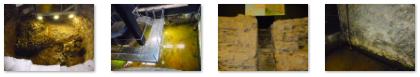
We went through a doorway in the side of the Treasury Buildings, down some stairs, and into the Undercroft. Here, features uncovered during that archaeological excavation in 1986 are on view, including part of a stone-faced Viking defensive bank, the massive remains of the 13th-century northeast corner tower of the castle (later known as the Powder Tower), a postern gate, part of the castle moat and the junction between the town wall and the castle.
|
In the Undercroft |
Also visible were the ruins the Viking defence bank, within the butt of the Norman Powder Tower. The original Tower was five stories high - the top storey being occupied by the Lord Deputy during the 16th century. You can use the clickable thumbnails below to see some of the other pictures I took here in the Undercroft:
 |
Our tour ended when the exit stairs brought us up into (surprise!) the Visitor Center Gift Shop. I didn't buy anything, but I did photograph an interesting wall poster that was an aerial view of the Dublin Castle area; you can see a picture of it here. I went back out to Lord Edward Street through an arch adjacent to the new buildings occupied by the Chancellor of the Exchequer.
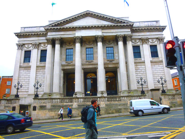
Dublin City Hall
|
To test this, I went out on the front steps of the City Hall, and took a picture looking down Capel street in front of me towards the River Liffey. Had my eyesight been good enough, I could have seen a straight line for almost a mile. (While I was out here, I also took a picture looking east down Dame street, the main thoroughfare through the southern part of the city.)
The function of the building was to provide a meeting place for Dublin's businessmen, where they could buy and sell goods and trade bills of exchange. It was also close to the then Customs House, making it convenient for overseas merchants. The cost of building the exchange was met by the Parliament of Ireland, and this is reflected by the initials "SPQH", standing for "Senatus Populus Que Hibernicus", meaning "The senate and people of Ireland" (an Irish version of SPQR).
"Maximum Occupancy" placards are quite familiar in the United States now, but were unknown Dublin until, in 1815 the metal balustrade of the exchange fell, owing to the pressure against it by a crowd, which led to the death of nine people, with many more injured. Since then, the City Hall and other buildings have put occupancy restrictions in place.
|
Today, the building has been restored to its 18th-century appearance, and Dublin City Council has won awards for the conservation of this historic building. Most Dublin City Council staff are located in the relatively new and controversial Civic Offices, built from 1979 on the site of a national monument, the Viking city foundations on Wood Quay. (I passed those a bit later on.) However, Council meetings still take place here.
Presiding over the interior is a statue of Thomas Drummond, who as undersecretary for Ireland in the 1830s initiated reform of th epolice, introduced railways to Ireland and abolished the hated system of tithes, which had brought misery to the country's farmers. A lighthouse at his feet commemorates his invention of a lamp which was a boon to shipping in fog and mist.
|
Inside the Rotunda of Dublin City Hall |
I made what I think is a good movie here inside the City Hall, and I hope you will use the player at right to watch it.
Oh, I almost forgot. The reason I stopped in to the City Hall in the first place is that it seemed as if some function was going on, and I was curious. I saw the setup in the Rotunda but as whatever was going on didn't seem to be going on at the moment, I asked the fellow sitting at the information desk in the lobby what was happening. Turns out that today is the day of the week that civil unions are performed in the city of Dublin. "Oh, you mean all these folks are getting married?" I asked him. The answer I got was a model for the way I think such things should be done here. Marriages, he said, are a private affair, and have no meaning when it comes to any public purpose, and a great many couples choose the union only, as it is the only piece of paper that matters in the courts, to employers, for pensions and taxes and so on. How very rational.
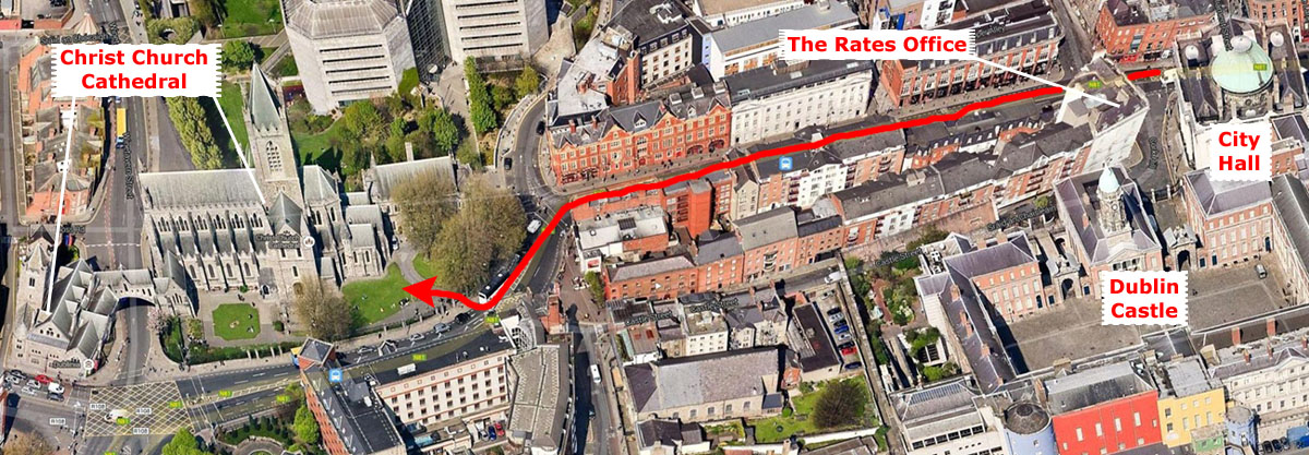
When I left City Hall, I noticed another interesting building on the other side of Parliament Street. Turned out it was the Rates Office (similar to our Tax Assessor). I continued west past this building on my way to Christ Church Cathedral.
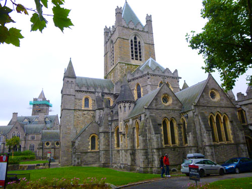
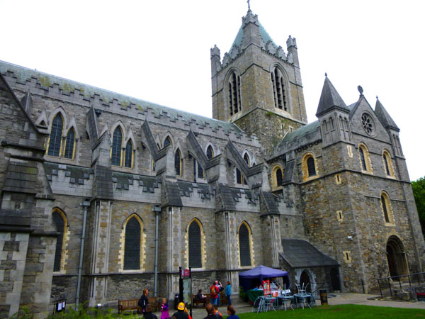
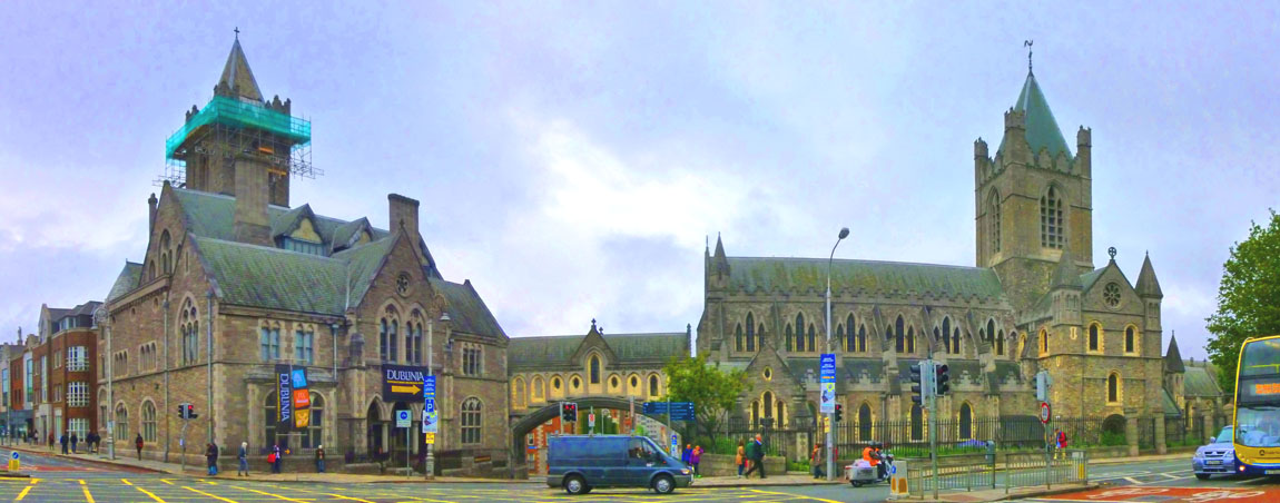
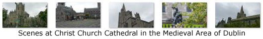
Christ Church Cathedral
 |
Christ Church Cathedral (or, more formally, The Cathedral of the Holy Trinity) is the cathedral of the United Dioceses of Dublin and Glendalough and the cathedral of the Ecclesiastical province of the United Provinces of Dublin and Cashel in the Church of Ireland. It is the elder of the capital city's two medieval cathedrals, the other being St Patrick's Cathedral.
Christ Church is officially claimed as the seat (cathedra) of both the Church of Ireland and Roman Catholic archbishops of Dublin. In practice, since the English Reformation, it has been the cathedral of only the Church of Ireland's Archbishop of Dublin. Though nominally claimed as his cathedral, the Roman Catholic Archbishop of Dublin uses St Mary's in Marlborough Street in Dublin as his pro-cathedral (acting cathedral).
|
The cathedral was founded probably sometime after 1028 when King Sitric Silkenbeard, the Hiberno-Norse king of Dublin, made a pilgrimage to Rome. This new Dublin was at that time a small island of land surrounded by the much larger Diocese of Glendalough, and was for a time answerable to Canterbury rather than to the Irish Church hierarchy. The church was built on the high ground overlooking the Viking settlement at Wood Quay and Sitric gave substantial lands for its maintenance.
The Benedictines were introduced by the second bishop, Laurence O'Toole, and in 1163, Christ Church was converted to a priory of the Reformed Augustinian Rule by him. It was subsequently headed by an Augustinian prior until re-establishment in 1541. This priory, the Priory of the Holy Trinity, became the wealthiest religious house in Ireland, holding over 10,000 acres of property in County Dublin alone.
Henry II attended the Christmas service at the cathedral in 1171; according to the cathedral guidebook this was the first time Henry received Holy Communion following the murder of Thomas Beckett by Henry's knights in Canterbury. In the 1180s, Strongbow and other Norman magnates helped to fund a complete rebuilding of Christ Church, initially a wooden building, in stone, comprising the construction of a choir, choir aisles and transepts, the crypt and chapels. Much of the nave was built in the 1230s, and further improvements made during the next 300 years.
|
The foundations of the nave, resting in peat, slipped in 1562, bringing down the south wall and the arched stone roof (the north wall, which visibly leans, survived, and largely dates back to 1230). Partial repairs were carried out but much of the debris was simply levelled and new flooring built over it. The building continued to deteriorate until, just after the turn of the nineteenth century, it was declared unsafe; limited repairs were made between 1829 and 1831.
Finally, a major renovation/rebuilding was performed from 1871 to 1878. The great 14th century choir was demolished and a new eastern end was built over the original crypt. The church got a new chapter house, tower and south nave arcade. Decorative flying buttresses were added and a baptistry was built. The adjacent Synod Hall was built and linked to the cathedral by an iconic covered footbridge. This huge project cost almost $50 million in today's terms. The Synod Hall is now home to the Dublinia exhibition about medieval Dublin.
Most of the views I had of the cathedral were taken from Lord Edward Street just south of the buildings, but I wanted to get a feel for how the cathedral looked from the River Liffey. I did not have to go far down the street underneath the walkway to get a good view that expressed how the church looked on its high ground; you can see that picture here.
I could have gone in this cathedral as well, but I still had a list of things to see and less and less daylight in which to see them, so I eschewed a visit. After all, it's not as if we hadn't already seen a great many churches on our trip (Bath, Aberdeen, Stirling, Edinburgh, Carlisle, etc.). But I did want to get a picture of the entire complex- the cathedral, synod building and bridge. To do so, I had to take two different pictures from across Lord Edward Street and stitch them together. The result is below:
 Christ Church Cathedral Complex: Synod Building, Bridge and Cathedral |
I continued down Lord Edward Street to my next objectives- the old St. Audoen's Church and the Dublin City Walls.
St. Audoen's Church and the Old City Walls
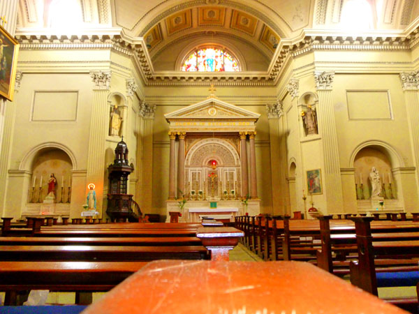
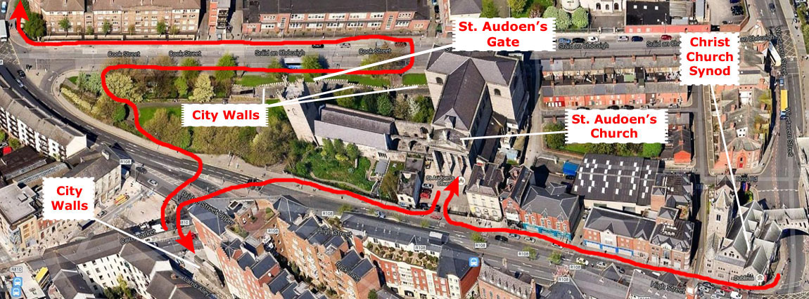 |
St. Audoen's is a Catholic church on the north side of High Street, and now home to the Polish chaplaincy in Ireland. The church was built between 1841 and 1847 to the design of Patrick Byrne who also designed nearby St. Paul's Church on Arran Quay and Church of the Immaculate Conception (Adam and Eve's) on Merchants Quay. Inside, the church was a small gem.
|
The walls are constructed of Black calp and are best appreciated from Cook Street from where their sheer bulk dominates the area and the Medieval Dublin City Walls. Because of its steeply sloping site, the church has a double level crypt to the rear. The holy water stoups on either side of the main doors are giant clam shells that were donated in 1917 by a Pacific sea captain as a gift to his brother, the parish priest at the time. Until December 2007 the church hosted a regular traditional Latin Mass. The church has experienced a resurgence of attendance due to the influx of Polish immigrants who regularly celebrate mass in the church in their native language.
Below are clickable thumbnails for three more pictures of the interior of Sts Audoen's Church:
 |
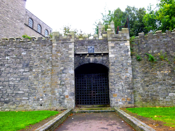
From St. Audoen's I wanted to go and see some of the remains of the city wall that once surrounded Dublin; as it turns out, the visible portions are both near the church.
|
The bigger segment of the wall is around the corner from the church down by Corn Street. To get to it, I crossed High Street and went through the St. Audoen's churchyard. The statue there is, I presume, of St. Augustine, although I can't be sure. I descended some steps to Cook Street and then turned east.
The sole surviving city gate is visible in the section of the old city wall that parallels Cook Street. Known as St Audoen�s Gate (see inset picture at right) this would have one of the main entrances into the medieval city. It was inserted through the Hiberno-Norse wall in the 13th century. Also illustrated here with the church from which it gets its name in the background. The gate leads up through a narrow alley around the sides of the church.
Other fragments of the city wall have been discovered, but these are not readily visible. For example, a building demolished in the early 1990s on Wellington Quay was found to have a very thick rear wall. It is now assumed that this was a portion of the original city wall and that the house was built up against it in the early 1700s. Excavation of the site later discovered the foundations of one of the towers on the wall. This area was the site of one of the original river crossings of the old city and gates and towers were erected for its protection.
Seeing these thousand-year-old walls was very interesting, and I was glad that I had come this far in my walk. But the afternoon was wearing on, and I didn't want to be too late getting back to the Ariel House, so I decided to begin finding my way back. I decided to take Bridge Street to the Quay and walk along it for a while.
Walking Along the Quay/The River Liffey
|
I didn't go into any of the buildings along the quay, but I did take pictures of a few of them.
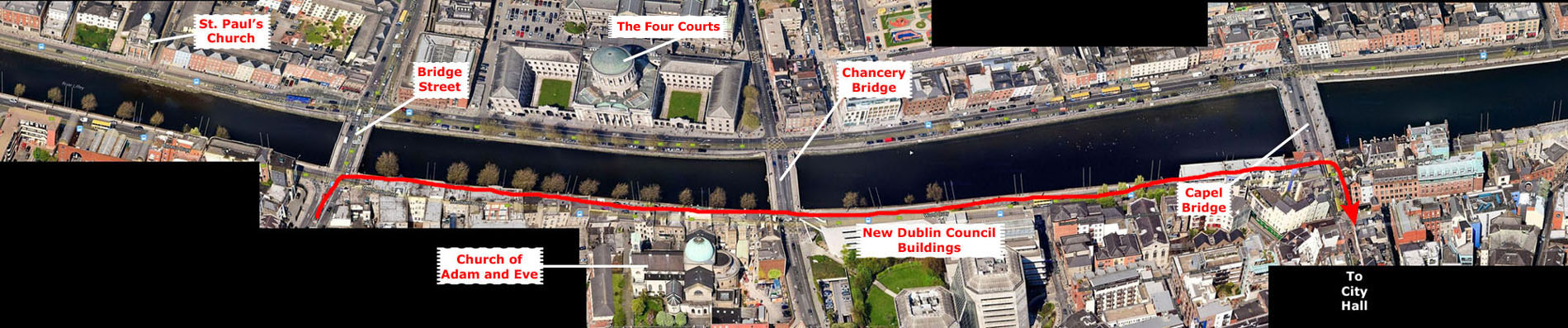
At right I have put a long strip aerial view of the section of the Quay that I covered, and if you like you can use the scroll bar to move the image to the left as I leave Bridge Street and walk eastward.
My first view, taken from the bridge at Bridge Street, looks northwest along the river, and at the center is St. Paul's Church. This church was built between 1835 and 1837 to the design of Patrick Byrne who also designed nearby St. Audoen's Catholic Church and Church of the Immaculate Conception (Adam and Eve's) on Merchants Quay.
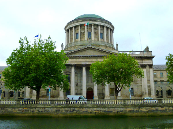
From Bridge Street, I turned to my right and began walking eastward along the Quay. Ahead of me and on the opposite bank I could see the Four Courts building.
|
Work on the building began in 1776 and was completed in 1796; the finishing touches to the arcades and wings were completed in 1802. The building originally housed the four courts of Chancery, King's Bench, Exchequer and Common Pleas, hence the name of the building. A major revision in the court system in the late nineteenth century saw these courts merged into a new High Court of Ireland, but the building has retained its historic name. This courts system remained until 1924, when the new Irish Free State introduced a new courts structure.
The Four Courts were seized during the Easter Rising in 1916. They survived the bombardment by British artillery that destroyed large parts of the city center. In 1922 they were occupied by Republican forces; when the new Provisional Government attacked the building to dislodge the rebels, a week of fighting in the city ensued and the historic building was destroyed. Most dramatically however, when the anti-Treaty contingent were surrendering, the west wing of the building was obliterated in a huge explosion, destroying the Irish Public Record Office and its priceless Irish archives. Nearly one thousand years of irreplaceable archives were destroyed in that explosion.
For a decade, the courts were based in the old viceregal apartments in Dublin Castle. In 1932, a rebuilt and remodelled Four Courts was opened. However, much of the decorative interior of the original building had been lost and, in the absence of documentary archives (some of which had been in the Public Records Office and thus lost) and funds for the project, the highly decorative interior was not replaced.
While I was standing opposite the Four Courts, I took another picture looking east along the river.
|
As I crossed Chancery Street, I looked south and I could see the walkway bridge between Christ Church Cathedral and the Synod building. From the east side of Chancery Bridge, I got some nice views looking ahead down the river, and you can use the clickable thumbnails below to have a look at them:
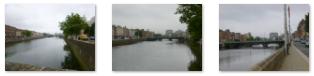 |
You may remember that earlier, when we were in City Hall, I mentioned that Dublin had built a controversial new city office down on the Quay, and I am just now walking by the City Council Office. I don't know why it's controversial; it's modern, to be sure, but there are other modern buildings down along the river.
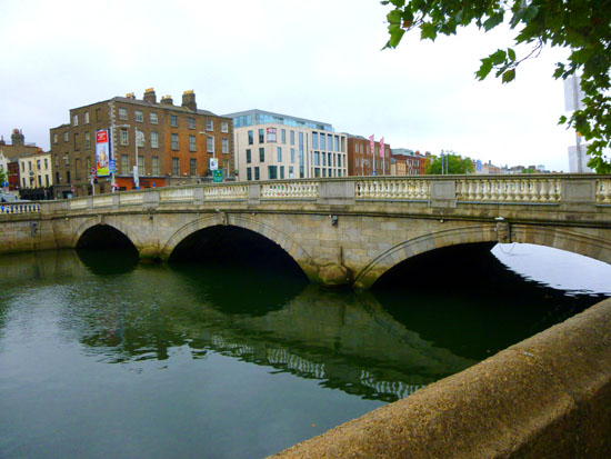
A few minutes later I came to the bridge at Capel Street where I planned to go back up to Dame Street and head further southeast towards the Ariel House. As I turned to head south towards City Hall, I took two more pictures looking upriver and down.
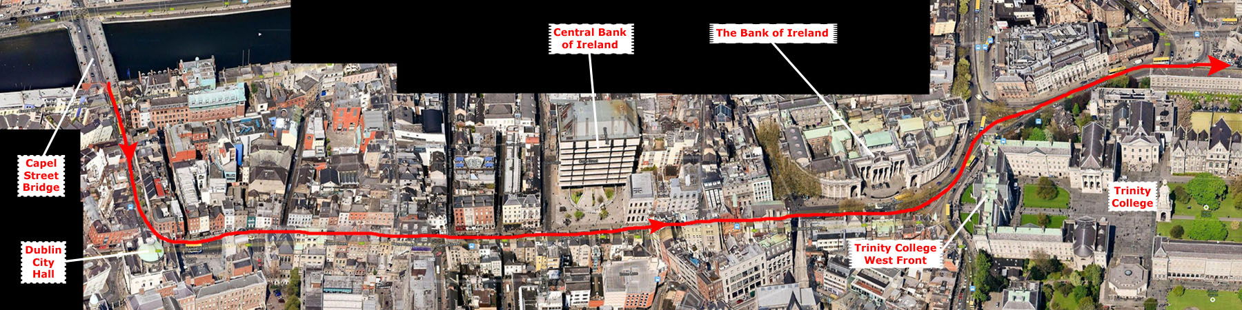
My Walk Home: Trinity College and the Financial District
|
It is College Street for a block or two before it becomes Pearse Street and heads east back towards the Ariel House.
As I said, I began by walking up Capel Street towards the Dublin City Hall. Along the way, I found some interesting street scenes to take pictures of, including the Turk's Head Chop House which, if its sign can be believed, is more than a quarter millennium old! Off on a side street was the interesting-looking Dolphin Hotel. Actually, the building, some 200 years old, is no longer a hotel, having now been converted to office space for the courts service. The building has a fine Victorian exterior with much decoration including a very sour looking dolphin over the corner entrance. I also passed the colorful Taste of Brazil, what I assume is some sort of churascurria.
|
The Action on Dame Street by City Hall |
A little ways west, I noticed an interesting triangular building across the street. I wasn't sure if "The Pen Corner" was a name for the corner itself or had something to do with what was in the building, so I went across and stuck my nose in. Turns out that The Pen Corner is a classy stationer and Dublin�s fountain pen specialist since 1927; the Pen Corner sells all types of writing instruments (apparently to those who are bored by email and want to get in touch the old-fashioned way). Elegant fountain pens (Mont Blanc, Cross, Waterman) are displayed in discreetly lit cabinets.
Across the street and a bit further down was the Central Bank of Ireland with its distinctive gold sculpture out front. (Fred got a better picture of this sculpture on the walk he took, and you can see it here.)
I continued eastward along what was now College Green Street, and a median opened up in the middle of the thoroughfare.
|
A Fountain in the Middle of College Green Street |
Looking just across the street from the fountain was the Victorian building occupied by the Ulster Bank Limited; I seemed to be walking through something of a financial center in Dublin. This seemed to be confirmed when I passed, just a few more doors down the street, the Bank of Ireland.
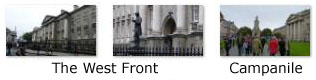
Passing the Bank of Ireland brought me around by Trinity College, where a building appropriately named "the West Front" faced me. I was too close to it for a single picture, and couldn't get back far enough, so I took two pictures and stitched them together:
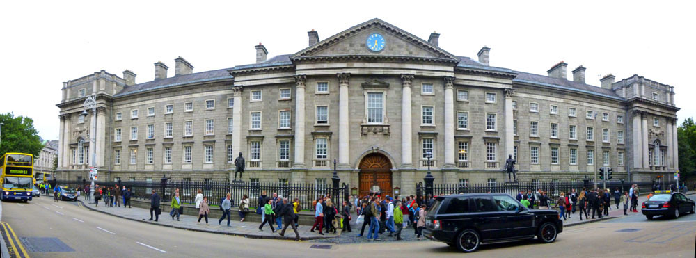 The West Front of Trinity College, Dublin |
Well, this is a milestone, for I took only one more picture on our trip to England, Scotland and Ireland, and it is time to add it here. As I came around the north side of Trinity College and headed east towards the Ariel, I took this picture looking ahead on Pearse Street. I arrived back at the Ariel Guest House about a half-hour later, completing a most interesting walk.
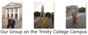
To describe the walk that everyone else took will be hard- since, of course, I wasn't along. So there won't be any maps here, nor any narrative for that matter. You might then wonder why I'm including their pictures at all. The reason is that this photo album has not for many years been just about my own pictures; when I've been on a trip with others, it's been about the sights and sounds of our destinations- no matter who took them.
But for the sights the rest of our group saw, I only have pictures- not personal reactions. So what I'll do is, under a heading for each of the major destinations the group visited, give you clickable thumbnails for the best of the pictures they took. I'll caption them where I can. So with apologies for the lack of context and supporting detail, here goes:
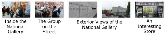
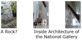
The National Gallery
|
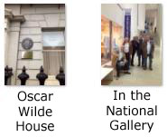
|
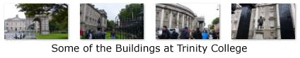
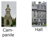
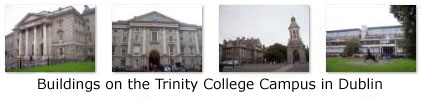
Trinity College
Originally established outside the city walls of Dublin in the buildings of the dissolved Augustinian Priory of All Hallows, Trinity College was set up in part to consolidate the rule of the Tudor monarchy in Ireland, and it was seen as the university of the Protestant Ascendancy for much of its history. Although Catholics and Dissenters had been permitted to enter as early as 1793,[6] certain restrictions on their membership of the college remained until 1873 (professorships, fellowships and scholarships were reserved for Protestants),[7] and the Catholic Church in Ireland forbade its adherents, without permission from their bishop, from attending until 1970. Women were first admitted to the college as full members in 1904.
Trinity College is now surrounded by Dublin and is located on College Green, opposite the former Irish Houses of Parliament. The college proper occupies 47 acres, with many of its buildings ranged around large quadrangles (known as 'squares') and two playing fields.
|
During the 18th century Trinity College was seen as the university of the Protestant Ascendancy. Parliament, meeting on the other side of College Green, made generous grants for building. The first building of this period was the Old Library building, begun in 1712, followed by the Printing House and the Dining Hall. During the second half of the century Parliament Square slowly emerged. The great building drive was completed in the early nineteenth century by Botany Bay, the square which derives its name in part from the herb garden it once contained (and which was succeeded by Trinity College's own Botanic Gardens). Although Catholics were admitted beginning in 1793, it was not until 1970 that the Catholic bishops withdrew their general ban on Catholic attendance.
The nineteenth century was also marked by important developments in the professional schools. The Law School was reorganised after the middle of the century. Medical teaching had been given in the College since 1711, but it was only after the establishment of the school on a firm basis by legislation in 1800, and with such teachers as Graves and Stokes, a great age of Dublin medicine began. The Engineering School was established in 1842 and was one of the first of its kind in Ireland and Britain.
|
Trinity College retains a tranquil collegiate atmosphere despite its location in the centre of a capital city (and despite its being one of the most significant tourist attractions in Dublin). This is in large part due to the compact design of the college, whose main buildings look inwards and are arranged in large quadrangles. The grounds cover 47 acres and the buildings comprise 2 million square feet of space. The main entrance to the college is on the College Green and its grounds are bounded by Nassau and Pearse street.
The western side of the college is older, featuring the iconic Campanile, as well as many fine buildings, including the Chapel and Examination Hall, Graduates Memorial Building, Museum Building, and the Rubrics, all spread across the College's five quandrangles. The Douglas Hyde Gallery, a contemporary art gallery, is located in the College as is the Samuel Beckett Theatre. The eastern side of the college is occupied by Science buildings, most of which are modern developments, arranged in three rows instead of quadrangles. The college was ranked by Forbes as the 6th most beautiful in the world.
The College also incorporates a number of buildings and facilities spread throughout the city, from the Politics and Sociology Departments located on Dame Street to teaching facilities at St James's Hospital. That hospital also hosts the Institute of Molecular Medicine and John Durkan Leukemia Institute.
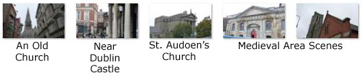
Dublin's Medieval Area
|
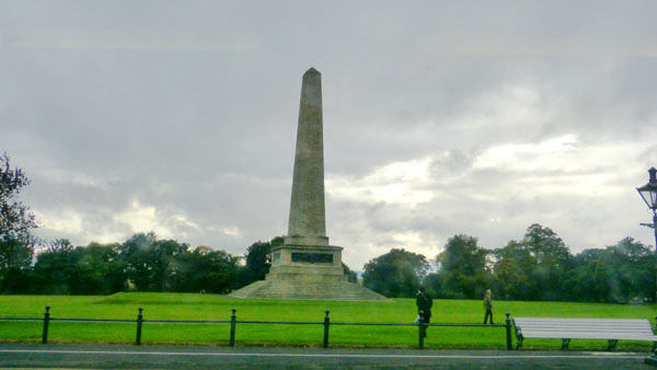
The Wellington Monument
|
The Wellington Testimonial was built to commemorate the victories of Arthur Wellesley, 1st Duke of Wellington. Wellington, an Irishman, also known as the 'Iron Duke', was born in Dublin. Originally planned to be located in Merrion Square, it was built in the Phoenix Park after opposition from the square's residents. The Testimonial was designed by the architect Sir Robert Smirke and the foundation stone was laid in 1817. However, in 1820 it ran out of construction funds and therefore remained unfinished until 1861 when it was opened to the public. There were also plans for a statue of Wellesley on horseback but the shortage of funds ruled that out.
There are four bronze plaques cast from cannons captured at Waterloo- three of which have pictorial representations of his career while the fourth has an inscription. The plaques depict Civil and Religious Liberty by John Hogan, Waterloo by Thomas Farrell and the Indian Wars by Joseph Robinson Kirk. The inscription reads:
Asia and Europe, saved by thee, proclaim
Invincible in war thy deathless name,
Now round thy brow the civic oak we twine
That every earthly glory may be thine.
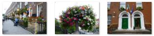
Dublin Street Scenes
|
To view the slideshow, just click on the image at left and I will open the slideshow in a new window. In the slideshow, you can use the little arrows in the lower corners of each image to move from one to the next, and the index numbers in the upper left of each image will tell you where you are in the series. When you are finished looking at the pictures, just close the popup window.
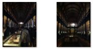
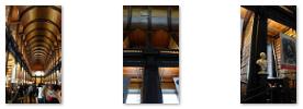
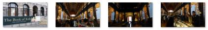
The Book of Kells
The Library comprises several buildings in college. The Old Library is Thomas Burgh�s masterpiece; a huge building, it is imposing and dominates the view of the university from Nassau Street. It was founded with the College and first endowed by James Ussher (1625�56), Archbishop of Armagh, who endowed his own valuable library, comprising several thousand printed books and manuscripts, to the College. The Book of Kells is by far the Library's most famous book and is located in the Old Library, along with the Book of Durrow, the Book of Howth and other ancient texts. Also incorporating the Long Room, the Old Library is one of Ireland's biggest tourist attractions, and holds thousands of rare, and in many cases very early, volumes.
|
The illustrations and ornamentation of the Book of Kells surpass that of other Insular Gospel books in extravagance and complexity. The decoration combines traditional Christian iconography with the ornate swirling motifs typical of Insular art. Figures of humans, animals and mythical beasts, together with Celtic knots and interlacing patterns in vibrant colors, enliven the manuscript's pages. Many of these minor decorative elements are imbued with Christian symbolism and so further emphasise the themes of the major illustrations.
The manuscript today comprises 340 folios on high-quality calf vellum, and the unprecedentedly elaborate ornamentation that covers them includes ten full-page illustrations and text pages that are vibrant with decorated initials and interlinear miniatures and mark the furthest extension of the anti-classical and energetic qualities of Insular art. The Insular majuscule script of the text itself appears to be the work of at least three different scribes. The lettering is in iron gall ink, and the colors used were derived from a wide range of substances, many of which were imports from distant lands. The manuscript takes its name from the Abbey of Kells that was its home for centuries.
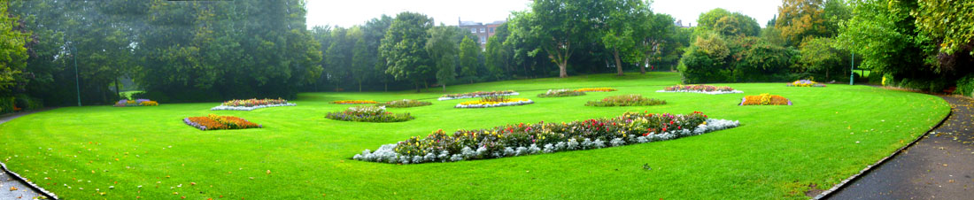
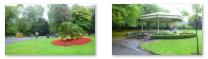
St. Stephen's Green
 |
|
September 27, 2013: Our Trip Home |
|
September 25, 2013: Walking Galway and Return to Dublin |
|
Return to the Index for Our British Isles Trip |