|
October 26 - November 14, 2022: A Trip to Fort Lauderdale |
|
August 8-23, 2022: A Trip to San Miguel Allende, Mexico |
|
Return to the Index for 2022 |
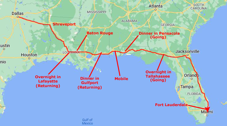
We enjoyed our trip to Mexico to stay with Greg for a couple of weeks, but now it was time for our early Fall trip to Fort Lauderdale. We are not ready to return to Ecuador yet; the purchase of the house is almost finalized, but until it is, there is not much we can do. Our visas are in the works, so at the moment it is a waiting game. So Florida it is.
As these trips to Florida have become so commonplace, I will again just divide this page by topic, pretty much regardless of when the picture was taken.
Getting to Fort Lauderdale
|
Mississippi and Alabama are an hour each, so we are heading east from Mobile about six-thirty or seven. This puts us north of Pensacola right about dinnertime about eight. After dinner, we have now developed the habit of continuing on to Tallahassee, ariving there about midnight. There is a Red Roof Inn there that is pet-friendly (allows them and doesn't charge extra for them.)
We usually get away from the hotel in Tallahassee about nine or so for the 150-mile drive to Jacksonville, which we usually reach about noon. Then we take I-295 around Jacksonville to the south, going through Orange Park. This 14-mile stretch is kind of neat, mostly because of the long bridge that crosses the St. Johns River as it opens out into a large lake southwest of the city. (It narrows as it approaches and flows around downtown Jacksonville to eventually empty into the Atlantic.)
I-295 connects up with I-95 south of the city and we simply take that south for another kind of boring 300 miles down to Fort Lauderdale. Along this streth, which Cole is quite familiar with, he sometimes comes up front to watch the traffic and help navigate. Since there are absolutely no turns to make all the way to Fort Lauderdale, this is no problem for him. We usually get to the condo around 5PM, depending on traffic in Fort Lauderdale on I-95 (which can be horrendous).
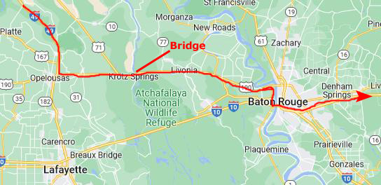
With all that said about the route, we did something just a bit different this time, something we also did on our last trip here in May. Since there is often a backup at the Mississippi River bridge on I-10, and since the car navigation system seems to know oftentimes when there is congestion and will route you around it, when we got twenty miles south of Alexandria I asked for directions to Slidell, LA, knowing that there would be only two possible routes.
|
When I asked for directions, the navigation did indeed route me to US 190. When we got near Baton Rouge, the navigation sent me south to the I-10 bridge over the Mississippi. When we got there, getting up onto the bridge was pretty smooth, and there wasn't the typical congestion on I-10 east of the bridge. So in this case, taking the advice of the navigation system seemed to work out, although I have no way of knowing if there was some sort of backup along the normal I-10 route across the Atchafalaya Basin.
Going across US 190 is shorter than going through Lafayette, but there are a few stoplights, and so maybe the time it adds if you hit some of them negates the shorter distance, but I think the time-distance tradeoff is a wash. You DO get some different scenery, though, when you go across the Atchafalaya River bridge at Krotz Springs.
Bob and Cole are young enough that they are still good travelers. Bob, for example, will come out of his carrier every hour or so and walk around the car and sit up front for a while. But then he goes right back in and curls up. Cole stays out of his own carrier more; he usually curls up behind my seat where I usually make a flat space on top of my computer and duffel for him. I like it when they come up front, and it is especially nice when they will stay in one lap or the other for a while. As the driver, I'm OK with that; I just try to ignore them and concentrate on the road.
We have been here to Florida so many times that we have pretty much photographed everything worthwhile anywhere nearby. The pictures we take now are just candid shots around the condo, at the dock or perhaps at an Art Fair or other event that occurs while we are here. So I've begun the practice of just grouping the pictures for these Florida trips by topic.
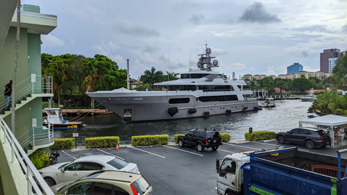
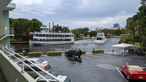
Boat Traffic on the New River (Installment 54)
|
|
From his vantage point in the condo, it's Fred who can see when an interesting boat goes by, but by the time I can get to a point where a picture is reasonable, it is often too late. But we can always hear the distinctive toot of the Jungle Queen tourist boat as well as the sounds tugs make when they are pulling a boat up or downriver.
|
Here is a movie of one of the big boats being towed upriver. |
At the Dock
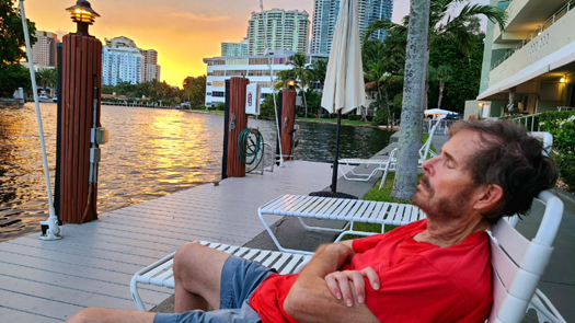 |
 |
The New Kinney Tunnel Deck Park: An Update
What follows is a section called "Background to the Project". It is a repetition of information on the Deck Park Project- a bit of the history and what the park is to look like that has appeared on any earlier "Florida Trip" pages where we took pictures of the progress of the project. If you have already read this information, please scroll down to the next subsection entitled "Project Update".
Background to the Project
|
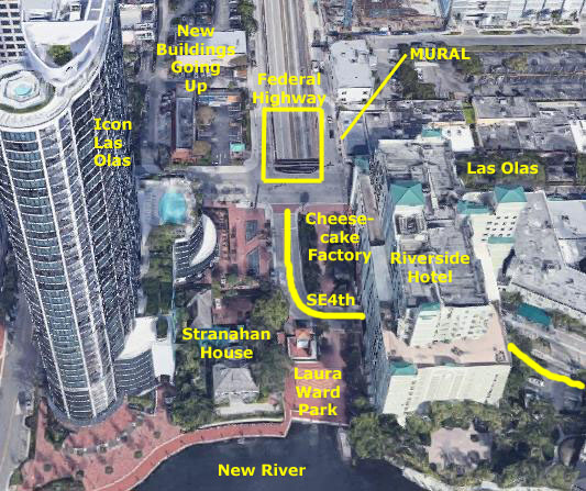
Driving south on Federal Highway from Broward Boulevard, the street descends quickly over two blocks to enter the Henry Kinney Tunnel under the New River. Just as you enter the tunnel, Las Olas is over your head. Up on Las Olas, there has always been an ugly concrete wall on the north side of the street to keep people from accidently (or on purpose) dropping anything onto the roadway below (or falling onto it). South of Las Olas, SE 4th Street curved south and east from Las Olas to go through the Riverside Hotel (actually going under part of the parking garage) and then on eastward to our condo.
Between that street and the Cheesecake Factory, there were some planters and an outside eating area for the restaurant. This is also where the commemorative brick we placed for Ty Ferel and Scott Dole is located. Between 4th Street and the New River is the Laura Ward Plaza- basically an open area with a kind of ugly ventilation shaft from the tunnel below right in the middle of it.
Ever since the Icon Las Olas went up, there has been a movement to try to do something more with this whole area. First, everyone wanted to beautify it; where Las Olas crosses over the tunnel entrance is a particular eyesore. Also, new buildings are going up just west of Federal Highway, and these, as well as the existing buildings, have a particularly unattractive view of Federal Highway's descent into the tunnel.
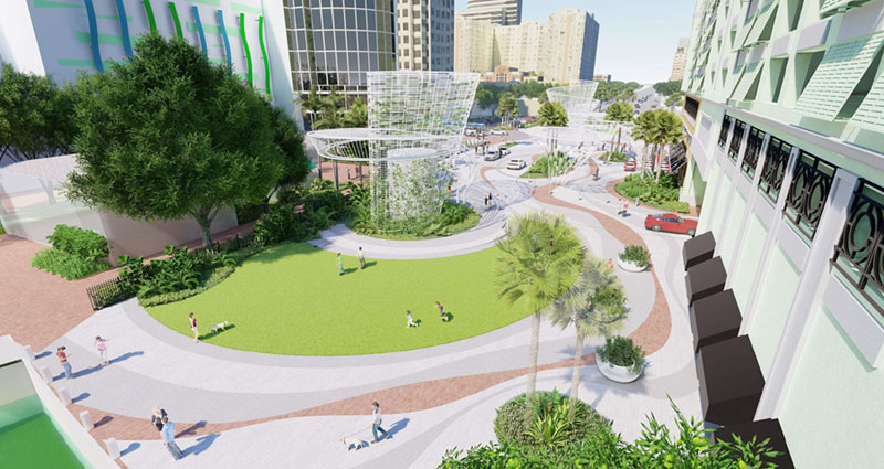
But to do anything really significant, there had to be more space, and the only way to get it would be to essentially cover over 100 feet or so of the sloping highway. But if just a flat "roof" were put over the roadway, there would not be enough clearance for many trucks that use the tunnel.
|
The greenery along the Riverside Hotel about halfway back is where the existing outside eating area for the Cheesecake Factory Restaurant is; I assume that area will return when construction is done. A bit further back, Las Olas crosses through this new park, and then there is the 100-foot section of new deck. This deck, incidentally, slopes up as it extends north, thus increasing the vertical clearance for high vehicles using the Kinney Tunnel. There appears to be more sculpture in the distance, on this new deck, perhaps also concealing another ventilation structure.
This is certainly an ambitious plan, and I will admit I am not at all sure that what we end up with will look like this, but I have to say that almost anything would be an improvement.
Project Update
|
With the upsloping deck, however, the current clearance of the tunnel itself can be maintained all the way to the end of the deck, and any truck low enough to transit the tunnel itself will be able to go under the sloping deck of the park above with no problem.
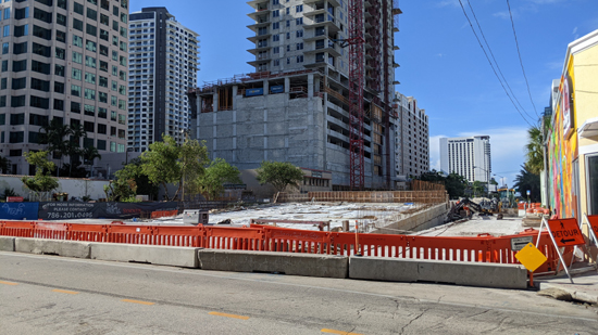
To support this deck adequately, much foundational work had to be done, and more than the first year of the project has been devoted to building a foundation for this deck. South of Las Olas, you are over the existing tunnel, so no grade improvements have had to be made there.
As a matter of fact, all they are planning to do south of Las Olas is renovate Laura Ward Park right at the river's edge, and then re-landscape the area between the Cheesecake Factory on the east and the Icon Las Olas highrise on the west. As I said last month, I am pretty sure they will restore auto access to the rear entrance of the Riverside Hotel from both directions.
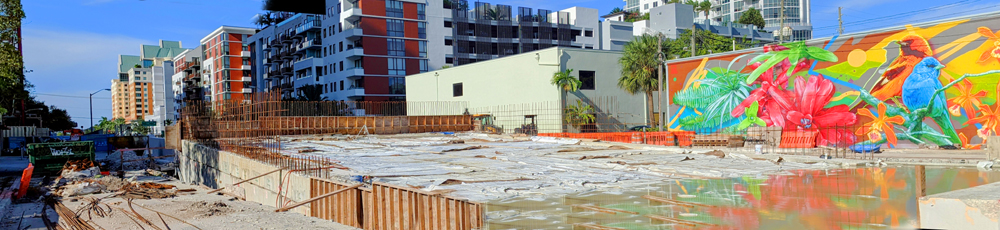
Today I also made two panoramic views. The first panorama looks at the west side of the project, and in that picture we begin at Las Olas at the left and then pan north along the west side of the project and the west side of Federal Highway going north.
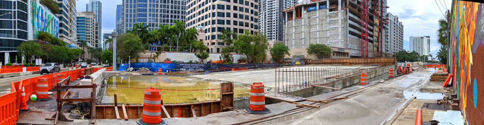 |
The second panorama below basically continues the first one and looks at the east side of the project, with the view north along Federal Highway at the left, and then pans south to take in the existing mural that is on the side of a commercial building just east of Federal and north of Las Olas. I continue to hope the mural will be retained.
 |
Miscellany
|
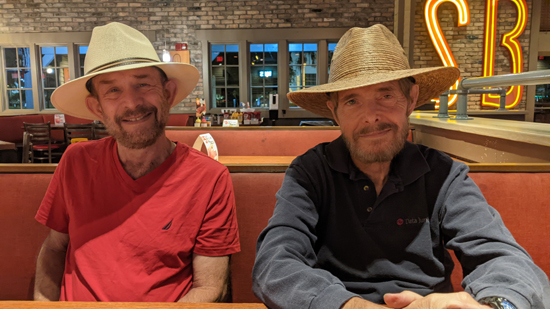
Fred and I knew we'd be telling them about our trip to Mexico, so we chose to wear our "Mexico hats". Ron and Jay thought they looked good, so after they took a picture, I asked them to take one with my phone, and the picture at left is the result.
|
|
Because it was unusual, I got my camera and went outside to record some of it. If you want to watch my short movie, it is at right.
The Trip Home
You can use the links below to continue to another photo album page.
|
October 26 - November 14, 2022: A Trip to Fort Lauderdale |
|
August 8-23, 2022: A Trip to San Miguel Allende, Mexico |
|
Return to the Index for 2022 |