|
July 20-25, 1982: A Visit to North Carolina |
|
June 12-13, 1982: A Weekend in New Salem and Springfield, Illinois |
|
Return to the Index for 1982 |
I got my next overseas assignment in July. I was to conduct a class for some McDonnell-Douglas people who were working on a long-term project in Brighton, England, at American Express. I had met a number of the people assigned to that project when I did classes for MDC for Sarson and Gane, so I was looking forward to dealing with people that I already knew.
The Trip to England
|
 |
This kind of schedule is very common for flights from the United States to Europe. Depending on where in the United States they leave from, they try to time the flights so that arrival in the European city is early in the morning. For business travelers, they can then start a work day if they wish, or lay over a day (particularly if they have been crammed into coach) and rest up to start work a day later. Vacation travelers are less persnickety.
Hampton Court
|
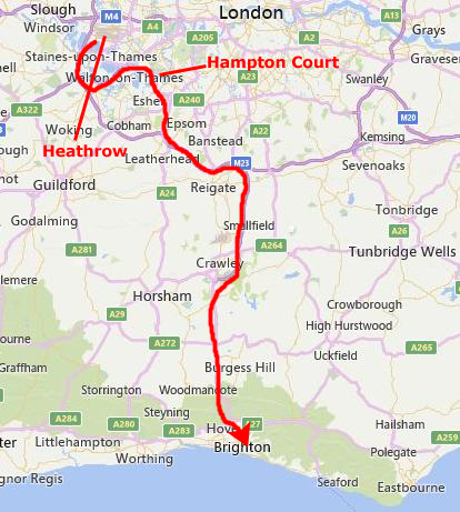
I have been to London before, and while I certainly did not exhaust the things there are to see and do there, I didn't think that six hours or so was going to be enough time to justify the train ride in and back. So we looked around for things outside London- but not too far away.
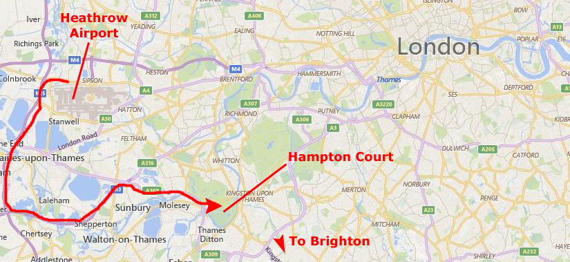
We made a short list, and the most obvious candidates were Windsor Castle, which is actually quite near Heathrow Airport out to the west (the Kings and Queens of England certainly didn't have to consider jet noise when the castle was built). The other choice was Hampton Court, a bit south and east of Heathrow. Either would be easy to get to but I would probably not be able to do both without really pushing it. In the end, when we looked up both of them in Steve's travel guides, we found that when the Queen is in residence, tours, particularly inside each castle, are sometimes cancelled, and we learned that the Queen spends a great deal more time at Windsor than at Hampton, so we thought that Hampton would be the better choice. It was also more on the way towards Brighton, which is almost due south of London on the English Channel coast.
So I made Hampton Court my primary tourist stop of the afternoon; this was good, because even though I arrived at Heathrow fairly early, by the time I had my luggage and had hired the car, it was ten o'clock in the morning, and I wanted to be in Brighton by dinnertime (certainly before it got dark).
|
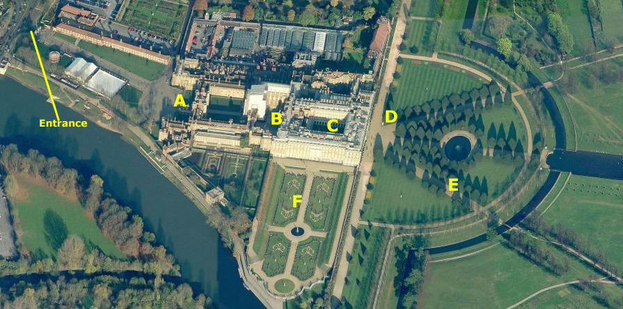
The royal palace of Hampton Court is located in the town of Hampton, Richmond upon Thames, in the southwest part of Greater London. The palace was taken for an expanded by Cardinal Thomas Wolsey in 1515. A favorite of King Henry VIII, Wolsey fell from favor in 1529, when the King seized the palace for himself (later enlarging it). Along with St James's Palace, it is one of only two surviving palaces out of the many owned by King Henry VIII.
In the following century, King William III's massive rebuilding and expansion project, which destroyed much of the Tudor palace, was intended to rival Versailles. Work ceased in 1694, leaving the palace in two distinct contrasting architectural styles, domestic Tudor and Baroque. While the palace's styles are an accident of fate, a unity exists due to the use of pink bricks and a symmetrical, if vague, balancing of successive low wings. King George II was the last monarch to reside in the palace.
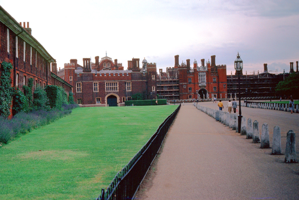
I was looking forward to seeing the castle; I did not have a chance to visit one on my previous trip to London, so this would be a first for me. The only fly in the ointment was that there were no indoor tours available today (or so I was told when I arrived). All you could do was to go into a few of the public rooms. I have no pictures of them because, like a dummy, I forgot my camera flash attachment (although I am not sure that would have been allowed anyway).
|
From 1514 through 1521, Wolsey spent lavishly to build the finest palace in England; the existing manor house was his nucleous. Today, little of Wolsey's building work remains unchanged. The first courtyard, the Base Court, was his creation, as was the second, inner gatehouse which leads to the Clock Court (where Wolsey's seal remains visible) and the clock tower containing his private rooms. The Base Court contained forty-four lodgings reserved for guests, while the second court (today, Clock Court) contained the very best rooms � the state apartments � reserved for the King and his family.
Wolsey was attempting to create a palace suitable for a cardinal, but, more than that, he wanted it to be a reflection of the power and wealth of his sovereign. Architecture critics see it as an excellent and rare example of a thirty-year era when English architecture was in a harmonious transition from domestic Tudor, strongly influenced by perpendicular Gothic, to the Italian Renaissance classical style. Wolsey was only to enjoy his palace for a few years. In 1528, knowing that his enemies and the King were engineering his downfall, he passed the palace to the King as a gift. Wolsey died two years later in 1530.
|
The King began immediately to expand the palace. His court consisted of over one thousand people, but while the King owned over sixty houses and palaces, few of these were large enough to hold the assembled court, and thus one of the first of the King's building works (in order to transform Hampton Court to a principal residence) was to quadruple the size of the kitchens, a task accomplished in 1529. King Henry did follow the design precedent set by Wolsey: perpendicular Gothic-inspired Tudor with restrained Renaissance ornament. This hybrid architecture was to remain almost unchanged until the reign of the Stuarts.
Between 1532 and 1535 Henry added the Great Hall (the last medieval great hall built for the English monarchy) and the Royal Tennis Court. The Great Hall has a carved hammer-beam roof and during Tudor times was the most important room of the palace; here, the King would dine in state seated at a table upon a raised dais. The hall took five years to complete; so impatient was the King for completion that the masons were compelled to work throughout the night by candlelight.
The gatehouse to the second, inner court was adorned in 1540 with the Hampton Court astronomical clock, an early example of a pre-Copernican astronomical clock. Still functioning, the clock shows the time of day, the phases of the moon, the month, the quarter of the year, the date, the sun and star sign, and high water at London Bridge. The latter information was of great importance to those visiting this Thames-side palace from London, as the preferred method of transport at the time was by barge, and at low water London Bridge created dangerous rapids. This gatehouse is also known today as Anne Boleyn's gate, after Henry's second wife. Work was still underway on Anne Boleyn's apartments above the gate when the King, who had become tired of her, had her executed.
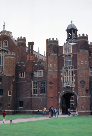 |
(Picture at left) Here is my picture of "Anne Boleyn's Gate, and you can see (although not in much detail) the astronomical clock that is mounted high above the gate entrance. This Gate is marked as "B" on the aerial view above.
(Picture at right)
|
 |
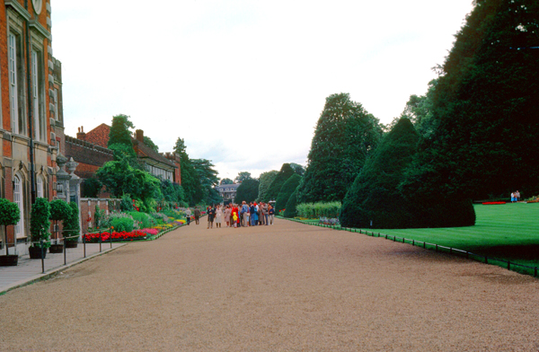
I was able to walk through some of the rooms along the way from one court to another, and if I had remembered to bring my flash, I would have taken many pictures (assuming that was allowed). I continued walking east, and came out on the East Front (marked as "D" on the aerial view) of the palace.
|
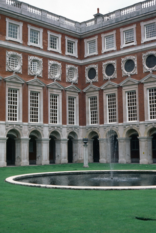
The grounds as they appear today were laid out in grand style in the late 17th century- again by Wren. To my right in the picture are the East Gardens. From a water-bounded semicircular parterre, the length of the east front, three avenues radiate in a crow's foot pattern. The central avenue, containing not a walk or a drive, but the great canal known as the Long Water, was excavated during the reign of Charles II, in 1662. The design, radical at the time, is another immediately recognizable influence from Versailles.
On the south side of the palace is the Privy Garden bounded by semi-circular wrought iron gates. This garden, originally William III's private garden, has been replanted in different styles over the years; it is currently a geometric system of paths lined by manicured hollies.
I enjoyed walking through Hampton Court a great deal, although it would have been nice to have had the time to visit Windsor Castle as well, as it is, of course, the residence of Queen Elizabeth and her family. Both are major tourist attractions, much like Mount Vernon or Sagamore Hill. These castles are actually possessions of the Royal Family and of the monarch; they, like many other castles, buildings and tracts of land, is part of the family's billion-dollar fortune. I find the relationship of modern English royalty to the State itself a curious one. If or when Queen Elizabeth or her family members cease to be the rulers of England, what will happen to all these iconic sites? But then again, I am just not used to this system of hereditary rule (although I completely understand that the English monarch today has only a fraction of the authority that the position once had. The days of "off with his head" seem to be quite gone.
|
Had Hampton Court continued as a center of State functions as it was under the Tudors, perhaps the town of Hampton would have become larger, but its population remained fairly stable at about 2500 up until the middle of the 19th century. From 1850 to 1910, the population increased to almost 10,000, with another 3,000 added in the 1920s. Writing between 1870�72 his national gazetteer, John Marius Wilson described the town as a hamlet of 3200 acres, with a total value of real property of some �25,000 (a couple of million pounds today). Since World War II, the town has grown steadily, if slowly, until now most of the land area is built out.
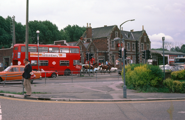
I walked around town for a bit and then returned late in the afternoon to the car park for my 90-minute trip down to Brighton.
 Here is another large English residence, south of Crawley on the way to Brighton. I did not see a name as I pulled off to take this picture. If your family can stay together for five hundred years, it is probably easy to amass enough wealth to build a family manse like this one. |
 This is the English Coast near Brighton. I made a wrong turn when I arrived, and missed the center of town where my hotel, right on the coast, was located. I am heading back to town to find it. |
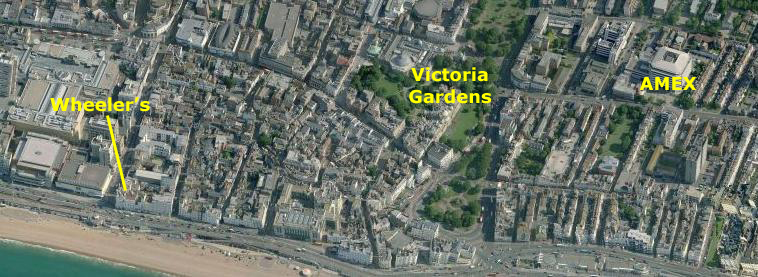
The Town of Brighton, England
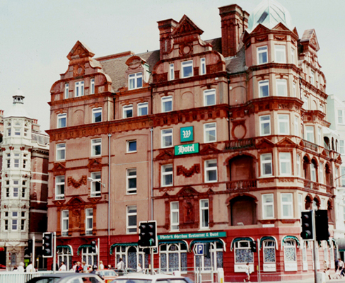
Steve usually finds me interesting places to stay overseas; when I travel domestically, I stick to Holiday Inns or other chains because I can usually get reward points or something like that. But overseas, such places can be very expensive and even though the client is paying for it, I hate to waste their money.
|
|
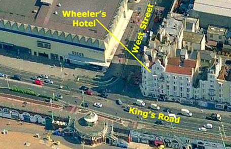
When the hotel was built in 1882, it was described as a "highly attractive, six-storey building with much terracotta decoration on both facades". It was built as the fashionable Orleans residential club, and in 1898 became the Victoria Hotel. It became the Sheridan Hotel years later, and finally Wheeler's Sheridan Restaurant and Hotel. The right side of the hotel fronts on King's Road, and right across that thorofare, on the Promenade, stands the former summer tourist information bureau, a delicate ironwork rotunda built as a promenade shelter in 1887; a shelter hall was constructed on the Lower Esplanade below at the same time. The Promenade, a two-mile boardwalk, turned out to be an ideal place for me to do my jogging.
This hotel, although it had quite a few rooms, was much different from any larger hotel I had stayed in before. It was run almost like a large home; the woman who ran it knew who all her guests were, and if she were at the desk when you returned in the afternoon, she would greet you by name. The public rooms were not as extensive as in this country, probably because there were no meeting rooms or ballrooms. There was a restaurant and a bar, but that was it. The facility was old, but well kept up, and the rooms were typical for England- quite small. I had a room with a single twin bed, a desk and chair and a bath. I was on the second floor from the top behind one of the gabled windows. There was no air-conditioning; had I been British, I might not have missed it since I wouldn't be used to it, but there were a few days where the temperature made the room somewhat uncomfortable and made it somewhat hard to sleep.
|
Unfortunately, English hotels are a bit different; two staples of American hotels were missing: soda and ice machines and airconditioning. I had to go down to the desk to get ice (and I like to use a lot of ice); they weren't used to one person using so much, and I think that the bellman didn't like traipsing back to the kitchen all the time to the one ice machine that there was. One time when I went back there myself late in the evening to get some, I met the bellman coming back. He didn't seem pleased that I was trying to save him a trip. I had to order sodas from the restaurant, or go out and by them at the little stores, but then they couldn't be kept cold very long. The hotel was nice enough, but just not the kind of place I have become used to, but then that is my fault, since the English probably find it to be a great place to stay. It is right in the middle of things, right on the boardwalk along the beach.
|
|
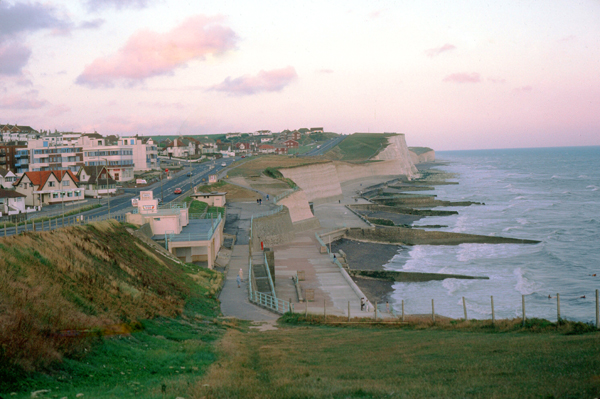
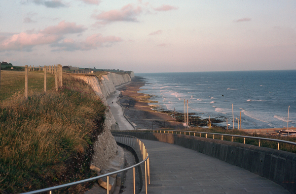
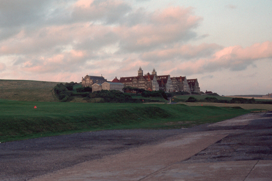
Since I had the car, I thought that I should take the opportunity to get outside of town and see some of the countryside. One of the class members who lived in Brighton told me that the best scenery was east of town along "the white cliffs of Brighton" (the same cliffs of white chalk that are so famous along the southern coast of England).
|
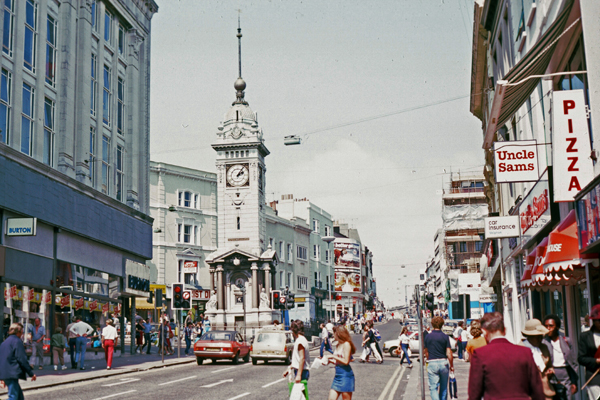
Archaeological evidence of settlement in the area of modern Brighton dates back to the Bronze Age, Roman and Anglo-Saxon periods. The ancient settlement of "Brighthelmstone" was documented in the Domesday Book (1086). The town's importance grew in the Middle Ages as the Old Town developed, but it languished in the early modern period, affected by foreign attacks, storms, a suffering economy and a declining population. Brighton began to attract more visitors following improved road transport to London and became a boarding point for boats travelling to France. The town also developed in popularity as a health resort for sea bathing as a purported cure for illnesses.
In the Georgian era, Brighton developed as a fashionable seaside resort, encouraged by the patronage of the Prince Regent, later King George IV, who spent much time in the town and constructed the Royal Pavilion in the Regency era. Brighton continued to grow as a major center of tourism following the arrival of the railways in 1841, becoming a popular destination for day-trippers from London. Many of the major attractions were built in the Victorian era, including the Grand Hotel, the West Pier, and the Brighton Palace Pier. The town continued to grow into the 20th century, expanding to incorporate more areas into the town's boundaries.
 |
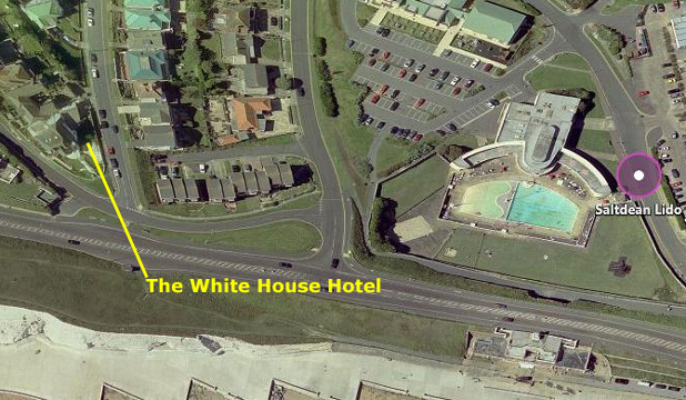 |
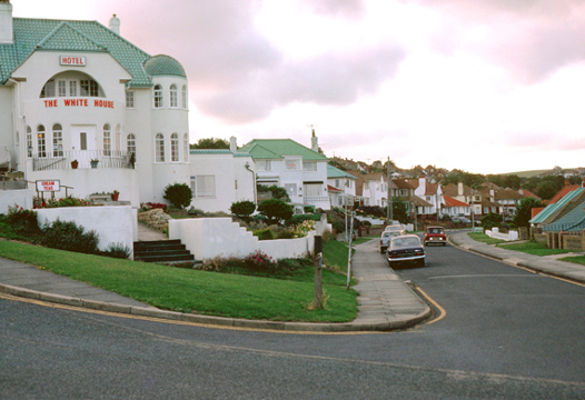
I took the picture above, left, across from the Saltdean Lido Pavilion. I thought the little hotel in the residential area was kind of neat, but this was before I learned about B&Bs. I have found an aerial view of the Saltdean Lido as well as the White House Hotel, and it is above, right.
|
Brighton's location has made it a popular destination for tourists, renowned for its diverse communities, quirky shopping areas, large cultural, music and arts scene and its large gay population, leading to its reverence as the "unofficial gay capital of the UK". Brighton attracts 4 million day visitors a year, and the vast majority of these day overnight, resulting in quite a need for both large hotels, like Wheeler's, and small hotels, like The White House. Aside from its popularity with Britons, it is the most popular seaside destination in the UK for overseas tourists. Brighton has also been called the UK's "hippest city" (even now, long passed the "hippie" era) and "the happiest place to live in the UK".
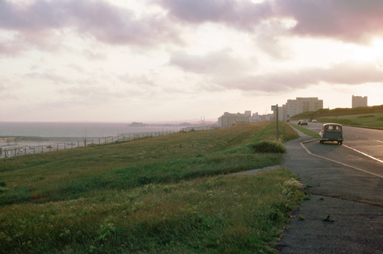
There were other little towns along the coast, and all the homes near the coast all seemed nice and neat. They also looked like they might be expensive by English standards (or our own, for that matter). They were mostly built in the style that one would expect to see in Southern California- low and white, rather than the multi-story houses one might expect on the New England coast. The roads were well-maintained and well-marked. Every so often there would be walkways down to the beach, as well as many nice restaurants.
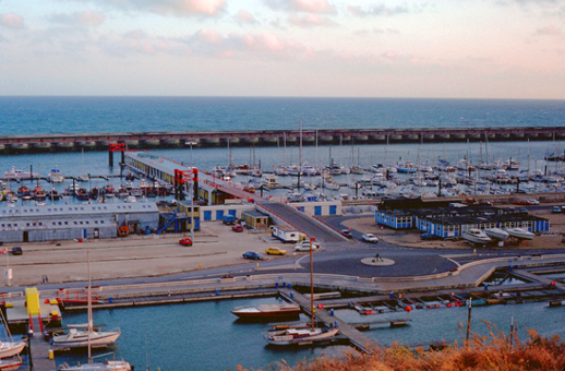
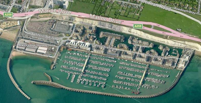
On the way back to town, I stopped to walk over to the edge of the cliffs to take a picture of an area that seemed to be enclosed by two curved breakwaters. It seemed to be some sort of commericial marine area, with a few private boats docked around. It was very much a working area. When I tried to find this place on Google Earth, just for fun, I couldn't find it. But what I did find, and confirmed by emailing one of the businesses now located there, was that the entire area had been reconstructed; it is now residential as you can see:
 |
 |
I have to say that I had a really good time during my week in Brighton. The class went well, the food was good and the scenery was excellent. What made it even better was that for two days of the week I had a local guide, and the story of how I met him is one of those personal notes that are sprinkled through this album. The note, as usual, is password protected; if you'd like to read it and don't already have the password, just email me at "website" at "rondougherty" dot "com" and I can send you one. If you are all set, then just click on this link: Meeting Neal O'Brien.
I returned to London Saturday morning and caught my return flight to Chicago on British Airways about ten in the morning. With the time difference, I was back in my condo by dinnertime.
You can use the links below to continue to another photo album page.
|
July 20-25, 1982: A Visit to North Carolina |
|
June 12-13, 1982: A Weekend in New Salem and Springfield, Illinois |
|
Return to the Index for 1982 |