|
November 22, 1986: Sailing on Lake Ray Hubbard |
|
September 20 - October 4, 1986: Two Weeks of Classes in Belgium |
|
Return to the Index for 1986 |
After returning from Europe, I had a week or two in St. Louis, and then I had a trip to San Diego to do a class for Pacific Gas and Electric. I decided that this would be a good trip for Grant to join me on. Grant was working at Senco Fastenings at the time, and they were good about letting him take a Friday off to join me in California. He stayed the weekend with me, and then flew home at the end of it, returning to Dallas and his job and leaving me to do my class.
|
Doing trips like this is one of the perks of the job I have. The standard arrangement with a client is that they pay for airfare, hotel, meals and ground transportation for the week of the class. As far as the airfare is concerned, I can bill them for the cheapest airfare, Sunday-Friday; this is usually round-trip coach. If I want to fly somewhere earlier or stay later, that is my option, and the neat thing is that if I can arrange to stay over a Saturday night, the airfare can be half or even less of what I am allowed to bill the client. So bringing Grant and staying over a Saturday night is pretty much a wash for me financially. Rental cars are a deal also; the full-week rate is usually about the same as the rate for the five weekdays. So all it costs to bring Grant along are the extra meals and any extra hotel charges.
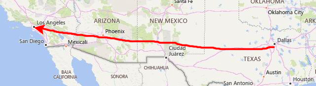
Friday, November 7: The Angeles National Forest
 |
On the map above you can see the first three stops today and their relationship to each other. First was the Angeles National Forest.
|
I am pretty familiar with Los Angeles, and so I was able to drive us directly from the airport up to Pasadena and Altadena. We stopped there for a bit of lunch before entering the National Forest at La Canada.
We are going to be driving along the Angeles Forest Highway; this road leads over the San Gabriel Mountains in Los Angeles County, California, connecting the Los Angeles Basin with the Antelope Valley and western Mojave Desert. The highway is also known as County Road N-3 or FH-59 or the Palmdale cutoff; it is about 25 miles long, but we only went far enough to see down into the desert valley northeast of the National Forest.
|
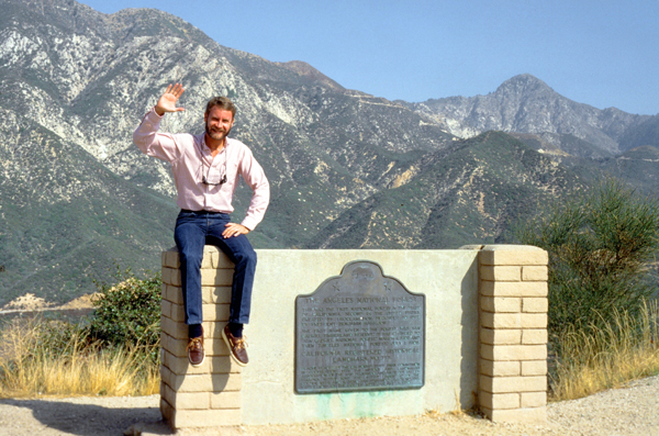
The sign reads:
THIS WAS THE FIRST NATIONAL FOREST IN
THE STATE OF CALIFORNIA, SECOND IN THE UNITED STATES,
CREATED BY PROCLAMATION DECEMBER 20, 1892
BY PRESIDENT BENJAMIN HARRISON.
THE FIRST NAME GIVEN TO THE FOREST WAS
"SAN GABRIEL TIMBERLAND RESERVE". IT WAS CHANGED TO
"SAN GABRIEL NATIONAL FOREST" MARCH 4, 1902 AND THEN
"ANGELES NATIONAL FOREST", JULY 1, 1908.
CALIFORNIA REGISTERED HISTORICAL LANDMARK NO. 717
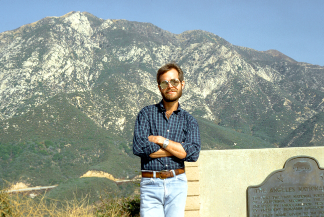
This was Grant's first time in California and also his first time anywhere near mountains as high as the ones above Los Angeles. Grant has, up until now, spent his entire life in Chicago, southern Wisconsin and northern Indiana. Moving to Texas was a big change for him, but there were no mountains like these anywhere in Texas where we have been together.
|
Many years ago, when I first came out to California to visit my college roommate, Peter, we came up to this same spot, as his family home was in Altadena, less than a couple of miles away. We didn't drive very far into the forest, but Peter wanted to show me the area- one he'd been to, of course, many times before.
Today, the weather was pretty much perfect, and I was pleased that it was good for Grant's introduction to California.
The Angeles National Forest manages numerous habitats, flora and fauna ecosystems, and watersheds. Some of the rivers with watersheds within its boundaries provide valuable non-groundwater recharge water for Southern California. The existing protected and restored native vegetation absorb and slow surface runoff of rainwater to minimize severe floods and landslides in adjacent communities. The land within the forest is diverse, both in appearance and terrain. Elevations range from 1,200 to 10,000 ft., and the Pacific Crest Trail crosses the forest.
We walked a short trail right here at the entrance to the National Forest, and then we got back in the car and continued on into the forest along the Angeles Forest Highway.
|
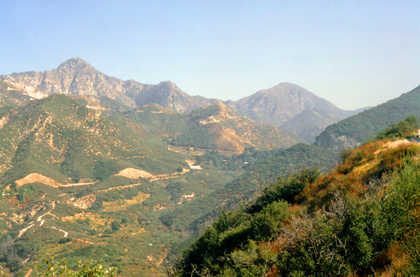
The city of Los Angeles and its suburbs have come almost to the entrance to the National Forest, so it's almost like you are just driving into a city park. But after that, when you get on Federal Land, there is no development at all, so it is a great place to get away from it all.
I thought it would also offer some good views of the city for Grant (although this hope was in vain since the usual smog clouds obscured the city pretty well). Further, Grant has never been in real mountains, unless you count the hills of Wisconsin. When Grant goes on vacation, you can be sure that it will include water and boats, so this pretty much rules out the Rockies and most of the interior West.
So I will have to work on Grant to get him to these places. But I think Grant was impressed with the Angeles Mountains, although they are not the Rockies by any means. It was a different sort of country than Grant is used to. The scenery was just spectacular all along our 20-mile drive on the highway through the National Forest.
The highway itself was a reall nice one; it passes through the Angeles National Forest, and a western section of the San Gabriel Mountains National Monument. The Angeles Forest Highway is maintained by the Los Angeles County Department of Public Works. It is used primarily for recreation, although a significant portion of its traffic comes from commuters living in the Antelope Valley.
|
Much of this National Forest is covered with dense chaparral shrub forests with oak woodlands, which changes to pine and fir-covered slopes in the higher elevations. Subsequent to the fire there was a heavy growth of "poodle dog bush" ("Eriodictyon parryi"), apparently triggered by the fire's effect on dormant seeds, that lasted for several years. The plant produces prolific lavender flowers. Unfortunately, as visitors to the Forest discovered, contact with it may cause a poison-oak-like rash.
Tree species for which the forest is important include bigcone Douglas-fir (Pseudotsuga macrocarpa), Coulter pine (Pinus coulteri), and California walnut (Juglans californica). The National Forest also contains some 29,000 acres of old growth trees, a mixture of Jeffrey pine forests and mixed conifer forests (composed primarily of Coast Douglas-fir, Ponderosa pine, white fir and lodgepole pine).
We drove into the forest for about three-quarters of an hour, before turning around and heading back the way we'd come. I might have liked to park the car and do one of the many hikes that are available in the forest, but that would have been a bit selfish. This was Grant's first trip to California, and so I thought we should see as much as we could.
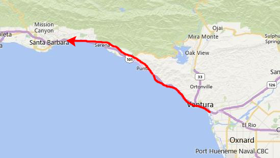
Friday, November 7: The Drive to Santa Barbara
|
Grant loves looking at boats, so we spent about two hours there wandering up and down the docks with Grant pointing out the various kinds of boats to me and chatting with some of the boat owners. There were a lot of nice boats there, but then this was the California coast.
|
I have driven almost all of this highway at one time or another, and I can confirm that there is almost noplace along it where the scenery is less than spectacular. This was Grant's first time on a highway like this one, a highway that runs along beside an ocean with mountains on the other side. He thought it as beautiful as I do, and I think he really enjoyed the ride.
We reached Santa Barbara late in the day, and got a room at a picturesque little motel right in town, but near the water. After dropping off our things, we went out for a walk, and naturally went right to the water and one of the local marinas, where Grant did his usual walkabout.
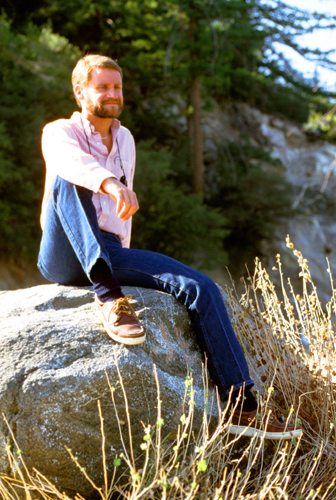
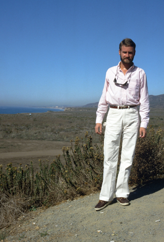
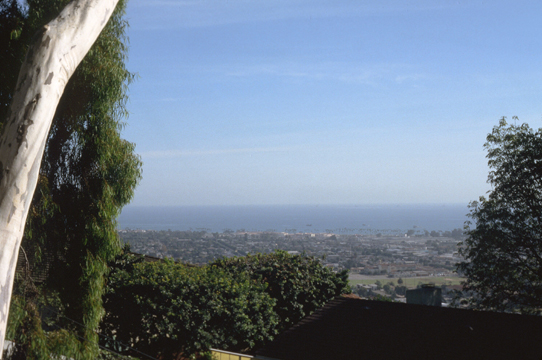
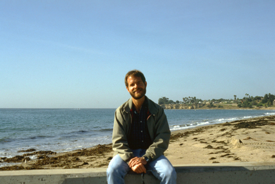 The Santa Barbara Harbor Marina was due south of the city center, right on the ocean. Adjacent to the marina was a beach, and Grant got this picture of me sitting on a breakwater. This view looks west along the shore. |
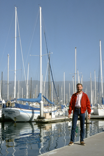
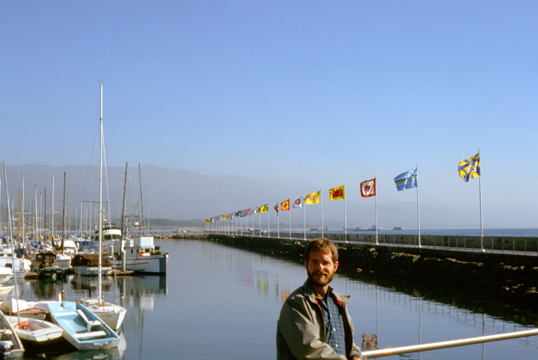 Here I am at the Santa Barbara Harbor Marina. This view looks east down the coast towards Los Angeles. |
That night, we had a nice seafood dinner, and then walked around the center of Santa Barbara for a while, went to see "Jumpin' Jack Flash" (with Whoopi Goldberg), and then went to one of the local bars for a drink and to do some sightseeing.
Saturday, November 8: Santa Barbara
|
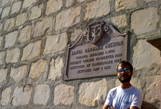
The Mission grounds occupy a rise between the Pacific Ocean and the Santa Ynez Mountains, and were consecrated by Father Ferm�n Lasu�n, who had taken over the presidency of the California mission chain upon the death of Father Presidente Jun�pero Serra. Mission Santa Barbara is the only mission to remain under the leadership of the Franciscan Friars since its founding, and today is a parish church of the Archdiocese of Los Angeles.
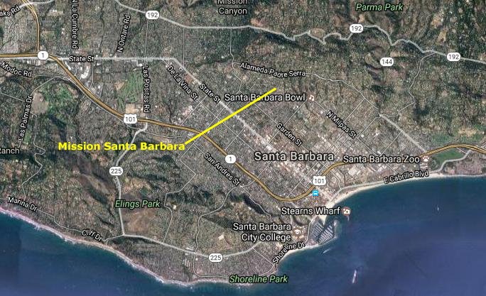
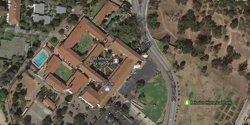
We checked out of our hotel in southeast Santa Barbara and followed our city map to find the mission itself. It is right next to a large city park, and we got there early enough that we had little problem finding a place to park.
|
One of the most significant things about this Mission as compared to many other built by the Spanish was its extensive water treatment system; that system was built by the Chumash Indians under the direction of the Franciscans, and included aqueducts, two reservoirs, a filter house, and a hydro-powered gristmill, all of which remain to this day.
The larger reservoir, which was built in 1806 when a dam was built at the end of a nearby canyon, is still, to this day, a functioning component of the water system of the City of Santa Barbara. The original fountain and lavadero are also intact near the entrance to the Mission. The dam that was constructed in that year is situated in the current Santa Barbara Botanic Garden up "Mission Canyon." The Mission's tanning vats, pottery kiln, and guard house, however, are all ruins today.
|
|
In 1818, two Argentine ships approached the coast and threatened the young town of Santa Barbara. The padres armed and trained 150 of the neophytes to prepare for attack. With their help, the Presidio soldiers confronted the Argentinians, who sailed out of the harbor without attacking.
After the Mexican Congress passed An Act for the Secularization of the Missions of California in 1833, Santa Barbara became the headquarters for all the California missions, and the Mission became the repository of some 3,000 original documents that had been scattered through those missions. The Santa Barbara Mission-Archive Library is now an independent non-profit educational and research institution that is separate from Mission Santa Barbara, and is the oldest library in the state still in the hands of its founders; it has served for more than a century as a center for historical study of the missions. Its named collections begin with Fray Junipero Serra's plans for the California missions and a large collection of early California writings, maps, and images.
|
In 1840, the California territories became their own diocese, and the new bishop, Francisco Garcia Diego y Moreno, established his cathedral here, and the Mission chapel served that purpose for a decade. There was an interregnum of four years, and then the chapel was re-established as the cathedral, which is why only Mission Santa Barbara, of all the California missions, has two matching bell towers- a particular architectural feature that was restricted to a cathedral church.
When President Abraham Lincoln restored the missions to the Catholic Church in 1865, the Mission's leader at the time, Friar Jos� Rubio, came into conflict with his bishop over the matter of whether the Mission should be under the ownership of the Franciscan order rather than the diocese. It took 60 years for the deed for the Mission to be returned to the Franciscans.
The Mission also has the oldest unbroken tradition of choral singing among the California Missions; two choirs serve the weekly liturgies. The Mission archives contain one of the richest collections of colonial Franciscan music manuscripts known today. Beginning in the mid-1800s, the original City of Santa Barbara developed between the Mission proper and the harbor, specifically near El Presidio Re�l de Santa B�rbara (the "Royal Spanish Presidio"), about a mile southeast of the Mission.
|
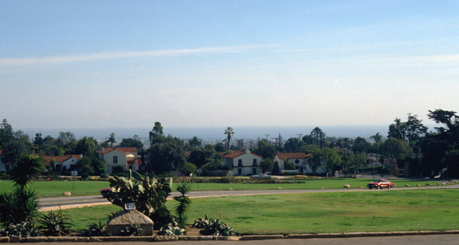
Here is a view that looks southeast across the Historical Park towards the Pacific ocean. It is evident that the Mission is on a hill, and you can see some of the residential area that surrounds the Mission.
The Mission is not actually on the highest point in the area; the mountains behind Santa Barbara are much higher, but then the land up there is not good for much of anything, certainly not living or cultivation. This is the same situation that faces most coastal California cities; the mountains that rise up quickly from the coast are not good places to build; many are subject to mudslides in heavy rains, but arid the rest of the time. Most California development is around bays, in valleys and basins, or right along the coast- such as here at Santa Barbara.
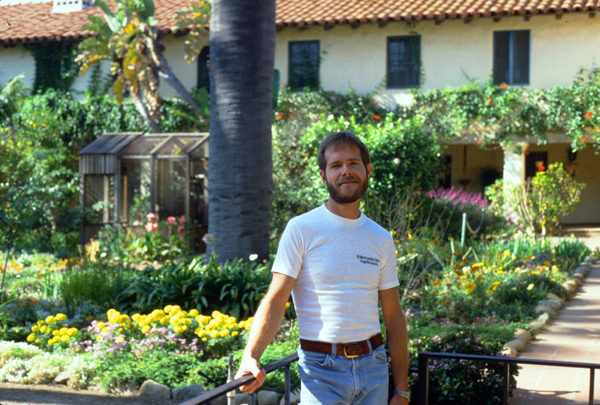
Grant and I were impressed by the area right around the Mission; it appeared as if it had become the place to live in Santa Barbara (even though the more luxurious spas and hotels are closer to the ocean or outside the city to the northwest). With the red tile roofs and lush vegetation, the area seems to be as beautiful as any area in Southern California.
|
|
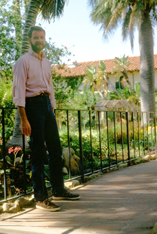
The inside of the chapel/cathedral was unlike most Catholic churches; it was very, very simple. There were decorations, of course, but all the decorative elements had the appearance of something created by the people themselves- statuary, colorful woven elements, a few golden and silver-colored cups and plates. I thought the whole result of the simple decoration was to enhance the "experience" of being in a church that was "people-sized", and where the simple faith of the parishioners was the prime focus.
Mission Santa Barbara today continues to serve the community as a parish church. In addition to its use as a place of worship, it contains a gift shop, a museum, a Franciscan Friary, and a retreat house. The Mission grounds are a primary tourist attraction in Santa Barbara. The Mission itself is owned by the Franciscan Province of Santa Barbara, and the local parish rents the church from the Franciscans.
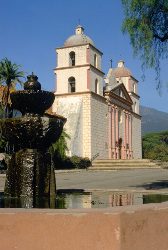
 This is the view of the Pacific from Mission Santa Barbara. We both enjoyed touring the Mission a great deal. |
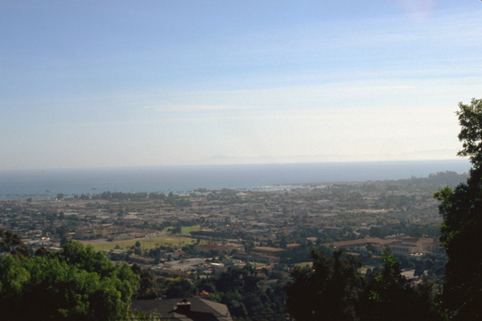 The Mission is on the crest of the first line of hills back from the ocean, so it has a pretty good view of it. Santa Barbara seems to be quite a nice place, with an excellent climate. |
We stayed in Santa Barbara and had lunch at a little restaurant downtown. After lunch, as we were driving back to Los Angeles, we found ourselves going past Magic Mountain, one of the major amusement parks in the LA area. We decided to stop and go there, since it was such a nice day. We spent an exciting afternoon riding most of the rides. That evening, we stayed at an Embassy Suites Hotel near the Los Angeles airport, and that evening I took Grant out to some of the bars on Santa Monica Boulevard.
Sunday, November 9: San Diego
|
When we left the hotel, we got onto the 405 and headed south. One odd thing I have noticed, and it only seems to occur here in Los Angeles, is that freeways are not referred to with their full names (such as "Interstate 405") or with names given them to honor some person or another (such as Dallas's "Stemmons Freeway", which is actually Interstate 35E). Instead, if they are Interstate highways, they are simply referred to as "the 5" or "the 10" (which are Calfornia's major north-south Interstate and the Interstate that come to Los Angeles from Jacksonville, Florida, respectively).
If the freeway is not an official Interstate highway, then it gets its name from the place it goes to, relative to downtown Los Angeles. So the freeway that goes down to Long Beach, is called "The Long Beach Freeway". Prior to 1983, its designation was actually California State Route 7, but it was never referred to by that name. (I might mention that the freeway received an Interstate designation in 1983, becoming Interstate 710, but no one uses that name.)
So you can end up with something like: "To get to our office from LAX, take the 405 south to the 105, head east and than take the 605 south. Take the Corona Freeway east and then the Anaheim Freeway north. Exit at West Orangethorpe, turn right and we are a mile down on the left." (which makes perfect sense to an Angeleno).
On the way down to San Diego on "the 5", Grant discovered that where irrigation doesn't happen in California, the basin is pretty much a desert. We took one particular exit south of San Clemente to take a couple of pictures.
|
|
We stopped a couple more times on the way down to San Diego at beach towns so Grant could see the sights.
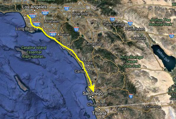
We continued down Interstate 5 towards San Diego. About twenty miles north of town, development returned, and I-5 became six lanes in each direction- a testament to the exploding population of Southern California. We passed by La Jolla, where I had joined IST in 1979, and soon came to the exit for San Diego International Airport.
|
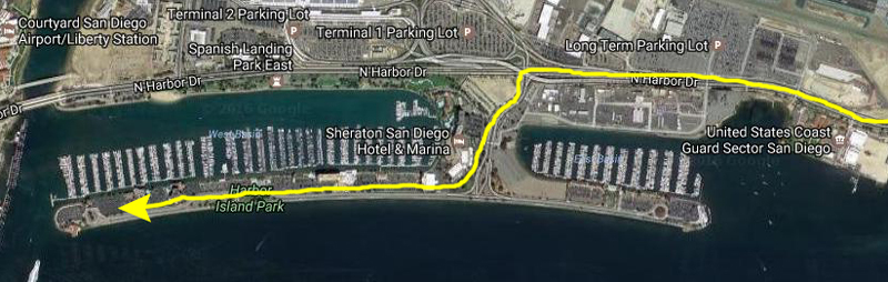 |
I turned off towards the airport and then after a few miles turned south to Harbor Island. This is where the Sheraton, where I thought I would be staying originally, but which I had changed to another hotel- the Holiday Inn in Mission Valley- when Pacific Gas and Electric, my clients for the week, moved the class from downtown San Diego out to Mission Valley (east on Interstate 8 on the north side of the city). But I'd stayed at this Sheraton before, and knew that we could park here to walk around the area.
|
|
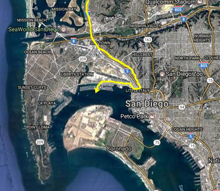
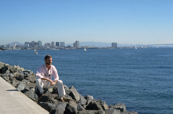
Harbor Island is artificial, built specifically for the marinas and hotels that have been constructed on it. It provides a location convenient to the airport, which itself was constructed on filled land. In the picture at left, you can see Grant sitting on the rocks on the south side of the island with downtown San Diego as a backdrop. This shot looks east across the north part of San Diego Bay.
If you'd like to relate that last picture of Grant to the aerial view of the San Diego Bay area above, look behind Grant at the right of the picture and you will see the bridge carring California route 73 from the mainland to Coronado island. We spent a pleasant couple of hours walking around the artificial island, and I even took Grant over towards Point Loma for a bit.
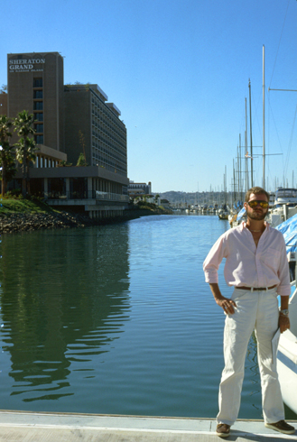
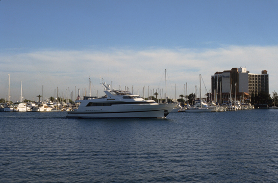 This view just tries to capture and ambiance of the San Diego harbor. The weather was wonderful, and the boats plentiful, so all in all it was a nice afternoon. |
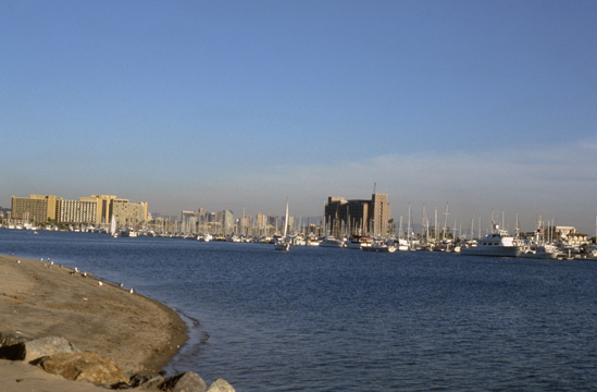 Here you can see some of the Harbor Island hotels and boats in the San Diego harbor. The Pacific Ocean is reached by taking the waterway around to the left in this picture. |
About five that afternoon, I put Grant on a plane back to Dallas, and I drove out to Mission Valley to check into the Holiday Inn for my class. Grant had a great time, and I enjoyed spending the weekend with him in a different locale than Dallas or Chicago. I look forward to taking Grant to other interesting places as my schedule permits.
I admit to a certain pride in being able to show a neophyte these places that I take for granted. I have been to so many places that relatively few people have visited nearly as many, and I think it is great when I can get Grant to see some of these places too. There are places that I go that I know Grant would not be interested in (all, oddly enough, basically landlocked), but I will be sure to try to plan more trips to places that I think Grant would like.
You can use the links below to continue to another photo album page.
|
November 22, 1986: Sailing on Lake Ray Hubbard |
|
September 20 - October 4, 1986: Two Weeks of Classes in Belgium |
|
Return to the Index for 1986 |