|
October 24, 1991: A Sea Day Aboard the Costa Riviera |
|
October 22, 1991: A Visit to St. Thomas, USVI |
|
Return to the Caribbean Cruise Index |
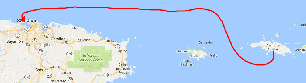
On Wednesday morning, we docked in San Juan, Puerto Rico, after spending all night cruising the 100 miles from Charlotte Amalie. Obviously, we didn't come straight here; we could have done that by midnight. The captain takes the ship back and forth through the islands all night so we can dock conveniently in San Juan early in the morning.
A Bit About Puerto Rico
 |
Originally populated by the aboriginal Taíno people, the island was claimed in 1493 by Christopher Columbus for the Kingdom of Spain, and during the four centuries of Spanish rule, the island's ethnic, cultural and physical landscapes were transformed, as the island was settled overwhelmingly by Spanish settlers. As a result, it is an overwhelmingly Catholic and markedly Hispanic territory in terms of culture and language. In 1898, following the Spanish–American War, the United States annexed the island under the terms of the Treaty of Paris.
Puerto Ricans are natural-born citizens of the United States, but the territory does not have a vote in the United States Congress, nor do its citizens vote in national elections. Congress did approve a local constitution, allowing U.S. citizens on the territory to elect a governor. For many years, the island has been dissatisfied with its territorial status, and there have been various movements and referenda calling for statehood.
Docking in San Juan, Puerto Rico
|
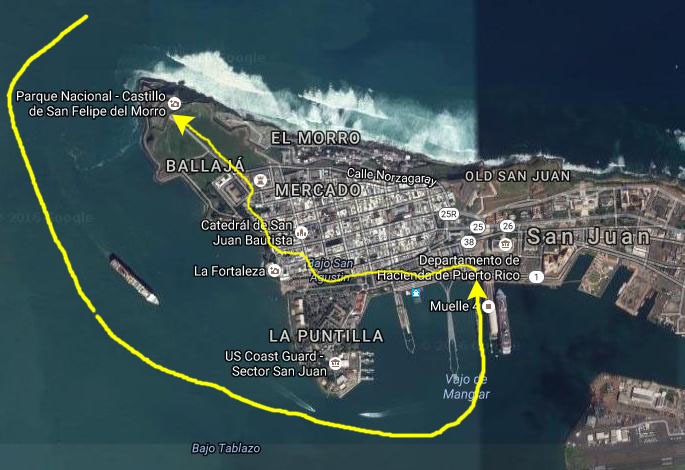
As you can see on the aerial view at left, the facilities for cruise ships at San Juan are much more extensive than at St. Thomas, perhaps because San Juan is a more frequent destination on Caribbean cruises or perhaps because ships have been calling at this port for a longer time. I suspect that it is more because San Juan is much more of a transshipment point than other islands in the archipelagos east and south.
Here, there are permanent structures for loading and unloading passengers and freight, as well as a customs house right by the dock. The cruise lines maintain embarkation and debarkation buildings on a series of piers (one of which is shown in the aerial view but which was not in place in 1991). These buildings have been changed and expanded since we were here, as they now have to accommodate ships that may be carrying five or six thousand people, rather than just the 1900+ passengers on our ship. We were able to walk down a short gangway right onto the dock when we debarked.
The port of San Juan is on the north side of the island, although the orientation of the dock is to have the ship pointed north as well. Ships come in via the channel to our west and then either turn to the north to the cruise ship docks or continue a bit further east and south to the cargo docks and facilities.
The cruise ship docks were conveniently-located to Old San Juan, the area that most tourists who are not actually staying on the island like to visit. There are shops and stores, restaurants and cafes, and two or three historic sites- all within walking distance from the ship. For this reason, we didn't book an actual shore excursion, but thought we would just walk around on our own. There are not many hotels here for the beaches are not that good. The Candado Beach area, where the main hotels are and where I stayed when I came to Puerto Rico to do a class some time ago, is further East along the North side of the island.
|
There was also another cruise ship arriving in San Juan harbor at the same time as us, and there was a bit of jockeying around so that we came in on one side of the pier and the second ship came in on the other. I should have taken some pictures of it, but I think that it was the same ship that had docked behind us at St. Thomas.
Here again at Puerto Rico, we were coming in to the dock first (although this time we weren't "parallel parking". I don't know how the lines work all this out, and imagine they change their schedules frequently so ships can alter the order of docking. It might be, too, that some ships need more maneuvering room and have to dock first, like ours does, but I never did find out.
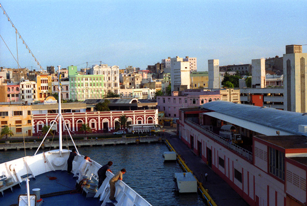
Once again, the docking procedure was interesting; but this docking was different in that we were right in the middle of town. The old city was right in front of us. Here are a couple more views from our arrival:
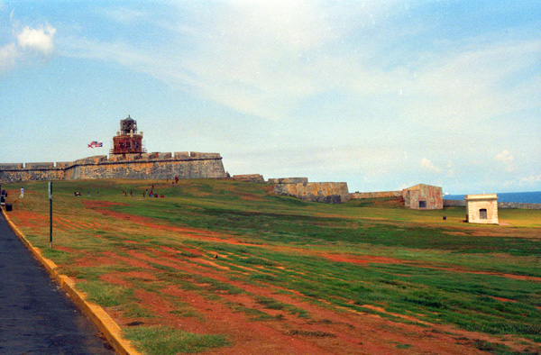
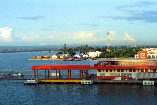 The Port Side View from the Ship There is a cruise ship dock, then a Navy facility and beyond that the channel that leads out to the ocean; you can just barely make out the ocean at the upper left. The docks are actually on the Southern side of a peninsula of land that runs from East to West and protects the harbor. San Juan is the area's major port. |
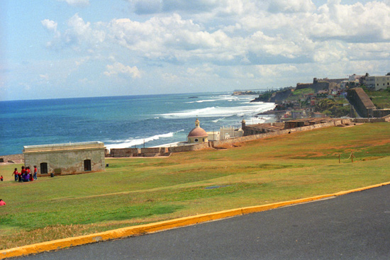
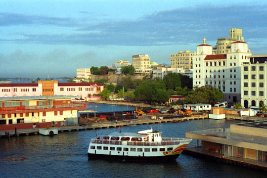 The Harbor Area at San Juan, Puerto Rico I took this picture from the port side just to get more of the harbor area. At right is the old town of San Juan; San Juan is a large city and runs all along the north shore. Beyond those buildings is El Morro, an old fort that we'll visit today. You can see more empty docks waiting for ships and also one of the ferries that ply this end of the island. |
Our Walk Through Old San Juan to Morro Citadel
|
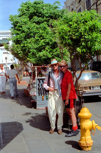
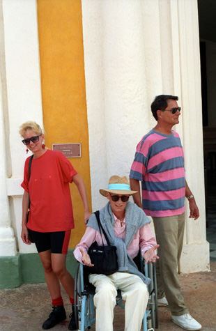
Everyone was fresh this morning, and I took this picture of Patty and Grant on the street in front of the Costa Riviera. Right in front of the dock is one of the busier shopping areas of San Juan. We stopped just after getting off of the ship so Patty and I could take some pictures. Grant was not in his wheelchair yet, so I asked him to stand with Patty to get this picture. The weather was warm and quite humid, and I knew it would be a chore pushing the wheelchair around, but I wanted Grant to see as much as possible without getting too tired.
The first stop we made was the large jewelry store across the street. They served free pińa coladas and sodas for shoppers in the store, and we all browsed around looking at everything. Patty bought some small items, and Grant found a nice sterling silver anchor that he liked. Then we left the store and went through the streets of the shopping district, stopping in a few stores as we went, heading out to the end of the peninsula and a place called Morro Castle.
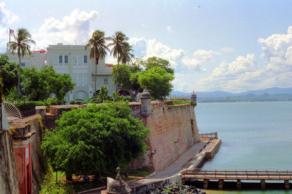
We went up and down some hills and through a small park, me pushing Grant all the way. It was a bit tiring, but there was a breeze and that was nice. I just had to keep the wheelchair away from traffic, and I had to maneuver it over curbs and stuff. It really made me appreciate the mandated wheelchair access ramps on most new sidewalks in America. Actually, we were following some helpful signs that were pointing us to the Citadel. Eventually, we had to turn more to the north; we were right in front of a building called La Fortaleza. We were still able to walk along fairly close to the edge of the harbor.
La Fortaleza (The Fortress) is the current official residence of the Governor of Puerto Rico. It was built between 1533 and 1540 to defend the harbor of San Juan. The structure is also known as Palacio de Santa Catalina (Santa Catalina's Palace). It is the oldest executive mansion in continuous use in the New World. It was listed by UNESCO in 1983 as part of the World Heritage Site "La Fortaleza and San Juan National Historic Site".
During the 1640 reconstruction, the chapel of Santa Catalina, which originally existed outside of the walls, was demolished and was integrated to the walls of the structure, resulting in the alternate name Santa Catalina's Palace. Shortly after turning north, we came out into the open area at the foot of the Morro Citadel, and from here, we had a nice view back towards La Fortaleza. La Fortaleza was the first defensive fortification built for the city of San Juan, and the first of a series of military structures built to protect the city which included the Fort San Felipe del Morro and the Fort San Cristóbal.
|
At present, the complex consists of a few attached buildings with formal living quarters in the second floor, and private quarters in the third. It overlooks the high city walls that front the bay, and within the north perimeter of the house are sheltered gardens and a swimming pool.
Since the 1500s, La Fortaleza has been the residence of the Governor of Puerto Rico; a reconstruction that began in 1846 changed its appearance from a military fortress to a civilian office/residence. La Fortaleza has been the residence of more than 170 governors of Puerto Rico and has hosted kings, queens and Presidents. It has had some not so cordial visitors, too; it has been captured twice by invaders once in 1598 by the Earl of Cumberland and again in 1625 by Netherlands military forces. According to tradition, in 1898, just before the United States invaded Puerto Rico during the Spanish–American War, the last Spanish governor of the island, Ricardo De Ortega, struck a longcase clock in La Fortaleza with his sword, stopping the clock and marking the time at which Spain lost control over Puerto Rico.
In 1950, in what is known as the San Juan Nationalist revolt, men intending to attack then-governor Luis Muńoz Marín entered La Fortaleza. The 5-minute shootout resulted in four Nationalists dead and three guards seriously injured. In 1960, La Fortaleza was designated a United States National Historic Landmark, and in 1983 it and the San Juan National Historic Site was declared a World Heritage Site by UNESCO.
|
Lying on the northwesternmost point of the islet of Old San Juan, Castillo San Felipe del Morro is named in honor of King Philip II of Spain. The fortification, also referred to as el Morro or 'the promontory,' was designed to guard the entrance to the San Juan Bay, and defend the Spanish colonial port city of San Juan from seaborne enemies. Over 1.5 million visitors a year explore the castillo, making it one of Puerto Rico's leading tourist attractions. Facing the structure, on the opposite side of the bay, a smaller fortification complemented the castillo's defense of the entrance to the bay.
The construction of the citadel and its surrounding walls began in 1539 on orders of King Charles V of Spain. Its main purpose was to defend the port of San Juan by controlling the entry to its harbor. In order to have a viable defense while the rest of the fort was being completed, a small proto-fortress (about 10% of the final structure) was erected during the first year. The final design was completed in 1587, and it was based on the design of some ten similiar fortresses throughout Latin America.
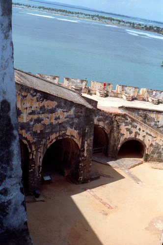
Many complex structures were added onto El Morro over the next 400 years to keep up with the new military technologies; for example, El Morro's outer walls, which were originally constructed 6 feet thick, had been augmented to 18 feet by the end of the 18th century. In 1680, construction began on city walls for San Juan; these were completed in 1728. Today, El Morro has six levels that rise from sea level to 145 feet high. All along the walls are seen the dome-covered sentry boxes known as garitas, which have become a cultural symbol of Puerto Rico itself. The Lighthouse of the Castillo San Felipe del Morro was built atop the citadel in 1843, but was destroyed during the 1898 bombardment of the city by the United States; it was replaced by the US military with the current lighthouse in 1908.
|
|
Once we were inside the citadel, Grant was able to get up and walk around for a while, which was good because many of the corridors and such were fairly narrow. We both enjoyed wandering around and looking at the views.
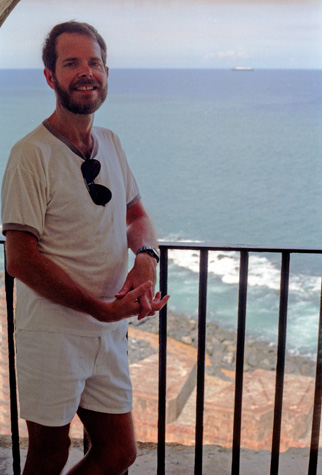
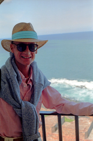 Grant at a Balcony in Morro Castle |
(Picture at left) This was a nice photo venue, so we took pictures of each other. Grant has lost a good deal of weight, and much of his natural insulation as well; he always feels chilled as a result. So even though it was quite warm (and I took my shirt off when I was pushing his wheelchair), Grant was comfortable dressed like he was.
(Picture at right)
|
 Me on the Morro Castle Balcony |
Here are a couple more pictures that I took as we were walking through the citadel and looking at the various exhibits:
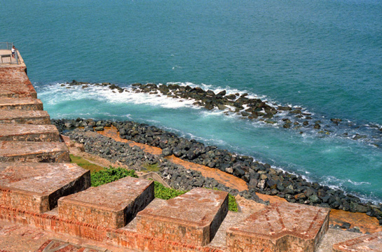 The Puerto Rican Shoreline Seen from the Citadel The gunsights were added after the invention of firearms, and you can see they are constructed so that every inch of the beach approach is covered by line of sight fire zones. Very effective. |
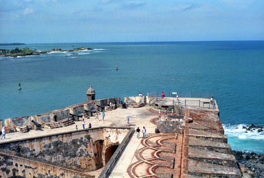 Looking West Across the San Juan Harbor Entrance This is an excellent picture to show you how the Fort commanded the entrance to the harbor. No ship could sail in without being subjected to a long stretch where it was vulnerable to fire from the fort. Those semicircles are the old tracks for the movable cannon. |
The large cannon were placed and fixed so that they could be rotated 180 degrees to cover the entire approach area. There was another cannon at the very end that covered the harbor approach itself. You can also see the steps on which the riflemen must have stood when necessary, and you can also see into the lower levels of the fort through that opening at the bottom right of the pictures above. Also, note the symbolic dome structure so typical of Puerto Rico that it has become one of its national symbols.
|
We were both having a good time, particularly since Grant was feeling OK today. I am continually struck by the effect that HIV has had on Grant's appearance (and on the appearance of other friends I have known). It of course has made him look much different than during our first few years together.
I know that Grant is very much aware of all this but, as I have told him repeatedly, it is the person inside that I fell in love with, not the outside appearance. Those who base their relationships on how each other look when the relationship begins, then it seems to me as if that relationship is doomed, sooner or later, to failure. Beauty, like glory, is fleeting.
Although I have a couple more pictures taken at the citadel, I might point out that it was just after noontime when we left the citadel, and on our leisurely walk back to the dock we found a charming little cafe where we sat down to have a light lunch. Given that we'd had a good breakfast, we thought that would be enough until we got back on board for the mid-afternoon snacks.
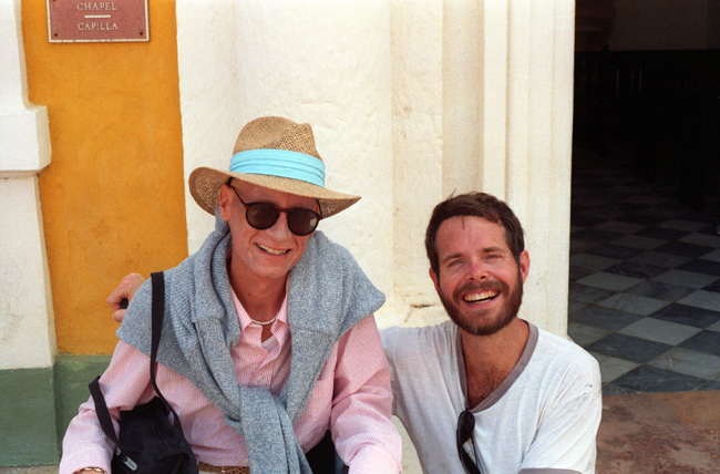
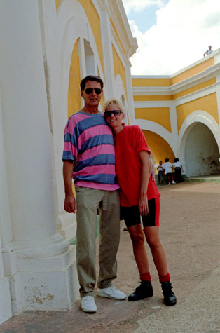 Don and Patty at Morro Castle |
(Picture at left) This picture was taken in the main entry courtyard of the citadel. In this part of the castle there are some small shops and other facilities, and some typical rooms that have been somewhat restored that you can go into. All the painting, of course, is part of the restoration.
(Picture at right)
|
 Patty, Grant, and Don at the Citadel |
In addition to having a bit of lunch, we stopped in a number of shops on the way back from the castle, including another new Baskin-Robbins for my list, and we bought some T-shirts and I picked up a light jacket for Larry that had a picture from San Juan on the back. We looked in innumerable jewelry stores, but found little that we wanted to buy. By the time we got back to the ship it was the middle of the afternoon, and everyone was getting
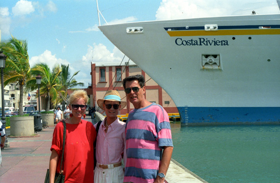 Patty, Grant, and Don at the Costa Riviera I suppose I should have a tripod for situations like this, but I first thought that I would take this picture and then perhaps switch out with Don or Patty for a second. |
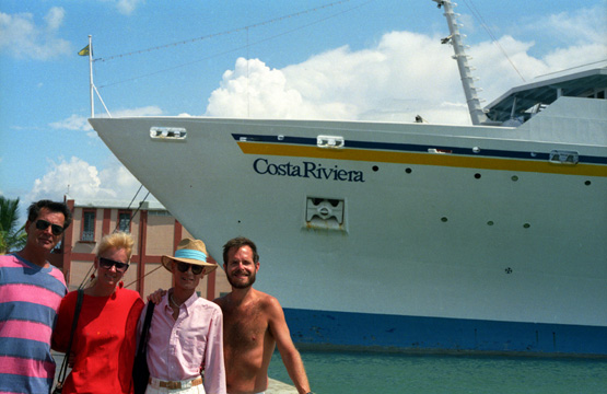 Our Group in Front of the Costa Riviera Fortunately, an obliging passenger came along, returning from their own walk ashore, and I prevailed on them to take a picture of all of us. They cut Don off a bit, but the picture turned out OK. |
Walking through Old San Juan to Morro Citadel was certainly interesting, and I didn't find that pushing Grant was any kind of difficulty- save for the city streets that didn't have handicap ramps cut into the curbs. There were some cobblestone streets and I know that Grant got bounced around occasionally.
Well, we got back on board in the early afterrnoon, relaxed for a while and had a drink at the pool. I left Grant with Patty and went to change for some jogging on the "track". (I might have gone jogging in San Juan, but didn't want to risk getting lost and perhaps missing our sailing. That night we had what was billed as a "Renaissance" dinner, which turned out to be various dishes reminiscent of dining in an old castle in the middle ages, but it was hard to see the real connection. There were some good Italian dishes that I sampled, though.
After dinner, I played some bridge with Lynn's mother until her regular partner arrived, and then I spent some time with Grant and Patty and Don. When Grant felt like going back to the cabin to read, I took the opportunity to go to the theater and watched part of "Thelma and Louise". Then it was back to the cabin to help Grant with his medications and then bed.
You can use the links below to continue to another album page for our Caribbean cruise or return to the cruise index page to continue on through the photo album.
|
October 24, 1991: A Sea Day Aboard the Costa Riviera |
|
October 22, 1991: A Visit to St. Thomas, USVI |
|
Return to the Caribbean Cruise Index |