|
October 26, 1991: Arriving in Fort Lauderdale |
|
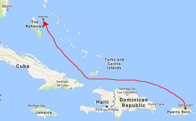
October 24, 1991: A Sea Day Between San Juan and Nassau |
|
Return to the Caribbean Cruise Index |
Friday was our last port of call- the town of Nassau in the Bahamas.
|
This morning we had breakfast up on the Lido deck by the swimming pool, and then Patty and I got some sun while Don and Grant talked down below us.
 |
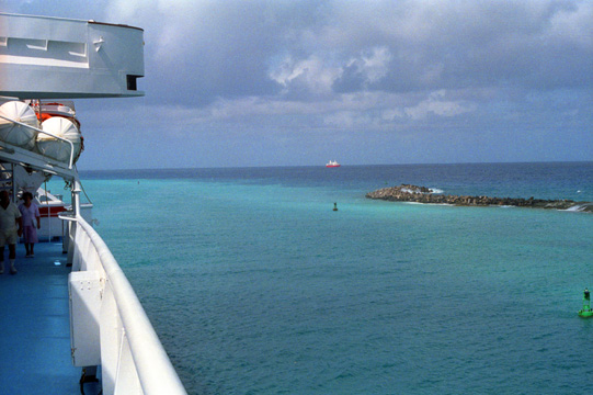
Then about noon we could see the Bahamas come into view, and a little after that we were heading into Nassau harbor. The color of the water was reminiscent of Hawaii- lots of blues and shades of green. We all went up on the top deck to watch the process of coming into our berth at the Nassau cruise ship terminal.
Docking in Nassau
|
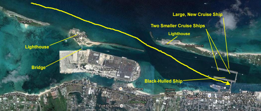
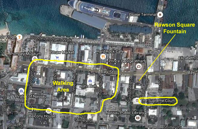
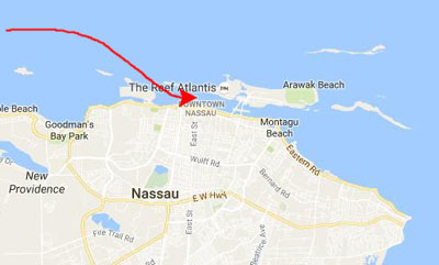
On the aerial view at left, courtesy of Bing Maps, I have marked some of the natural and man-made features that you will see in the various pictures. We passed a lighthouse coming in, which turned out to be on Crystal Cay (in case you are curious, the words "cay" and "key" are interchangeable, although the "cay" spelling is closer to the original Spanish word "cayo" meaning a low island. Both words are typically most used when talking about such islands in the area of the Caribbean, as in "Key West"). You will also see the arched bridge that leads to this key from Arawak Cay, which, as we passed, seemed to be mostly commercial; at least I didn't see any residences to speak of. We passed much closer to the lighthouse at the northwest end of Paradise Island.
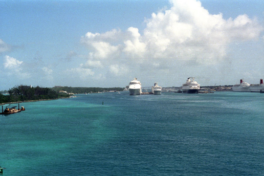
In the aerial view, you will see the three-dock cruise terminal, although in the aerial view, there is only one ship in port, docked on the north side of the southernmost pier. The Costa Riviera will be docking on the south side of the middle pier; on the other side of that pier you will see a large ship with a black hull. In our pictures, both sides of the northernmost pier are also full; there are two small cruise ships on the south side of that pier and on the north side one of the newest cruise ships which, as you can see, is a good deal larger than anything else around (but that's been the trend in cruising since the late 1980s- more passengers on larger and larger ships).
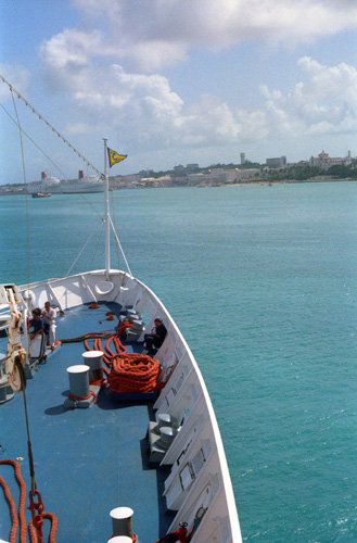
 Looking North from the Port Side Here, I am on the forward port side of the ship, looking back the way we have come as we enter the harbor at Nassau. The ship in the distance is the same one that was docked behind us in St. Thomas. Ships from different lines often have similar itineraries and often end up together in multiple ports. |
 Looking Ahead to the Nassau Cruise Ship Port We have just entered the harbor area after taking on the Nassau harbor pilot. Ahead you can see the boats already docked; our empty dock will be to the right of the third ship from the left. The ship coming in behind us will be docking closest to downtown Nassau, to the right of the rightmost ship in this picture. |
In the two pictures below, note how the direction of the light can make the water inside the harbor appear to be very different in color.
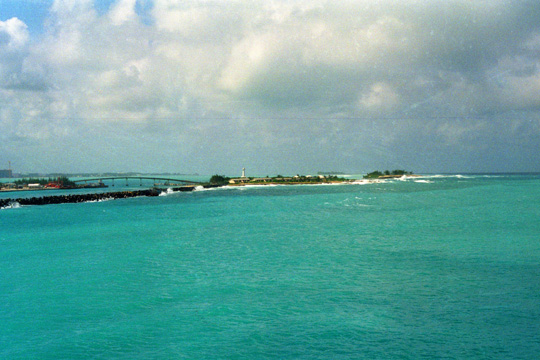 Arawak Cay and Crystal Cay I went over to the starboard side of the ship to get this view looking back southwest after we passed Crystal Cay. You can just barely see the lighthouse on the cay, and you can also see the bridge to it from Arawak Cay. |
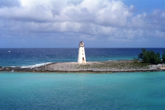 The Lighthouse on Paradise Island This is actually a man-made breakwater at the northwest end of Paradise Island. Paradise Island shelters the Nassau harbor, and there are a couple of bridges over to it beyond the cruise ship docks. Note how blue the water is on the ocean side, and how much more green it is in the harbor. |
I went as far forward as I could to get the next two pictures as the ship turned to starboard to line up with our dock.
|
|
Although it looks shallow, the water here must be at least twenty or thirty feet deep. Grant was having a good time watching the ship go through its paces as it entered the harbor. Much different than bringing the S2 into its dock on Lake Ray Hubbard!
As the ship turned, I realized that I would need to be on the stern to get pictures as we came into the dock, so Grant and I walked back there, and went down one deck for a more unobstructed view.
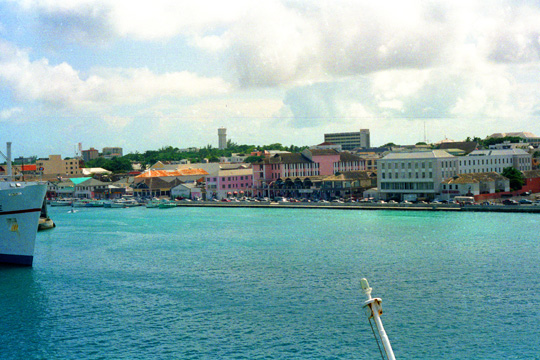 The Town of Nassau, Bahamas The Costa Marina continues to turn, and we are also sliding closer to the docks and the town of Nassau. This is a good view of just about the entire town, although you can't see much detail here. |
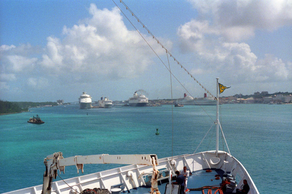
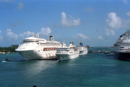 Cruise Ships Docked at Nassau This view was taken from the starboard side of the ship near the stern. We are pretty much stern first, now, and sliding backward to dock at the right side (as this picture is oriented) of the ship at the extreme right of the picture. |
I thought the disparity in the sizes of the various cruise ships was interesting. The Costa Riviera is somewhat larger than either of the two smaller ships you see above, right, but much smaller than the large Princess ship to the left. Where our ship carries about 1800 passengers and 800 crew, the Princess ship can carry more than twice that number of both passengers and crew. Cruising on a ship that big, with all that there must be to do, would be very different, I think, but it might be nice to try a ship that size at least once (which, as it turned out, would happen about fifteen years hence).
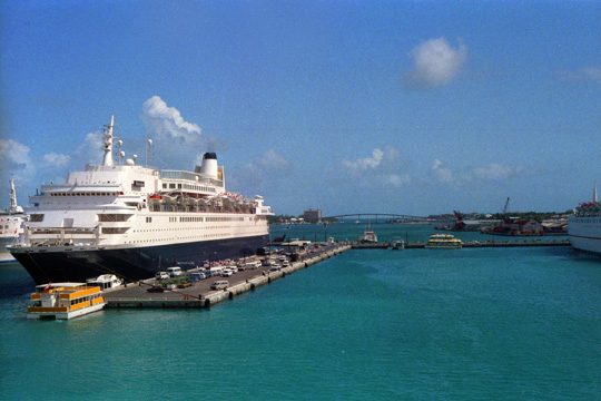 Our Berth at Nassau, Bahamas The ship is now stern first and backing slowly into the dock- much of which, Grant told me, will be accomplished by inertia. The harbor pilot knows just when to apply a bit of reverse engine power to stop the backward motion. Imagine backing into a parking space when your car can also move laterally; that complicates things.The afternoon is warm, but there is a nice breeze. |
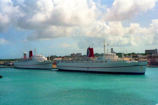 Two Cruise Ships Docked South of Us I don't know enough about the cruise line insignia to tell you which line these ships belong to, but I think that they are Carnival Cruises ships. I suppose that folks who do lots of cruising get to know all the different lines (and perhaps cruise on many of them). The town of Nassau is behind those ships. |
The harbor pilot did indeed apply the reverse engines at just the right time, and we came to rest about six feet from the dock to the starboard side of the ship and about thirty feet from the stern to the walkway from the docks into the town.
|
Patty and Don wanted to go off shopping on their own, so Grant and I were going to go by ourselves. Grant was a bit tired, so I again arranged for a wheelchair for him. Actually, it is a lot of fun to push him around, and I know that he doesn't mind the attention.
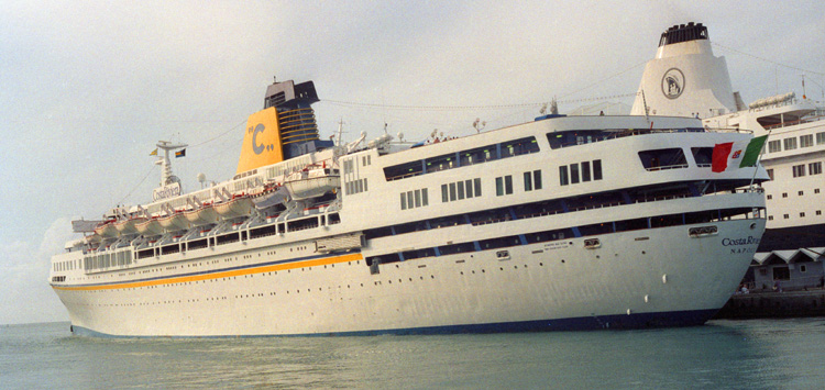
As we were strolling down the broad north-south pier towards the town, I stopped and took this shot of the entire length of the Costa Riviera as close as I could get. Our cabin is way up towards the bow, on the inside, on the same level as the row of black windows underneath the lifeboats. The dining room is on that same level, but also inside so there are no windows. The swimming pool is on the top deck at the stern, and there are stairways that lead down from the swimming pool to the successively lower and lower decks. A couple of times Grant and I went down to that bottom deck to watch the wake of the boat both at night and in the daytime. Some of the pictures of Don and Patty on deck after dinner were taken near where the flag is fluttering on the stern.
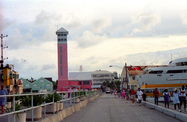
Then we continued down the pier and through a checkpoint where passengers had to present their ship ID cards (which you also have to present each time you get off the ship or back on it). Then we were in the town of Nassau.
Walking Around Nassau with Grant and Then Lynn
|
Nassau's modern growth began in the late eighteenth century, with the influx of thousands of American Loyalists and their slaves to the Bahamas following the American Revolutionary War; eventually came to outnumber the original inhabitants. Today the city dominates the entire island and its satellite, Paradise Island. However, until the post-Second World War era, the outer suburbs scarcely existed.
After the British abolished the international slave trade in 1807, they resettled thousands of Africans liberated from slave ships by the Royal Navy on New Providence, along with other islands such as Grand Bahama, Exuma, Abaco and Inagua. In addition, slaves freed from American ships, such as the Creole case in 1841, were allowed to settle there. The largest concentration of Africans historically lived in the "Over-the-Hill" suburbs of Grants Town and Bain Town to the south of the city of Nassau, while most of the inhabitants of European descent lived on the island's northern coastal ridges.
Nassau was formerly known as Charles Town; it was burned to the ground by the Spanish in 1684. It was rebuilt and renamed to Nassau in 1695 under Governor Nicholas Trott. Due to a lack of effective Governors (after Trott), Nassau fell on hard times. In 1703 Spanish and French allied forces briefly occupied the city.
|
From 1703 to 1718 there was no governor in the colony and by 1713, the sparsely settled Bahamas had become a pirate haven. The Governor of Bermuda stated that there were over 1,000 pirates in Nassau and that they outnumbered the mere hundred inhabitants of the town. They proclaimed Nassau a pirate republic, establishing themselves as "governors". Examples of pirates that used Nassau as their base are Charles Vane, Thomas Barrow, Benjamin Hornigold, Calico Jack Rackham, Anne Bonny, Mary Read, and the infamous Edward Teach, known as "Blackbeard".
In 1718, the British sought to regain control of the islands and appointed Captain Woodes Rogers as Royal governor. He successfully clamped down on the pirates, reformed the civil administration, and restored commerce. Rogers cleaned up Nassau and rebuilt the fort, using his own wealth to try to overcome problems. In a short two years, Nassau was strong enough to repel an attempt by the Spanish to capture the town.
During the run-up to the Revolutionary War, Nassau experienced an economic boom. With funds from privateering, a new fort, street lights and over 2300 sumptuous houses were built and Nassau was extended. In addition to this, mosquito breeding swamps were filled.
|
In 1776 the Battle of Nassau resulted in a brief occupation by American Continental Marines during the American War of Independence, where the Marines staged their first amphibious raid on Fort Montague after attempting to sneak up on Fort Nassau. In 1778 after an overnight invasion, American raiders led by Captain Rathburn, left with ships, gunpowder and military stores after stopping in Nassau for only two days. In 1782 Spain captured Nassau for the last time when Don Juan de Cagigal, governor-general of Cuba, attacked New Providence with 5000 men. Andrew Deveaux, an American Loyalist who resettled on the island, set forth to recapture Nassau with 220 men and 150 muskets to face a force of 600 trained soldiers. Deveaux forced the Spanish to surrender on April 17, 1783, without a single shot fired.
In the late 1700s, Fort Charlotte and Fort Fincastle were constructed, and during the American Civil War, Nassau served as a port for blockade runners making their way to and from ports along the southern Atlantic Coast for continued trade with the Confederacy. Nassau also profited greatly during Prohibition, becoming a haven for smugglers taking liquor distilled in the Caribbean into the United States.
This was our only stop in the Bahamas which, of course, are much larger than just the island of New Providence. The Bahamas consists of more than 700 islands, cays, and islets in the Atlantic Ocean. The designation of "The Bahamas" can refer to either the country or the larger island chain. In fact, the territory of the Bahamas actually encompasses 180,000 sq mi of open ocean.
The Bahamas were the site of Columbus' first landfall in the New World in 1492. At that time, the islands were inhabited by the Lucayan, a branch of the Arawakan-speaking Taino people. Although the Spanish never colonised the Bahamas, they shipped the native Lucayans to slavery in Hispaniola. The islands were mostly deserted from 1513 until 1648, when English colonists from Bermuda settled on the island of Eleuthera.
The Bahamas became a British Crown colony in 1718, when the British clamped down on piracy; slavery was abolished on the islands in 1834. The islands became a haven for freed and escaped slaves, and today the descendants of slaves and free Africans make up nearly 90% of the population. The Bahamas became an independent Commonwealth realm in 1973, retaining Queen Elizabeth II as its monarch. In terms of gross domestic product per capita, the Bahamas is one of the richest countries in the Americas (following the United States and Canada). Its economy is based on tourism and finance.
I marked on the city view above the general area where I walked and shopped with Grant; we just went up one street and down another-whatever looked interesting.
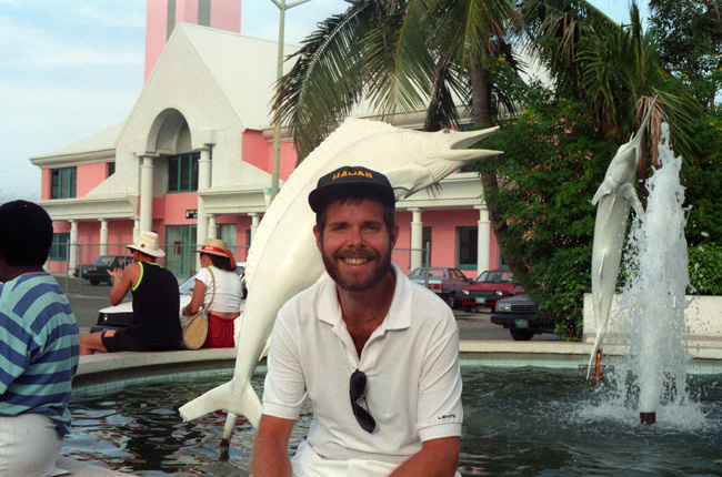
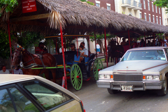 A Street Scene in Nassau Nassau is just as modern as anyplace else in the world, and the only touches of old world charm are specifically for the tourists. Here, you can ride in a horse-drawn carriage if you want, but they are certainly not a normal mode of transportation here. I wheeled Grant across the street and then returned to this point for a picture. |
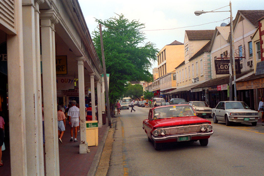 A Typical Shopping Street in Nassau In the main shopping district of Nassau, the shops are mostly small, and specialize in one and only one thing- items that tourists might want to buy. Clothing, T-shirts (and more T-shirts), jewelry, perfume, liquor, wood items, carvings and so on are all prominently displayed. |
I wheeled Grant into and out of quite a few stores here; he didn't want to buy anything in particular, but we were both just looking around. After a while, Grant got pretty tired of window shopping, and we made our way generally back to Prince Georges Wharf and the Costa Riviera. We stayed on board the ship for a while, having a snack and a drink by the pool. Then we ran into Lynn, and she sat with us for a while. When she said she'd been with her mother most of the afternoon but wanted to go into town for a while, I volunteered to make a second trip into Nassau to accompany her (not because Nassau isn't safe, but because I thought I might get a few more pictures and because Lynn is such a nice person).
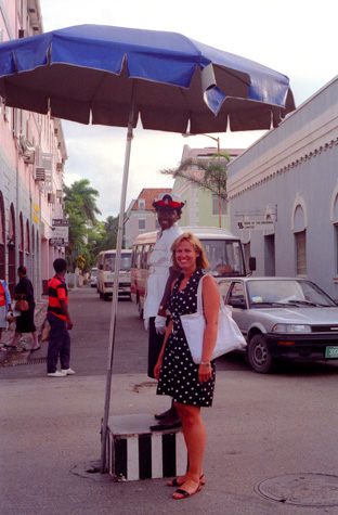 |
(Picture at left) Here is Lynn in the middle of an intersection where there was a white-suited policewoman directing traffic. I thought that it would add some interest to the picture if I could get Lynn to stand on the box with the policewoman, but there wasn't room, so I settled for this shot.
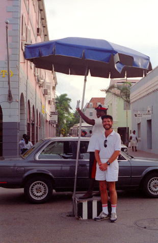
(Picture at right)
|
 |
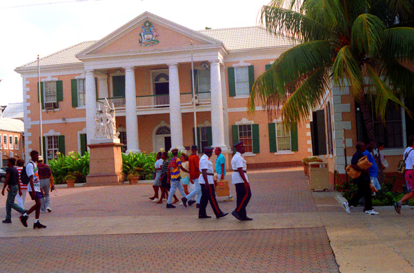
On the way back to the ship, Lynn and I walked through a large park between the Parliament Building and the Wharf- this was Rawson Square.
|
The fountain was just in front of the Parliament House, and features some cement dolphins cavorting in the water. Just the background for a picture which Lynn was happy to take for me.
We just wandered around for a while and talked; Lynn was very interested in what Grant was having to go through because of his illness, and she insisted that if we ever needed anything that she might be able to help with, we should call her. I gave her our address and telephone number, so that she could call if she wanted to. Then we walked back to the ship. Just before we turned to walk down the dock back to the gangway, I had an opportunity to photograph the Costa Riviera from the stern, a view I'd not had so far.
Based on the twin pillars of tourism and offshore finance, the Bahamian economy has prospered since the 1950s. However, significant challenges in areas such as education, health care, housing, international narcotics trafficking and illegal immigration from Haiti continue to be issues.
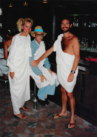
Toga Night Aboard the Costa Riviera
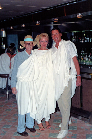 |
(Picture at left) Here are Grant, Patty and Don in their toga outfits. I didn't expect that Grant would want to do more than wear the sheet over his clothes, which is exactly what he did. Even so, he was more appropriately attired than many aboard ship. This shot was taken before dinner in the Lounge.
(Picture at right)
|
 |
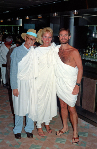
I should say a word about the next few pictures. In contrast to literally everyone else who simply wore the sheet over their street clothes or who had come prepared with an actual article of clothing or dress that looked like a toga (as Lynn's mom did), I thought that if you were going to get into the spirit of being a Roman then the toga should be worn as it was then- as just about the only article of clothing save for a singlet or other undergarment; so I wore mine without anything else. I found a way to tie the toga so that it covered everything it needed to cover, and the only things I wore other than the sheet were my sandals and my watch.
 |
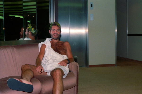
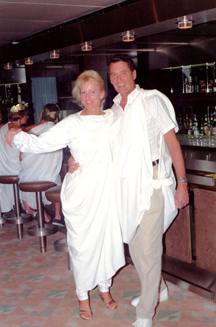
(Picture at left) Here are Grant, Patty and I in our toga outfits. I didn't feel conspicuous at all; perhaps that is a benefit of having gone to the bar barechested quite often. I got a few stares; I seemed to be the only male who wasn't wearing a shirt or pants with the sheet. It was fun, and I enjoyed being a bit exhibitionistic.
(Picture at right)
|
 |
I took one picture just looking out across the dining room, and you can see a lot of the people with their togas. The picture didn't turn out that well, but if you want to see it, you can just click here.
|
|
We had stopped in to the lounge after dinner to listen to the music; I had fun wearing the toga, but wouldn't want to do it as a steady diet.
We listened to music for a while, and then we all went back to our cabins to get out of our toga outfits, and then we gathered together for a last evening drink of the cruise. We went up to the Lido deck by the swimming pool, and listened to the steel drum music for a while until we all got tired. Grant and I retired and left Patty and Don on deck.
I could tell that Grant had been getting more and more worn and tired as the cruise progressed; I thought it was good that we would be docking tomorrow, so that he could get back to his familiar surroundings, and not have to go to a dining room to eat when he didn't feel like it. I, too, was looking forward to getting home, not just to the condo in Ft. Lauderdale, but home to Dallas.
You can use the links below to continue to another photo album page for our Caribbean cruise, or you can return to the cruise index page to continue through the photo album.
|
October 26, 1991: Arriving in Fort Lauderdale |
|
October 24, 1991: A Sea Day Between San Juan and Nassau |
|
Return to the Caribbean Cruise Index |