|
March 20, 1993: Hemisfair and the Trip to Leakey |
|
March 18, 1993: A Day in Austin |
|
Return to the South Texas Trip Index |
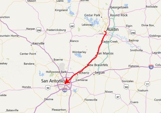
We actually drove down to San Antonio last night after spending a day in Austin.
|
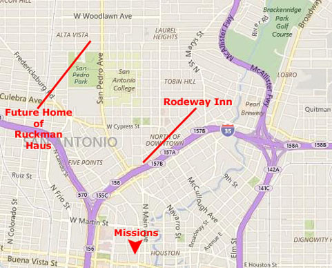
There, we checked in to the Rodeway Inn where Fred had stayed before and where we had made a reservation a few days ago. It was late, so we didn't do much more than get settled in to the hotel and get to sleep.
I can't resist noting here that driving to San Antonio will eventually become by far our most frequent trip together (with Florida a close second). In another year, I'll be introduced to Prudence Lucas, one of Fred's oldest friends, and then to her sister, Nancy. Fred and I will eventually go out with the two of them quite a few times to dinner and a movie, and the two of them will become frequent guests at our birthday parties. In 1999, Prudence will marry Ron Ruckman, and together they will move to San Antonio in 2000 to renovate an old house near San Pedro Park and open it as Ruckman Haus- a bed and breakfast. We will begin visiting them frequently, particularly as I will be helping Prudence create a website for the B&B. Now, as I write this in 2016, I can report that the B&B was open for 13 years before the Ruckmans retired from the hospitality business.
I also can't resist telling you, the reader, that the first publicly-accessible website will go online 11 days from now. By the end of this year, there will be over 120 websites online. By the time I create the website for Ruckman Haus, there will be some 18 million sites. Today, as I write this, the total has passed 1 billion, with new ones being created at a rate of about one per second.
Fred and I will spend all day here in San Antonio, seeing some of the sights. Frank and Joe will be joining us from Leakey late this afternoon, and together we will have dinner, stay the night, and then head out to their place in the Hill Country tomorrow.
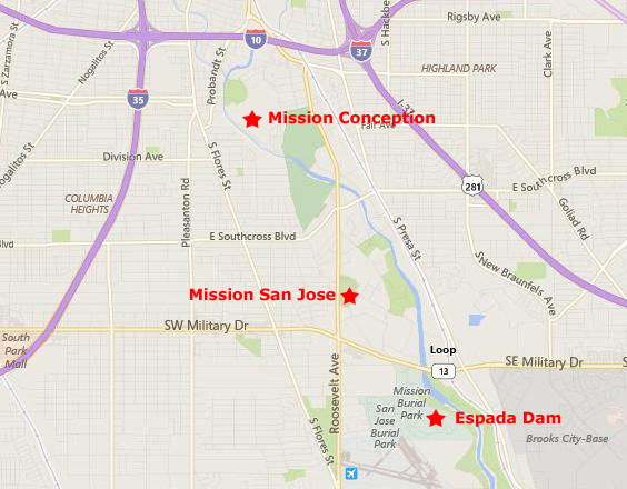
The San Antonio Missions National Historical Park
|
The four missions within the park are, in order from north to south, Mission Concepción, Mission San Jose, Mission San Juan, and Mission Espada. The Espada Aqueduct, also part of the Park, is due east of Mission San Juan, across the river. The fifth (and best known) mission in San Antonio, the Alamo, is not part of the Park. It is located upstream from Mission Concepción, in downtown San Antonio, and we will visit it today as well.
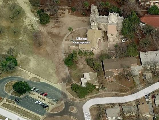
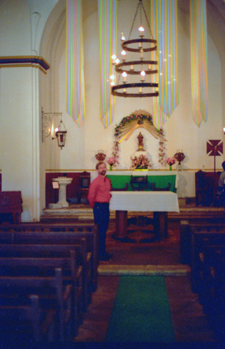
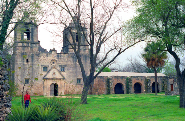
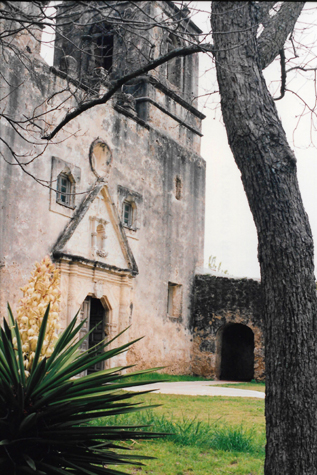
Mission Concepción
|
 Mission Concepción |
Mission Concepcion consists of a sanctuary, nave, convento, and granary. When originally built, brightly painted frescos decorated both the exterior and interior of the building. Traces of the frescoes still exist on the weathered facade of the building. Experts restored some of the artwork on the interior ceilings and walls of the convento in 1988.
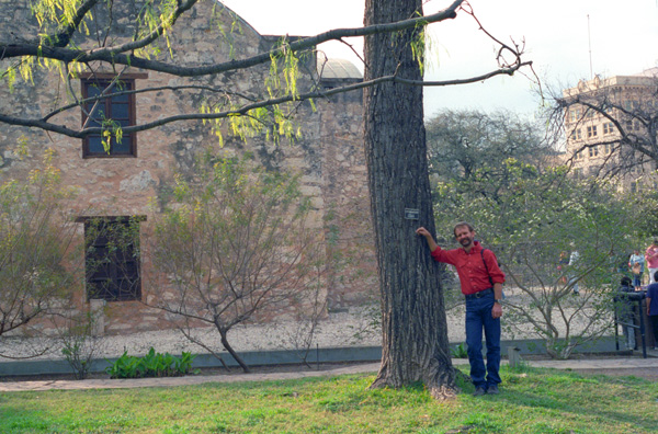
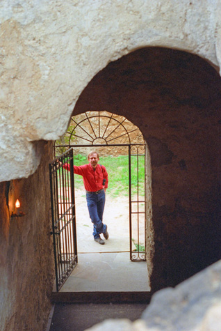
 Me at Mission Concepción |
(Picture at left) Mission Concepción dates from the early 1700s, and is relatively small. You can wander through the entire mission, which is today just a church and some connecting buildings- still an active parish. As we went through the mission, we encountered this stairway and wrought iron gatework. Fred took this picture of me standing part way up the stairs which led to a room above the church, presumably used by the priests as an office of some type. The stonework in this mission dates from the original founding, and is by now very uneven and worn. But the church is still in use today.
(Picture at right)
|
 Fred at Mission Concepción |
The entire mission was much simpler than most churches that I have been in; this simplicity was characteristic of provincial churches in the New World; elaborate adornment, common in Europe and in the big cities, was relatively unknown in the hinterhands. Concequently, the sanctuary of this and other Spanish missions is very simple. There is some adornment (and in wealthy Spanish Catholic churches quite a lot of adornment), but the areas used by the worshippers are usually quite plain.
|
 |
The stairway and the upstairs room are at the back center of the mission. The wing at the right contained small rooms used by the church or mission staff. There was also a little shop where you could buy souvenirs, and I imagine that is how the church makes some of the money it needs to operate.
 |
(Picture at left) Here is the front of Mission Concepción. Fred took this picture, and thought that the gnarled tree and the yucca made an interesting composition.
(Picture at right)
|
 |
The mission and its property are part of the Historic Park, and we wanted to see more of it. After touring this mission and snacking on some pastry that Fred had bought at a Spanish bakery on the way here from the hotel, we set off down the road about two miles to the largest of the missions in the Historic Park- the Mission San Jose.
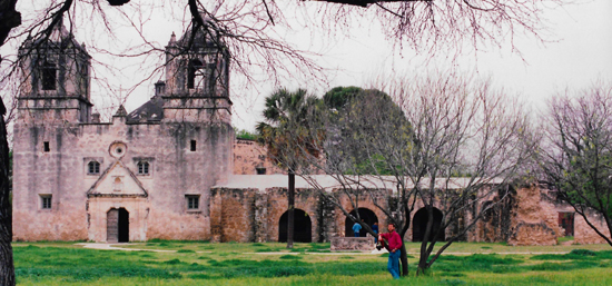
Mission San Jose
|
The first buildings, made of brush, straw, and mud, were quickly replaced by large stone structures, including guest rooms, offices, a dining room, and a pantry. A heavy outer wall was built around the main part of the mission, and rooms for 350 Indians were built into the walls.
A new church, which is still standing, was constructed in 1768 from local limestone. The mission lands were given to its Indians in 1794, and mission activities officially ended in 1824. After that, the buildings were home to soldiers, the homeless, and bandits. Starting in 1933, the Civil Works Administration and then the Works Progress Administration provided the labor to rebuild and restore the grounds of the mission. Some of the funding for the restoration came from money allotted by the United States for the Texas Centennial Exposition held in Dallas in 1936. The mission walls and Indian quarters were re-built, and the granary was restored.
The church facade features from the top: a cross, representing Jesus Christ, St. Joseph (San Jose) holding the infant Jesus, St. Dominic and St. Francis, Our Lady of Guadalupe (the Virgin Mary), and St. Joachim and St. Anne holding the infant Mary. We came in the main entrance at the southeast corner of the outer wall, and began our tour through the complex.
|
 |
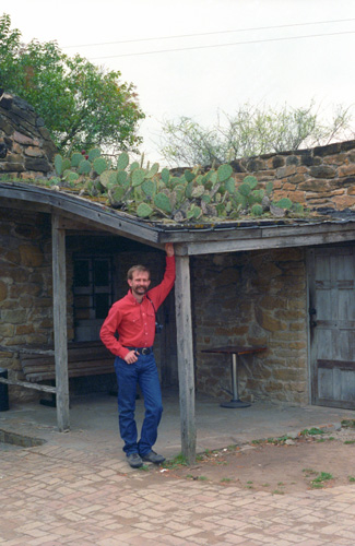
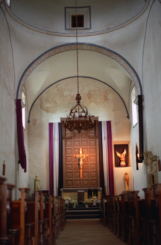
Mission San Jose is the largest of the missions in the Park, and almost all of the buildings in the complex are the original ones. You can tell that the walls have been here for some time as there is cactus growing on the roof. As we began to walk through the complex, the day was overcast, and rain was threatening. We followed the walkway along one wall of the mission, passing the long line of rooms for Indians, and then behind the chapel, where there were quarters for the mission priests and staff. In one room there was a diorama of what the courtyard of the mission must have looked like when it was in full service. We walked down a path to the mill house, where grinding corn into flour was done. Then we went to the main chapel.
|
|
Our actual route through the mission took us from the old mill into that main chapel entrance, and then we exited through some preparatory rooms and a small chapel to the outside arbor arcade "behind" the main chapel building. I was not sure what the purpose of this multiple row of arched arcades; they weren't holding up anything, and they weren't like an aqueduct. There were some gardens around, but still I didn't know the purpose. We did take a few good pictures here.
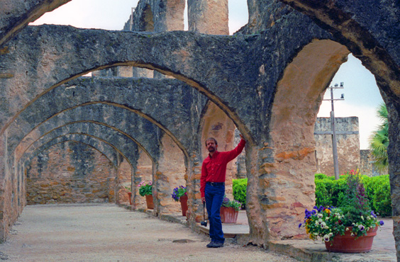 Fred outside the chapel at Mission San Jose I thought that the symmetry of the overhead buttresses presented an interesting picture. Note all the moss and ivy that has grown on the stonework. |
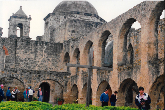 Me outside the main chapel at Mission San Jose I am carrying some items that I bought in the little shop at the mission; a map of this are of the country circa 1750 and some souvenir stamps of the historic site area. Fred thought also that the overhead stone work presented an interesting picture, but he is taking this from the other end looking back. |
Actually, a little later on when I had a chance to look closely at the guidebook, I discovered that the area where the arched walls were had once been an enclosed building, but that the second story had given way, and just an open passageway was left. I can't see any other reason why the walls should have been built the way they were.
|
The other two sides of the rectangle were simply stone walls with some occasional small buildings built attached to the wall inside the rectangle. It was intended that the mission be as easy to defend as possible, since many people actually lived inside the mission in the broad area that you see here. The picture is dark because the day was dark and it was starting to rain lightly.
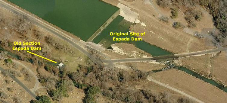
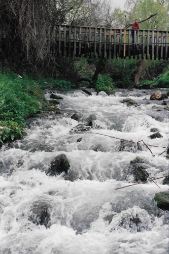
Even though it was starting to sprinkle, we wanted to see Espada Dam, so we drove down to the park that has been formed around it near the Mission San Francisco de la Espada about two or three miles away.
Espada Dam
|
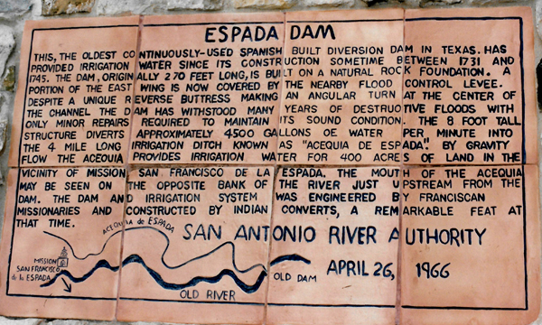
The initial survival of a new mission depended upon the planting and harvesting of crops. In south central Texas, intermittent rainfall and the need for a reliable water source made the design and installation of an acequia system a high priority. Irrigation was so important to Spanish colonial settlers that they measured cropland in suertes -the amount of land that could be watered in one day.
The use of acequias was originally brought to the arid regions of Spain by the Romans and the Moors. When Franciscans missionaries arrived in the desert Southwest they found the system worked well in the hot, dry environment. In some areas, like New Mexico, it blended in easily with the irrigation system already in use by the Puebloan Native Americans.
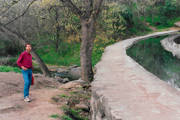
 Fred at Espada Dam Espada Dam is the oldest continuously-used dam along the river, and was quite an engineering feat for its time. Now, with the construction of a large levee system along the river, this dam is no longer needed, but it has been left as an example of the kind of construction used in the early 1700s. |
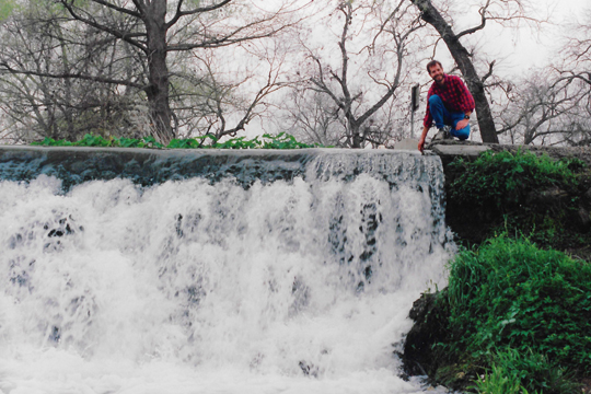 Me atop the Espada Dam Fred likes water features of all kinds, and I think that is why he wanted to stop here. |
In order to distribute water to the missions along the San Antonio River, Franciscan missionaries oversaw the construction of seven gravity-flow ditches, dams, and at least one aqueduct— a 15-mile network that irrigated approximately 3,500 acres of land. The acequia not only conducted potable water and irrigation, but also powered a mill.
|
|
|
The Espada Dam diverts water from the San Antonio River into the gravity driven acequia which flows parallel to the river until it crosses over Six Mile (Piedras) Creek on the Espada Aqueduct, shown in the picture at left. The Aqueduct, a Civil Engineering Landmark, lifts the acequia over the much stronger creek utilizing natural rock in the creek to help create a bulwark that directs water into both of the aqueducts arches to prevent the stronger creek from destroying the aqueduct itself. The acequia passes through the Espada farmlands that retain the pattern of their original laterals and returns to the San Antonio River south of the mission compound itself.
Just before we took our hike, it started to rain more heavily, so we took refuge under the arch supporting the viaduct as it crosses the creek, and waited about five minutes for the rain to stop. Once it did, we hiked about a quarter mile to a place where we could see more of the aqueduct.
We did not actually drive all the way down to Mission Espada. We thought we might save it for a future visit. The Mission has survived from its beginnings to the present day as a community center that still supports a Catholic parish and religious education, although a school originally opened by the Sisters of the Incarnate Word and Blessed Sacrament was closed in 1967. After we left the aqueduct across Piedras Creek, we got back in the truck and headed downtown, stopping to pick up some munchies on the way.
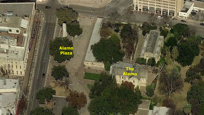
At the Alamo
|
The compound was one of the early Spanish missions in Texas, built for the education of area Native Americans after their conversion to Christianity. In 1793, the mission was secularized and then abandoned. Ten years later, it became a fortress housing a military unit, the Second Flying Company of San Carlos de Parras, who likely gave the mission the name Alamo. During the Texas Revolution, Mexican General Martin Perfecto de Cos surrendered the fort to the Texian Army in December 1835, following the Siege of Béxar. A relatively small number of Texian soldiers then occupied the compound for several months. They were soundly defeated at the Battle of the Alamo on March 6, 1836. When the Mexican army retreated from Texas several months later, they tore down many of the Alamo walls and burned some of the buildings.
For the next five years, the Alamo was periodically used to garrison soldiers, both Texian and Mexican, but was ultimately abandoned. In 1849, several years after Texas was annexed to the United States, the U.S. Army began renting the facility for use as a quartermaster's depot. The U.S. Army abandoned the mission in 1876 after nearby Fort Sam Houston was established. The Alamo chapel was sold to the state of Texas, which conducted occasional tours but made no effort to restore it. The remaining buildings were sold to a mercantile company which operated them as a wholesale grocery store.
After forming in 1892, the Daughters of the Republic of Texas (DRT) began trying to preserve the Alamo. In 1905, Adina Emilia De Zavala and Clara Driscoll successfully convinced the state legislature to purchase the remaining buildings and to name the DRT as the permanent custodian of the site. Over the next century, periodic attempts were made to transfer control of the Alamo from the DRT to an agency of the State of Texas (this being finally accomplished just before the mission, along with the four missions in the San Antonio Missions National Historical Park, was designated a UNESCO World Heritage site.
|
Everyone, at least every Texan, knows the story of the Alamo, and of all the famous figures in American frontier history who fought and died there, and probably everyone has seen one or more of the movies about the fort. It is quite something else to see it up close and for real, and I could understand the reverence that most native Texans have for it.
If you were to look behind me, you would see a busy city street and the downtown area of San Antonio, with its Riverwalk, its modern shops and its skyscrapers. But, look towards the Alamo and that's about all you can see. I don't know if this is by design (not having a bunch of skyscrapers actually behind the Alamo) or by chance, but it is a good thing, I think. I have nothing against progress, but everyone, from a native Texan to a programmer needs to understand and have an appreciation for that which is part of his history.
As of this year, I learned, the Alamo welcomes over three million visitors each year, making it one of the most popular historic sites in the United States. Visitors may tour the chapel, as well as the Long Barracks, which contains a small museum with paintings, weapons, and other artifacts from the era of the Texas Revolution. (We toured both, but without taking pictures inside.) Additional artifacts are displayed in another complex building, alongside a large diorama that recreates the compound as it existed in 1836. A large mural, known as the Wall of History, portrays the history of the Alamo complex from its mission days to modern times.
We walked through the building itself, and admired the memorials to the men who fought there (there were some women in the fort as well), and browsed among the artifacts that are preserved there. While not a native Texan, I was still impressed with the incredible sense of history that one gets from being there. I imagine that it is the same sense of history that my brother-in-law Bob must get when he tours a Civil War battlefield.
|
|
After walking around the Alamo and looking through the souvenirs (mostly tasteful) that were for sale (and whose proceeds keep the Alamo in repair since it is not a National Park, or anything) we decided to go down to the Riverwalk. We also made plans to go to the IMAX theater that they have in Riverfront Center, an enclosed mall adjacent to the River Walk.
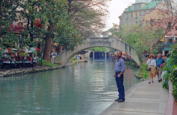
On the San Antonio River Walk
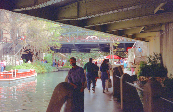
Now, in 1993, the River Walk is confined to the downtown area- although it is still many blocks long, with one side canal, just in that area. Fred and I will, as it turns out, visit San Antonio frequently in the future, and we will be witness to a huge expansion in what is, next to Fiesta, San Antonio's major tourist attraction. Down here, one level below the street, there are no cars- just the occasional river barge that carries tourists. Buildings along the River Walk typically have a regular entrance at street level as well as a separate entrance one level down on the River Walk itself. These lower levels are typically leased to restaurants and other tourist facilities. Hotels of course can advertise being on the River Walk, and office structures get a great deal of additional revenue from what had been simply their basements. Here are some of today's pictures:
|
|
I think one of the most interesting things about the Riverwalk is that you can't see it from street level. Unless you were specifically looking for it, you could drive your car all throughout the downtown area of San Antonio and never suspect that only one street below you is this entirely separate land of restaurants, shops and sightseeing boats. Oh, you would be crossing bridges and might conclude that there was water below, but there is little hint that the area has been turned into this spectacular attraction. Again, whether this is by design or by accident, I find it very interesting.
To get down here, one usually parks in one of the city lots, and then either walks through one of the hotels or shopping malls that has a Riverwalk access (there are signs to point you in the right direction) or you take one of the outside stairways beside most of the city street bridges down to it. Once down there, you can walk the entire length of the River Walk (a few miles) without having to come up to street level or cross a street at all.
|
|
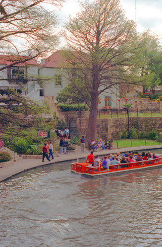
Where the Riverwalk is not crossed by a city street, there are foot bridges like the one in the background to allow the pedestrians to cross to the shops and such on the other side of the river. On the far side of the river in this picture is the Mexican restaurant where we ended up eating that evening.
When the weather turned more rainy, we went inside and went to the IMAX theater, where we saw one of the movies about flight that have been made with the IMAX process. The San Antonio River Walk an enormously successful attraction; both locals and tourists visit it in droves. It began just downtown, from the Alamo to Hemisfair Park. But in the years since this visit San Antonio has expanded the River Walk greatly, and you have a treat in store for you on those pages where Fred and I, along with a lot of folks you have yet to meet, visit San Antonio and walk the entire length of the expanded River Walk System (not all at once but in sections), which now goes from Brackenridge Park on the north all the way to Mission Espada- an amazing six miles north to south. You will also get to go with us on a river barge dinner cruise.
It was about time for Frank and Joe to arrive, so we went to the appointed meeting place at the Marriott and waited for them. We waited quite a while as they were about two hours late, but they finally showed up and we all went off to the Mexican restaurant that I pointed out earlier to have supper. Then we went off to the La Quinta to change and get ready to go out. During the day, Fred and I had moved from the Rodeway Inn, which turned out to be in very sad shape, to the newer, more modern La Quinta, where we got a very nice room for the four of us. We did go out to one of the local bars for a while, but we were back early.
You can use the links below to continue to another photo album page for our San Antonio trip, or return to the trip index, from which page you can continue backwards or forwards through the photo album.
|
March 20, 1993: Hemisfair and the Trip to Leakey |
|
March 18, 1993: A Day in Austin |
|
Return to the South Texas Trip Index |