|
July 1, 1994: Sunset Crater and the Grand Canyon |
|
Return to the Index for Our Western Trip |
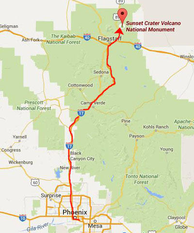
We are going to be able to do five days out West yet only use two days of vacation, since our last day out there will be July 4th, which both of us have free. Our first objective is to get out to a campground in the northern part of Arizona.
Getting to the Sunset Crater Volcano National Monument
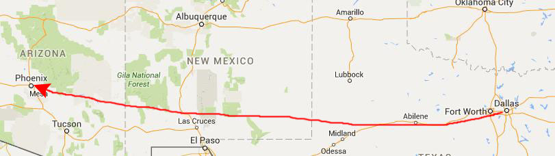 |
We arrived there about 9:30 local time (Arizona does not do daylight savings time, so there was a two-hour time difference instead of one hour.) We rented a Lumina from Alamo, piled the gear into it, and headed off north.
|
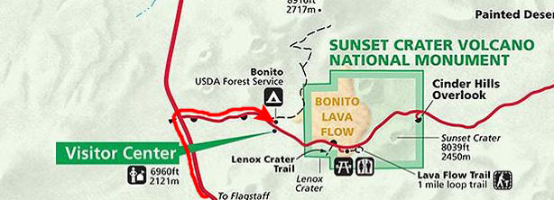 |
I had done some spadework early in the month by calling the campground hosts at Bonita and trying to find out how good a chance we had at getting a campsite. I talked three times with Anne, one of the hosts, and we concluded that to be on the safe side, Fred and I should drive right up from Phoenix, get a campsite as early in the day as we could, and then go sightseeing after that.
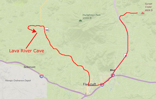
We got to the Bonita Campground just after noon, and were able to find a good campsite without any trouble. We checked in, paid our camping fee, and then set up the tent. The large bag I borrowed worked fine; I will undoubtedly buy one for ourselves. Fred has a new tent, and we found that setting it up can be tricky sometimes until you get used to it, but we had everything set up before too long. We planned to go first to a volcanic cave near Flagstaff, and then to Sidona. We drove back into Flagstaff where we had lunch at Wendy's and we stopped at a Baskin-Robbins (a new one for me), and then we went on to the lava cave.
Lava River Cave
|
We eventually found that Forest Service Road 245 dead-ended into Road 171, the next turn in our instructions and we headed to the left. But we missed the very small, hardly-marked dirt road off to the parking area for the cave. I think both of us were looking for something bigger than we found (bigger road, that is) and we missed the turnoff to the cave not twice but three times. We finally found it, though, when we spotted two cars parked off in the forest.
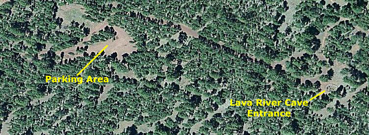
The parking area was basically just a clearing, and there was only one small sign pointing in the direction of the cave. We headed off that way but weren't absolutely sure we were on the right path until we met some folks returning from the cave.
|
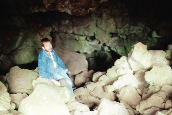
Lava River Cave is a lava tube cave in northern Arizona's Coconino National Forest. At approximately three-quarters of a mile long, it is the longest cave of this kind known in Arizona. The cave was discovered by some lumbermen in 1915. The cave has also historically been referred to as "Government Cave" due to its location on the eastern edge of Government Prairie and southeast of Government Peak. Today, Lava River Cave is freely accessible to the general public.
Geologists believe the cave was formed sometime between 650,000 and 700,000 years ago when molten lava erupted from a volcanic vent in nearby Hart Prairie. The top, sides and bottom of the flow cooled and solidified, while lava in the middle flowed out, leaving a hollow space to form the cave. Examples of both aa and pahoehoe basaltic lava can be seen in the cave.
|
The cave is actually in the Coconino National Forest, which occupies a large area north and west of Flagstaff. The cave is not like some others we have been in; there are no tours, no guides and no improvements. Just you and your flashlight. We met a couple of people coming out of the cave, and stopped to chat with them before going in.
The cave is mostly dry, but due to the temperature change, there is a lot of condensation on the walls, ceiling and floor near the entrance, which makes it slippery. Temperatures inside are around 40°F (5°C) during the summer, and it is not uncommon for some of the rocks to be covered with ice. The cave can range in height from 30 feet to only 2 to 3 feet. There are no light sources inside. It is recommended visitors have sturdy hiking boots, warm clothing, and multiple sources of light.
Litter and graffiti have been problems since the late 1960s. A major restoration effort was organized in May 1991, and we are the beneficiaries of that. Almost all the litter was packed out and much of the graffiti removed at that time. (We did notice a small sign saying that dogs should not be taken in the cave (for obvious reasons).
|
The cave formed within a few hours, after a brief volcanic eruption. In comparison to other geologic events, the cave formed in the briefest of moments. It appears today much as it did shortly after its formation. The cave is actually a lava tube, and is the longest cave of its kind in Arizona. Geologists believe that the cave was formed between 650,000 and 700,000 years ago, when molten lava erupted from a volcano near the present day site of Michelbach Ranch, which we passed through on the way up here. As the lava flowed, the top crusted over, but the lava continued to flow out of the tube, leaving the hollow tube we see today. Lumber men working for the Saginaw and Manestee Lumber Company discovered the cave in 1915, and people have been visiting it ever since. It is in remarkably pristine shape for a site that is not maintained and controlled. Perhaps the reason is that it is way, way off the beaten path.
We spent about an hour and a half inside the lava cave; it was very interesting, although much different than the lava tubes I was in when I visited Hawaii in years past.
Sedona, Arizona
|
We would have tried to camp here, but the campsites are usually all taken, Fred said. Also along this beautiful highway there were a number of turnouts for other hikes down into Oak Creek Canyon, but once again, we thought we should leave those for another trip out here (which we made some years later) and we continued on to Sedona.
It took us about an hour from the turnoff from Interstate 17 until we came into the town of Sedona from the northeast.
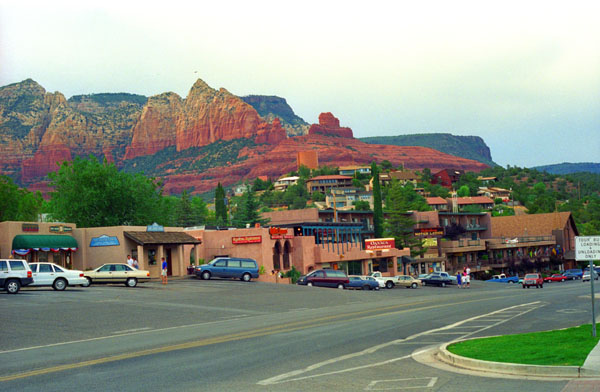
Sedona straddles the county line between Coconino and Yavapai counties in the northern Verde Valley region of Arizona. Its population is around ten thousand, although many of the residents are seasonal. Sedona's main attraction is its array of red sandstone formations. The formations appear to glow in brilliant orange and red when illuminated by the rising or setting sun (so we were here at an ideal time today). The red rocks form a popular backdrop for many activities, ranging from spiritual pursuits to the hundreds of hiking and mountain biking trails. Sedona was named after Sedona Schnebly (1877–1950), the wife of the city's first postmaster, who was celebrated for her hospitality and industriousness.
 |
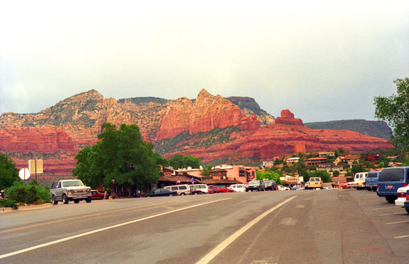 |
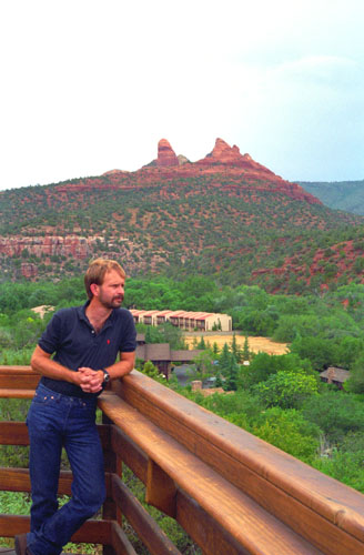
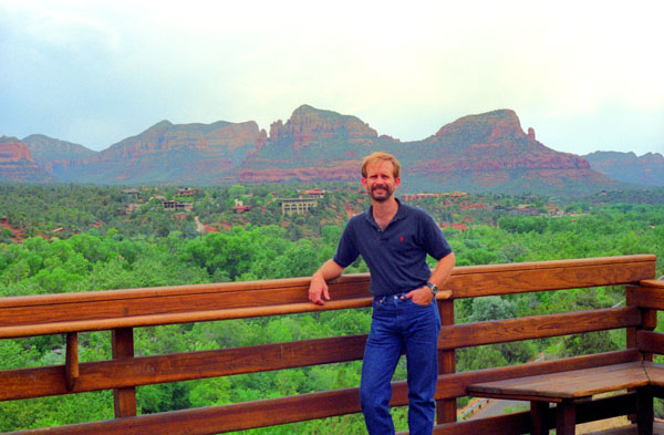
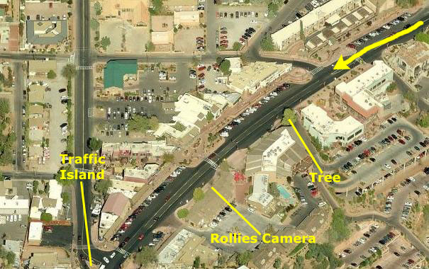
As soon as we came over a gentle hill and into town, the amazing views of the red rocks that surround Sedona came into view. We stopped the car pretty quickly and got out to take some pictures. Above, you can see an aerial view of downtown Sedona with some features marked on it on the left and on the right, the first picture that we took. The aerial view is, of course, recent, but you can see that little has changed in 20 years. You can even see the same tree on the southeast side of the street that appears at left in the photograph and which I have labeled on the aerial view. Look carefully at the photo, and you will see the sign for Rollies Camera Shop; it is still there, and I marked its location on the aerial view as well.
|
This looked like a really interesting place, so we parked the car so that we could walk around. At one end of the short but interesting main street in the older part of town was an overlook that offered excellent views of the countryside surrounding Sedona. There was a redwood deck that was cantilevered out over a small canyon, there were places to sit down and take in the great views of the beautiful red rocks, mesas and hills surrounding the town.
The first documented human presence in Sedona area dates to between 11,500 to 9000 B.C. (although it is interesting to note that this fact was not known when we visited this year; it would be next year when a Clovis projectile point was discovered that revealed the presence of Paleo-Indians. Around 9000 B.C., hunter-gatherers appeared in the Verde Valley, and they stayed for nine thousand years; they were gone by 300 A.D. (both conclusions partially based on an assortment of rock art left behind.
The Sinagua people entered the Verde Valley about 650, bringing their culture of art such as pottery, basketry and masonry. They left rock art, pueblos, and cliff dwellings, and abandoned the Verde Valley about 1400 A.D. (moving, researchers believe, to the Hopi mesas in Arizona and the Zuni and other pueblos in New Mexico. The Yavapai, nomadic hunter-gatherers, came from the west around 1300 A.D., and the Apache arrived a century later. Both tribes were forcibly removed from the Verde Valley in 1876, to the San Carlos Indian Reservation; many died on the forced march there. In 1900, about 200 Yavapai and Apache people returned to the Verde Valley and have since intermingled to become a single political entity- the Yavapai-Apache Nation.
The first Anglo settler, John J. Thompson, moved to Oak Creek Canyon in 1876; other settlers, farmers and ranchers, arrived soon after. Oak Creek Canyon was well known for its peach and apple orchards. In 1902, when the Sedona post office was established, there were 55 residents. In the mid-1950s, the first telephone directory listed 155 names. Some parts of the Sedona area were not electrified until the 1960s. Sedona began to develop as a tourist destination, vacation-home and retirement center in the 1950s. Most of the development we saw today was constructed in the 1980s
|
It is always a pleasure to get away from the big city and visit places like this, and we spent some time just walking around and going in and out of the galleries and shops before and after stopping at this overlook. I can only wish that Dallas was located in, or at least near, vistas like those around Sedona. Fred told me that there were a great many hiking opportunities around Sedona, and I expressed an interest in returning here (something we did in 2010).
Aside from its natural beauty, though, Sedona has other attractions not quite so, well, physical. Sedona has long occupied an honored place in the pantheon of the New Age movement- mostly because of the vortexes that are supposed to exist there. No, it’s not vortices. In Sedona the plural of vortex is usually vortexes. So what is a vortex, anyway? Well you see them in everyday life. The turbulent flow of water makes vortices. If you have ever seen a whirlpool in a river or watched water going down the drain in the bathtub and have witnessed the tornado like glassiness of spinning water, you have seen a vortex. A vortex is created from spiraling motion of air or liquid around a center of rotation. If you have ever witnessed a dust devil kick up in the desert, you have seen a vortex.
In Sedona vortexes are created, not by wind or water, but from spiraling spiritual energy. The vortexes of Sedona are named because they are believed to be spiritual locations where the energy is right to facilitate prayer, mediation and healing. Vortex sites are believed to be locations having energy flow that exists on multiple dimensions. The energy of the vortexes interacts with a person’s inner self. It is not easily explained. Obviously it must be experienced.
|
This one mile stretch of Highway 89A that goes through Sidona and on down to Prescott is lined with small shops and galleries. Like Santa Fe, Sidona has a number of artists who sell their works in these shops. I am not such a connoisseur that I can tell good art from everything else, but I found much to admire in the shops that we went into. Fred, of course, is always on the lookout for anything with a buffalo motif, and he found a few things that he liked.
One buffalo sculpture made out of stone caught his eye, and he was debating whether or not to add it to his collection, when I realized that I didn't yet have a gift for his birthday, about a month off (August 6), so I purchased it for him when he put it down to look at something else. Unfortunately, he decided to get it, and I had to tell him right then that I had already bought it for him.
Anyway, back to the vortexes. In 1987, Sedona‘s reputation as a spiritual center got quite a boost. Many journeyed to Sedona during the time of the highly anticipated "Harmonic Convergence". On the weekend of August 16th and 17th, 1987, the great "Harmonic Convergence" was supposed to take place - at least, that is what José Arguelles, a famous New Age "mystic" told people. A great many believed him - not simply prominent leaders of the New Age movement like Shirley MacLaine, but also millions and millions of adherents.
What was the nature of this convergence? Well, according to Arguelles, at this time the Earth would start slipping out of its "time beam" and risk spinning off into space - only by the concerted, psychic efforts of the human race would it remain where it was supposed to be. This time would see a great increase in the experience of deja vu and UFO sightings. However, if enough people would simply gather at sacred places around the globe and concentrate enough, the New Age would begin, the Earth would remain safe and a new era of harmony and love would be inaugurated.
Well, they gathered and presumably they concentrated and, sure enough, the earth stayed right where it was supposed to be.
A film titled Sedona was released in 2012. It was the first feature film to be shot entirely in Sedona since the 1970s, when the heyday of Hollywood filmmaking in the area ended. The cast includes Frances Fisher, Seth Peterson, Barry Corbin, Christopher Atkins, Lin Shaye and Beth Grant.
I bought a box of Roadkill Helper in a little gift shop (which I still have). By the time we had wandered around for a while, the shops were closing. Fred had gotten a recommendation for dinner, so we ate at a local restaurant. Fred had a steak and I had a very good Mexican dish. The restaurant was very upscale, but we enjoyed it a great deal. We did our grocery shopping at the local supermarket, and then headed back to Flagstaff and the campground.
You can use the links below to continue to another photo album page.
|
July 1, 1994: Sunset Crater and the Grand Canyon |
|
Return to the Index for Our Western Trip |