|
October 29, 1994: Hiking at Sierra Blanca/Three Rivers Petroglyphs |
|
October 27, 1994: Guadalupe Mountains National Park |
|
Return to the Index for Our Western Trip |
We got up early the next morning, struck camp, and set off for Carlsbad Caverns. As for myself, I had not been inside the Caverns since 1968, during the Summer when I drove across country to visit Peter Guerrant in California. At that time, I spent the better part of a day wandering around the Cavern trails.
 |
Carlsbad Caverns National Park is located in the Guadalupe Mountains, about ten miles west of White City, New Mexico, which was itself about twenty miles northwest of our campsite, so it took us the better part of an hour to get there. The primary attraction of the park is, of course, the show cave, Carlsbad Cavern. We entered the cave via the natural entrance, and came back up the elevator. The park has two entries on the National Register of Historic Places: The Caverns Historic District and the Rattlesnake Springs Historic District. Approximately two thirds of the park has been set aside as a wilderness area, helping to ensure no future changes will be made to the habitat. Carlsbad Cavern includes a large cave chamber, the Big Room, a natural limestone chamber that is almost 4,000 feet long, 625 feet wide, and 255 feet high at the highest point. It is the fifth largest chamber in North America and the twenty-eighth largest in the world.
|
When we got to the Visitor Center, we paid our admission and went right on out to the entrance to the Cave. Although the tours are not guided, entrance to the Cave is in groups, so that each group can get a short talk on the history of the Cave, safety, and so on. Neither Fred nor I like to tour in groups very much, so as soon as the familiarization talk was over, we headed off down the trail into the Cave.
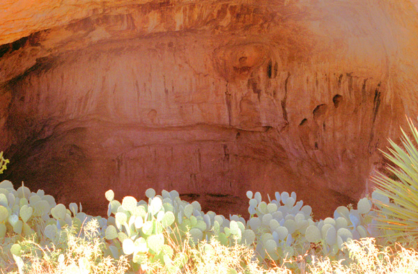
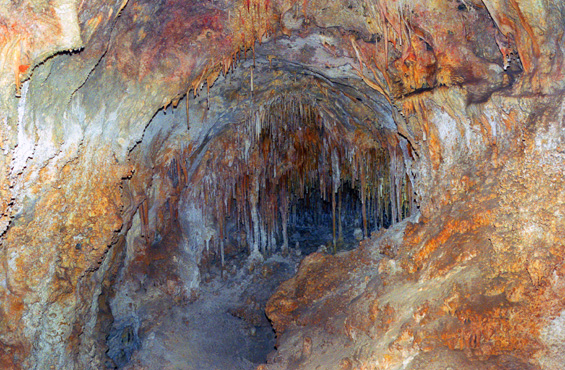
At the beginning, you move down a long series of switchbacks at the Bat Flight Amphitheater at the Cave's natural entrance. At left is a view looking down into the amphitheater and the natural cave entrance.
An estimated 250 million years ago, the area surrounding Carlsbad Caverns National Park served as the coastline for an inland sea. Present in the sea was a plethora of marine life, whose remains formed a reef. Unlike modern reef growths, the Permian reef contained bryozoans, sponges, and other microorganisms. After the Permian Period, most of the water evaporated and the reef was buried by evaporites and other sediments. Tectonic movement occurred during the late Cenozoic, uplifting the reef above ground. Susceptible to erosion, water sculpted the Guadalupe Mountain region into its present-day state.
|
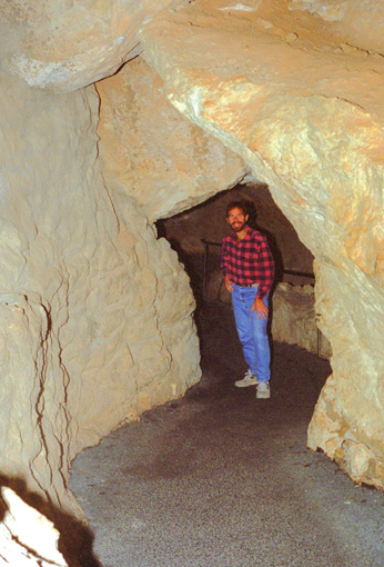
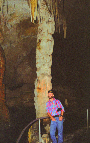
This area is called Bat Cave, as most of the bats that fly in and out of the cave come through here and roost off to the sides of the cave. Taking cave shots is tricky; usually you are either too close to or too far away from the object you are photographing for the flash to work properly. This picture that Fred took was very dark, and even the tools available to me today couldn't lighten it enough to bring out much of the background behind me.
I did have some memories of the time I'd been in the caverns just over 25 years ago. The trails seemed to have been repaved and rerouted in spots, although my memory could easily be faulty. We saw some bats, but not many, since they winter in Mexico and had mostly already departed. I guess the ones we saw were a local variety, as I imagine the main group would travel together when they migrate.
The first part of our tour was on our own, from the cave entrance down through the main corridor to the Big Room. There, we joined a guided tour to some of the rooms you can't go in unless you are on one. So we did some backtracking today, which makes a more linear exposition a bit tricky. So, I will do things a bit differently.
|
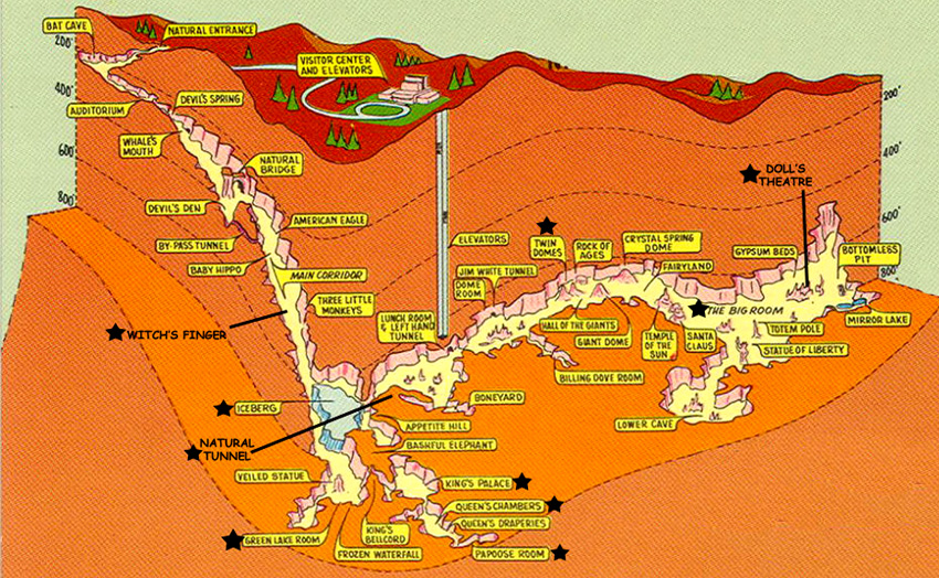
We did visit most of the areas labeled on the map, but didn't take photos everywhere. (I might note that if we were visiting the cave today, with our digital cameras, where photographs literally cost zilch, we would have taken lots more pictures than we did. But we were a bit concerned that our flash attachments would illuminate enough of the far-off formations to make the pictures interesting- at least not without setting up a tripod and doing a time exposure, something that was way too time-consuming.)
So what I want to do is just show you some of the pictures we took, with a bit of explanation as to where each one was taken, and you can locate these pictures on the diagram. I have added some labels for rooms or formations that weren't marked on the diagram.
So with that in mind, and with the graphic to help, here are the pictures we took today that turned out well enough to include in the photo album.
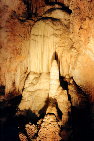
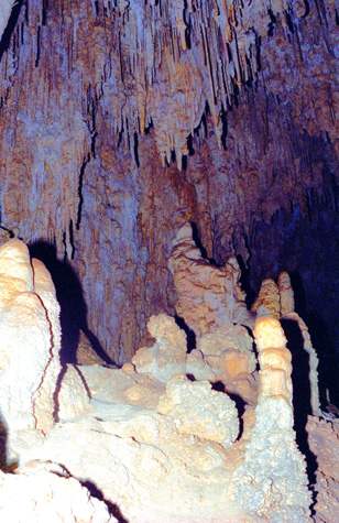
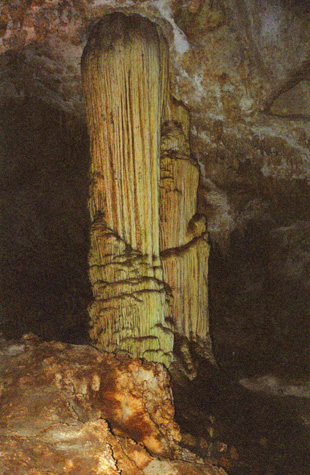
 The Witch's Finger |
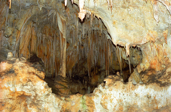
(Picture at left) It was hard to remember the names of the various formations that we saw; this one, on the way down the Main Corridor, was called the "Witch's Finger". The Main Corridor leads from Bat Cave down into the scenic rooms of the Cave. After a while, I realized that with so many formations, it was going to be impossible to get pictures of them all. The pictures would also be repetitive, and so we both kind of decided to just try to hit the high points.
(Picture at right)
|
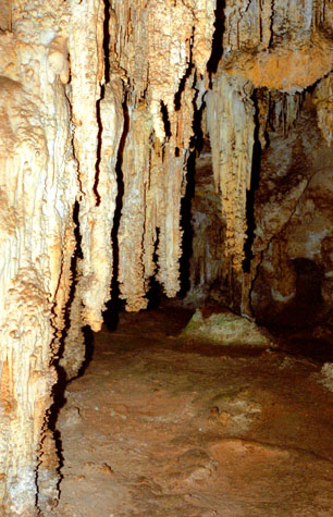
 Around Iceberg Rock |
The Main Corridor was a neat walk, gently sloping downhill as we walked. At the lower end we came to Iceberg Rock.
|
 |
The Boneyard is an undecorated area that may resemble what Carlsbad Cavern looked like during its early years of formation. There weren't many times during out tour that I got a bit claustrophobic, but this was one of them. As I was going through this tunnel, I could feel the weight of all that limestone above my head.
From the Main Corridor, there is an entrance into the smaller scenic rooms, but there has been so much damage done there, that they are closed off and accessible only on a guided tour that starts from the underground lunchroom staging area. There is a shortcut that bypasses them and sends you on down to the Big Room, where you can sign up for that tour and return. We decided to do that. In the lunchroom area, we grouped with the guided tour and then started off to see the scenic rooms that aren't accessible unless you are on a tour.
|
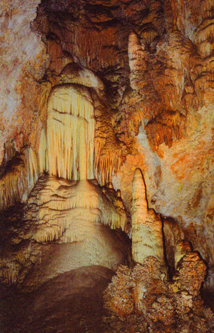
Below are some of the delicate formations in a room called the Queen's Chamber, the second room we visited on our guided tour.
 |
While a young boy, Jim White explored the cavern with his homemade wire ladder. When he grew older, there was considerable doubt as to whether the caves actually existed. He named many of the rooms, including the Big Room, New Mexico Room, Kings Palace, Queens Chamber, Papoose Room, and Green Lake Room. He also named many of the cave's more prominent formations, such as the Totem Pole, Witch's Finger, Giant Dome, Bottomless Pit, Fairyland, Iceberg Rock, Temple of the Sun, and Rock of Ages.
 In the Queen's Chamber |
(Picture at left) The guided tour winds it way through this large room, and we paused a number of times for short talks on various aspects of the Cave.
(Picture at right)
|
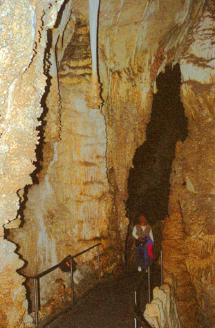
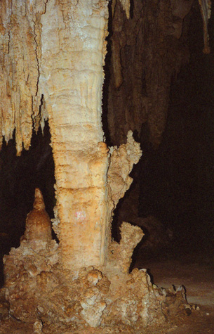 In the King's Palace |
Carlsbad Caverns National Park is situated in a bed of limestone above groundwater level. During cavern development, it was within the groundwater zone. Deep below the limestones are petroleum reserves. At a time near the end of the Cenozoic, hydrogen sulfide began to seep upwards from the petroleum into the groundwater. The combination of hydrogen sulfide and oxygen from the water formed sulfuric acid. The sulfuric acid then continued upward, aggressively dissolving the limestone deposits to form caverns. The presence of gypsum within the cave is a confirmation of the occurrence of this process, as it is a byproduct of the reaction between sulfuric acid and limestone.
 In the King's Palace |
(Picture at left) All along the sides of this room were intricate and beautiful formations like these. It was in this room that the guides sat us down and turned off the lights so we could experience the total darkness of the Cave. That is always interesting, and we did the same thing two years ago when we toured New Cave not far from here.
(Picture at right)
|
 In the King's Palace |
Once the acidic groundwater drained from the caverns, speleothems began to be deposited within the cavern. Erosion above ground created the natural entrance to the Carlsbad Caverns within the last million years. Exposure to the surface has allowed for the influx of air into the cavern. Rainwater and snowmelt percolating downward into the ground pick up carbon dioxide; once this water reaches a cavern ceiling, it precipitates and evaporates, leaving behind a small calcium carbonate deposit. Growths from the roof downward formed through this process are known as stalactites.
 |
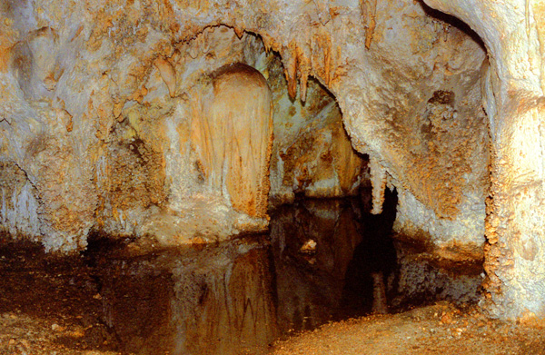
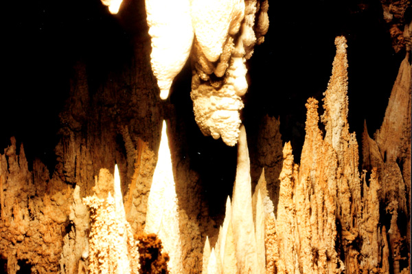
(Pictures at left and right) These are the Twin Domes in the Big Room in Carlsbad Caverns
As the trail winds around the side of the room, there are these two formations standing out by themselves. I wish the flash had penetrated the darkness more.
|
 |
Additionally, water on the floor of the caverns can contain carbonic acid and generate mineral deposits by evaporation. Growths from the floor upward through this process are known as stalagmites. Different formations of speleothems include columns, soda straws, draperies, helictites, and popcorn. Changes in the ambient air temperature and rainfall affect the rate of growth of speleothems, as higher temperatures increase carbon dioxide production rates within the overlying soil. Color of speleothems is determined by the trace constituents in the minerals of the formation.
 In the King's Palace |
(Picture at left) I suppose this is one of the formations that gives this room its name, for it looks very much like a throne.
(Picture at right)
|
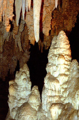
 In the Big Room |
Until 1932, visitors to the cavern had to walk down a switch back ramp-sidewalk that took them 750 feet below the surface. The walk back up was tiring for a lot of visitors. In 1932 the national park opened up a large visitor center building that contained two elevators that would take visitors to the caverns below. The new center included a cafeteria, waiting room, museum and first aid area.
|
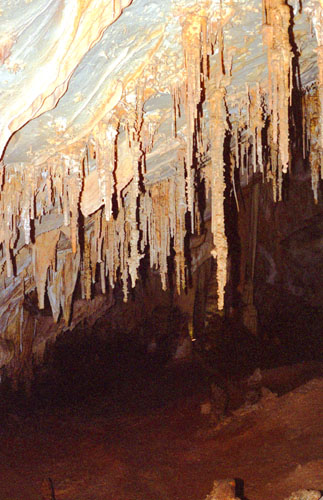
The picture at left shows the pool in the Green Lake Room. This room is a wonderland of thousands of delicate stalactites, marble-like flowstone, and 8-foot deep Green Lake.
This brought us to the end of the guided portion of the tour, so we went back to the lunchroom and set off to explore the Big Room. The tour around this room is well over a mile long, and took us about an hour and a half.
In 1923, President Calvin Coolidge signed a proclamation establishing Carlsbad Cave National Monument, and a year later he issued an executive order for a possible national park or monument at the site. A supplemental 1928 executive order was issued reserving additional land for the possible monument or park. Finally, in 1930, an act of the United States Congress established Carlsbad Caverns National Park. (An additional area, the Carlsbad Caverns Wilderness, was established by Congress during the Carter administration.)
Here are the final two pictures we took inside Carlsbad Caverns:
 The Dolls' House in the Big Room Along a side corridor off the Big Room are a series of formations like this one, that look like miniature representations of the large cave. The pipes are very narrow and look very delicate. There was also a good deal more color than this picture indicates. |
 The Dolls' House in the Big Room You can see the very narrow pipes, again, and also some curtain stone that forms a column. There was a lot of color here, mostly pale pastels and a distinct reddish tinge on many of the pipes. |
We continued around the Big Room, passing Mirror Lake, which didn't look as if it would take a good picture, and the Bottomless Pit (which is actually only 150 feet deep). It took us over an hour to circle the room, and then we took the elevator back to the surface. The Caverns were both smaller than I remembered them, but also better kept, it seems, although memory can be very faulty over 25 years.
|
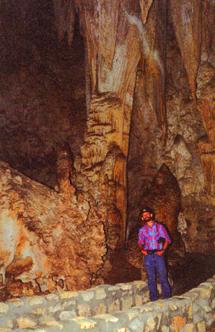
Back on the surface, we spent some time looking at some of the exhibits, one of the most interesting of Lecheguilla Cave, a relatively new discovery that is closed to all but researchers. There were beautiful pictures of the formations and lakes in that cave, which is some distance from here.
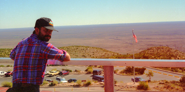
We went up on the roof of the Visitor Center to get a view to the east, and that is where I took the picture of Fred at right. The Honda is just behind Fred down in the parking area.
We had a bit of lunch at the car, and then headed back out the park road towards Carlsbad, NM.
|
We got back down to US Highway 62/180, and we headed north. We went through Carlsbad and continued north on US Highway 285, reaching Artesia in early afternoon. We continued on north to Roswell, New Mexico. There turned out to be a Baskin-Robbins, so we stopped briefly, and then headed west on US Highway 70/380 towards Ruidoso.
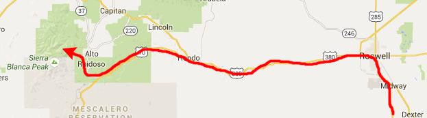 |
As we got close to Ruidoso, we had to make a decision as to where we would camp for the night. We settled on the Bonita Lake campground, near 12,000-foot Sierra Blanca. We drove through Ruidoso in late afternoon. It was a picturesque town, although it has become quite the artsy community, something like Santa Fe but without quite the cachet.
|
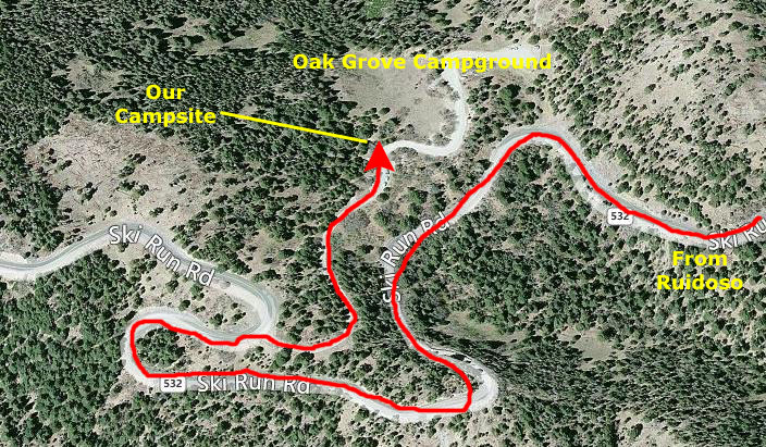
We got there early in the evening, and were one of only two cars there (it being late in the season and close to the time that the campground closes). The road down to the campsites was rocky and steep, and I found myself wishing that Fred had brought his truck, but it was OK once I got the hang of it. I'd been having a slow leak in my left front tire, but it held up OK.
We pitched our tent, and the two people next to us came over to chat. As it turned out, they were from Belgium, and were touring the United States. They had flown to Florida and rented a car, and had driven over 10,000 in the past month. They had done all the Florida things, and had also seen just about every National Park in the Western states as well. They were now on the return swing back across the Southern states to Florida. Fred gave them some good advice on getting to Big Bend, and even gave them one of his travel books to guide them. They seemed like really nice people.
Fred cooked another meal, and we spent some time walking around looking at the stars, which were extremely brilliant at this altitude (about 7000 feet). We even saw some meteors coming down. We both had a good night's sleep.
You can use the links below to continue to another photo album page.
|
October 29, 1994: Hiking at Sierra Blanca/Three Rivers Petroglyphs |
|
October 27, 1994: Guadalupe Mountains National Park |
|
Return to the Index for Our Western Trip |