|
October 23-28, 1996: A Camping Trip to Big Bend National Park |
|
August 3, 1996: Fred's Birthday Party |
|
Return to the Index for 1996 |
Transition Note
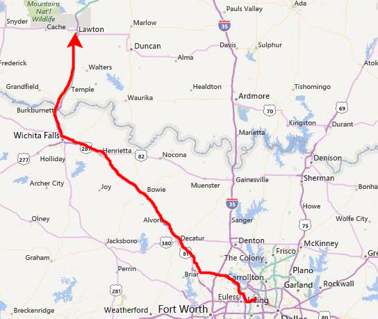
On the 5th of October, Fred, Mike Racke, Mike’s friend Brooks McBryde and I took a weekend trip to the Wichita Mountains.
Getting to the Wichita Mountains
|
But from Mike's house in Irving, we worked our way up to Texas Highway 114 west to its intersection with US Highway 287 and from there right on into Wichita Falls.
From there, it's an easy trip up Interstate 44 to Lawton.
When we got to Lawton, we checked in to a motel just east of the expressway and then headed up to the Wichita Mountains National Wildlife Refuge.
|
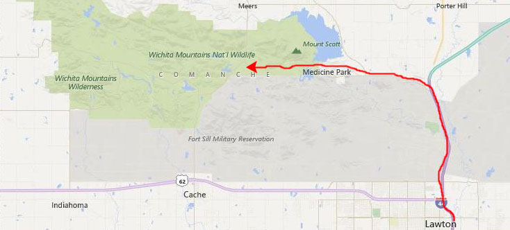
To get to the Refuge, you take I-44 north through Fort Sill and then, once you leave the military reservation you take Oklahoma Highway 49 to the west towards the town of Medicine Park. Just past that town you reach the boundary for the Refuge, although the actual visitor center (a small affair) is some miles into the park past Mt. Scott.
The Wichita Mountains National Wildlife Refuge
We did quite a few things on our two days here in the Refuge, and it might be helpful to show you a diagram of the Refuge with some of the things we did marked on it:
 |
We didn't take a great many pictures this weekend, so what I'll do is just have a little section for each of the stops, not worrying much about which day it was- today or Sunday.
The Wichita Mountains Refuge Buffalo Herd
|
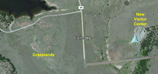
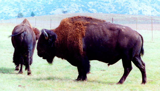
The Wichita Mountains Wildlife Refuge was important in saving the American buffalo from extinction. In 1907 the American Bison Society transported 15 buffalo, six bulls and nine cows, from the New York Zoological Park to the refuge. On arrival, the Comanche leader Quanah Parker and a host of other Indians and Whites turned out to welcome the buffalo. At that time, buffalo had been extinct on the southern Great Plains for 30 years.
The herd wanders throughout the Refuge, but fortunately one of the places they can often be found is right in the middle of the Refuge, on the grasslands west and north of the new visitor center. You can see it in the aerial view above, right, but keep in mind that the aerial view is from 2014; the new center won't be constructed for some years yet.
Since they were brought here, the herd here in the Wichitas has grown slowly, and today numbers about 600 on the refuge. In fall, buffalo in excess of the carrying capacity of the refuge are rounded up and sold. Visitors usually only see twenty or thirty animals at a time; the herd is not one big mass. Sometimes, like today, there may be only a few buffalo in these easily accessible grassland areas.
|
 |
Hiking Along the Narrows Trail
|
From a parking area, you can walk either along the rim of the canyon to the lake, or you can get down into the canyon itself, and walk or climb up along the watercourse to the lake. We did a bit of both.
We left Mike's truck in the parking area, and began the hike which first took us through a wooded area and some open grassland that led over and up to the rim of the small canyon.
|
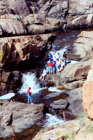
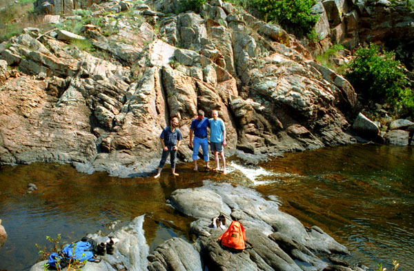
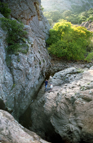
But after a short ways, the lake comes to an end and the canyon turns into a rocky affair with the small stream running down and over the rocks at the bottom. Here it is easy to hike along, and the first chance I got I scrambled down the hillside to the bottom and walked along there, the the other guys up above me. Then we came to the first of a couple of very nice waterfalls. Before the other guys came down into the canyon, Fred took the picture at right of me down by the waterfall.
I said that this was a popular area for casual hikers, and you can see a group of them sitting on the ledge of the waterfall above me. There are lots of little falls along the way up, which is a bit steeper than this shot, which Fred took from the top of the canyon, would indicate.
After taking that picture, Fred, Brooks and Mike came down into the canyon to join me.
|
There was a section here at the Narrows where the route up the canyon was easy, and always took you right along the water. As I said, there were lots of little waterfalls all the way up to Lost Lake. Being down here in the canyon was certainly a lot more fun that being up on the cliff- where it was a lot warmer.
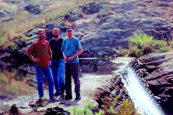
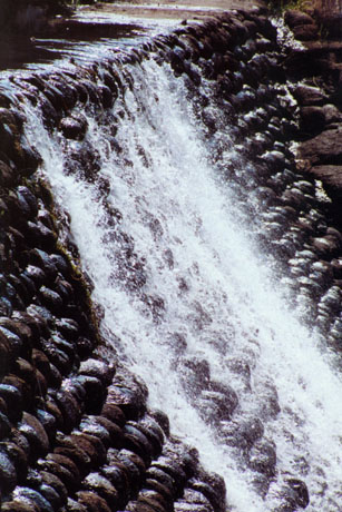
About an hour after we began our hike, we came out on top of the canyon to Lost Lake (more like Lost Pond). Here, we found a small rock and cement dam that held the pond back. As you can see in the closeup, the dam is made of rows of small rocks which were then cemented together:
 |
 |
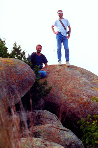
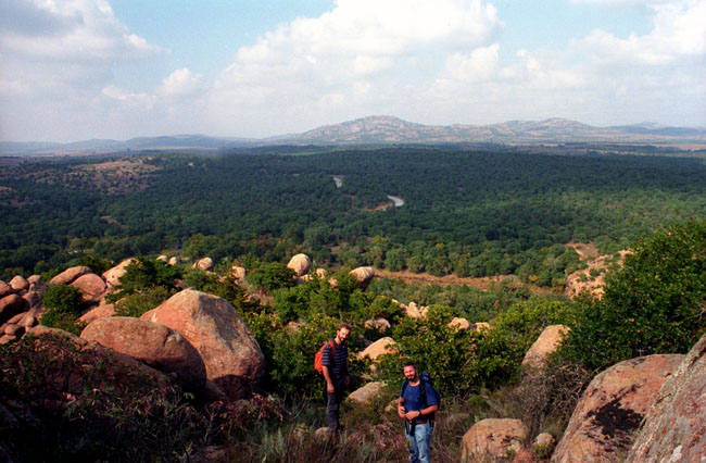
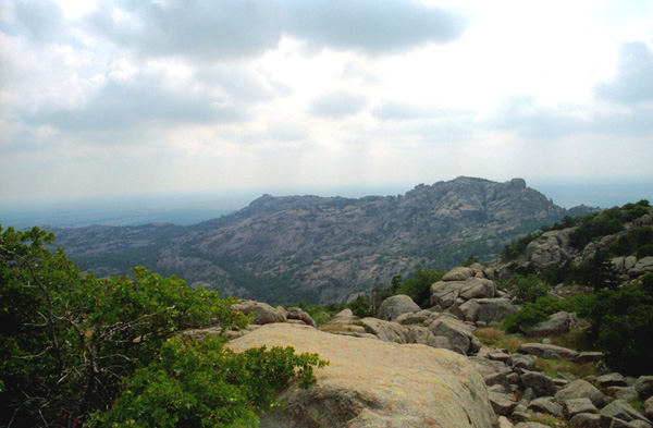
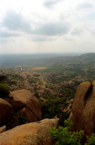
On Boulder Mountain
|
The views from the top were good, but as you can see, the weather was deteriorating (this was pretty late in the day on Saturday anyway):
 |
This was about all the hiking we did on Saturday. We did some more driving around, and then went back to the motel for a nice dinner and a relaxing evening.
The Prairie Dog Town
|
He was a nice guy, but quiet and very reserved. Fred likes to ask a lot of questions, but Brooks didn’t seem ready to answer many of them. Mike has told us that Brooks can be something of an oddity at times, sometimes being out of touch for long stretches of time. But we certainly enjoyed his company, and perhaps we will have an opportunity to see him again.
Anyway, as far as the prairie dog town was concerned, it was fun to watch the little animals chatter away and go in and out of their little dens (which are all connected underground, we are told). Fred used his telephoto lens to get a picture of a prairie dog up close and personal.
Elk Mountain
The hike is about a mile up and back, and it can be steep in places, but it was an easy hike, and a little cooler since it was cloudy. Here are a couple of the pictures we took on Elk Mountain:
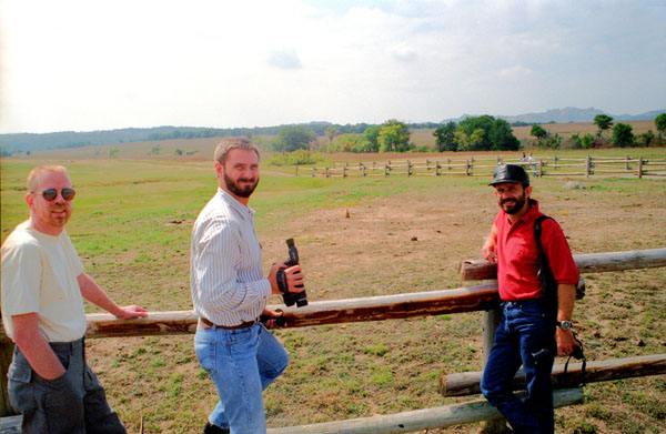
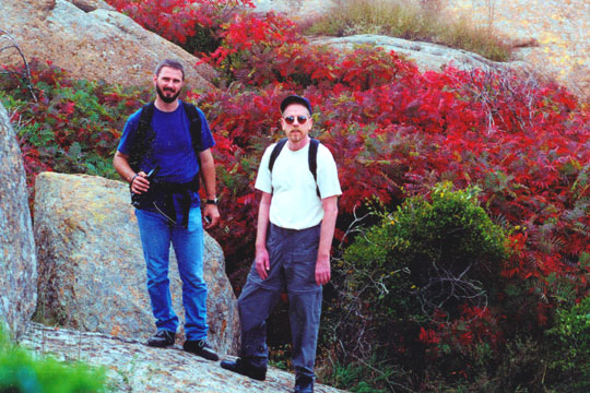 Fred and I always like hiking around here, as there is enough to keep things interesting- lots of boulders, cliffs, water features and the like. This was a particularly nice time of year for the vegetation, too. We have done this hike before, but it was a first for Mike and Brooks. |
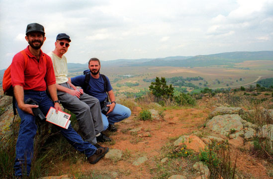 Here areFred, Brooks and Mike atop Elk Mountain. As you can see here, the terrain is really not very precipitous, and this makes the hikes easy even for families. So you get exercise and scenery without any danger at all. The buffalo herd is down in the valley to the right. |
Wandering around on top of Elk Mountain is neat; since you are on a kind of broad mesa, you can always tell when you come to the edge, for the land will slope steeply down, and you know enough to go back and find the actual trail. Here are a couple of the pictures we took atop Elk Mountain:
 Atop Elk Mountain |
(Picture at left) From the top of Elk Mountain, the views were tremendous. Although the area at the top of the mountain is not large enough to get lost, it is large enough to get out of sight of others. Occasionally, we had to call out loudly to find each other again.
(Picture at right)
|
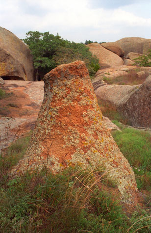 A Petrified Tree? |
The day wasn’t actually all that warm, but Fred wanted me to take this picture of him while we were on the top of Elk Mountain. Note the vegetation- particularly the prickly pear. Before we descended from Elk Mountain, Fred gathered all four of us together, set up the tripod and took this shot with his panoramic camera:
 |
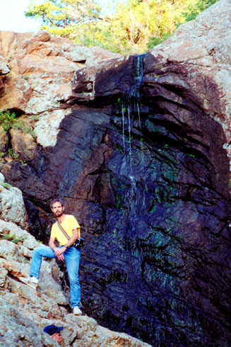
Post Oak Falls
|
Even though this waterfall is spring-fed, at this time of the year there is only a small amount of water going over, as we are usually coming off of a dry summer and the fall rains have not yet arrived. As you can see, climbing up to the top of the falls wasn’t very hard. Brooks’ head is poking up from the bottom of the cliff below me.
We took a couple of other pictures on this short hike, and you can see them below. One of them shows Brooks and Mike far below me, as I have hiked up almost to the top of the falls. The other, showing me at the top, will give you a good idea of how small this particular waterfall actually is. Barely enough to keep the rocks wet.
 |
 |
I could have gone on up to the top of the hill in front of me, but there were some other stops we wanted to make today.
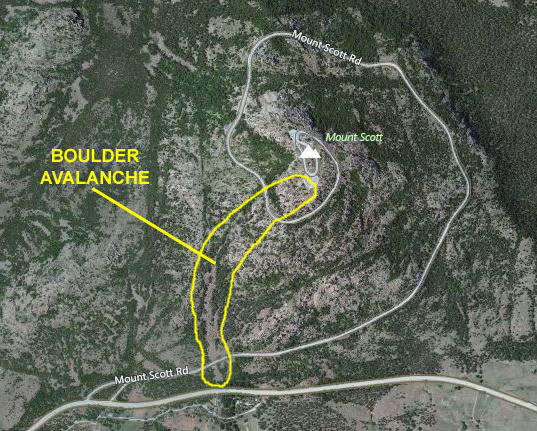
Mt. Scott and the Boulder Avalanche
|
The avalanche is an extremely interesting feature. From the bottom it looks as if someone emptied out a gargantuan container of boulders (some of them would only fit into a cube twenty feet on a side) near the top of the mountain so that they cascaded all the way down to the base. The boulders are of varying sizes and shapes, and one can imagine them cascading down the mountainside, finding the path of least resistance to the bottom. Once the flow had stopped, then the boulders would be pretty stable, wedged in and around each other. Only the very smallest ones might still rock back and forth.
The avalanche may well have followed the course of a small stream flowing down from the top of the mountain; as you climb up, you can sometimes hear water way beneath your feet. Boulder-hopping up and down Mt. Scott is one of our favorite things to do; this will be the second or third time we've been here and done this. Hopping from one to another requires a bit of care, but is not particularly dangerous (although people have lost their footing and fallen into spaces between the boulders).
|
The boulder field heads straight up for quite a ways, and then curves around to the east to continue all the way to the top. At two points, it crosses the spiral road. It takes about ninety minutes to get to the top, and perhaps a little more to get down (since hopping DOWN onto boulders has to be done a bit more carefully so your forward momentum doesn't cause you to pitch forward and go further than you intended).
Mike and Brooks took the truck up the roadway to the top, and Fred and I did our usual bouldering to get to the top. It’s always fun for me; this being my second or third time to do it. When we got to the top and rejoined Mike and Brooks, we all enjoyed the views, and I asked Fred and Mike to go down from the parking area just a bit so I could take the picture at right.
If you would like to see other pictures from the boulder avalanche, you can visit some of the other pages in my photo album (since we have been here so many times). You might want to find an album page from 2004 or later, when I had a digital camera small enough to fit securely in my pocket.
In late afternoon, we piled into the truck and headed off for home, eating dinner when we got back to Irving. It was a fun weekend, and we enjoyed meeting Brooks. We exchanged email addresses and planned to stay in touch.
You can use the links below to continue to another photo album page.
|
October 23-28, 1996: A Camping Trip to Big Bend National Park |
|
August 3, 1996: Fred's Birthday Party |
|
Return to the Index for 1996 |