|
October 31 - November 2, 1998: My Sister Judy Visits Dallas |
|
September 19, 1998: Jeffie and Her Horse |
|
Return to the Index for 1998 |
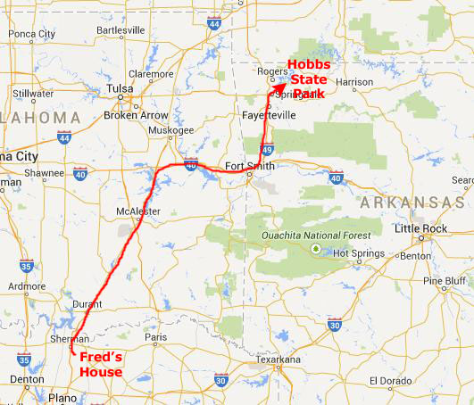
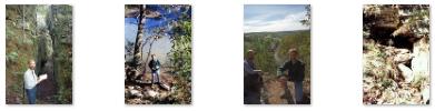
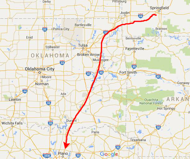
For our Fall trip this year, we are going to combine a couple of Fred's vacation days with a weekend and make a trip over to Arkansas and Missouri and just hit some state parks and points of interest we haven't seen before. I was up at Fred's house early on Thursday morning, October 22nd and once we had packed his truck we headed off north to our first stop- Hobbs State Park.
Hobbs State Park Arkansas
|
|
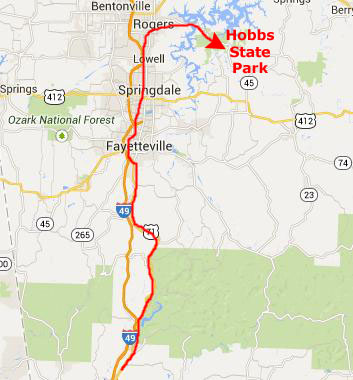
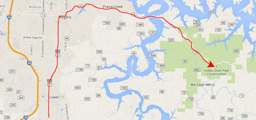
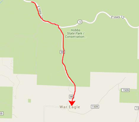
We took highway 71 all the way to Rogers, where we saw our first signs for the state park, and we turned east following them.
|
Arkansas's largest state park in land area, Hobbs State Park-Conservation Area (HSPCA) covers a 12,056-acre tract of diverse Ozark landscape along the southern shore of 28,370-acre Beaver Lake. Twenty-two of the park’s 60 miles of border stretch along the shores of Beaver Lake. The park lies between Beaver Lake to the north and War Eagle Creek to the south with acreage stretching across a part of Benton County southeast of Beaver Lake and extending into Madison and Carroll counties.
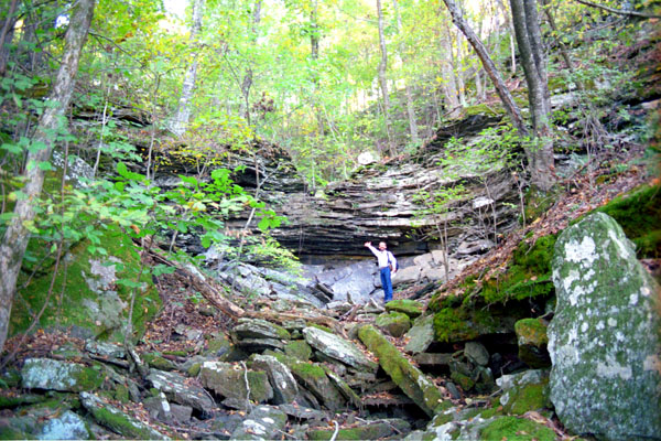
This park's landscape consists of plateaus, ridges, valleys, and streams featuring an upland forest of oak, hickory and pine. Many water features including disappearing streams, springs and seeps have carved the many hollows in this fragile limestone landscape and created cave-related features including numerous sinkholes.
|
|
While we didn't see any large wildlife while we were on the trail this morning, the sign at the trailhead said that wild turkey, whitetail deer and other wildlife have been commonly seen along the trail. It was a neat hike, and we got back to the car about one in the afternoon.
War Eagle Mill
 |
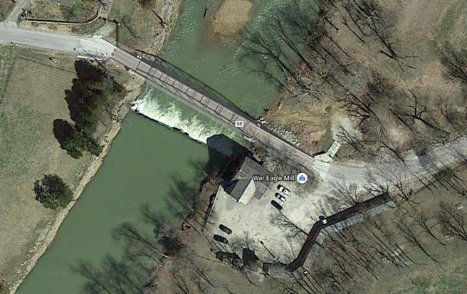 |
The history of War Eagle Mill begins with the story of a tenacious pioneer couple, Sylvanus and Catherine Blackburn, who understood the importance of fresh, natural food in the lives of families as far back as 1832 when the first Mill was built. Sylvanus was 16 years old when he married Catherine, and the young couple lived on his parents’ farm in Tennessee for a year but then decided it was time to find a place of their own. Sylvanus left Catherine with his folks and headed west. He didn’t stop until he came upon a lush valley next to the War Eagle Creek in Arkansas. Sylvanus had found the most beautiful setting for their new home and immediately sent for Catherine so they could begin their life in the War Eagle Valley. The first thing Sylvanus and Catherine did was build a house using wood from the surrounding forest. It sat on top of the little hill next to the Creek, and was so well built that it is still in use today.
|
In 1848, a flood destroyed the mill, but as soon as the waters receded, Sylvanus and Catherine rebuilt it- expanding it to mill lumber as well as grain. As the population of the valley rose, the Blackburns' business prospered. Good thing, since by now the couple had nine children!
The mill fell casualty to a different disaster ten years later- the Civil War. The boundary between slave and free was only a few miles to the north, and the War Eagle Valley became a focal point in the war. The Blackburns' five sons enlisted in the Confederate Army, and Sylvanus and Catherine took the rest of their children to Texas to ride out the conflict. It would be nearly four years before any of them would return. In 1862, the Union Army moved into northern Arkansas and the War Eagle Valley, and used the Mill to grind grain for food. The Confederate Army pushed them to Pea Ridge, but a Confederate general ordered the mill burned to prevent it from again being used by the Union. Chaos ensued after the horrific battle of Pea Ridge, and with crops destroyed and the Mill in ashes, food shortages forced many residents to leave.
Sylvanus and his family returned in 1865 to find their house still standing, but the Mill in ruins. Sylvanus’ son "J. A. C." rebuilt the mill, finished in 1873. He decided to expand mill production by adding a more powerful grinding machine run by a turbine engine instead of a water wheel- ensuring the mill's success. The sawmill was reportedly the largest in Arkansas, and J. A. C. became known as the “Lumber King” of northwest Arkansas; lumber cut at the War Eagle saw mill was used to build much of Fayetteville.
When J. A. C. won an Arkansas Senate seat, he sold the mill to the Kilgore family, who operated it until 1924 when it was destroyed by fire for the second time. Only the foundation and a few remnants remained.
|
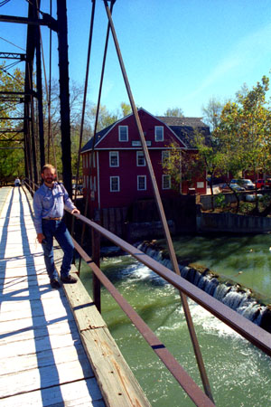
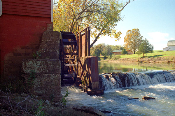
War Eagle Mill is the only working waterwheel-powered mill in Arkansas, and the only undershot water wheel currently in operation in the United States. Jewel's daughter, Zoe Medlin Caywood, not only gave new life to the mill but over the next thirty-years she developed many new products that show up as ingredients in the popular “War Eagle Mill Cookbooks” she authored. It was Zoe’s passion that fueled the Mill’s stature in the Ozark region.
I have two more pictures to include here. One looks north across the bridge at War Eagle Mill, and you can see that view here. Fred also got a nice picture of me on the bridge as I am looking downstream from the mill.
| NOTE: Six years after our visit, Zoe wanted to pass the Mill on to someone who loved it as much as she had over the 30 years her family owned the property. She sold it to a health-oriented, preservationist business couple from Eureka Springs, Arkansas. They furthered the availability and use of organic, Non-GMO, natural products. Visitors to War Eagle Mill can still see actual milling being done on site. |
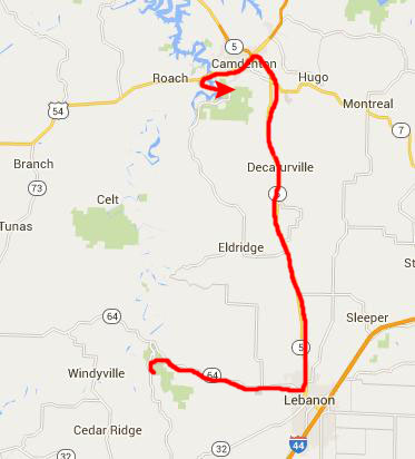
From War Eagle Mill, we headed off into Missouri to visit a couple of Missouri's popular state parks.
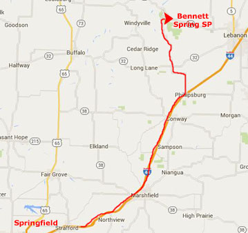
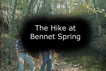
Bennet Spring State Park
|
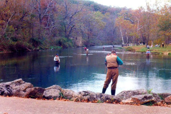
We arrived at the park in mid-morning. Bennett Spring State Park is located in Bennett Springs, Missouri, approximately 12 miles west of Lebanon on Highway 64 and is in Dallas and Laclede counties. The park was established in 1923. It is centered on the spring that flows into the Niangua River and gives the park its name. The spring averages 100 million gallons of daily flow and the park park offers fly fishing, camping, canoeing, and hiking, among other activities.
|
During the Civil War years, another mill was constructed by Peter Bennett. This Bennett Mill was larger and more successful than the Brice mill, and the spring soon took on the Bennett name. Peter died in 1882 and his son William Sherman Bennett took over. The Bennett Mill burned in 1895.
The state of Missouri set aside some of the nearby acreage for a public park, and, eventually, purchased much of the original Bennett family property, as the mill was never rebuilt. In the 1930s the Civilian Conservation Corps (CCC) made various improvements to the park- building the dining lodge, cabins, trails, roads, shelters, gauge station, and the arched stone bridge across the spring branch.
|
The Bennett Spring area was founded by pioneers who used the cool, rushing waters of the spring-fed stream for gristmills. Now, it’s one of America’s premier trout destinations where people come to wrestle with rainbow trout and fish a stream that’s stocked every night. Bennett Spring State Park has fishing, hiking that runs from simple to strenuous, and a lodge with hearty stick-to-your ribs food. The park's proximity to Interstate 44 makes it an easy trip from all parts of Missouri.
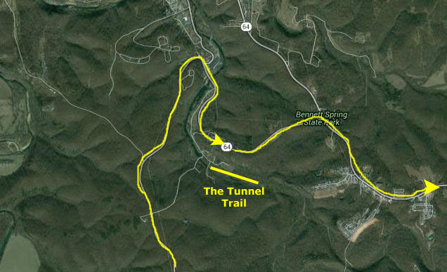
We were going to take the short Tunnel Trail hike, and so we crossed to the other side of the small lake that has been created above the dam, a lake crowded with the fishermen who come to catch the fish from the hatchery that are continually moved to the lake.
|
The trail crosses Spring Hollow and passes through many different habitats, including bottomland and upland forests, tall bluffs, sunny glades, small and large streams, and old farm fields. The trail is a combination of roads used by people living in the area from the 1840s to present and rugged wooded areas crossed by small streams. The wooded areas support abundant wildlife including deer, squirrels, chipmunks, many woodland birds and insects, including ticks. Several bluffs have interesting geologic features, tiny caves, sheer rock faces and deep overhangs with vines and other foliage.
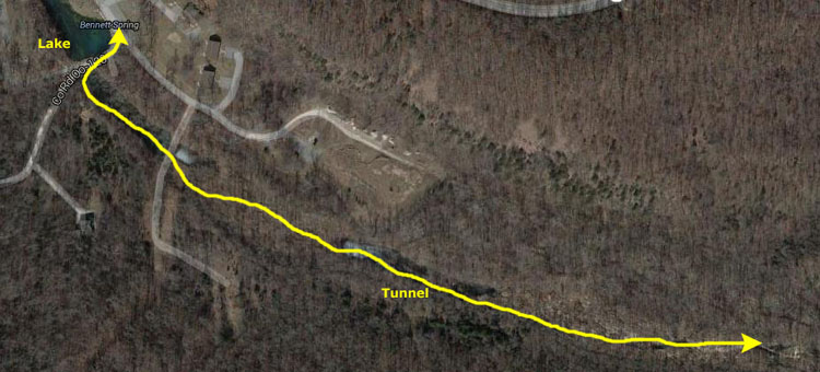
The trail passes near a small cemetery that dates from the late 1880s and holds the graves of two families who lived in the area. Upstream from the natural tunnel is a large overhang that may have been used as shelter by earlier travelers. The trail overlaps with Savanna Ridge Trail for a mile along the west side of Spring Hollow. Then we came to the trail’s signature feature- the Bennett Spring Natural Tunnel.
|
|
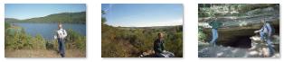
To view the slideshow, just click on the image at right and I will open the slideshow in a new window. In the slideshow, you can use the little arrows in the lower corners of each image to move from one to the next, and the index numbers in the upper left of each image will tell you where you are in the series. When you are finished looking at the pictures, just close the popup window.
We spent a couple of hours on the Natural Tunnel Trail, and a bit longer driving around the park before we headed off to Ha Ha Tonka State Park another sixty miles northeast.
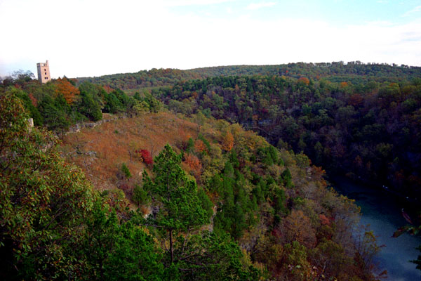
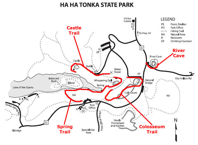
Ha Ha Tonka State Park
|
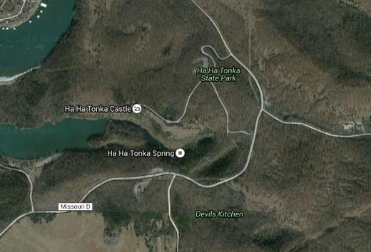 |
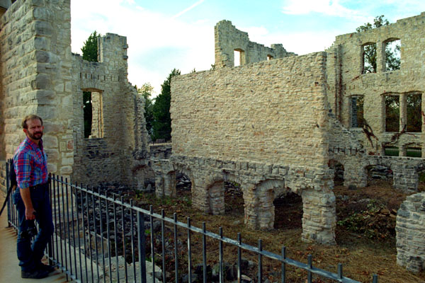
Ha Ha Tonka State Park is one of Missouri’s most visited spots, with its imposing architecture and beautiful scenery. Located on the Lake of the Ozarks, the park features the stone ruins of a turn-of-the-20th-century castle built by a prominent Kansas City businessman high atop a bluff. More than 15 miles of trails traverse the park, leading visitors to sinkholes, natural bridges, caves and down to the lake.
|
In 1904, he purchased Ha Ha Tonka Lake and Spring in Camden County and immediately began constructing roads and making extensive improvements. He once said, "Here I will spend my leisure, secure from the worries of business and the excitement of city life. I will fish and loaf and explore the caves of these hills, with no fear of intrusion." He did not live long enough to fulfill that hope, because, two years later, he became one of the first automobile fatalities in Missouri. In his lifetime his name was synonymous with honesty in business dealing, and he passed on to his son, Robert Jr. His son continued his father's successful business enterprises and on his death bequeathed a large portion of his land holding to the State of Missouri for the creation of a State Park for everyone to enjoy.
There were no campgrounds in the park, so we just spent the day hiking some of the many trails that we learned about at the Visitor Center, and we also visited Ha Ha Tonka Castle.
|
The park has quite a few relatively short trails, but most of them just wandered through the park, criss-crossing the park roads and going from picnic area to picnic area. But there were two hikes that we had read about beforehand.
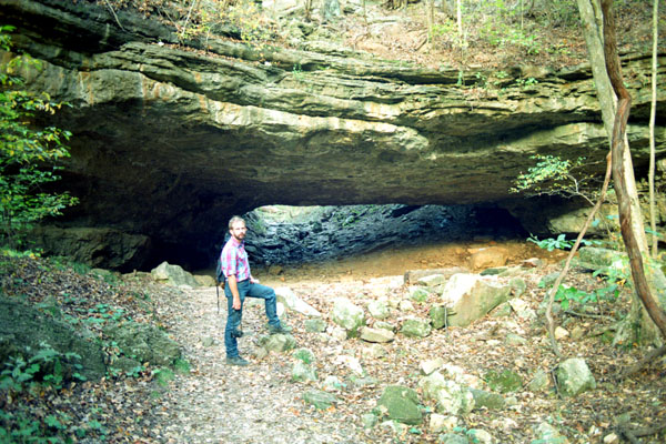
One of them, the Colosseum Trail, goes by two of the park's most famous natural features. One is a large sinkhole and the other is a natural bridge. The other trail, the Castle Trail, visits the ruins of the stone house that Snyder built.
The Colosseum Trail
|
Colosseum Sinkhole is a 150 foot deep sinkhole that is the result of the aforementioned cave collapse. Spring wildflowers are abundant in this sheltered enclave, especially in the section just beyond the natural bridge, where the trail is immediately adjacent to a sheer bluff a sheer bluff. Hiking out of the sinkhole at the south end, trail users will step between large boulders – evidence of the rocky ceiling that one covered this now open cave room. It is a long, steep climb out of the sinkhole to near the top of the ridge, but the views of the old post office, spring and castle ruins at the top are a great reason to hike this trail.
The figure eight loop then takes hikers across the top of the natural bridge and back to the trailhead. This trail was constructed in 1981 by park staff and volunteers to showcase the natural bridge and Colosseum Sinkhole.
The Spring Trail
The trail continued toward Ha Ha Tonka Spring along the shore of the old millpond, where there were turtles, frogs and toads, green herons and others. At the end of the millpond was another raceway that acted as a dam to the spring water during normal water levels. During periods of high water levels, Ha Ha Tonka Spring water runs over the raceway and flushes out the millpond into the lake.
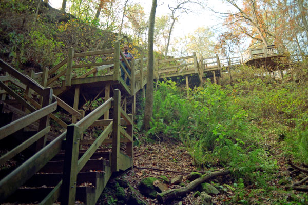
Shortly, the trail changed from pavement to wooden boardwalk. There were a couple of overlooks before we wound around and up the hill to the post office. From there, the trail continued back by the Colosseum Trail and back to one of the main parking areas.
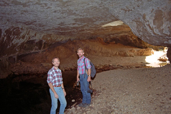
River Cave
|
We climbed back up to the top of the stairway and then walked back to the parking area to find the trailhead for the Castle Trail.
The Castle Trail
|
 |
Tomorrow will be a full day with a couple of stops near Springfield and then a long drive home, so we drove down towards Springfield this evening to get a motel room there.
|
There, we found a motel and got our room for the night.
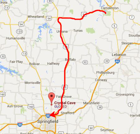
Crystal Cave
|
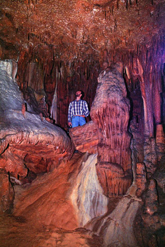
The setting was idyllic and the cave entertained countless tourists and other visitors over the decades. For many years of its operation, Crystal Caverns was the most prominent tourist attraction in the Cassville area. But that year, the owner ceased most operations, providing guided tours for a fee and only on request. When we arrived, there was one other group that we discovered would be going along with us.
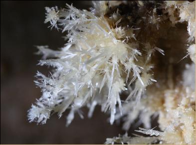
While Crystal Caverns does not have large speleothems, it does have a treasure trove of small cave formations. Translucent soda straws and small stalactites adorn many areas. Crystal Caverns is most noted for an impressive display of aragonite crystals with extremely fragile needle-like growths.
|
To view the slideshow, just click on the image at right and I will open the slideshow in a new window. In the slideshow, you can use the little arrows in the lower corners of each image to move from one to the next, and the index numbers in the upper left of each image will tell you where you are in the series. When you are finished looking at the pictures, just close the popup window.
As has been happening more in more in my photo album as I work my way backward (this particular page was constructed in 2015), there is news to report about what has happened to this site we visited since the time of that visit. As it turned out, we were among the last people to visit Crystal Caverns- as least among the general public. The owner stopped giving tours later in 1998, and by early 1999, all surface structures on the property vanished, along with the water supply and electrical service. Only a concrete slab and entrance structure remained. The concrete block entrance that contained a stairwell into the cave was overgrown with vines, was secured with a dubious lock and chain on a rickety steel door.
The cave was in dire straits; the absentee owners considered it a liability and made plans to bulldoze over the entrance and close the chapter on Crystal Caverns. Then, as chance would have it, the late Ron Parmer, a Missouri State mine and cave inspector, called the Missouri Caves Conservancy, and that organization, dedicated to preserving and protecting caves and karst resources in the state, began leasing the cave and 160 surrounding acres.
In the years following, the old corroded lights and wiring were removed from the cave and some old worn handrails were replaced. The vandalized door to the man-made entrance was replaced and other improvements made. The cave was extensively surveyed, amassing some 2,000 feet of mapped passage. Besides being one of the longest mapped caves in Barry County, the cave has an overall depth of about 100 feet from top to bottom.
|
Today, the cave is used by the conservancy for research, and new formations have been uncovered and catalogued. The cave is noted for its pure white stalactites and the impressive speleothems that adorn the "Queen’s Attic". The Fossil Room contains beautiful speleothems in one area and is known for its fossil-rich ceiling of Burlington limestone. Among raised relief of crinoid remains are brachipods and horn corals. Beyond the Fossil Room, through a low, muddy, belly-crawl lies the Enchanted Forest, a small room with the cave’s largest, most spectacular flowstone and a profusion of delicate soda straws, helictites, calcite wings and columns.
The cave has been used as an educational resource since the conservancy began its stewardship more than a decade ago.
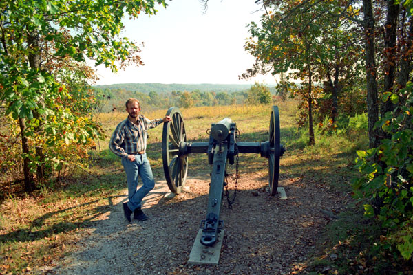
Wilson's Creek National Battlefield
|
Wilson's Creek National Battlefield, near Republic, Missouri, preserves the site of the Battle of Wilson's Creek. Fought on August 10, 1861, it was the first major American Civil War engagement west of the Mississippi River. The Confederate's failure to exploit their victory here resulted in keeping Missouri in the Union. Major features include a 5-mile automobile tour loop, the restored 1852 Ray House, and "Bloody Hill," the scene of the major battle. The site is located just southwest of the city of Springfield, in southwestern Missouri.
The Battle of Wilson's Creek, also known as the Battle of Oak Hills, was the first major battle of the Trans-Mississippi Theater of the American Civil War. Fought on August 10, 1861, near Springfield, Missouri, between Union forces and the Missouri State Guard, it is sometimes called the "Bull Run of the West."
Despite Missouri's neutral status at the beginning of the war, tensions escalated between Federal forces and state forces in the months leading up to the battle. In early August 1861, Confederate troops under the command of Brig. Gen. Benjamin McCulloch approached Brig. Gen. Nathaniel Lyon's Army of the West, which was camped at Springfield. On August 9, both sides formulated plans to attack the other.
|
The Confederate victory buoyed Southern sympathizers in Missouri and served as a springboard for a bold thrust north that carried Sterling Price and his Missouri State Guard as far as Lexington. In late October, a convention organized by Governor Claiborne Fox Jackson met in Neosho and passed out an ordinance of secession. Although the state remained in the Union for the remainder of the war, the Battle of Wilson's Creek effectively gave the Confederates control of southwestern Missouri.
The battle site was established as Wilson's Creek National Battlefield Park on April 22, 1960, and was redesignated a National Battlefield on December 16, 1970. As with all historic areas administered by the National Park Service, the battlefield was listed on the National Register of Historic Places on October 15, 1966.
|
The Wilson's Creek Civil War Museum (formerly the General Sweeny Museum), contains artifacts relating to the war west of the Mississippi and exhibits about the war and war life, and was located north of the visitor's center.
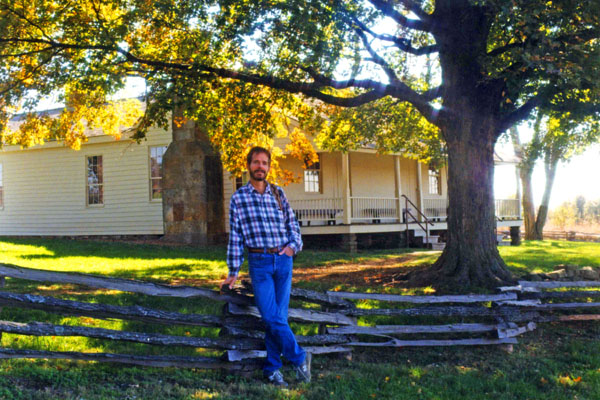
The 1850s Ray House is a historic house museum that was the site of a temporary field hospital for Southern soldiers after the battle. It wasn't the case when we visited, but the house is now open on weekends in the summer, with interpreters dressed in period clothing giving guided tours.
When we arrived back at the visitor center, we thought about stopping in at the library, but did not. The John K. and Ruth Hulston Civil War Research Library was founded in 1985, and when we visited was a set of rooms just off the visitor center. A new library building was dedicated in April 2003. The core of the library collection was donated by Springfield attorney John K. Hulston and his wife Ruth. Currently the library contains approximately 10,000 volumes concentrating on the Civil War period and the Civil War in the Trans-Mississippi Theater.
|
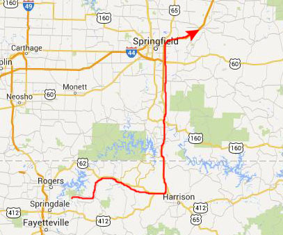
We took county roads to get to US Highway 60 west. This brought us to Interstate 44 southwest of Joplin. We stayed on the Interstate for a while until we saw the signs for US Highway 75 south to Muskogee, Durant and, eventually, Dallas.
As we've done frequently, we stoppped for dinner at the El Chico in Sherman, getting back to Fred's house about ten in the evening.
This was a nice fall trip, although short, and we got to see quite a bit.
You can use the links below to continue to another photo album page.
|
October 31 - November 2, 1998: My Sister Judy Visits Dallas |
|
September 19, 1998: Jeffie and Her Horse |
|
Return to the Index for 1998 |