|
July 15, 1999: Napa Valley and San Francisco |
|
Return to the Index for Our California Trip |
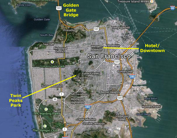
Today, our last full day out here in California, I want to show Fred a few spots in the city of San Francisco that I have visited before- such as Twin Peaks, the Golden Gate Bridge and Sausalito. We will spend all day here, and catch the red-eye flight back to Dallas about midnight.
In San Francisco: Twin Peaks
|
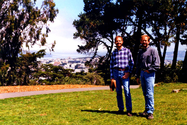
Each peak has its own name: Eureka Peak is the northernmost, and Noe Peak is south of it. From Eureka Peak, there are great views of the city and San Francisco Bay. The top of the peaks is undeveloped- part of the 31-acre Twin Peaks Natural Area, managed and owned by the San Francisco Recreation and Parks Department. These preserved areas are home to many natural resources and wildlife. Many bird species, insects and vegetation thrive in these areas.
The Muni Metro Twin Peaks Tunnel runs beneath Twin Peaks, linking Downtown San Francisco with West Portal and the southwestern part of the city. There is no public transportation all the way to the top of the Peaks, but the 37 Corbett Muni line stops on Crestline Drive near a path up the hill.
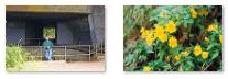
At the beginning of the path were some interesting purple flowers, and Fred stopped to photograph them before we headed up the hill to the top of the peak.
|
 |
On the way down, Fred found another flower to photograph. Back down at the bottom of the hill, I thought I would drive Fred to nearby Castro Street, since just about every "family" member has heard of it. We parked and just walked up and down the street on this sunny weeday morning. I was able to also get the iconic Castro district picture- Fred standing by the street sign just outside the Castro BART station building. You can see that picture here.
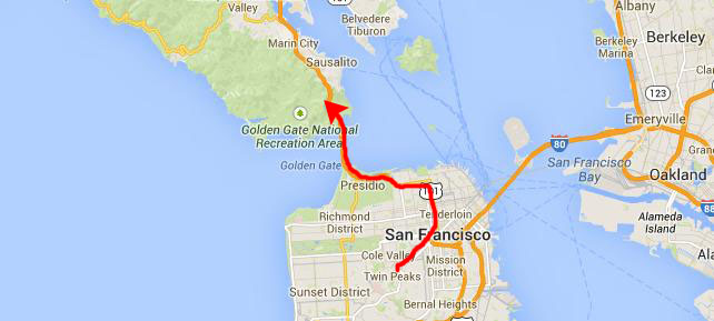
We got back in the car and I took us across town towards the next sight I wanted Fred to see: the Golden Gate Bridge. As we drove through town, Fred snapped a picture of this typical San Francisco Street just off Van Ness.
The Golden Gate Bridge
|
Highway 101 is the California coast highway (and indeed goes pretty much from Seattle to San Diego, most times right along the coast). You may have heard reference to the "PCH"; that stands for Pacific Coast Highway, a term used mostly in Southern California. Up here in the north, it is simply "the 101". That's the highway that crosses the Golden Gate Bridge, so we headed north through the southern part of the Golden Gate National Recreation Area (which encompasses the former Presidio), through the toll plaza and out onto the bridge itself.
If I had had the technology to make movies in 1999, I would have made one as we crossed the bridge, but I didn't. And if we'd been using digital photography, Fred would have been snapping pictures continually as we crossed, but we didn't have that technology, either. So we thought we would just wait until we could get out of the car and walk onto the bridge to take our pictures.
|
Although the idea of a bridge spanning the Golden Gate was not new, the proposal that eventually took hold was made in 1916 when San Francisco's City Engineer estimated the cost at $100 million ($2.12 billion in 2009 dollars), and impractical for the time. He asked bridge engineers whether it could be built for less. One who responded, Joseph Strauss, was an ambitious engineer and poet who had, for his graduate thesis, designed a 55-mile-long railroad bridge across the Bering Strait. At the time, Strauss had completed some 400 drawbridgesŚ most of which were inlandŚ and nothing on the scale of the new project. Strauss's initial drawings were for a massive cantilever on each side of the strait, connected by a central suspension segment, which Strauss promised could be built for $17 million. Eventually, it was decided that a suspension design was more practical, and for ten years, support was drummed up for the project- much of that work done by Strauss himself.
Construction began on January 5, 1933. The project cost more than $35 million, and was completed ahead of schedule and under budget. The Golden Gate Bridge construction project was carried out by the McClintic-Marshall Construction Co., a subsidiary of Bethlehem Steel Corporation. Strauss remained head of the project, overseeing day-to-day construction and making some groundbreaking contributions. He innovated the use of movable safety netting beneath the construction site, which saved the lives of many otherwise-unprotected steelworkers. Of eleven men killed from falls during construction, ten were killed just before completion when the net failed under the stress of a scaffold that had fallen.
The Golden Gate Bridge opened in 1937 and had, until 1964, the longest suspension bridge main span in the world, at 4,200 feet. During the bridge work, the Assistant Civil Engineer of California Alfred Finnila had overseen the entire iron work of the bridge as well as half of the bridge's road work. With the death of Jack Balestreri in April 2012, all workers involved in the original construction are now deceased.
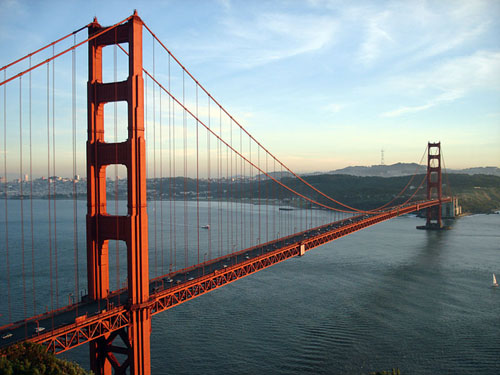
If you have not visited the bridge, it is an amazing sight and an even more amazing engineering feat- particularly for its time. It is a treat to drive across (although commuters from Marin County probably don't give it a second thought). Below I have put an aerial view of the bridge in a scrollable window. I have turned the view on its side to fit better on the page; when this page loads, the northern end of the bridge is at the left.
We drove across the bridge to the Marin Headlands, and took the first exit off to our right to an observation point and its parking area. We actually had to circle the parking area once or twice- it is an incredibly popular and busy place.
|
 |
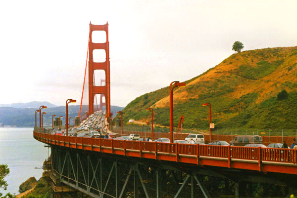
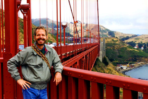
Before we headed off to walk up onto the bridge, I took this picture looking south of Fred and the Golden Gate Bridge. Then we went up onto the bridge itself. The bridge is popular with pedestrians and bicyclists, and was built with walkways on either side of the six vehicle traffic lanes. When we were here, these walkways were separated from the traffic lanes by only a metal curb, and I recall commenting to Fred that I wouldn't want to be a bicyclist or pedestrian and tumble into the roadway. I guess someone overheard me; railings between the walkways and the traffic lanes were added in 2003.
The main walkway is on the eastern side, and is open for use by both pedestrians and bicycles in the morning to mid-afternoon during weekdays and to pedestrians only for the remaining daylight hours. The eastern walkway is reserved for pedestrians on weekends, but open exclusively to bicyclists in the evening and overnight, when it is closed to pedestrians. The western walkway is open only for bicyclists and only during the hours when they are not allowed on the eastern walkway. This all seems kind of confusing, but I guess if you live here and use the bridge frequently as either a bicyclist or pedestrian, I guess the various openings and closures become quite familiar.
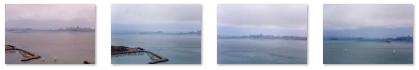
Anyway, we headed out on the east side walkway, and right away we had great views of the city and the bay and now that we were a bit higher up, we could see the Marin Headland that lies south of Sausalito east of Highway 101. (I might point out here that one of the things we learned by reading some of the signage in the parking area was that Highway 101 does not actually cross the bridge; for some reason, the California Highway Department shows Highway 101 as ending at the toll plaza south of the bridge and picking up again when the roadway comes off the bridge on the north. But I think the distinction is lost on just about everyone, including residents of the Bay Area.)
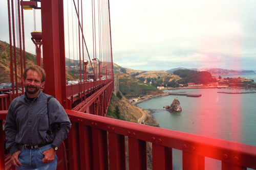
While we could have walked across the entire bridge, we just walked out to the first tower to have a look around. This view, looking south along the east side, shows Fred at the North Tower of the bridge. We also took photos of each other at the tower, both looking north back towards Marin County. Those views are below:
 |
 |
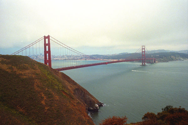
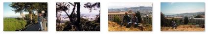
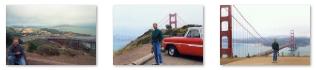
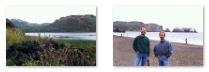
Walking out on the bridge was really interesting; in all the times I have been here, I have never crossed it on foot or on a bicycle. But I also wanted to take Fred higher up in the Marin Headland so show him some more of the impressive views of the bridge and the city.
|
I might point out that this part of the peninsula is set aside as the Golden Gate National Recreation Area, and the set-aside (which was almost given over to development a half-century ago) extends three or four miles to the north. When it ends, you have the developed area generally known as Marin County. There one finds beautiful homes on the rolling hillsides, John Muir Woods, an area of giant redwoods that we won't have time to visit today, and Mt. Tamalpais with its maze of hiking trails leading to some of the best views in the entire Bay Area. I have driven and hiked some in that area in the past, and used to have a high school friend who lived there.
Marin Headlands Overlooks
|
|
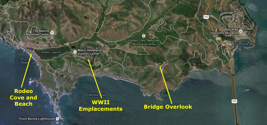
After the last overlook, we came to the crest of the headland, and here we stopped to have a look at some history.
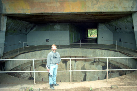
WWII Emplacements on the Marin Headlands
|
During World War II Batteries Wallace, Townsley, and 129 on Hawk Hill were built into the hills to protect them from aerial bombardment and the high caliber shells that would be fired by Axis battleships. The emplacements at the top of Hawk Hill were used for a radio station. During the Cold War, the gun batteries were decommissioned, but antiaircraft missile sites were built on the northern and southern sides of Rodeo Lagoon. Radar sites were placed atop Hawk Hill and Hill 88. At several locations, shelters were built into the hillsides to protect the military personnel from the use of nuclear, biological, or chemical weapons.
Click on the thumbnail images below to see some additional pictures we took while wandering around these sites:
 |
Observation posts known as base end stations can also be found in the Headlands. A well-preserved example can be seen near the northern end of Rodeo Beach, and others are located near the Point Bonita Lighthouse and on Wolf Ridge as it slopes down to the sea.
All military sites in the Headlands are now decommissioned and returned to civilian use. Some military facilities, such as SF-88, have been preserved as historical sites. Many historical buildings are now used by non-profit organizations, but maintained in their historical condition.
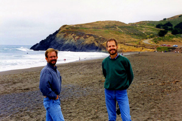
Rodeo Cove
|
Click on the thumbnail images below for a couple more pictures from Rodeo Cove:
 |
This beach is unique among California beaches in that it is largely made up of coarse, pebbly chert grains, both red and green in color. Its mineral composition sets it apart from every other beach in the state. Surfing is possible throughout the year and at all tidal stages, but is best in summerŚ although there is a risk of shark attacks.
We had a really good time here in the Marin Headlands, but there was one other place we wanted to stop.
Sausalito
|
Sausalito is the nearest city in Marin County to the city of San Francisco (which is in San Francisco County). It lies 8 miles south-southeast of San Rafael- the largest city in Marin County. Sausalito is indeed a seaside community, with an average elevation of only 13 feet. As of 2010, the city itself had a population of only 7500, but it is one of those towns that have lots of people living nearby but outside the town itself.
Sausalito was just a ten-minute ride from the Golden Gate Bridge, and is one of those California cities whose name immediately conjures up a certain image.
Prior to the opening of the Golden Gate Bridge, the city was a terminus for rail, car, and ferry traffic. It developed rapidly as a shipbuilding center during World War II; after the war, the city's industrial character changed dramatically, and by the 1950s had the reputation of being a wealthy and artistic enclave, a picturesque residential community (incorporating large numbers of houseboats), and a tourist destination. Keeping it from developing and losing this character is the fact that it is adjacent to, and largely bounded by, the protected spaces of the Golden Gate National Recreation Area.
|
In the 1870s, the North Pacific Coast Railroad (NPC) extended its tracks southward to a new terminus in Sausalito, where a rail yard and ferry to San Francisco were established. The NPC was acquired by the North Shore Railroad in 1902, which in turn was absorbed in 1907 by the Southern Pacific affiliate, the Northwestern Pacific.
By 1926, a major auto ferry across the Golden Gate was established, running to the Hyde Street Pier in San Francisco. This ferry was an integral part of old U.S. Highway 101, and a large influx of automobile traffic, often parked or idling in long queues, became a dominant characteristic of the town. Northwestern Pacific commuter train service also expanded to serve the increased traffic volume, and Sausalito became known primarily as a transportation hub.
This era came to an end in May 1937, with the opening of the Golden Gate Bridge. The bridge made large-scale ferry operations redundant, and since the new route of Highway 101 bypassed Sausalito entirely, in-town traffic was quickly reduced to a trickle. Car ferry service ended in March 1941 (passenger ferry service, however, continues to this day, linking downtown Sausalito with both the Ferry Building in San Francisco's Embarcadero, and Pier 39 in the Fisherman's Wharf district). Northwestern Pacific also closed its Sausalito terminal in March 1941, although some tracks remained in use as "spur tracks" for freight trains as late as 1971.
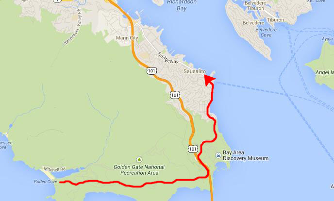
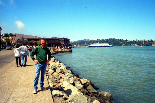
We drove along the shore from the south, parking on a side street near the north end of town. We stopped first for a bit of lunch, and then walked south along the shore. By this time, it had turned into a beautiful afternoon.
|
Click on the thumbnail images below to see three candid shots that we took while walking along the Bay here in Sausalito:
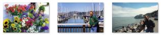 |
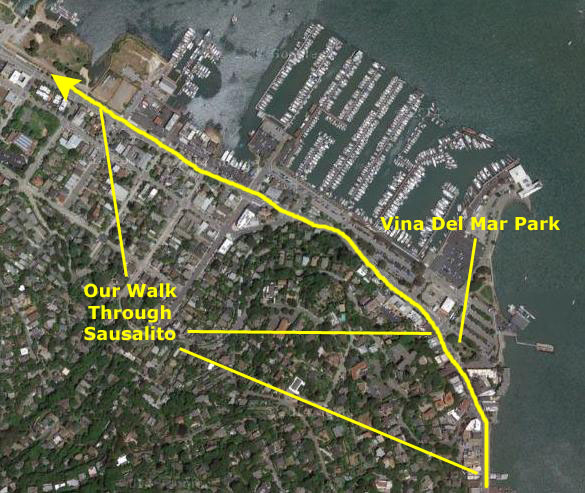
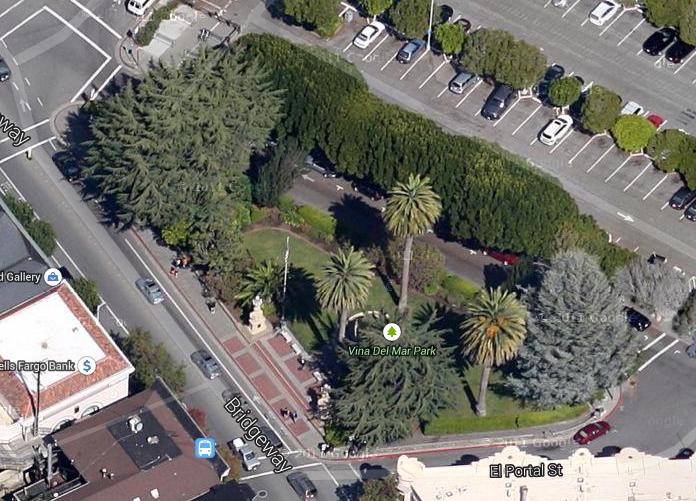
There was a small park quite near where we parked, and another one a ways south, near where the shore curves around towards the bridge. This second park was called Vina Del Mar Park.
In the late 1950s, President Eisenhower announced a program to encourage American cities and towns to "adopt" similar cities and towns around the world, as part of his "People-to-People" program. I am sure you have seen many of the results of this program in the areas where you live. Dallas, for example, has a sister city. Well, to be accurate, it has eight "sister" cities (I guess we think Dallas is such an important place that one is not enough; Dallas is nothing if not self-important). If you are curious, our sister cities are: Brno, Czech Republic; Kolkata, West Bengal, India; Dijon, France; Monterrey, Mexico; Riga, Latvia; Saratov, Russia; Taipei, Taiwan; Recife, Brazil.
|
At right is an aerial view of Vi˝a del Mar Park. You can just see the circular fountain nestled near the tall palm trees, and you can see the two elephant statues flanking the seating plaza streetside. If you would like to see our pictures of either feature, just click on it (for the elephant statue, click on the northern one that is in full sunlight).
About five in the afternoon, we headed back to the car. On the way to the airport, I wanted to show Fred some more of the Bay Area.
Driving to the Airport
|
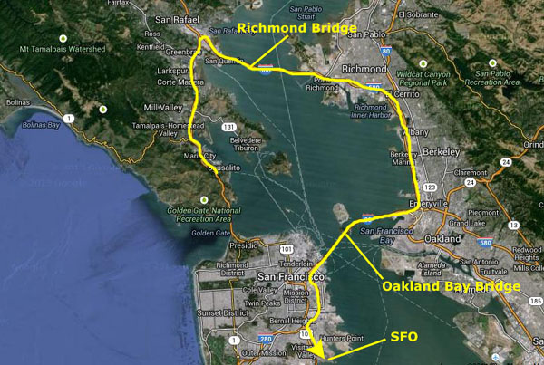
We then got onto I-80 which comes down from Sacramento and heads to Oakland. We just stayed on I-80 as it turned west again to head out across the Oakland-Bay Bridge towards San Francisco. This bridge is in two parts, broken up with its passage across Treasure Island/Yerba Buena.
Then we just got off I-80 (which ends in San Francisco) and back onto Highway 101 to head south to the airport. I thought about taking Fred up into the hills to see the San Andreas Fault, but didn't want to be under time pressure for our flight later this evening. So we just drove a bit south on the Peninsula, found a local restaurant, had dinner, and then went back to turn in the rental car at the airport. We were at the gate about two hours before our midnight flight back to Dallas.
This trip to California was really nice, and Fred got to see all different kinds of scenery- from National Parks to man-made engineering wonders. But there is more to do here, and we might return again.
You can use the links below to continue to another photo album page.
|
July 15, 1999: Napa Valley and San Francisco |
|
Return to the Index for Our California Trip |