|
July 1, 2000: North Carolina Trip- Day 2 |
|
Return to the Master Index for the North Carolina Trip |
Fred and I began out trip to North Carolina on Thursday evening with a flight to Greensboro. We planned to camp in the Appalachians, so a few days earlier we'd gone out and bought a large canvas carrier that would hold our tent, our large double sleeping bag and pillows, and all the equipment for setting everything up. On previous camping trips, we had also taken stuff to fix our meals at the campsite, but that kind of stuff can't be carried on or checked on a plane- at least not easily. So what we plan on doing is buying a cooler (which we would do at the Wal-Mart near my sister's house) to carry drinks and sandwich stuff for lunch, but we'd have our suppers at local places when we could find them.
Getting to North Carolina (6/29)
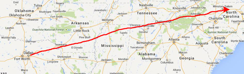 |
When we landed in Greensboro, we rented our car and then drove immediately to my sister's house outside Elon, North Carolina.
|
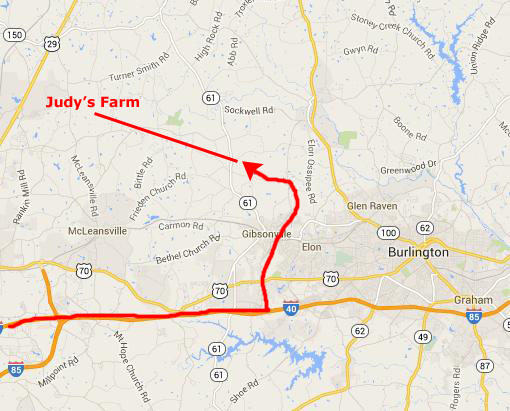
Actually, there are lots of ways to get there, almost all of them pretty much the same. Through Gibsonville, we head northwest on Elon-Ossippee Road to Lowe Road, then left and about a half mile to Judy's front gate.
We got there fairly late, and so did fairly little before getting to bed. We did discover that my niece Jeffie had come up for a visit, which was a nice surprise.
At My Sister's House Outside Elon, NC (6/30)
|
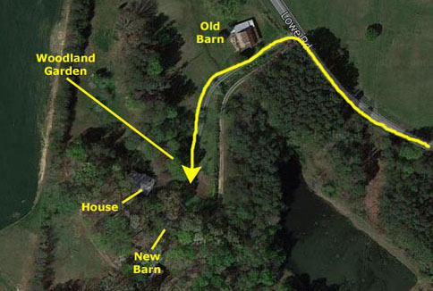 |
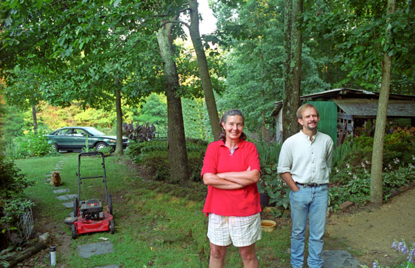
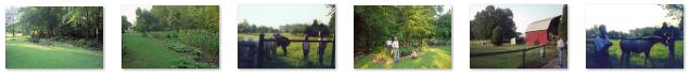
It was nice to see both Jeffie and Judy, and we spent a pleasant hour or two wandering around her farm, looking at all the work she's done and visiting with her horses. Judy boards horses for other folks, and one of the young girls whose horse is there was also wandering around with us. Below are clickable thumbnails for some of the pictures we took at Judy's farm this morning:
 |
A Visit to Montreat, NC (6/30)
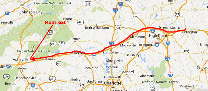 |
Montreat is a town in Buncombe County, up by Asheville (and is considered part of the greater Asheville area). The town is best known for Montreat Conference Center, Montreat College, and for being the home of evangelist Billy Graham and his late wife Ruth Bell Graham.
|
 |
The town of Montreat was incorporated as a North Carolina township in 1967. Much of the property in the area is still owned by the Mountain Retreat Association, formed in 1897 by John Collins, a Congregationalist minister from Connecticut.
|
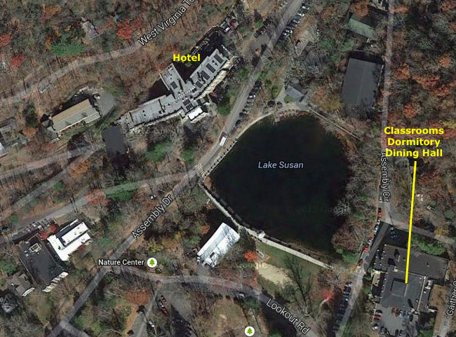
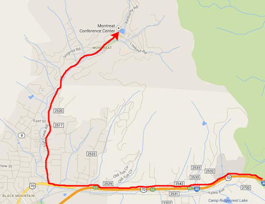
At right is an aerial view of Montreat; one of the things that makes the town so picturesque is the existence of Lake Susan- a mountain stream-fed lake that lies between the hotel and conference center and some of the buildings of Montreat College.
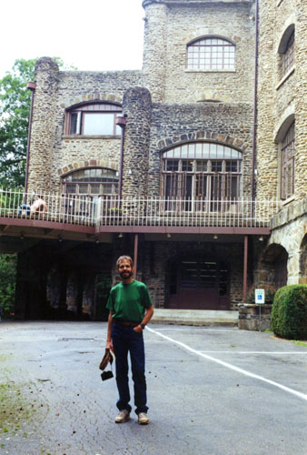
You may wonder why we stopped here. Well, this was something of a nostalgia visit for me. Between my graduation from Myers Park and my matriculation at Davidson College, I spent two summer months here, working in the dining hall and doing a lot of hiking all around the area. I got the job through Avondale Presbyterian Church, which I attended off and on during my childhood. I also knew the pastor and his kids, whom I went to school with. I wanted a little extra money for college, and didn't have any desire to spend a summer at home in Charlotte, so I applied for and got a job, and took the train from Charlotte to Black Mountain. As it turned out, my sister, who was already at Coker College in South Carolina, also got a job there that summer; she worked in the hotel and conference center.
While the work was OK, the real attraction for me was that Montreat was a lot cooler in the summer than Charlotte, and I'd be away from home and on my own. Although I didn't know it when I applied, I would also find that the hiking in the area was really, really great. Every few days I would take one of the five or six different mountain hikes that all began right by Lake Susan, and went up to either Lookout Mountain (the most popular hike) or other mountains whose names I have forgotten. I enjoyed every hike I took, whether I wasy by myself or with a group. Lookout Mountain was the venue for a good many Saturday-night gatherings.
|
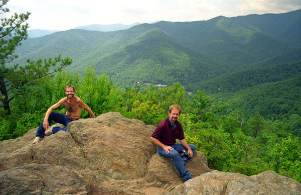
One of the reasons for bringing Fred here was to return the favor of his taking me to the top of Guadalupe Peak in Texas; I wanted to take him to the top of Lookout Mountain. So relying on only my memory, we walked up Lookout Road to the trailhead for the hike and then I unerringly followed the path (including a couple of places where you have to walk along a logging road for a ways to pick up the trail again) to the top of the mountain where, as you can see from the picture at left, the views are pretty spectacular.
I very much enjoyed the hike- not because it was one of the best we'd taken, or even the most scenic- but because it brought back so many memories. Most of the hiking Fred and I have done has been out west; we'd not hiked such a heavily-forested area before (though we would do such hikes in the coming years). Looking off across the Blue Ridge is always an awe-inspiring experience, as the Great Smoky Mountains- much, much older than the craggy mountains out west- stretch off into the distance. We took one more good picture from Lookout Mountain, and it is below:
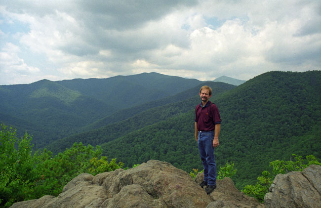 Fred Atop Lookout Mountain |
I can't help but remark, writing this in the year 2014 as I am, that had digital photography been available when we took this trip, both Fred and I would have taken many, many more pictures- on the hike up and down and here from the top of the mountain. I would love to have a 360° shot from the top of the mountain, but the technology didn't exist then. Maybe one day, on another trip back here, I can do this hike again and show you how beautiful the Blue Ridge really is.
Crabtree Falls (6/30)
The first few waterfalls we'd marked for a visit, were north of Asheville, and all accessible from the Blue Ridge Parkway. This would give us an additional interesting thing to do today- to drive north from Asheville along the Parkway, as beautiful as I remember it and on anyone's list one of America's most beautiful drives.
|
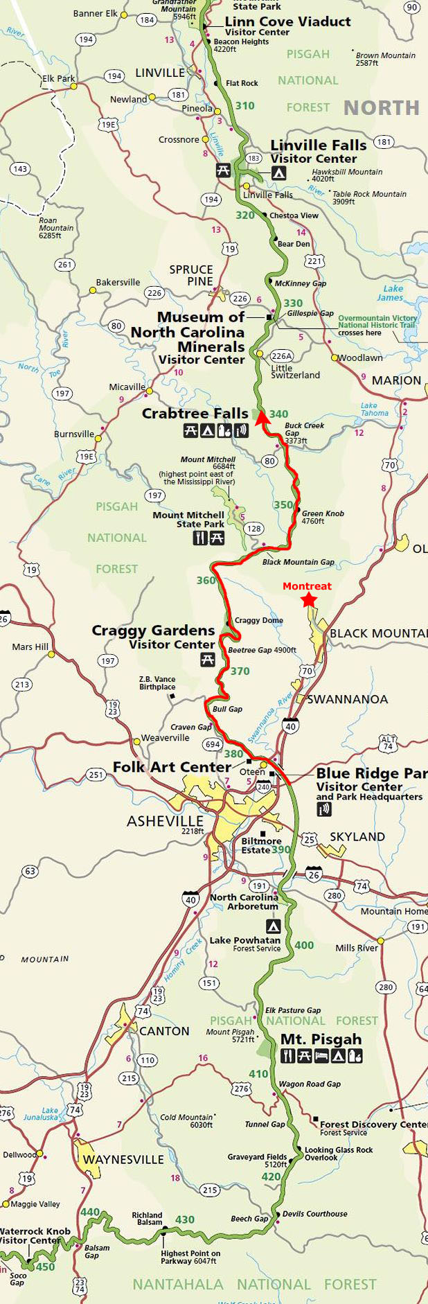
I think it would be a good idea to include a map of the Blue Ridge Parkway here so you can follow us along, and that map is in the scrollable window at left. To find this first section of the Parkway on the map, just scroll down until you can see Montreat and Asheville marked on the map, and then you'll see our first section of our Parkway drive marked in red.
This would be Fred's first visit to The Blue Ridge Parkway, which is classified as a National Parkway and All-American Road. The Parkway runs for 469 miles through twenty-nine Virginia and North Carolina counties, mostly along the Blue Ridge, a major mountain chain that is part of the Appalachian Mountains. Its southern terminus is on the boundary between Great Smoky Mountains National Park and the Cherokee Indian Reservation in North Carolina, from which it travels north to Shenandoah National Park in Virginia and offers access to the Skyline Drive. While the two roads join together end-to-end, they are separate and distinct entities, built as two different projects and managed by two different National Park Service units. The Blue Ridge Parkway was built to connect Shenandoah National Park to the Great Smoky Mountains National Park.
The Parkway, while not a "National Park," has been the most visited unit of the National Park System every year since 1946 except one (1949). Land on either side of the road is owned and maintained by the National Park Service and, in many places, parkway land is bordered by United States Forest Service property. I, myself, have driven at least part of the Parkway on many different occasions; it is always a joy and a pleasure, for there is always someplace to stop and beautiful scenery to make you forget that the top speed is 50MPH. The road is not designed to get you from place to place quickly- there are Interstates for that. Indeed, the drive is the destination.
|
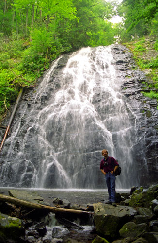
The trailhead for the hike to the falls was located in the Crabtree Meadows campground at Parkway mile marker 339. We parked in the lot where there were maybe ten other cars, and set out on the trail. The 2.5-mile, moderately strenuous loop trail leads to a footbridge over the creek at the base of the falls. The trail to the falls is a rugged, downhill, 1-mile hike, while the return, 1.5 mile trail is a gentler uphill return that follows Crabtree Creek.
Crabtree Falls is a 70-foot cascade that spreads over a rock face with many small ledges, giving it a delicate appearance, before trickling into a clear pool at the base. Though there are hardly any crabtrees here now, in the spring, an impressive array of wildflowers abound on the trail, including four species of trillium. By July, ferns fill the forest and soak in the spray of the falls, with rosebay rhododendron in bloom. Below are clickable thumbnails for some other views of Crabtree Falls:
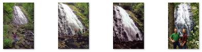 |
Various maps and hiking books label the falls we stopped at the "Upper Falls," as these maps and guides show another waterfall some distance away and on another creek being called Crabtree Falls. Originally, this waterfall was known as "Murphy's Falls" and a small community was located nearby, including a church and blacksmith shop. When the Blue Ridge Parkway was constructed in the 1930s, the falls was given its present name by the National Park Service.
We enjoyed our hike to the falls immensely, and must have spent at least an hour wandering around them.
At the Crabtree Falls Campground (6/30)
|
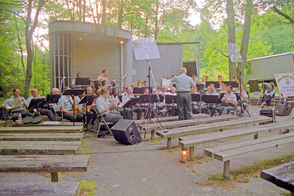
Afterwards, we walked over to the amphitheatre for what was described on the campground bulletin board as a concert by Park personnel. We got there ahead of most of the other campers, and I guess when the concert started there were maybe twenty-five or thirty folks around. It was, as I remember, perhaps 45 minutes of music. Not the Dallas Symphony, but then the DSO doesn't usually perform in such beautiful outdoor surroundings.
A nice end to a pleasant day.
You can use the links below to continue to another photo album page.
|
July 1, 2000: North Carolina Trip- Day 2 |
|
Return to the Master Index for the North Carolina Trip |