|
November 19, 2000: My Birthday |
|
September 29-31, 2000: A Trip to Austin, Texas |
|
Return to the Index for 2000 |
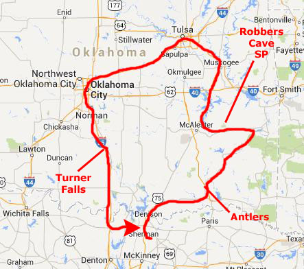
We have set aside a weekend in October to take a short trip to Oklahoma. We have planned to spend a day at Robber's Cave State Park in the eastern part of the state, drive through Tulsa and visit the Gilcrease Museum, and then spend a day in Oklahoma City to see the Memorial built to commemorate the 1995 bombing of the Murrah Federal Building. One the way home, we will stop by Turner Falls.
A Stop in Antlers, Oklahoma (10/26)
|
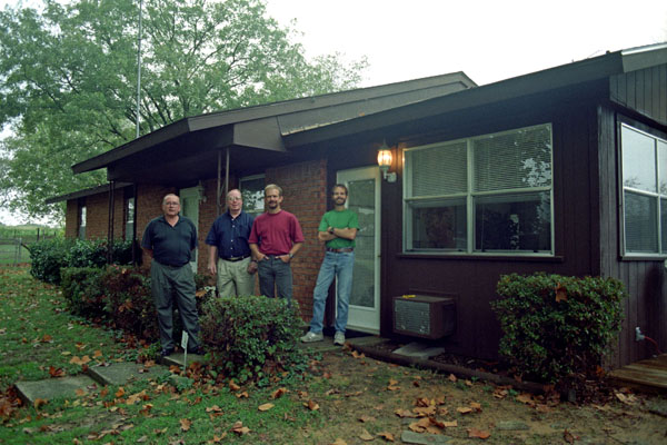
We followed the directions Barry had given us and with only one wrong turn, found their house, which is situated on a country road southwest of the center of town. We had a nice afternoon visit, and drove into town with them to have a look around. Antlers and the rest of the Kiamichi River valley fell within the realm of the American Indian culture based at Spiro Mounds; Sherman himself is, I believe, one-quarter Choctaw. The Mississippian culture that was based nearby controlled a large portion of what is now southeastern Oklahoma and adjacent states.
More recently, nomadic Caddo Indians roamed the area. Rarely establishing permanent settlements, they were highly mobile and hunted and fished across the region. The area that is now Antlers was granted to the Choctaw Indians in 1832 by the Treaty of Dancing Rabbit Creek. During the 1880s the St. Louis-San Francisco Railway built a north-south line through the Choctaw Nation, connecting Fort Smith, Arkansas with Paris, Texas, and stations were established to provide maintenance support for the railway and to help open up the territory. The site of Antlers was selected for a station due to the existence of a freshwater spring.
The sparsely populated area, at that time known as Jack’s Fork County of the Choctaw Nation, in the Indian Territory, was home to Choctaw Indians who farmed or subsisted on the land. Few roads or trails existed. Transportation was provided by the Railroad, until, beginning in the 1950s, highways, including US 271 and the Indian Nation Turnpike, were opened up through 1970. In 1981, the railroad closed altogether and its rails were removed.
|
A United States Court was established at Antlers, and a large wooden courthouse was built. As part of the preparations for Oklahoma statehood, Antlers was surveyed in 1901 and a townsite of 182 acres was mapped. Once the area was included in a state, residents could establish formal ownership of their homes and property; this occurred on November 16, 1907, and the Choctaw Nation and the Indian Territory ceased to exist. Antlers lost its prized status as a United States Court town, as many residents left for larger towns, and the town began to serve recreational and tourist visitors. Sustained growth occurred for several decades, until April 12, 1945, when Antlers was devastated by an F5 tornado; it killed 67 and injured 300.
The postwar years saw continued slow growth in the area, and Antlers when through the same growth trajectory as many American small towns. The advent of electricity and air-conditioning kept more folks at home, so downtown entertainment languished. Large stores opened on outskirts of the town, so downtown businesses struggled and many ceased operation. In recent years, money coming in from retirees and tourists has allowed some downtown gentrification, as buildings are refurbished in their pre-war style.
Robbers Cave State Park (10/27)
|
The area surrounding the present-day park has been a hunting ground for hundreds of years. Archaeological evidence suggests that the earliest people were related to the builders of the Spiro Mounds. By the 1600s, the Osage and Caddo tribes dominated the area. French hunters and explorers also visited, leaving their mark by naming some of the prominent geographic features, which are still used. It was after the Civil War, that this area became legendary for sheltering fugitives from the law- like Starr and James. Other fugitives reputed to have holed up here included the Dalton Gang, the Youngers and the Rufus Buck Gang.
The park's history began in 1929 when Carlton Weaver, an editor and politician from Wilburton, donated 120 acres of land near Robbers Cave to the Boy Scouts, and skilled inmates from the Oklahoma State Penitentiary constructed camp improvements. This acerage was adjacent to another tract that Weaver had leased to create a game preserve- which Weaver also later donated. The CCC, organized in 1933, built more improvements and also created a lake named for Weaver (Lake Carlton). Two other lakes were created later when a dam was built on Fourche Maline Creek.
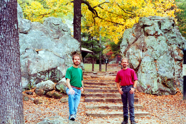
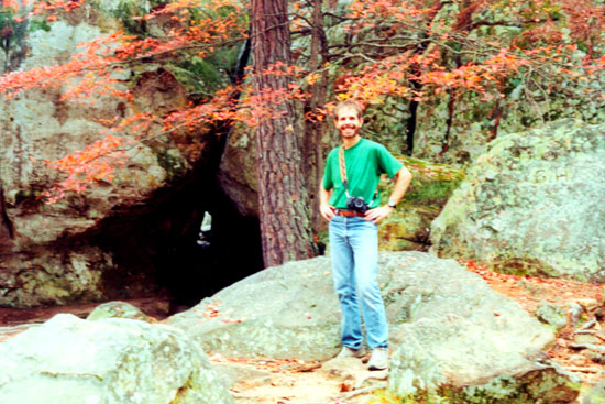
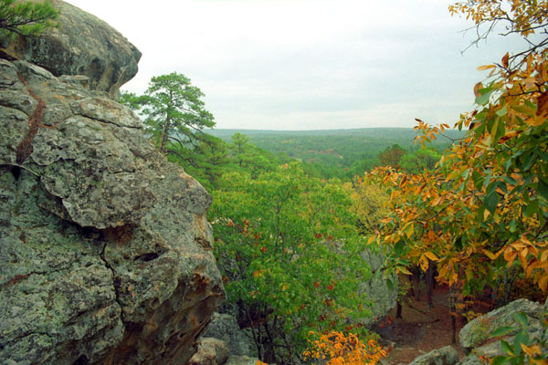
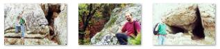
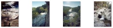
We had our site set up Thursday evening, and we took some walks around the area, but we did most of our hiking on Friday. There were a number of interesting trails, and we hiked almost all of them (save for those that wind through the level part of the forest and go around the park's three lakes). One trail took us by two or three "caves," although these were more large crevices in the rock cliffs than anything else.
|
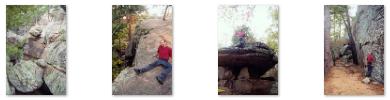
This trail took us through rock crevices where someone- perhaps the CCC- had taken the time to construct rock staircases. We spent half a day exploring as many of these crevices and "caves," and it was a great deal of fun climbing around on the exposed rock faces- all the while surrounded by forests beginning to show their Fall color. Click on the thumbnails below to see some of the pictures we took on these "cave" hikes:
|
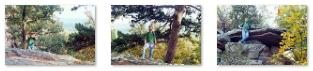
Some of the trails took you up on top of the various rock cliffs scattered throughout the park, and we did some of these trails in the afternoon. I always like climbing to the tops of things- as much for the view as for the fun of going down.
|
Click on the thumbnails below to see some other pictures we took on our hike to the top:
|
It was late afternoon before we got back from our last hike, but we had already decided to stay in the State Park for a second night, and so hadn't had to strike camp this morning. Fred did a good supper at the campsite, and we actually did another short hike the next morning, before heading off to Tulsa.
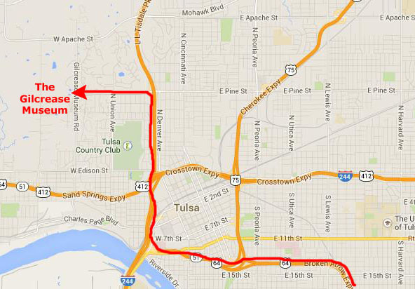
The Gilcrease Museum in Tulsa (10/28)
|
The Gilcrease Museum today houses the world's largest, most comprehensive collection of art of the American West as well as a growing collection of art and artifacts from Central and South America. The museum is named for Thomas Gilcrease, an oil man and avid art collector. It is quite similar, although a bit larger, than the Amon Carter Museum over in Fort Worth.
Thomas Gilcrease grew up in the Creek Nation, located within present day Oklahoma. At the turn of the 20th century the federal government distributed lands held by American Indian tribes to private citizens. His tribal membership entitled him to an allotment of 160 acres located south of Tulsa- land that subsequently became part of one of Oklahoma's major oil fields. Gilcrease proved to be an able businessman after founding the Gilcrease Oil Company in 1922, and he soon amassed a large fortune.
Gilcrease traveled extensively in Europe during the 1920s and 1930s, and his visits to European museums inspired him to create his own collection. Pride in his American Indian heritage and interest in the history of the American West provided the focus for that collecting.
|
Gilcrease collected at a time when few people were interested in the art or history of the American West, and so his collection grew rapidly. During the early 1950s, he acquired numerous works of art, artifacts, and documents. But declining oil prices made it difficult for him to finance major purchases. Faced with a seemingly insurmountable debt, Gilcrease offered to sell his entire collection in order to keep it intact. In 1954, fearing that the Gilcrease Museum would leave Tulsa, a small group of citizens organized a bond election. The voters of Tulsa approved, by a 3-to-1 margin, the bond issue that paid Gilcrease's outstanding debts. This kept the collection in the city.
Thomas Gilcrease deeded his collection to the city of Tulsa in 1955, and, in 1958, the Gilcrease Foundation conveyed the museum buildings and grounds to the city. In addition, Gilcrease committed oil property revenue to Tulsa for assistance in maintaining the museum until the $2.25 million bond was fully repaid. In the years following the transfer of the collection, Thomas Gilcrease continued to fund archaeological excavations and acquire additional materials for the collection. Upon his death in 1962, he bequeathed to the museum the material he had collected during his final years.
We learned about most of this history when we watched a film on the history of the Museum shortly after arriving; after the film, we spent the better part of the afternoon walking through the galleries. Photography was not allowed in the collections (as is the case in most museums), and so we have no pictures of the art and artifacts that we saw.
|
Thomas Gilcrease believed that the story of the American West could be told through art and that the history of the native Americans and his own American Indian heritage could be preserved through painting, sculpture, and other forms of art. He was a patron to a number of native American artists of his time and purchased over 500 paintings by 20th century native American artists alone. The Gilcrease Museum now has a new long-term native American exhibition. "Enduring Spirit: Native American Artistic Traditions" permits the museum to showcase some of the major strengths of the permanent collection as well as provide a much more comprehensive and integrated presentation of the museum's native American art collections.
On July 1, 2008 the University of Tulsa assumed management of the museum through a public-private partnership with the City of Tulsa.
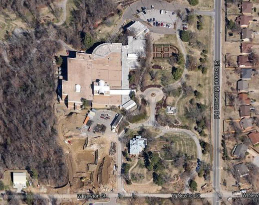
Using the Gilcrease collections as a guide, themed gardens have been developed on twenty-three of the museum's 460 acres. These gardens enhance the museum's collections by reflecting gardening styles and techniques from four time periods in the American West: Pre-Columbian, Pioneer, Colonial, Victorian, as well as a rock garden. Gilcrease is the only known art museum to have these educational and inspirational gardens on one site nestled in the Osage Hills. Being outside, we were able to take pictures, and we saw a number of beautiful sculpture works. Among these were:
|
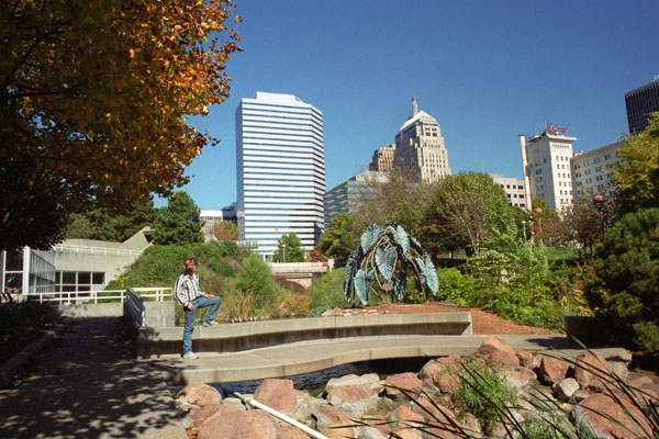
In the Gannaway Vista Garden, red, pink and white azaleas are intermingled with forsythia, dogwood and redbud to frame views of the Osage Hills. Burning bush provides scarlet foliage in autumn and the mature Southern magnolia offers winter greenery and early summer blooms. Nearby is Stuart Park; it has two small ponds (one of which we walked to and which you can see here).
|
|
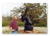
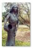
This iconic sculpture by the Native American artist stands at the entrance to the Gilcrease Museum. It has also been used as the official symbol on Oklahoma license plates.
|
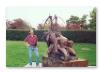
This sculpture was done by a member of Oklahoma's Potawatomi tribe. The artist, born in 1948, now works out of his studio in Colorado. The sculpture is in the Gillies Garden on the museum grounds.
|
Description.
|
Description.
It was late afternoon when we finished wandering through the gardens outside the Gilcrease Museum, so we hopped back into the car and headed down to Oklahoma City, checking into a motel in Moore, Oklahoma. (A little under 13 years later, we would drive through Moore again on our way to South Dakota, just a week after the town was devastated by one of the worst tornadoes in Oklahoma history.)
A Day in Oklahoma City (10/29)
|
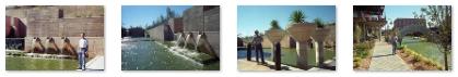
We also want to visit the city's botanical garden, which is also located downtown. The Myriad Gardens have a unique tubular building that contains the various greenhouses, and there are outside gardens as well.
If there is time remaining in the day (we will be driving back to Van Alstyne late this evening), we might also make a stop at the new Oklahoma City Riverwalk- an artificial creation in the southeast part of downtown. There is no actual river, but the city hopes to build an attraction built on the San Antonio model.
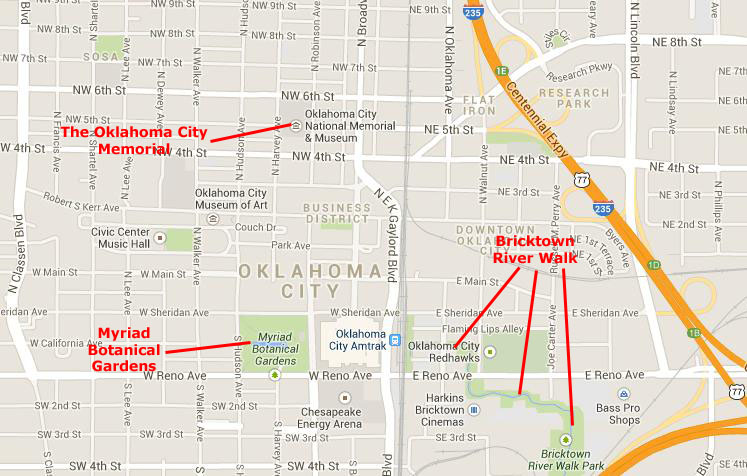
I've included a map of downtown Oklahoma City at left, and have marked our three stops on it so you can see where they are in relation to each other.
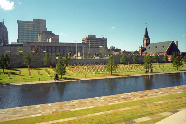
We began by driving to the Oklahoma City Memorial, parking about a block away to walk through the area.
The Oklahoma City National Memorial and Museum(10/29)
|
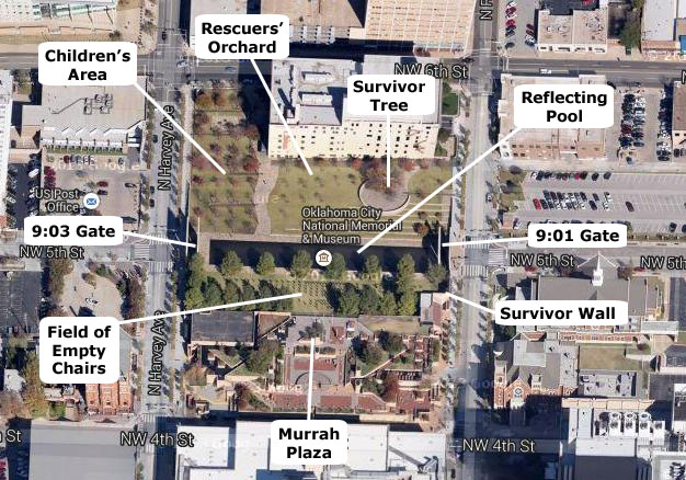
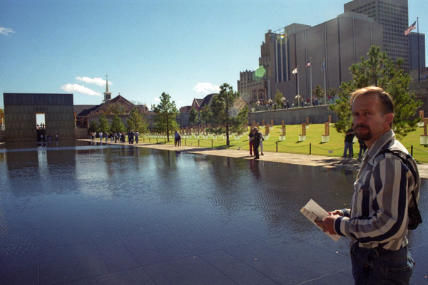
The central Reflecting Pool is a rectangle with its narrow ends on the east and west. At the west end of the pool, where we started, is The 9:03 Gate. That picture was actually taken from the other end of the Reflecting Pool, underneath a duplicate structure called The 9:01 Gate (seen here as we came up from street level to the plaza level of the Memorial). These monumental twin gates frame the moment of destruction– 9:02 a.m.– and mark the formal entrances to the Memorial. According to the design, "The East Gate represents 9:01 a.m. on April 19, and the innocence of the city before the attack. The West Gate represents 9:03 a.m., the moment we were changed forever, and the hope that came from the horror in the moments and days following the bombing."
When we came up from street level, we were on the plaza itself, and we could see all the elements of the design in one view. Looking towards The 9:01 Gate, on our right was the Field of Empty Chairs and the elevated Murrah Plaza and its overlook. At the far end of the Memorial, the Survivor Wall was just to the right of the gate opposite. On the left (north) side of the pool were the Survivor Tree, Rescuers' Orchard and the Children's Area.
|
(Be sure to look at the better view taken from the Murrah Plaza Overlook below.)
The 168 chairs represent the lives taken on April 19, 1995. They stand in nine rows to represent each floor of the building, and each chair bears the name of someone killed on that floor. Nineteen smaller chairs stand for the children. The field is located on the footprint of the Murrah Building.
At the corner of the Memorial, we went ahead up onto the Murrah Plaza. From the overlook, there was an even better view of the Field of Empty Chairs. Here on the Plaza there were benches and fountains, making it an excellent contemplative spot. Click on the thumbnail images below to see three pictures we took here on the Plaza:
 |
We stayed at the western end of the Memorial, and came back down from the Plaza to walk eastward along the south side of the Reflecting Pool. The pool occupies what was once N.W. Fifth Street. This element of the Memorial was described thusly in the proposal: "Here, a shallow depth of gently flowing water helps soothe wounds, with calming sounds providing a peaceful setting for quiet thoughts. The placid surface shows the reflection of someone changed forever by their visit to the Memorial."
|
We also took two more pictures of the Field of Empty Chairs from our vantage point by the south side of the Reflecting Pool, and you can click on the thumbnails below to have a look at them:
 |
We continued walking east, ascending to street level to the 9:01 Gate. As we came up to street level, we were standing by the Survivor Wall. The corner walls you see are the only remaining walls from the Murrah Building; they are a graphic reminder of the damage that was caused in the attack, and of those who survived. Today, more than 600 names are inscribed on salvaged pieces of granite from the Murrah Building lobby.
Passing by the 9:01 Gate as we walked north, we got an interesting view looking through that gate to the 9:03 Gate at the other end of the Memorial; you can see that view here. We continued around the north side of the Memorial, ascending to the terrace by the Survivor Tree. From here, there were inspiring views in all directions across the Memorial. We finished our tour by continuing west along the Reflecting Pool and back to the 9:03 Gate and our starting point.
The Memorial, I thought, was tasteful and contemplative, designed, on purpose or by accident, to minimize the noise of the many visitors who are almost always there. We did not go into the Museum, although I have read that it is interesting. I would expect that it would be much like my visit, many years ago, to the museum in Hiroshima, Japan, both memorializing, as they do, acts of extreme destruction.
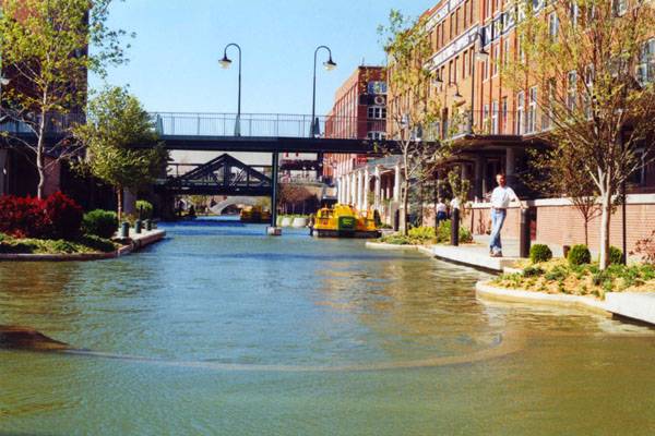
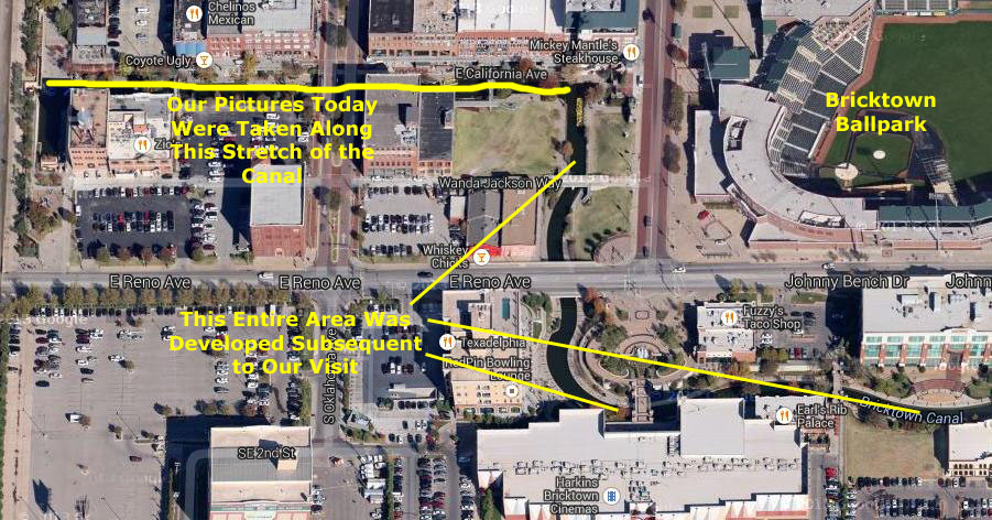
Bricktown: The Oklahoma City Riverwalk (10/29)
|
Four railroad companies had freight operations east of the Santa Fe tracks in what is now Bricktown in the late 19th and early 20th century. The first brick structures, which were typically only one or two stories, appeared between 1898 and 1903. Larger brick buildings were constructed between 1903 and 1911, and even taller ones after that. Working class houses were built nearby.
Oklahoma City's first black newspaper, the Black Dispatch, was located in Bricktown; it reported on the struggle to end racially segregated housing in the city. Also in that area was the first local chapter of the National Association for the Advancement of Colored People (NAACP). The decline of the area began with the onset of the Great Depression, while the growth of eastern suburbs and subsidized highways during and after World War II attracted many residents to newer housing. Railroads restructured and freight traffic moved to trucks and highways. By 1980, Bricktown had become a cluster of abandoned buildings.
In the 1990s, the mayor of Oklahoma City pursuaded residents to approve a series of tax incentives to lure new businesses, but these were not sufficient. But the mayor remained committed to a vibrant downtown for Oklahoma City; he and the Greater Oklahoma City Chamber of Commerce developed a plan to increase the range of activities and amenities to attract more residents and visitors.
|
At the moment, in 2000, the area is still in the beginning stages of development. (When we returned again in 2010 with our friends Mario and Steve, we found that a great deal had been done, and that the area had become quite popular.)
But you won't see many people in the pictures we took this year, since much of the development is still years into the future. Click on the thumbnails below to have a look at the pictures we took:
 |
The Myriad Botanical Garden (10/29)
|
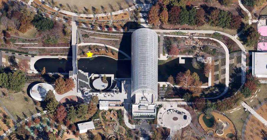
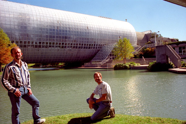
As you can see from the aerial view at left, the Conservatory is very, very unusual. It is, first of all, tubular, with glass arching over the plants, flowers and animals inside. Secondly, the tubular building is actually a bridge; the lake continues underneath the building, and small paddle boats can be rented allowing you to make the trip underneath the structure. (The large numbers of waterfowl do it for free.)
Of course, we couldn't see the structure from the air then (although I suppose aerial views were available somewhere, they weren't as accessible as they are now) but it was just as impressive from the ground.
|
In 1964, renowned architect I.M. Pei was commissioned to create a revitalization plan for downtown Oklahoma City; it was to include parkland for some sort of garden, and Pei’s original idea was to recreate the Tivoli Gardens of Copenhagen, Denmark. In 1970, the name Myriad Botanical Gardens was officially adopted. The name came from “the Myriad,” the new 13,000-seat arena and convention center across the street from the parkland.
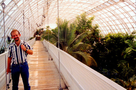
Seven years of planning followed, and on November 17, 1977, the Myriad Trust officially broke ground to begin construction of the Gardens. Construction of the Gardens’ infrastructure, including the base of the conservatory, water stage and other core facilities continued over the next four years as funding became available. In 1981, the Myriad Gardens Foundation was formed to raise private funds for the construction of the Crystal Bridge Tropical Conservatory; within a year they had raised $25 million in today's dollars. Completion of the Crystal Bridge Tropical Conservatory came in 1985, but it took another two years to plan, select and install the plant materials.
On March 25, 1988, the Crystal Bridge Tropical Conservatory opened its doors to the public- 12,000 of them in the first weekend.
|
As you can see in the picture at left, the gardens are indeed an oasis in the city- exactly what they were envisioned to be. Click on the thumbnails below to see some additional pictures we took before heading in to the Conservatory:
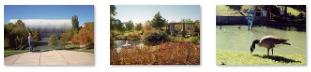 |
The entrance to the Conservatory is at the south end of the building, so we went around the end of the lake to get there. The Myriad is like other gardens; it offers memberships that provide free admission. These plans are usually a good deal for locals; that's why we have an Arboretum membership in Dallas. The tour through the Conservatory was well worth the $10 admission, but had we known then what we found out on our second visit to the Conservatory in 2010 with Mario and Steve, we could have gotten in free. As it turns out, many such gardens and arboretums join together to offer reciprocal member privileges, and our Arboretum cards would have gotten us a pass here. (Now we always ask; the Arboretum membership has gotten us free or heavily-discounted admission to four or five other gardens we've visited.)
|
Click on the thumbnails below to see some of the pictures we took of the flowers and plants on the main floor of the Conservatory:

|
We enjoyed our visit to the Gardens immensely, and hoped that we'd be able to come back again for another visit (which, as it turned out, we did). About four in the afternoon, we got in the car and began the trip back to Van Alstyne.
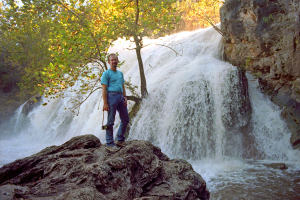
A Stop at Turner Falls (10/29)
|
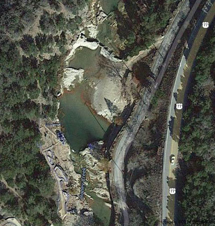
Mazeppa Thomas Turner, a Scottish immigrant farmer who married Laura Johnson, a Chickasaw woman, settled in the area in 1878 and discovered the falls. The falls were named for him.
Turner Falls, at 77 feet, is locally considered Oklahoma's tallest waterfall, although its height matches one in Natural Falls State Park. The falls are located on Honey Creek in the Arbuckle Mountains in south central Oklahoma, 6 miles south of Davis.
|
The city of Davis acquired the park in 1919 and operated it until 1950. It then leased the facility to other interests until 1978, when it resumed control. The park covers 1,500 acres, and also contains nature trails, caves and other interesting geological features. It also has a walk-in castle (closed for the season) which was built in the 1930s. Click on the thumbnails below to see some of the pictures we took here at Turner Falls:
 |
Even though it was late in the day, we stayed here at Turner Falls until it was too dark to take pictures. We did take quite a few, as this was our last stop of the weekend and we thought we'd might as well use up our rolls of film. Click on the thumbnails below to see more of the pictures we took here at Turner Falls:
 |
When our light faded, we left the falls, heading back down US 75 back to the Interstate and from there down towards Dallas. We took the highway east to Sherman-Denison, and had dinner in Sherman on the way back to Fred's house.
You can use the links below to continue to another photo album page.
|
November 19, 2000: My Birthday |
|
September 29-31, 2000: A Trip to Austin, Texas |
|
Return to the Index for 2000 |