|
February 10, 2005: Florida Trip Day 6 |
|
February 8, 2005: Florida Trip Day 4 |
|
Return to Main Index for Florida Pictures |
Driving to Key West
Getting Onto the Florida Keys
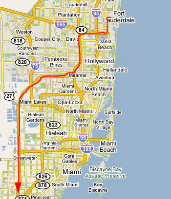 |
We got up fairly early this morning, and by nine o'clock were ready to head out. The first part of the drive is just to get down southwest of Miami. To do that, we just headed south on I-95 into North Miami, and then took one of the expressways that ring the city to the west to get down to Homestead, Florida.
This part of our route is shown at left.
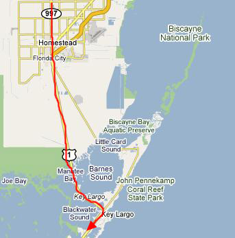 |
From Homestead, US-1 crosses the tip of Florida heading almost due south. As you go, the developed areas disappear and the land changes over to swamp and wetlands. The highway cuts a straight swathe through the low-lying swampland; it is two-lane and if you get behind something slow, you could be there for a while, as the highway is heavily-traveled. One saving grace is that every once in a while, there are passing lanes.
Between Manatee Bay and Key Largo, the highway crosses a series of short bridges over the water and you are then officially on the string of islands known as "the Keys."
 |
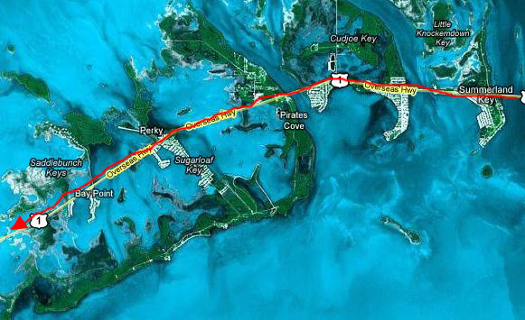
Down the Florida Keys to Seven Mile Bridge
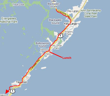 |
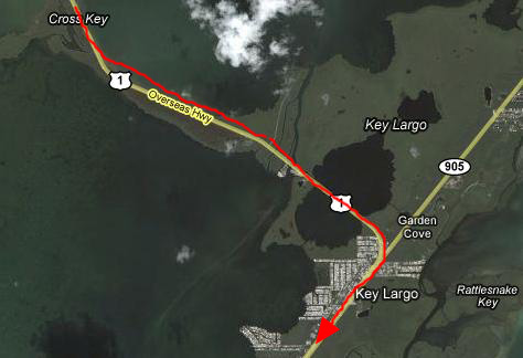
Going through Key Largo, you wouldn't really know you are on a key, since you can rarely see the water on either side from the highway. The highway itself is now a divided one, with two lanes in each direction, so travel is easier. On the other hand, the entire distance down to Newport is all built up, with lots of businesses on either side of the road, and consequently lots of traffic lights and traffic. But, all in all, things weren't too bad.
By the time we got down to the town of Newport, it was lunchtime, and we thought we should stop while there was a lot of stuff to choose from. We found a mom-and-pop diner alongside the highway, and so we stopped there. As it turned out, they were still serving breakfast, so that's what we had.
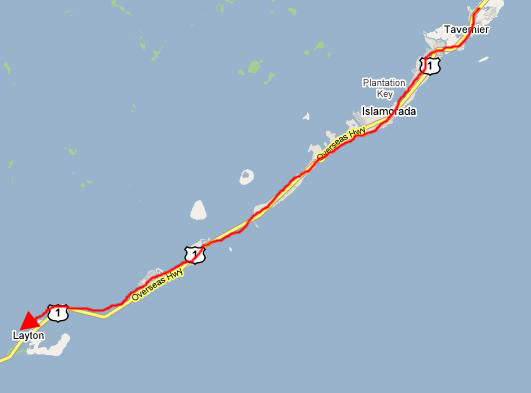 |
Islamorada is a very pretty area, and there are some new resort developments there. On both the Atlantic and the Gulf sides of the highway we could see new homes, most of them on stilts. It seemed like a very pleasant, if isolated, place to live.
Then we began a fairly long stretch (30 miles or so) of "key-hopping." I can't recall the names of all the keys and islands that the road crossed, and they aren't important anyway. A couple were fairly large and developed, but most were only a square mile or so in area. All were extremely beautiful, for now we had left the swampy area of the northern part of the Florida Keys far behind.
I took a couple of movies as we were driving towards Layton, FL. The first, and best, of them records our progress up onto a very typical bridge along the highway, and the open water on both sides. You can watch that movie using the left-hand player below. The other movie was the result of simply pointing the camera towards the Atlantic as we drove along only a few feet from the waves, and you can watch that movie using the right-hand player below:
|
|
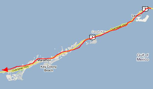 |
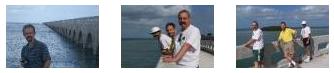
There was a little roadside rest here at Conch Key, so we pulled off the highway for a few minutes to take some pictures. Here is a picture of Joe and the bridge that we had just come off; you can see how straight some of them are (the bridge, not Joe). Fred also took a few pictures, including this one of me, Frank and Joe with the Gulf of Mexico and one of the tiny offshore islands in the background.
We continued on south through the rather large town of Marathon, Florida. You might think that the town's name derived in some way from the name for a 26-mile distance, and, in a way, you'd be right (as I found out from a quick read of a very interesting Internet site on the history of Marathon). The key on which Marathon sits had been known since Spanish colonial times as Key Vaca, and it was thusly named in maps and records (see next map). At the turn of the century, about 1900, the key saw a burst of activity as Henry Flagler, arguably the most famous name in Florida history and the man most credited with opening up south Florida, was building the precursor to the Florida East Coast Railway from Miami to Key West. He had fallen behind his schedule, and as a result the construction workers were constantly being exhorted to speed things up. Popular refrains from the workers were either "What is this, a marathon?" or "This is getting to be a real marathon!" Local lore has it that the word was heard so often that when the town was incorporated on Key Vaca (at the time being just a few buildings and a railroad station) the name stuck.
From Marathon, the highway continues southwestward to the next point of interest- the Seven Mile Bridge.
Little Duck Key and the Seven Mile Bridge
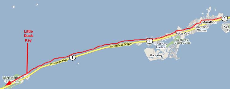 |
We marked it on the odometer; the bridge is indeed just over seven miles long, and when it next becomes a roadway on land one is on Little Duck Key- a very small island only a few acres in size. Here, there was another pulloff and a small park, so we stopped to take some pictures and movies.
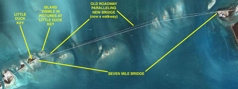 |
The Seven Mile Bridge is actually a replacement for an older bridge that you can see to the north of it (above it) in the photograph. This previous bridge was constructed in 1909-1912, and was then known as the "Knights Key Pigeon Key Moser Channel Pacet Channel Bridge," quite a mouthful no matter how you slice it. It was built under the direction of Henry Flagler as part of the Key West Extension of his Florida East Coast Railway, often known as the "Overseas Railroad." There was a swing span over Moser Channel to allow boat traffic through. In 1935, the Labor Day Hurricane severely damaged the bridge. In fact, this hurricane spelled the end of the Overseas Railroad; it was abandoned in that year. Some of the old railroad bridges are still visible today. This section of the railway was converted to an automobile bridge in the next two years, and still had a swing span at Pigeon Key. In 1960, hurricane Donna caused further damage, and the bridge's days were numbered. The present bridge was completed in 1982, but the old bridge was left in place to serve as a fishing pier and because it provided access to Pigeon Key. The swing span was removed, however, and so it is not possible to walk all the way across it from Marathon to Little Duck Key. The new bridge has a "hill" in the middle where it rises high enough to allow boat traffic underneath.
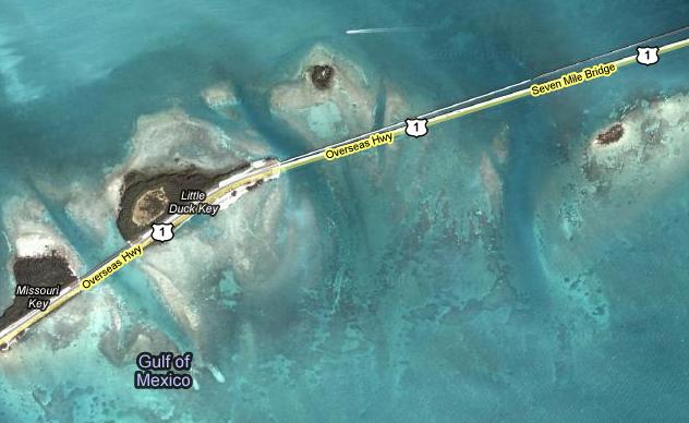 |
Obviously, what sticks up above the surface of the water is just the peak of a much larger island, most of which is submerged. But the islands themselves are still quite small, and there are channels of deeper water (ten feet or more) than run between them, these channels having been carved by the action of the tides and the storms that pass through.
You can also get a better view of Little Duck Key here.
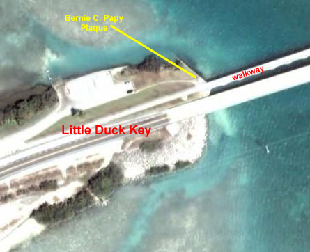 |
One of the first things we saw after parking the car and walking over to the older bridge was the dedication plaque for the Seven Mile Bridge. I thought that the name on the dedication plaque, "Bernie C. Papy," seemed so "country" and so "Florida" at the same time that I could not resist making a movie and reading the inscription on the plaque in my best Jawja accent. Have a chuckle and watch that movie using the player below:
|
|
|
|
Also in a humorous vein, I took another movie out on the pedestrian bridge, this one of a fishing competition, and you can watch it with the player below:
|
|
|
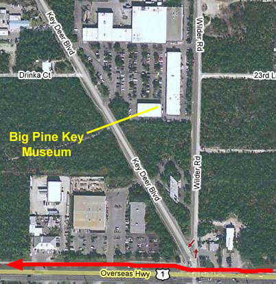
A Side Trip on Big Pine Key
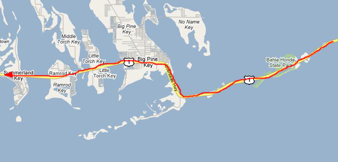 |
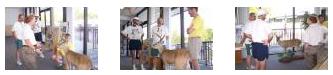
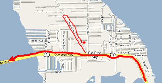
Somewhere, I forgot where, we had either seen a sign that mentioned the endangered Key Deer or perhaps Fred had found out about the animal elsewhere. But we had been told that there was a museum somewhere on Big Pine Key devoted to the Key Deer and other indigenous wildlife and flora. We all wanted to stop in.
 |
 |
|
Of course, the primary attraction of the small museum was the exhibit about the Key Deer. This tiny race of white-tailed deer is found only in the lower Florida Keys. Fully-grown, the Key deer stands just 30 inches at the shoulder- about the size of a large dog. The Key Deer inhabits pinelands and hardwood hammocks on Big Pine Key and a few surrounding keys where food, cover and fresh water are available year-round. It eats angroves, thatch palm, saw palmettos and acacia. An endangered species, its main threat today is loss of habitat. While the establishment of National Key Deer Refuge in 1954 helped protect a portion of the deer's vanishing habitat, increasing human population growth in the Keys means a slow, but steady decline in the deer herd.
There were other interesting exhibits that we looked at before we left, such as the Lower Keys Marsh Rabbit.
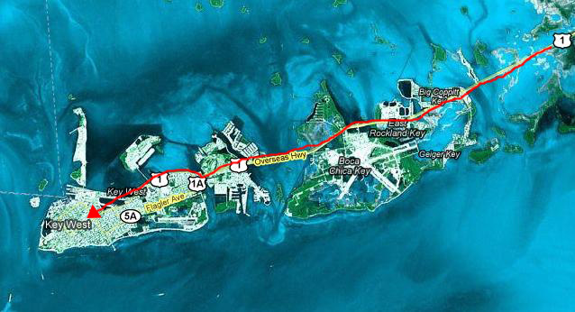
The Rest of the Drive to Key West
 |
 |
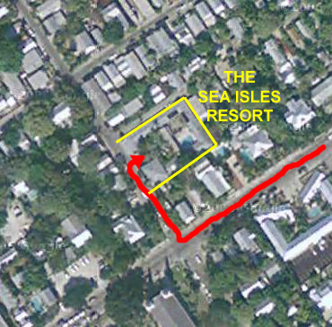 |
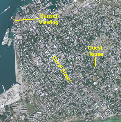
Walking Duval Street
 |
On the way down to Duval Street, Fred was furiously snapping away at the tropical foliage along the street- everywhere he looked there was something beautiful. I've put thumbnails for five of the floral pictures he took along the way; look at the full-size pictures by clicking on the thumbnails:
|
When we got down to Duval Street, we found ourselves at a corner standing underneath a huge hibiscus tree, and then a block down Duval we came to a curio shop that we had seen on our previous trip. It is distinctive because standing out in front of the shop is a mosaic car- an actual car that's been covered with mosaic tiles.
Walking down Duval towards the pier (actually northwest), we went in and out of numerous shops and saw quite a few interesting things. The street traffic was certainly distinctive, with these odd tiny cars jostling for space with bicycles and full-size vehicles and a great many pedicabs with their loads of tourists.
Fred took a couple of pictures of distinctive architecture, and you can see them here and here, and both Fred and I took snapshots of the rest of the group walking along the street. Fred took a picture of Joe, Frank and I and I snapped a picture of Fred and Frank.
Finally, just before we reached the pier along the northwest side of Key West, Fred found a little park with some interesting fountains.
Key West Harbor Sunset
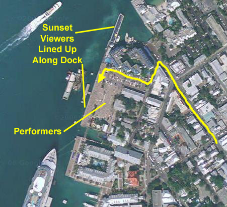 |
As you can see in the aerial view, the esplanade was quite expansive, and this evening it was filled with locals, tourists and vendors selling all manner of food, drink and souvenirs.
 |
There were also a goodly number of street performers. There were magicians, mentalists, singers and dancers and even a comedian. One of the best of the performers was a young girl who was twirling two chains that had burning fireballs at either end. In this picture, Fred has caught her having just got them all lit and preparing to twirl them about; take a look at that picture here. Once she got them going, then her act really got into high gear; it was reminiscent of one of the shows we saw at the luau in Hawaii a couple of years ago.
|
|
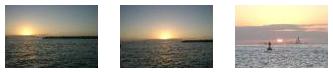
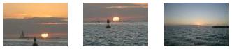
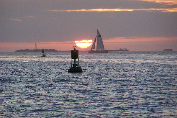
By this time, the sun was just setting, so we walked over to the edge of the dock to get a good look; we had to jostle a bit to get a good position for pictures. Here is a picture of part of the crowd watching the sunset. I've selected six of the best pictures of the actual sunset, some taken with a zoom some not. I have put thumbnails for these pictures below and you can look at the full-size pictures by clicking on the thumbnails.
|
|
|
You can use the links below to go to another album page.
|
February 10, 2005: Florida Trip Day 6 |
|
February 8, 2005: Florida Trip Day 4 |
|
Return to Main Index for Florida Pictures |