|
June 22, 2005: Palm Springs Trip Day 5 |
|
June 20, 2005: Palm Springs Trip Day 3 |
|
Return to Main Index for Palm Springs Pictures |
Thanks to the Agua Caliente Tribes
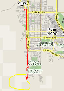
It's Tuesday, and Fred and I have planned to go off and do a bunch of canyon hikes on the Agua Caliente Indian Lands. I'll talk more about the hikes in just a minute, but first, I'd like to provide a little information about how these Indian lands came to be located here.
The Agua Caliente are members of a large Linguistic and cultural family of Native Americans known to ethnographers as: "Uto-Aztecan Stock". The family of "Shoshonean" stock includes other nearby Aboriginal neighbors such as: The Moapa Paiutes of Southern Nevada, the Chemehuevi along the Colorado River, the Tohono O'otam (Papago) along the Southern Part of Arizona and Northern Mexico and the Pima all the way down to Chihuahua Mexico as well as many other groups.
One thing that ties all of these groups together is, oddly enough, the Palm Tree. All of the Groups mentioned along with the Agua Caliente Cahuilla have been known to use the Washingtonia filifera or Desert Fan Palm- a native palm tree to the areas where these groups have traditionally lived for many centuries. Uses of these Palms in each of the mentioned groups is very similar or identical and includes basketry, food in the form of a mush type gravy and utensils and shelters. Most of the groups have at least some limited oral traditional mention of the Palm which has been handed down through the many generations. The agua Caliente bands have perhaps the most detailed oral traditions surrounding this native plant.
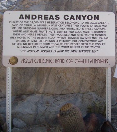
These palm trees were native to this particular area, growing mostly along the various streams that flowed down from the San Jacinto Mountains into the Coachella Valley, and because the palms were here that brought the Indians. The Agua Caliente Indians were industrious and creative with a reputation for independence, integrity and peace, They believed this productive land of their ancestors would always be theirs, but in 1876 the U.S. Federal Government deeded in trust, to the Agua Caliente people, 32,000 acres to be used as their homeland. At the same time they gave to the So. California Railroad, on either side of the railroad, ten miles of the odd sections of land to induce them to build the railroad. Of the reservation's 32,000 acres, some 6,700 lie within the Palm Springs city limits. The remaining even sections fan out across the desert and mountains in a checkerboard pattern.
In this the Agua Caliente Indians suffered a fate much like that of all other North American native Indian tribes; their land was simply taken when it became apparent that it could be put to economic use by the Anglo-Saxons and immigrants who comprised the peoples of the new and growing United States. When lands were not useful, the Indians were left to occupy them, but when their productive lands were taken and they were given less desirable lands as a result, their way of life was doomed. These are facts and trends that every schoolchild knows about.
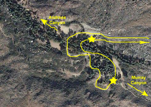
But in the Palm Springs area, things turned out a bit differently. The fact that the Palm Springs area is really a twentieth-century invention worked in favor of the Agua Caliente tribes. By the time that developers recognized the value of the Coachella Valley as a resort community, the Indian tribes had become more knowledgeable about turning the legal system to their favor. The Agua Caliente were able to foil the plans of developers to simply take their lands and give them undesirable parcels in exchange. Though Palm Springs and the surrounding area was described as a recreational oasis as early as the 1890's, the historical significance of the three southern canyons, as well as Tahquitz Canyon, is noted by their listing on the National Register of Historic Places, Palm and Andreas Canyons have the most and second most palm trees in the world, with Murray Canyon listed as fourth.
The Agua Caliente were able to retain control of their lands and, as has been done in Hawaii, realized that it would be in their best interests to lease much of their land rather than sell it. That is why much of Palm Springs and some of the other Desert Cities sit on land that is still, in actuality, owned by the Indian tribe, but merely leased, admittedly for long terms, to developers. And this is why the most important of the Indian lands, the sacred canyons and streams and stands of native palm have remained untouched. The Palm trees that are so ubiquitous in the cities of the valley were, for the most part, brought in and planted. The water used by the cities comes from the extensive underground aquifer; there has been no attempt to coopt the various streams that come down from the mountains.
And there is something else unusual about this area- there are few, if any, fences to keep you from simply parking along Palm Canyon Highway and just hiking off into the hills. The Indians who still own and control this land see it as a grant to them from a higher power but do not see that they have been mandated to keep everyone else off. They see the lands as belonging, at least insofar as use is concerned, to everyone. Every place else that Fred and I have gone in the West, all along the highways are miles and miles of fencing, since all the land is privately-owned (except for state and national parkland, of course). But there are no fences here, and that is one reason why there are so many trails and so many hiking opportunities.
But the hikes we want to do today ARE on lands that the Indians control day to day. But, even so, these lands are not fenced. All the Indians have done is to put an entrance station, much like those at national parks, at the highway leading to the various canyons. Anyone may visit, and anyone make use these lands, simply by paying a small fee. Once past the entrance station, one can drive to any of the canyons, park in the open areas near them, and then hike where and when they like. Visitors are simply cautioned that the canyons and springs and streams and palms must not be defaced and, I think a bit surprisingly, they are not. We hiked three canyons, and I do not recall seeing as much as a gum wrapper discarded on the ground. And we could go anywhere; for once there were no signs telling us where we might and might not go. It was a very different experience.
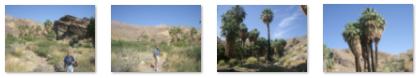
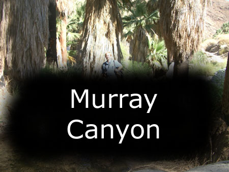
Murray Canyon Hike
 |
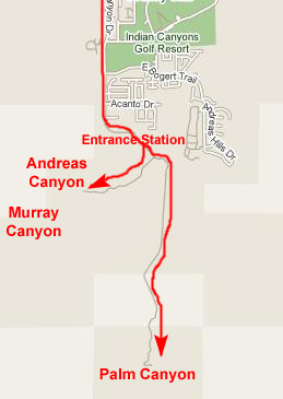 |
The entrance station was a very simple affair; all we had to do was pay our entrance fee, which I think was $10. For that, we could come and go as we pleased for three days, but all we needed would be today.
Once through the entrance station, the road forked, with the road ahead going to Palm Canyon and the road to the right going to both Murray and Andreas Canyons. We had no particular order for the hikes, so we simply turned off to head for Murray Canyon.
 |
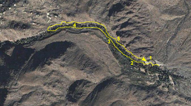
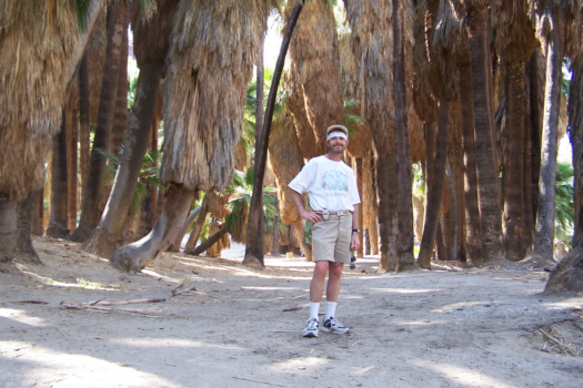
When we got to the parking area, we knew that the trail to Murray Canyon led off from the south part of the area, so that was the first place we parked. It was already getting warm, so I exchanged my polo shirt for a loose t-shirt and we headed off towards Murray Canyon.
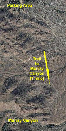 |
The trail to the actual beginning of Murray Canyon was actually about a mile or so. From far off, the canyon wasn't anything spectacular, just a grove of palm trees that we could see off in the distance. As we got closer, the grove got larger until finally we were on a hill overlooking a desert oasis.
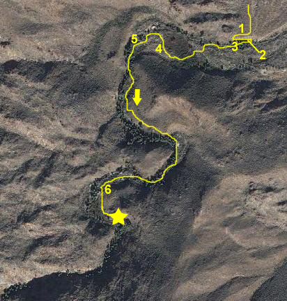 |
But to begin with, we found ourselves on a slope above the first oasis (point 1 on the aerial view). I took a movie of where we'd come from and where we were headed, and you can watch that movie using the player below:
|
|
|
|
The interior of the grove was cool and shady and a nice place to be; I enjoyed just standing in the grove and listening to the water bubble past. Meanwhile, out in the sunlight, Fred had found one of the local residents. We spent a few minutes in the grove just cooling off, and then began to follow the actual Murray Canyon trail back up the canyon. The trail took us out of the oasis, climbing up just a bit on the south side of the oasis (point 3). You can watch a movie of our progress along the trail by using the movie player below:
|
|
|
|
This process of walking along the stream for a ways, then having the trail rise out of the canyon and then back down to the stream would repeat itself all along our route through Murray Canyon. But the nice thing was that we were never out of sight or earshot of the stream- never more than twenty or thirty feet from it as a matter of fact.
Just about every time the trail came back to the stream, one or the other of us would pause to just enjoy the quiet beauty of the palms or the water- much like I am doing here and here.
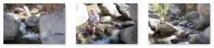
As I said, there were a few spots where the trail left the stream for a short time, and one of the first of these times was about at point 4. Here are thumbnails for some pictures of the trail and the palms taken along that stretch; to view the full-size image, just click on the thumbnail:
|
For the next hour or so, we just followed the Murray Canyon trail back up into the narrow, shallow canyon. Most of the time, we were in or beside the stream itself, but there were times when the trail climbed partway up the canyon wall- but never very high and always easy to follow.
|
To view the slideshow, just click on the image at left and I will open the slideshow in a new window. In the slideshow, you can use the little arrows in the lower corners of each image to move from one to the next, and the index numbers in the upper left of each image will tell you where you are in the series. When you are finished looking at the pictures, just close the popup window.
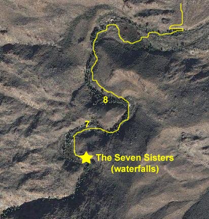
I also took a couple of movies on the way up to the Seven Sisters. One of them misidentifies the Seven Sisters; it was taken at a point in the canyon where I thought that the Seven Sisters were seven huge palm trees. You can watch this movie using the left-hand player below. The other movie is of a small waterfall that we encountered on our way up the canyon, and you can watch that movie with the right-hand player below:
|
|
 |
|
|
|
As I said earlier in today's narrative, one of the interesting things about these Indian lands is that they are not "developed;" they have been left untouched. There are no real trail markers, nor are there any signs except along the roads. So here, at the Seven Sisters, there were no restrictions on where we could walk or climb; we just knew that it was our responsibility not to damage anything (although it's hard to see how anyone might do that unintentionally).
|
|
I continued climbing up alongside the falls until I stopped next at an overlook high above the second set of falls. In this view looking down the waterfalls, you can see the two pools formed by the lowest two sets of falls. Looking off to the side, you can see the channel formed by more waterfalls, although it's hard to see the waterfalls themselves as they are fairly deep in the crevasse.
|
|
I got as high as I could with the time we had, high enough to get a view of the topmost waterfall of the Seven Sisters. And I was also able to get a good view looking up at the end of Murray Canyon.
I would like to have stayed longer here, climbing up further to see what I could see, but we had other hikes to do today, so, reluctantly, I climbed back down to rejoing Fred.
We started walking back down the canyon, again sometimes along the stream, sometimes not. We tried to follow a slightly different path so we could see more, and there were some very interesting things that we missed on the way up. For example, it wasn't very far below the Seven Sisters that we encountered a small field of these interesting flowers, something neither of us had seen before. A bit further on (point 7 on the aerial view above), as we were walking down the streambed, we found a natural bridge that we had missed on the way up.
|
|
As the movie indicates, to get to the cave you have to wade across the stream- or find someplace up- or down-stream where you can cross- and then seek out and enter the cave. Inside the cave, we found that most of the water in the stream falls through an opening in the "roof" of the cave, showering down into a pool below. Once in the cave, you can move around easily, and you can even get behind the shower and look out of the cave through its two major openings. It seems as if the cave was formed when part of the canyon wall collapsed, and the rocks happened to fall in such a way so that one large boulder formed a column that kept the other, larger boulders from falling flat into the stream. They are propped up, forming the cave.
|
|
But we had to keep heading back to the parking area, so we reluctantly left the shower cave and continued down the trail through Murray Canyon, often walking above the line of palms. Near the end of the canyon, I took a final movie here to try to show how the palm trees follow the stream as it curves through the canyon (point 9 on the aerial view). You can watch this movie with the player below:
|
|
Andreas Canyon Hike
 |
Once we arrived back at the parking area where we'd left the car, we moved it to the other side of the area where visitors to Andreas Canyon parked. I should point out that we seem to be the only visitors here this morning (which is perhaps not unusual as most visitors would not want to brave the heat of the summer season to visit these places).
 |
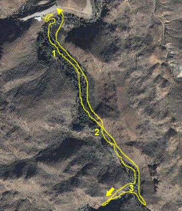
From there, the trail led down into the first grove of palm trees that marks the beginning of Andreas Canyon (#2 on the aerial view). There was a quiet pool in the grove, and a stream running through the grove much like the stream that ran through Murray Canyon.
I took two movies of the stream in this grove, and you can watch those movies using the movie players below:
|
|
As we continued up the canyon, rising slowly but steadily, we were following the stream, and, after a while, I couldn't resist taking my shoes off and stopping to dangle my feet in the water, which is were Fred caught me in his movies of the many little waterfalls along the Andreas Canyon stream. You can watch his movies with the two players below:
|
|
|
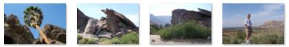
We walked up the streambed for about an hour, stopping frequently just to admire the view and listen to the stream. But we finally had to turn around so we could allow time for our third canyon hike, and we climbed up to the trail that ran along the canyon wall back to the parking area. Along the walk back, we passed some interesting rock formations and also got some good views looking back out of the canyon area towards Palm Springs. There are thumbnails below for the best of the pictures we took on the walk back; click on them to view the full-size images.
|
Once we reached the parking area we headed off immediately for Palm Canyon- our third and last canyon hike for today.
Palm Canyon Hike
|
Fifteen miles long, Palm Canyon is one of the great beauty spots in Western North America. Its indigenous flora and fauna, which the Cahuilla peoples so expertly used, and its abundant Washingtonia filifera (palm trees), are breathtaking contrasts to the stark, rocky gorges and barren desert lands beyond. A moderately graded, paved foot path winds down into the canyon for picnicking near the stream, meditating, exploring, hiking or horseback riding. Here at Palm Canyon, there was also a Trading Post, where we stopped to get a cold drink before our last hike.
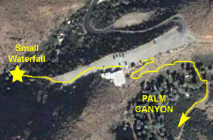 |
To get down into Palm Canyon, there is a switchback path that leads from behind the Trading Post down into the canyon. As soon as you get onto the trail heading down, you can see the tops of the many palms that are clustered at this end of the canyon, and as you get further down, there are views of the many palms stretching into the distance.
 |
The walk through Palm Canyon was very pleasant, and we took a number of pictures between points 1 and 2 on the aerial view. Here are thumbnails for a few of the best of them. To view the pictures, just click on the thumbnails:
|
|
|
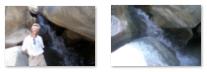
Here are a couple more views of this small waterfall; just click on the thumbnails to see the full-size images:
|
When I found that we could climb up above the waterfall and follow this new stream southwest, I called down to Fred and he climbed up to join me. What we found was a stream that was somewhat unlike the ones we'd already seen today; this one flowed through a sandy, rather than rocky area, and an area where there were relatively few palm trees. Just above the waterfall, here is a view of the stream looking up the canyon through which it flows.
This looked like another nice walk that we could take, so we spent the better part of an hour walking upstream. We found lots of reeds, something we hadn't seen before, as well as a few small waterfalls. There were also quite a few large boulders that had fallen into the streambed, and some of these formed little caves and overhangs that were fun to go into or climb on top of. I took some movies that I think show this side stream to good advantage, and you can view those movies using the two movie players below:
|
|
|
 |
But the time was getting on to late afternoon, and we realized that we'd have to soon turn around and return the way we came if we were to get back to Greg's in time for the dinner he was planning to cook.
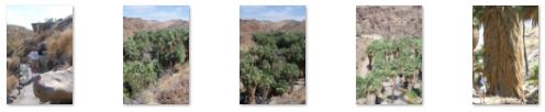
So we turned and walked back towards the trading post and parking area, taking our time to enjoy the cool shade of the giant palms. We passed the side canyon we'd explored, and eventually reached the switchback trail that led back up to the parking area. All along the way there were opportunities to take pictures focusing on the palm trees themselves, especially as we ascended the trail back to the parking area.
If you are interested in looking at the pictures we took of the palms, just click on any of the thumbnails below:
|
We got back to the car about four, and headed off back north out of the Indian lands, and then up Palm Canyon Drive and back to Greg's.
Dinner at Greg's
Tonight, Greg is cooking dinner for all of us, using the grill out back on the patio. There's not much to say about the evening, except that the dinner was excellent and we all spent some time planning the next day's outing to Disneyland.
Below are the thumbnails for some of the pictures we took of the evening; to view the full-size images, just click on the thumbnails:
|
You can use the links below to continue to another photo album page.
|
June 22, 2005: Palm Springs Trip Day 5 |
|
June 20, 2005: Palm Springs Trip Day 3 |
|
Return to Main Index for Palm Springs Pictures |