|
July 8, 2006: Devil's Tower, WY and Mt. Rushmore, SD |
 |
July 6, 2006: Two Medicine in Glacier NP, MT and Great Falls, MT |
 |
Return to Glacier National Park Trip Index |
Friday, July 7, 2006
Bozeman, Montana to Sheridan, Wyoming
To Hyalite Canyon
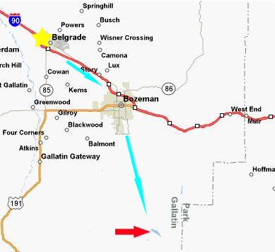 |
Our Super 8 Motel was actually in the town of Belgrade, Wyoming. We picked it because it was easier to get to, had high-speed Internet access, and cost a bit less than the hotels in closer to Bozeman. And since it was only a few miles away, it didn't really matter much.
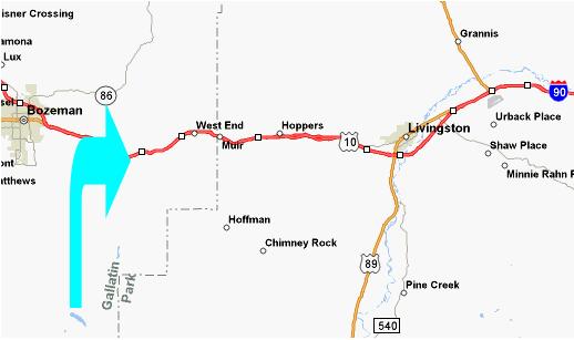
In the morning, our first task was to get to the trailhead for the Hyalite Canyon Trail. Hyalite Canyon, Reservoir and Peak are all south of Bozeman; of course you can see the peaks from the city itself. But there was no major highway that took us from I-90 to the canyon, so we really had to research the city map to find the best route there. As it turns out, Bozeman is a grid city just like most midwestern and western towns and cities, so finding our way was not difficult, but it did mean that we had to negotiate the morning rush hour traffic in Bozeman. (I've learned in all my travels that traffic snarls everywhere at rush hours; it doesn't have to be a big city.) So, we followed I-90 into Bozeman, got off at that exit on the map that is just north of the city center, and then headed south on one of the main drags to the south side of town. As it turned out, as we drove south, we passed the headquarters for the Montana State Parks system, and so we stopped in for some advice and maps.
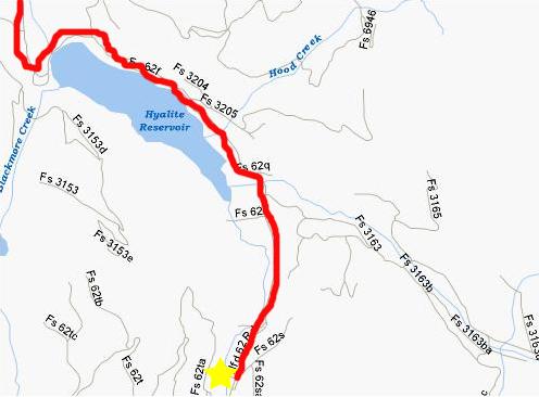
Then we continued south, zig-zagging through new suburban areas, until we came to Hyalite Reservoir Road, which took us directly to the Hyalite Resevoir in the Gallatin National Forest. I've marked the resevoir on the map with the red arrow. When the southern suburbs end and the area turns into rural farming land, the road starts climbing into the Gallatin National Forest, eventually coming out at the reservoir.
Once you cross the reservoir, the pavement ends, and things get a little tricky. The Internet said that you simply continue to follow the Forest Service Road 621 all the way to the trailhead- a distance of about five miles. As it turned out, the entire area was a complicated network of Forest Service roads, and the markings were not as clear or as frequent as a visitor from outside the area would need. Even though we'd checked Mapquest the night before, it didn't provide a great deal of detail, and the map shown here was about as good as we could do.
The road up from Bozeman comes in at the top left of the map above, and then crosses over the dam. Then it turns into Forest Service Road 621, which branches and curves and continues generally south until it ends at the Hyalite Creek Trail
trailhead.
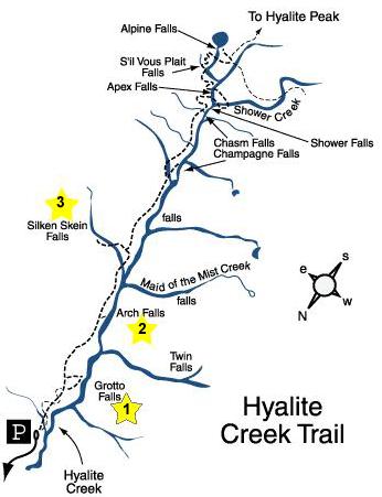
We finally did locate the parking area; there were five or six cars already there. There was a really good map of the trail system on the announcement board, and I was able to get a copy of it off the Internet. We knew from our investigations that the trail could be an all-day affair. After all, it goes by six or eight waterfalls, around a lake, and on up into the mountains to Hyalite Peak, covering ten miles and rising three thousand feet. It would have made a great place to spend an entire day, but we had our time already planned out for the rest of the trip, and so decided to visit only the first three or four waterfalls along the trail.
I've included and repeated a map below for each of the waterfalls we visited- Grotto Falls (#1), Arch Falls (#2) and Silken Skein Falls (#3). (We were going to do a fourth, but for reasons that only became a factor later, we decided to stop with three.) The only odd thing about the map is that north is at the bottom, so as we hiked from the trailhead parking area to the falls, we were heading generally south, away from the reservoir.
Hyalite Canyon Trail: Grotto Falls
We set off along the trail to our first stop at
Grotto Falls,
stop #1 on the map. The trail itself was pretty easy to this point. There are actually two trails to
Grotto Falls
and the two trails cross one another a couple of times. The reason is that one of the trails is accessible by wheelchairs or by people with disabilities. While they cannot actually get down to the base of the falls, they can get to a point from which there is an excellent view of them. I thought that this was very good of the State of Montana to do; it is not something that has been common in our travels.
The Grotto Falls area is quite beautiful, as I hope the movie I made of Grotto Falls will show you. You can watch it using the player at left.
Just below the falls, there is a tree that was either felled to cross the stream or which fell naturally, forming a bridge. I climbed up onto the tree and Fred took this shot of
me at Grotto Falls.
After looking around at the base of the falls for a bit, we climbed up the side of the cascade to get to the
top of Grotto Falls,
and we could get a good view of the water cascading down into the pool.
This was also a good place for me to shoot a movie of Grotto Falls to try to get across their beauty, and you can watch that movie using the player at right. Here is a picture of
me atop of Grotto Falls.
Grotto Falls, of course, are one of the many waterfalls along the length of
Hyalite Creek,
and this is the stream we are following all along the trail.
Fred went back down to the base of the falls the way we had come up, but I went upstream just a short ways until I could find a way to cross, and then went back down the far side of the stream until I could find a perch above
Grotto Falls
on the
far side of the creek.
On his way back down, Fred also took a picture of
the grotto
that gives Grotto Falls its name. Meanwhile, from my vantage point on the far side of the falls, I could get a good shot of
Fred beside the Grotto Falls pool
as he was looking up at me. Climbing down to the level of the pool, I could get some different pictures from this different angle, of
Grotto Falls
and
the grotto
itself.
I took one more movie of the falls and grotto from my vantage point on this side of the falls, and you can watch this movie using the player at left.
Getting back to the other side of the stream to hook back up with Fred required that I cross the log bridge. It looked easier than it was, because the top of the log had been worn smooth by all the people who've crossed it. So, discretion being the better part of valor, I walked only partway across it, then scooted on my butt the rest of the way. Fred got a movie of me doing so, but I'm certainly not going to embarrass myself by including it here! We walked back up to the main trail, and headed off for our next stop.
Hyalite Canyon Trail: Arch Falls
Hiking to the next set of falls took a half-hour or so on the trail that wound its way through the shady woods. The hike itself was a very pleasant one. It was pleasantly warm; there seemed to be more and more clouds the further we went up the trail. But, after a time, we arrived at
Arch Falls,
which is stop #2 on the map.
When the trail arrives at the falls, it is at about the level of the top of the falls, rather than the pool below them. There didn't seem to be a good way to get down to the pool, so we did our picture-taking from the top of the falls. The only good way to really show you Arch Falls (and why they are called "Arch" Falls), is through a movie that shows the structure of Arch Falls. Watch that movie by activating the player below:
It was really pretty amazing how the
natural bridge
had been formed; I can only assume that at some point the face of a normal set of falls got eaten away underneath somehow, and then the rock face sagged down until the rock arch was wedged against both sides of the small canyon.
Here are a couple more pictures taken at Arch Falls. First, Fred caught
me making my movie,
and I took a picture from the top of Arch Falls
looking down the canyon
formed by Hyalite Creek.
Hyalite Canyon Trail: Silken Skein Falls
Getting to Silken Skein falls was quite an adventure. We began by hiking another 30 minutes up the
Hyalite Creek trail
to a short side trail that leads off up the mountainside to Silken Skein Falls. The turnoff was marked, and, for a ways, the trail was easy to follow. But then the forest floor started clearing out of underbrush and such, making the trail more difficult to follow. It looked as if you could go any which way. The only saving grace was that we could hear faintly (and sometimes see) the falls ahead of us by the cliff face, and of course we could always tell which way was up. We could also hear the shouts of a group of kids who were already at the falls and who we passed on the way up without ever seeing them. We called out to them a couple of times for trail guidance, but basically just followed their voices. We weren't in much danger of getting lost, though, since the cliff face was always in view. What we finally did was just take the best path we could up to the
cliff face
(a portion of which had collapsed off to our left), and then we
followed the cliff face
around until we arrived at
Silken Skein Falls
(stop #3 on the map).
While the falls were really pretty, the valley panorama was equally beautiful, as I hope the movie I made of the valley panorama shows you. Watch it using the player at left.
Silken Skein Falls
is formed by a very small creek or spring and the water flows not over a sharp precipice, but rather down a series of
sloped rock faces
that spread the water out and form a wide, thin waterfall- just like a skein of cloth. As you can see,
the falls
don't seem to be particularly high right here, although looking up at them we wondered if there were more cascades up above, and maybe a better vantage point for some pictures or movies.
Looking around the falls, we found a
small canyon
that seemed as if it might offer a way up. We walked a hundred feet or so up this canyon until we could see the
back wall
of it ahead. Fred stayed where we had been, and I went ahead a bit to scout about to see if there was a way up. Fred caught a picture
me at the head of the canyon,
trying to find a way forward. Perhaps I might have found one, perhaps not. The rock faces were pretty bare in most places, so whatever path I might have found would have been tricky. But what really kept us from going much further was the fact that we had started hearing thunder off in the distance a little while ago, and now it seemed as if it were getting closer and louder as the clouds got a bit thicker. We decided that if it were going to rain, it would be better if we were not trying to slide our way back down to the main trail, so we decided to head on back. Before I left the canyon, I took a picture of the view from the
canyon to the valley,
and you can see Fred way down in the middle of the picture.
I scrambled back down to meet Fred, who'd discovered the stream below the falls, so I took a movie of the stream and falls, and you can watch that movie using the player at right.
From this same vantage point, I was also able to get a good
side view of Silken Skein Falls.
Then we headed back down the mountainside to the main trail. Getting down was a good deal more straightforward than getting up, so we found the side trail pretty quickly. Once back on the main trail, we had a decision to make. We could go further and see more waterfalls, but the downsides would be that the weather was very threatening (and indeed it was beginning to rain very lightly) and we did have a lot more that we wanted to do today. Also, we did need to be quite a ways down the road by nightfall to position us for our trip to Devil's Tower tomorrow. For these reasons we decided to move quickly back down the trail to the parking area. It was touch and go for a while, with us thinking that any minute we get a downpour, but it never materialized. We had gentle sprinkles for 45 minutes or so, and then the rain stopped, although it stayed cloudy. By the time we got back to the car, the clouds had begun to break up a bit, and it appeared as if we had dodged a rain event. Perhaps it's like a lot of places, where the higher up in the mountains you go, the more likely it is that it will be cloudy and wet. We certainly found that true years ago at Mt. Rainier and in Canada. In any event, we saw some really neat water features and we enjoyed the hiking. This would be another place, though, to return to sometime.
Palisade Falls
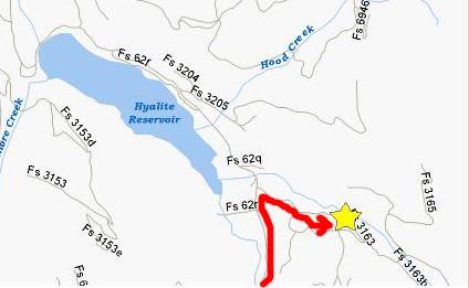
When we returned to the car from the Hyalite Creek Trail, we decided to stop and get something to eat for lunch. Then we had to retrace our route back down the Forest Service road for about three miles until we found the road that would lead us to Palisade Falls.
I thought we'd made a wrong turn, but we did find the right road to lead us to the
trailhead
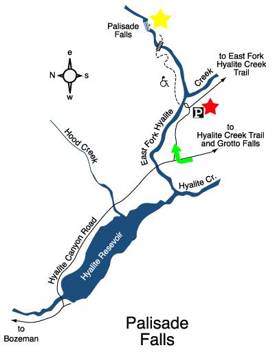
for the relatively short Palisade Falls Trail. The trailhead is marked on the map by the red star.
After and easy hike of about twenty minutes, we arrived at Palisade Falls. Watch the first movie I made of the falls using the player below:
The
trail
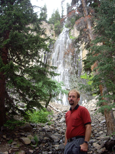
itself led right up to the base of the falls to a small sitting area (marked on the map with the yellow star); this hike, too, was wheelchair accessible, at least to this point that offers good views of the falls and which was an excellent place to use the falls as a backdrop for pictures of
myself
and Fred.
Palisade Falls
are quite beautiful, but not the spectacular falls that take your breath away. As you can see, the falls are more of a
cascade,
with a small volume of water spilling over the edge of the cliff face and then cascading down the sloping rock face of the cliff. Even so,
Palidade Falls
had its own beauty and its own attraction. One interesting thing about these falls was the composition of the cliff face over which the water cascaded. In this picture of just the
cliff face,
you can see that the rocks seem actually to be composed of vertical, hexagonal "crystals," although of course these aren't crystals in the classic sense. When the rocks fracture, we could tell from the pieces at the base of the cliff that they fractured along these same lines. I recalled seeing this same kind of formation in the pictures of Devil's Tower that I have seen, and wondered if the same rock formation we are seeing here extends all the way into eastern Wyoming where Devil's Tower is. There were no signs to tell us, but I thought that when we got to Devil's Tower, where there would likely be a ranger station, I might ask someone.
Both of us went over to the base of the falls from which we could get a good view
looking up
at the water cascading down. Then we climbed up a ways along the cliff face (the boulders strewn around made the climbing easy) to a point where we could see the water cascading into the
small pool
at the base of the falls. From here, a small creek winds its way back along the path, eventually, I suppose, to flow into the reservoir. A little further along the cliff face, there seemed to be a small
crevasse,
higher up, that might offer good views of the falls and the valley. So once the people who where already there moved off, I climbed along the rocks to stand in that "alcove." As I hoped, the views from the alcove were very good, allowing a great
side view of Palisade Falls
as well as a wonderful view out towards the
Hyalite Reservoir.
As I was coming down from my perch, Fred asked me to add perspective to his picture of another
cave‑like formation
that he had found in the cliff face. With me inside, you can get a good idea of how big the "cave" was.
It was getting on towards late afternoon (although due to the time of year there were still quite a few hours of daylight left), so we hopped back in the SUV and headed off back through Bozeman (and a quick stop at the local Baskin-Robbins) to I-90, and then on eastward to our last stop of the day- Natural Bridge State Park.
Natural Bridge State Park
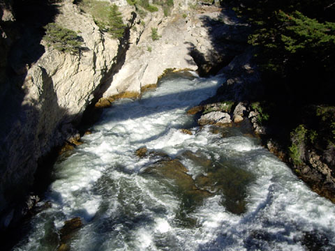
Our hikes in the Hyalite Canyon were done. There were more that we could have seen, but time was fleeting. Going back through Bozeman, we headed east on I-90. Just before Livingston, we crossed US Highway 89. Five days before, if we'd decided to go through Yellowstone NP on our way to Glacier, this is the road we would have taken to intersect with I-90. As it was, we simply continued on past Livingston on I-90.
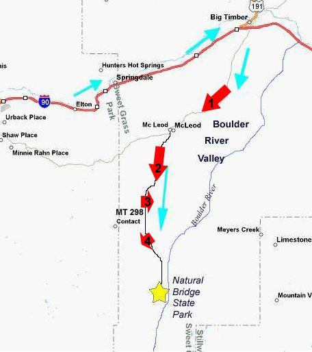
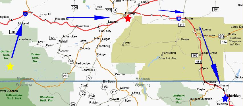
Leaving Hyalite Canyon, we had about a 2-hour drive to our next point of interest. We went back through Bozeman and hooked up with I-90 again, and then headed east, through Elton and Springdale towards Big Timber, Montana (see map). At Big Timber, MT, we got off the interstate and followed US191 into the center of the picturesque town, then turned south on McLeod Street which became Montana 298 to McLeod.
Driving through the Boulder River Valley, we followed one of the most pleasant and picturesque stretches of road on the entire trip (viewpoint #1). Watch my movie of a part of our drive along this scenic highway using the player below:
While the scenery wasn't as spectacular as someplace like Glacier National Park, there were people living here in an environment that seemed close to ideal- fertile land with hills for variety, a river and the beautiful mountains just a short distance away. Since that day, I have imagined chucking city life and moving to a place like that. Sure, the winters are probably a pain sometimes, but the independent, uncrowded life seems really attractive. Make some close friends nearby or in Big Timber, and life would seem pretty much ideal. It was, and continues to be, a very pleasant prospect. Maybe one day...
Driving through McLeod, a very small, very neat little town, we couldn't resist recording the
Roadkill Bar and Cafe
for posterity.
Driving south of McLeod, the scenery continued to be beautiful as the land slowly rose (viewpoint #2). Watch the movie I made of our progress along this stretch of highway using the player at left. The highway seemed to hug the western side of the valley, for the most part, leaving
broad stretches of fertile land
between the road and the Boulder River (viewpoint #3). The road continued through the beautiful valley, winding past the town of Contact. As the valley narrowed, the road moved further out into the valley, and now there were farms on both sides of the road, most of them
growing hay
(viewpoint #4). After a total of about 25 miles from Big Timber, the road takes you into Natural Bridge State Park.
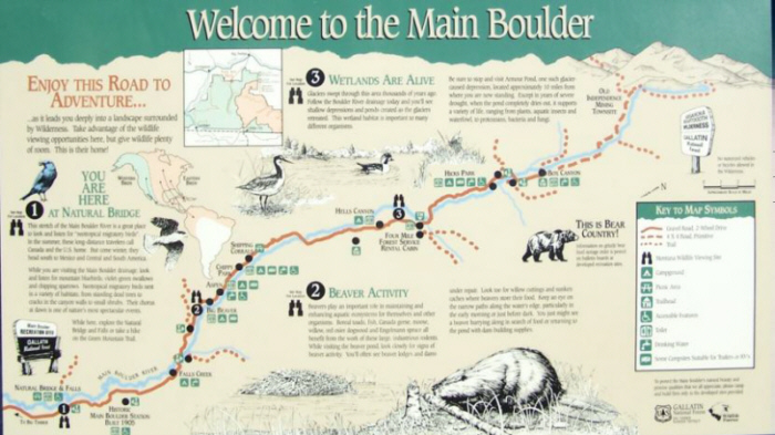
When we entered the State Park, we were just at point #1 on the park map shown here. While the Natural Bridge Falls are just inside the park, it continues for quite some ways, and there is a lot to see here.
We are just at the beginning of the Main Boulder Wilderness, and you can see that there are many campgrounds and things here, all the way back to the end of the road at the abandoned town of Independence, Montana. I think this area would be a good destination for another trip sometime. As you can tell from some of the pictures, we are in a mountainous area and there should be lots of great hiking and there are, of course, other waterfalls and features to investigate. Maybe one day we can get back here and camp for a few days. On this trip, though, our objective was to see the Boulder River Falls.
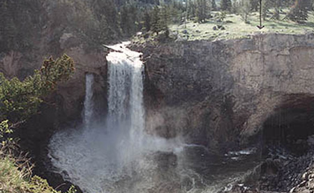
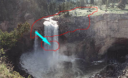
Natural Bridge Falls are unique as far as our own hiking history is concerned. They are the only falls which, during our adult lifetimes, have disappeared. The picture at right shows the falls as they existed up until 1988. They were a pretty normal set of falls, although they included a small hole in the cliff face through which a small portion of the water in the Main Boulder River poured; most of the water went on over the precipice. So, this is what we would have seen had we been here 20 years ago.
In 1988, about 100 linear feet of the rock river bottom at the edge of the precipice collapsed and sank. I've indicated this area by the large red shape drawn on the picture of the old falls. As this huge chunk of rock sank, its width jammed it against the rock walls of the canyon on either side, and so the top of the rock (which had been the bottom of the stream) stopped in place, instead of collapsing completely and revealing a new precipice with huge boulders below it. Imagine Niagara Falls, if you will. That is exactly what happened (and continues to happen) there at at most waterfalls. As the water flows over the falls, century after century, the ledge is worn away and "moves" upstream. Most of the time, the falls appear the same, just further and further back. (Of course, in our lifetimes, this process is far, far too slow to be noticed or even accurately measured. But it is happening.) But here, something much more unusual happened. As I said, when the precipice here collapsed, it did not collapse completely- it just sank and stopped, approximately twenty feet lower. Upstream, this created a narrow channel that rapidly descended those twenty feet. At the precipice, though, the small hole that had existed was made much, much wider (probably because of natural spaces in the rock under the old falls)- so wide, in fact, that the entire volume of the river flow (except, we are told, at times of high flood) goes through it. The opening also shifted downward and to the right in the picture, and now, the new outlet for the water is about as big as the smaller red circle that I've drawn. This may not be quite clear yet, but I think you will find the movies and pictures illustrate what happened quite well.
Upstream from the new falls, a
new bridge
has been constructed across the Main Boulder River, and it is from here that you can get excellent views of the new falls. First, let's take a look at a movie that will illustrate how the Main Boulder River now disappears under the rock; use the left-hand player below. And, while we are here, let's take a different look at the disappearing river by watching a movie with the right-hand player below:
Here are two more views of the Main Boulder River taken from the bridge- one is a still shot of the water flowing towards the sinkhole and the other is a movie taken from about the same position:
|
|
|
(Mouseover Image if Video Controls Not Visible) |
Then, from a
different overlook,
let's take a look at a movie of the bridge and the river (using the player at right). Also, here is a view of the Main Boulder River
looking upstream from the bridge.
The result is that, almost all the time, the Boulder River Falls are gone completely, replaced by the new Natural Bridge Falls. I found all of this incredibly interesting and something unique in all our travels. It was too bad that there was no way down to the old riverbed, since if you could get down there, you could walk across a riverbed that has been underwater for ages, since the river has dropped to flow UNDER you and then out the opening downstream. So now let's walk around to the downstream side of the falls and get a look at where all this water goes.
All the bridges and trails and
overlooks
here are new, obviously, since this attraction was just formed about fifteen years ago. In fact, while we were here, a couple of workers were grading for new walkways to take visitors to the new overlooks. Well-build trails take you to both sides of the canyon and you can get great views. We crossed the bridge and then hiked down the new trail on the other side until we came to the overlook where all questions were answered.
From the vantage point of an overlook down this trail, I could make a movie to show you where the water comes out; use the player at left to watch it. This was really an incredible sight, and it was hard not to photograph the heck out of it. After all, we had never heard of such a natural feature, and certainly have seen nothing quite like it on the trip. So, here is a picture of
me at the overlook,
a picture of the water outlet taken
through the trees
and an artistic shot of the
water outlet with sundogs.
We walked down to the final overlook, which was still under construction, so that we could get a good view of the Main Boulder River
looking downstream below the falls.
There was only one bridge across the river, so to get back to the other side, we had to walk back up along the river and over the bridge. We noticed one more overlook we had missed, and it was one that gave another, different view of the
disappearing river.
With the light fading, we had to say goodbye to the new Natural Bridge Falls, and get on down the road. We headed back up the highway to Big Timber. When we passed the Roadkill Bar and Cafe, people were dining alfresco, and it looked very inviting, but we had a long way to go yet, and driving at night on a full stomach is a recipe for sleepiness.
We reached the interstate back at Big Timber, and drove east (retracing our path from four days earlier) to have dinner in Billings, MT. We continued east and then south on the interstate to our Super 8 Motel in Sheridan, WY. As we left Montana, we had an odd thought. We'd been in the state for six days, and driven some 2000-2500 miles here. With the exception of a city police car in Missoula and one in Billings, we never saw any patrol cars at all. The nominal speed limit, even on two-lane roads, was 75, but there were stretches of 50 and 60 miles at a time without a single speed limit sign. We cruised at 80, but were frequently passed. Not once did we see anyone stopped, something that frequently happens in Texas.
We tumbled into bed in Sheridan, and I was looking forward to a Close Encounter of the Third Kind the next day.
Today's Flora
To see a full-size picture of any item, please click on the thumbnail:
|
(Click on Thumbnails to View) |
You can use the links below to continue to another photo album page.
|
July 8, 2006: Devil's Tower, WY and Mt. Rushmore, SD |
|
July 6, 2006: Two Medicine in Glacier NP, MT and Great Falls, MT |
|
Return to Glacier National Park Trip Index |