


|
November 9, 2007: Georgia/North Carolina Trip Day 7 |
|
November 7, 2007: Georgia/North Carolina Trip Day 5 |
|
Return to Main Index for Georgia/North Carolina Trip |
|
|
Touring the Alamance Battleground
 |
Battlefield Orientation
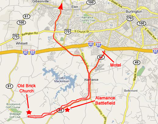
To get to the battlefield, we just took the same road that our hotel was on and head south and then west. After about ten miles, we came across the battlefield site.
 |
Markers and Monuments
 |
The term "Regulators" has a cloudy provenance; most references seem to indicate that the name was taken to express the fact that the backcountrymen who joined the movement were not opposed to the hegemony of the English Crown, but thought that the "regulations" that were imposed were imposed unjustly. For example, they could not understand why Governor Tryon needed a palance in New Bern while the backcountrymen could hardly make ends meet after paying their taxes and fees.
So, the "Regulator Movement," as it was called, was not a movement in opposition to the Crown, as was the American Revolution, but rather a movement that was attempting to even out the application of the rules and regulations to everyone- rules and regulations that the backcountrymen actually saw as necessary for the most part. So one can't really say that the Regulators were fighting for independence; rather, they were fighting for fairness- at least as they saw it. How the Crown saw it, we don't really know.
But, to make a long story short, Governor Tryon eventually found that he had to face the Regulators and defeat them or lose operational control over his colony. He gathered a militia, composed about half and half of English soldiers and local colonists, marched from New Bern to Alamance (about 150 miles) and engaged the Regulators in the area defined by the aerial view above. There were battlefield errors made on both sides, but the end result was that Governor Tryon carried the day. The Regulator Movement was effectively ended that day, although a rather different movement was already underway that would reverse that victory some ten years later.
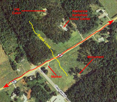
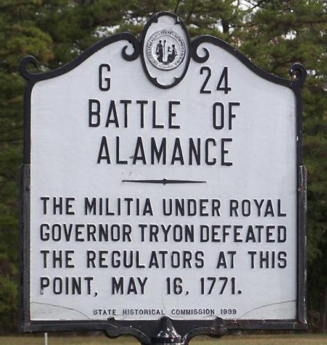
The first thing we did when we got to the battlefield area was stop at the roadside marker that described a little bit of the history of the conflict as well as the battle itself. This marker was located on the south side of the highway a bit beyond the entry to the visitor center.
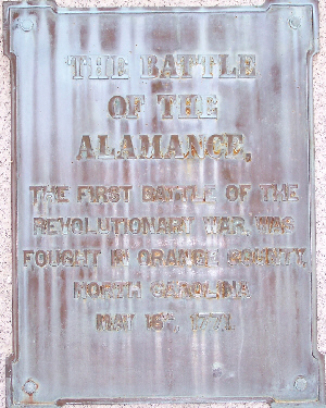
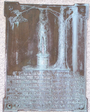
Out in the open field beyond the descriptive marker were two monuments. One monument, shown was solely for the Battle of Alamance, while the other, more elaborate monument dealt with the repercussions of this battle on the broader canvas of the Revolutionary War.
 |
 |
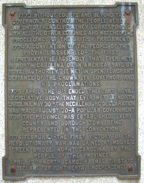 |
1773
Without courts and beyond the Governor's contro, the people were a law unto themselves. The corresponded with all the other colonies and watched the proceedings of the British Parliament.
1774
A convention of the people of the province assembled- "The first representative assembly that ever met in North Carolina or in America, save by Royal authority." it met in open, flagrant defiance of the Crown, its Governor, and his proclamations.
1775 April the 8th
Ended the last royal legislative body that ever met in North Carolina.
1775 May the 20th
The Mecklenburg Declaration was made.
1775 August the 20th
A popular government for the province was established, "every county and borough town being represented in the convention."
1776 February
The first victory of the Revolutionary War was gained at Moore's Creek bridge, North Carolina, by the people of the province.
1776 April 12th
North Carolina was first to declare for Continental independence.
The Visitor Center
|
The patio outside had a descriptive marker detailing the skirmish that occurred here, and the patio commanded an excellent view of the battlefield.
It was really a pleasure to listen to our guide, Bill Thompson, and ask him questions, and I think that the movie I made of a just a small part of his explanations out on the patio overlooking the battlefield will show you why. Please have a look at that movie using the player below:
|
|
The John Allen Cabin
|
|
|
|
Both Fred and I took quite a few pictures inside and outside the cabin, and I've selected four of his and four of mine to include in this album. To view the full-size pictures, just click on the thumbnails that I've provided below:
|
The Battlefield
When we finished at the John Allen cabin, we walked out into the battlefield itself to see if we could pick out some of the features that our guide had been talking about. To help us, the park has put up red and blue flags to indicate where the lines of men had been. One prominent feature described in accounts of the time was the big boulder which served as the point where such negotiations as occurred were carried on. Our guide also pointed out that the British regulars were taken aback at the ungentlemanly way that the colonists fought. Instead of forming in neat lines, out in the open, they had the bad form to hide behind trees and such- very unprofessional.
We went back into the visitor center to look at some of the exhibits, buy a DVD for my sister and thank our guide. One of the local sites that he had mentioned was the Old Brick Church that figured into many of the accounts, and we decided to set off to see it.
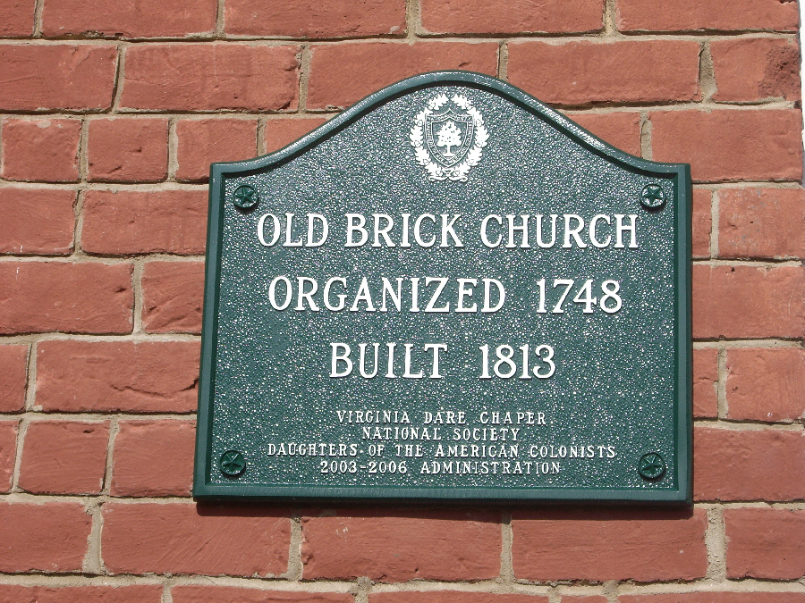
A Visit to The Old Brick Church
|
 |
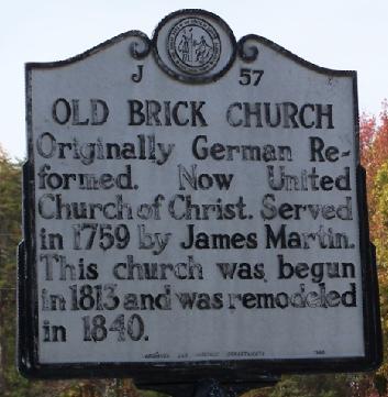
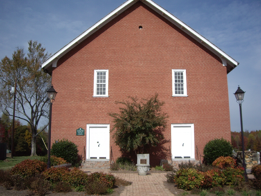
The church building itself was not constructed until the early 1800s, although the building that is on the site now is the restored church, the restoration having been done in the late 1990s. The church, however, and by that one means the actual fellowship, has been in operation since the mid-1700s, and thus the group was in operation at the time of the Alamance conflict.
The church is a plain brick building, and we took a number of pictures of it and the historical plaques on it, and I have put thumbnails for the best of these below. To see the full-size pictures, just click on these thumbnails:
 |
 |
 |
 |
 |
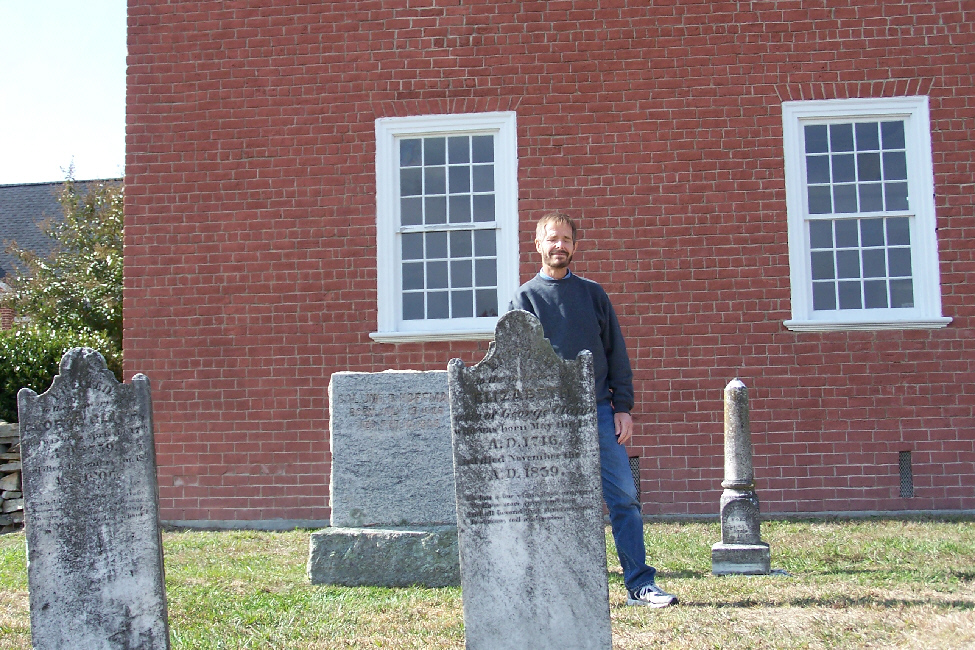
Right beside the church is the church graveyard, and we found it immensely interesting to wander around that graveyard, looking at the gravestones. They dated back to the earliest history of the church itself, and came forward until about the end of the nineteenth century. Prominent among the graves were those of the extended Clapp family, that family figuring into the organization of the church itself. We took a number of pictures of some of the gravestones, and I've put a list of some of them below. To see the actual gravestone, just click on the items in the list:
| George Washington Clapp |
| Johann Ludwig Klap |
| John Clapp |
| John B. Clapp |
| Emily |
| Barbara |
When we were done at the church, right around lunchtime, we left the area and headed over to Judy's.
An Afternoon at Judy's House
 |
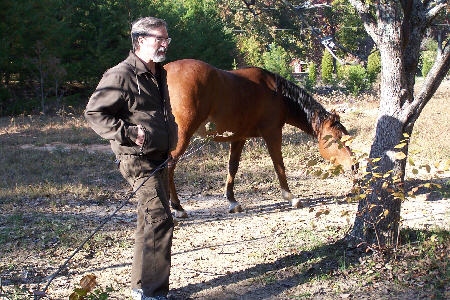
We got to Judy's in the early afternoon and we had a bit of lunch with her and Patrick. Ted had already left for his seminar in Newport News, VA, and he had left his dog, Lucy, with Judy. Judy has a couple of small dogs- daschunds- who are indoor dogs. They are small enough to sit in her lap while she relaxes in her favorite chair. Lucy is much too big for that, but not so big, apparently, that she can't jump up on just about everything and everyone- including the other dogs. They did a lot of running around while we were sitting and conversing; I was once again reminded why it is that when I have a pet, it's a cat.
|
|
 |
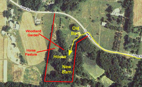
One of the aspects of Judy's farm of which she is justifiably the most proud is the woodland garden that she has constructed in the copse of trees right in front of her house. Some years ago, she got the idea to clean out that area of trees, which had always been just a wild area that served to block the line of sight from the road to the house, giving the house a very secluded feel. When she got it cleaned out, though, she had the idea to try to duplicate the kind of forest trail that she'd hiked locally or in the mountains and, over a couple of years, worked diligently and hard to transform the forest into that kind of environment. Of course she built some trails, and of course she brought into the area many plants from elsewhere on the farm and from outside the farm that would do well in such a shady area. So the paths became more of a nature trail than just a path.
|
|
The garden is really an incredible and very restful place, and in the summer is a riot of plants. Judy and Patrick tell me that they spend lots of time out here when the weather is nice. So do the dogs, apparently, because there are lots of places where they seem to root around. Today, it being quite chilly, the dogs have little sweaters on.
We took a walk over to the new barn so Judy could show Fred her four cats and we walked down the driveway to the old barn so Judy could pick up the mail.
Finally, Judy and Fred spent a good deal of time wandering around the garden and examining the plants that were still producing this late in the fall. Judy and Fred both share this interest in horticulture of all kinds- vegetables, flowers, trees, whatever- and Fred was very intrigued by an evergreen that he had heard of but had not seen before.
We spent a really relaxing afternoon with Judy and Patrick. At dinnertime, we decided to go pick up some Chinese food and brought it back for a little buffet. We watched "Sordid Lives," one of the movies that Fred had brought along with him, and generally just vegetated. Along about ten, we left for the motel a couple of exits east on I-40.
You can return to today's index or use the links below to continue to another photo album page.
|
November 9, 2007: Georgia/North Carolina Trip Day 7 |
|
November 7, 2007: Georgia/North Carolina Trip Day 5 |
|
Return to Main Index for Georgia/North Carolina Trip |
