|
November 26, 2009: Thanksgiving |
|
November 2-21, 2009: Our Panama Canal Cruise |
|
Return to Index for 2009 |
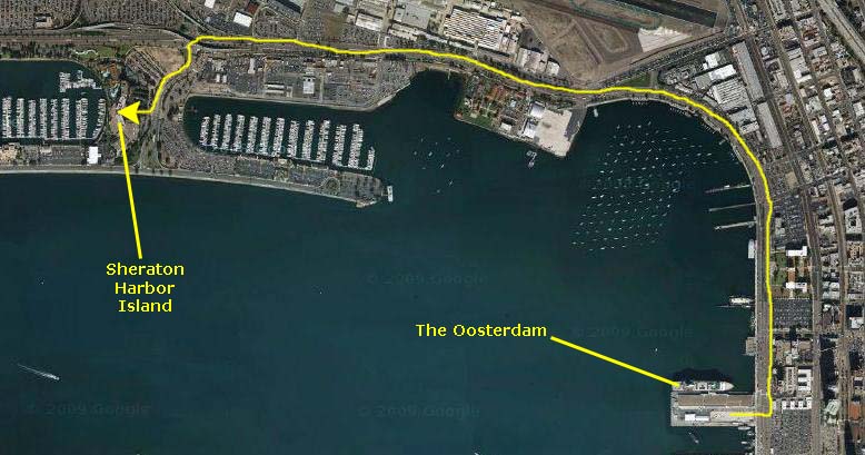
From the Oosterdam to the Sheraton
|
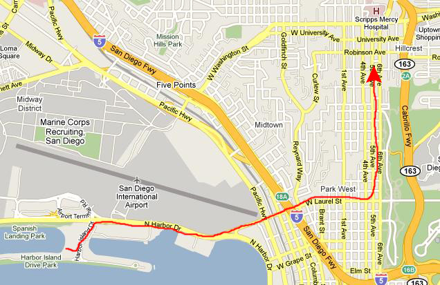
Since I was driving, I'm not responsible for any of the pictures taken on our short ride to the hotel. Actually, there was not much of note save for one of the tall ships that are docked in front of the Maritime Museum at the San Diego harbor. It was a simple matter to follow the road around the harbor north towards the airport and then, just in front of the airport, to turn left onto Harbor Island Drive.
The Harbor Island Sheraton was the hotel where Greg had made our reservations. It's a nice hotel, centrally located for what we wanted to do this weekend. We brought our stuff into the lobby where Greg and I spent a few minutes checking in. Then Fred and I and Greg and Paul went up to our rooms to relax for just a while before heading out to our first activity of the day.
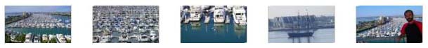
Our room was on the west side of the Sheraton, so our view was north towards the airport and up the coast and west out across the huge marina with thousand boats (my estimate). We could also look a bit southwest out the channel from the harbor to the Pacific before our views were blocked by the other wing of the hotel. There may not actually have been a thousand boats, but there were more than I could count. We took a number of good shots from our balcony looking in different directions, and if you will click on the thumbnail images below you can have a look at some of them:
|
|
I made this movie looking west from our balcony at the Sheraton, panning across the multitude of boats and looking out the channel from the harbor to the Pacific. |
The San Diego Zoo
Getting to the Zoo
|
In any event, we got to the zoo with no problem and parked in the huge lot with a zillion other cars. Then we walked to the end of the lot, past the elephant topiary (one of the largest sculpted plants I've ever seen), and over to Zoo entrance. We paid our entrance fees and headed on in.
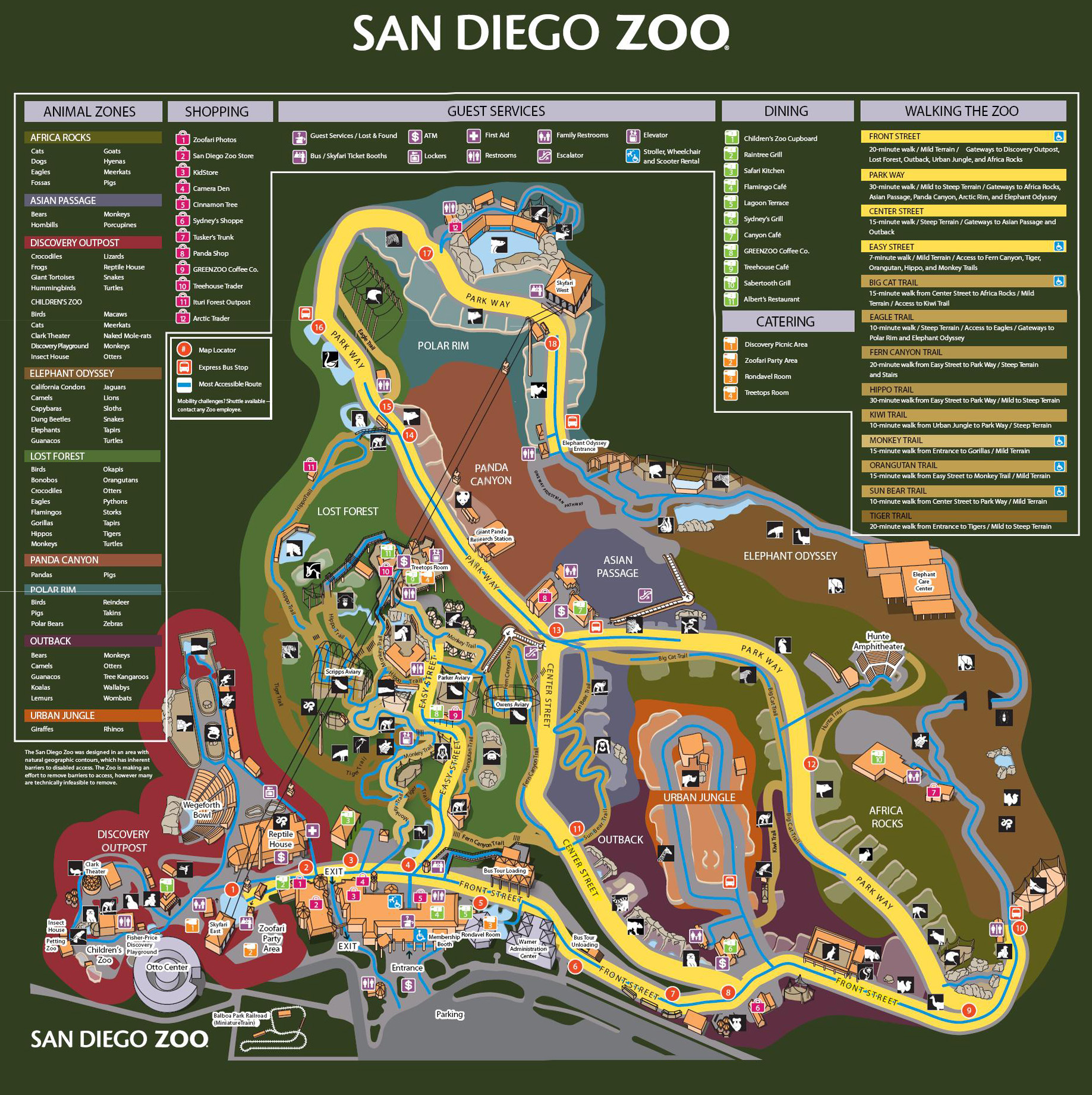
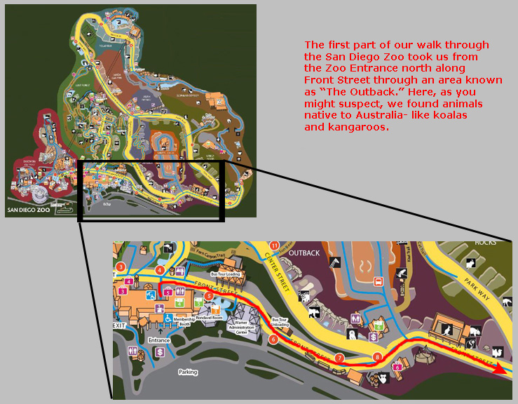
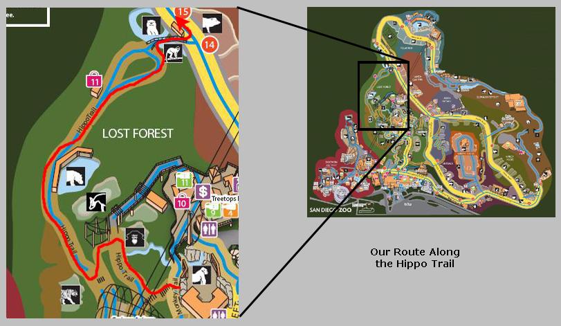
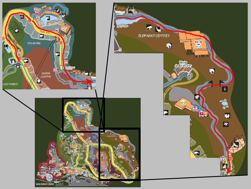
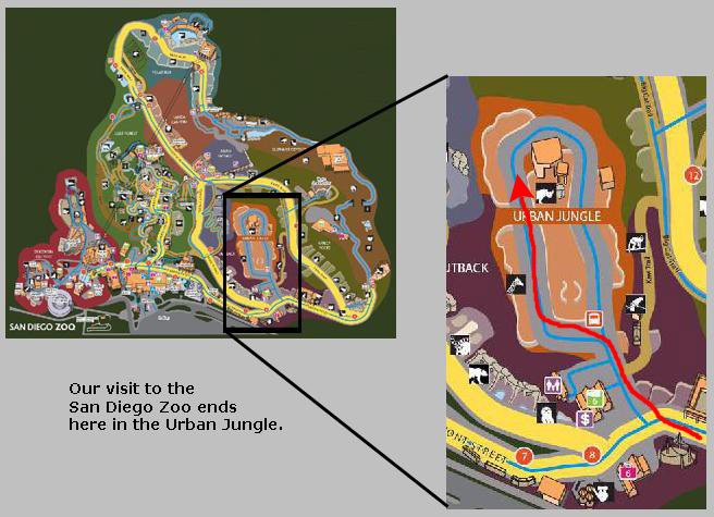
There is no one path that you can take through this very large Zoo that will get you to see everything without retracing your steps at least somewhat. I am going to do my best, though, to show you the path that we took through the Zoo and the pictures that we took along that path. To aid you in following along, I have created a large Zoo map- large enough for you to read the names of all the exhibit areas and many of the animals as well. On this map, I will mark our route in segments of different colors, and we will take our trip through the Zoo one segment at a time. I have put this very large map in a scrollable window below, and you can use it to follow along as we tour the Zoo.
|
(One thing that you will want to remember about this map is that, unlike almost every other map and aerial view I've used in this album, the orientation of this map is that north is to the right, instead of to the top. I'll be using directional descriptions fairly often, so it's important that you keep the map orientation straight in your mind.)
Segment 1: The Outback
|
Also, just inside the Zoo, we walked by the two stations for loading and unloading the park's tour buses. We gave some initial thought to just using one of them for our tour through the Zoo, but quickly discarded that notion so that we could go where we wanted to and stop where we wanted, and also so we could get some exercise. If we had a couple of days here, we might first have ridden the bus around just to see how the Zoo was laid out and get the spiel from the tour driver, but since we only had an afternoon, we didn't.
What we did do was stop in front of the first directional sign to try to decide which way to go. There seemed to be no one good way to circle through the park and see everything, so we just headed to the right (north) to the Outback area.
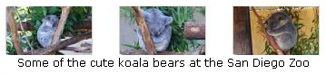
One of the first stops we made was at the koala enclosure. The koalas are those cute little animals that you used to see in the Quantas commercials. With my little camera, all I could get was the enclosure, but with his excellent zoom, he was able to get closeups of the animals themselves. If you'd like to see some of these cute koalas, just click on the thumbnail images below:
|
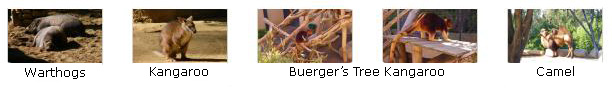
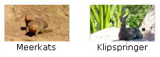
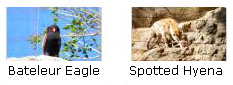
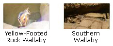
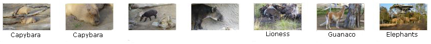
If you will click on the thumbnail images below, you can see some of the other animals (some quite familiar) that we saw here in the Outback section of the zoo:
|
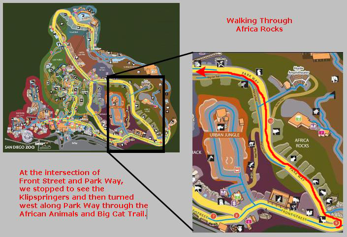
Segment 2: Africa Rocks & Big Cat Trail
|
|
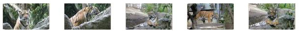
When we got halfway along Park Way, we came to another main signpost and made the decision to head up the hill to follow the Big Cat Trail. Along the trail, we saw the Spotted Snow Leopard, the African Tiger and the Jaguar.
|
We couldn't get very close to the Jaguar, but I was able to make a movie of the jaguar pacing back and forth. |
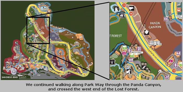
Segment 3: Panda Canyon & Lost Forest
|
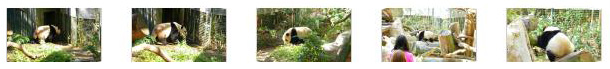
There were two pandas that we could see here at the zoo. The first was Su Lin, who is about five years old and weighs 215 pounds. She was born here in the zoo, is now an adult female and is completely solitary. The other panda we saw is Zhen Zhen, who is two years old and weighs 115 pounds. Zhen Zhen sleeps about 12 hours a day and eats about ten pounds of food a day. She too, like all pandas, is also naturally solitary. Her new cub, Yun Zi (Son of Cloud) is still in the back of the enclosure with her mother, Bai Yun (White Cloud), and will not come out for viewing until sometime in December whenb his mom is ready to bring him out. Bai Yun is also mother to the other two pandas, Su Lin and Zhen Zhen. Below are some thumbnail images for pictures of Su Lin and Zhen Zhen; click on them to view the full-size images:
|
|
I filmed a movie of the panda named Zhen Zhen wandering around her enclosure. |
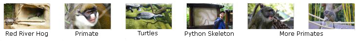
As we continued along Park Way heading west, we crossed part of the Lost Forest area of the zoo, where we encountered the Allen's Swamp Monkey and the African Spot‑Necked Otter, among other animals. There were also flamingos and birds of various kinds sharing some of the habitats. Click on the thumbnail images below to see some of the animals we saw as we crossed through the Lost Forest:

|
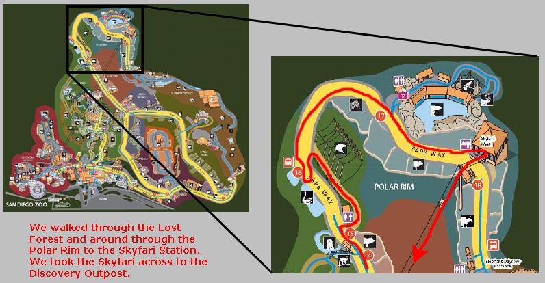
Segment 4: Polar Rim
|
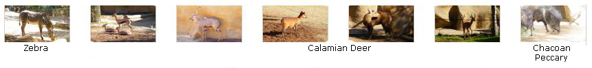
I assumed that the Polar Rim would house animals from the far north, but there were animals from Africa (the zebra) and from South America (the Chacoan Peccary). There was also a relative of the reindeer- the Calamian Deer- from the Philippines. (Along the way there was an interesting polar bear sculpture, and I was able to get Fred's picture with it. Below are some thumbnail images for most of the animals we saw; click on them to view the full-size pictures:
|
Segment 5: A Ride on the Skyfari
|
I made a movie as the four of us were riding along above the trees on the Skyfari. |
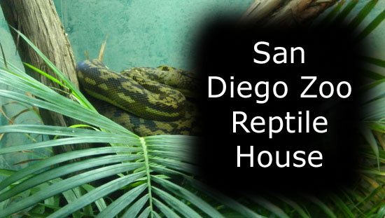
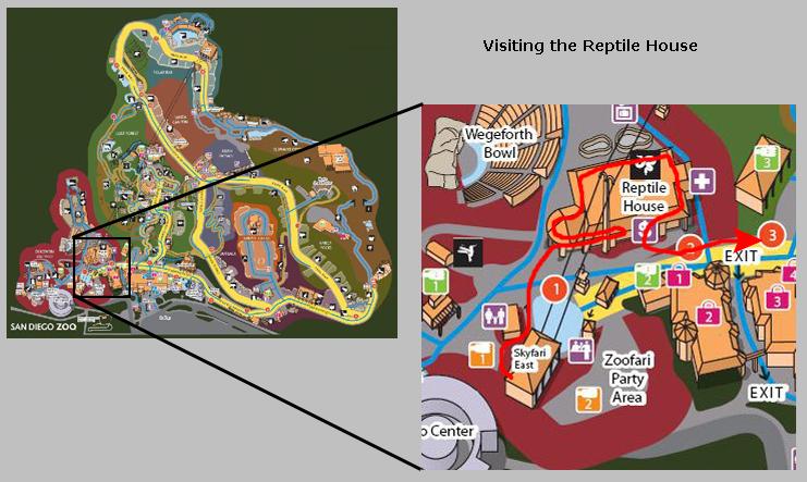
Segment 5: Visiting the Reptile House
|
The reptile house was well-designed to minimize crowding when looking at all the snakes and lizards in their glass-enclosed terrariums. One round section of the house was totally enclosed; here, the zoo housed its Komodo Dragon.
|
To view the slideshow, just click on the image at left and I will open the slideshow in a new window. In the slideshow, you can use the little arrows in the lower corners of each image to move from one to the next, and the index numbers in the upper left of each image will tell you where you are in the series. When you are finished looking at the pictures, just close the popup window.
Segment 6: The Monkey Trail & Scripps Aviary
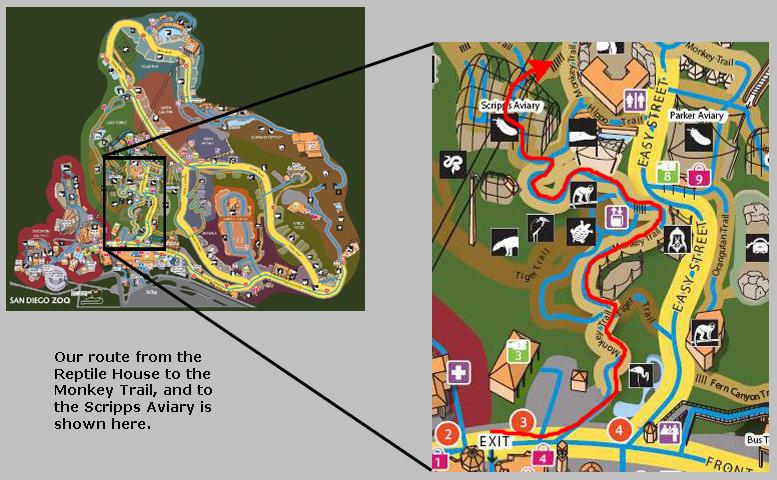
|
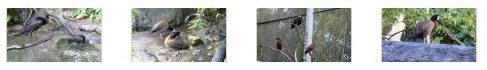
Right at the beginning of the Monkey Trail there was a small pond filled with Flamingos; they are a familiar, but always beautiful and interesting sight. For the next half-hour or so we wandered along the Monkey Trail, stopping at all the enclosures to take pictures and look at the wide variety of primates and other animals along our path. We saw one primate that I don't ever remember seeing before- the Kikuyu Colobus. There were lots of other monkeys in enclosures along the trail, and you can see a few good pictures of some of them here and here and here.
|
|
I made a movie inside the aviary to show you the waterfall, how the walkways were arranged, and the guys. |
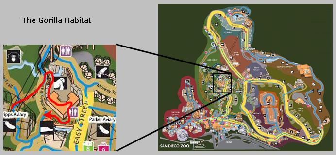
Segment 7: The Gorilla Habitat
|
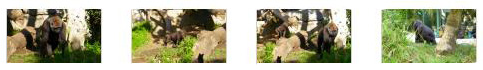
Going through the gorilla habitat was very interesting. The walkway takes you along a rock-bordered path that is separated from the habitat by a moat and other obstacles to keep visitor and gorilla apart. Along this path, you can get some good views of the gorillas if they are out and about. Then the trail takes you into a viewing area, which is basically a three-sided building with a wall of glass looking out onto the habitat. When we were in the viewing area, which is L-shaped to provide good viewing angles out into the habitat, there were three gorillas that came up and sat down right next to the glass, giving us up-close-and-personal views. At the exit from the viewing area there were some interesting sculptures, and so Fred took a picture of me with one of them and I took a picture of Fred with the others.
If you'd like to see some more pictures of the gorillas in their habitat, just click on the thumbnail images below:
|
Segment 8: The Lost Forest
|
When we turned onto the Hippo Trail, we passed two or three primate habitats. One of them contained a number of coal black monkeys that were either sitting singly or were in what looked like for all the world as romantic pairs. There was also a habitat that contained, by my count, three orangutans that you could see through large plate glass windows. If you would like to see some additional pictures of the monkeys and orangutans, just click on the thumbnail images below:

|
|
Fred made a good movie of some of the primates in one of the enclosures along the Hippo Trail. |
Of course, there were hippos along the Hippo Trail. There was a viewing building where you could get a look at them in or under the water. You can see a couple of the pictures that I took here and here. Outside the viewing building there was also an interesting hippo sculpture.
|
|
Segment 9: Elephant Odyssey (and a second visit to Polar Rim)
|
When we went beyond the Skyfari Station in Polar Rim, we passed some animal enclosures that we had missed the first time we came through. We saw some young reindeer as well as an unknown animal that looked like a gazelle (I should carry a pad to write down stuff when I take pictures). There was also an enclosure containing a number of Sichuan takins, an animal that inhabits the northern part of central China. You can have a look at a good closeup of this animal here.
|
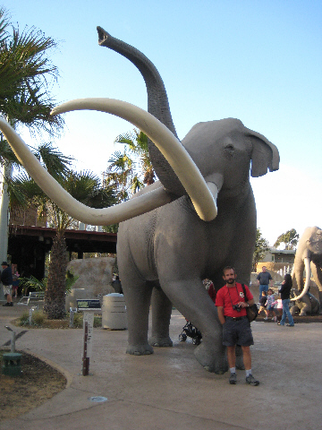
This was an area that kids could enjoy, too. There was a recreation of a fossil dig that showed, through a series of exhibits, how paleontologists have pieced together the history of so many animal species. And of course there were a number of large mammoth sculptures that seemed to be a big it with the kids.
Among the other items was a sculpture of a giant ground sloth, and you can see a picture of Fred with it here.
Our walk through the Elephant Odyssey was very pleasant in the late afternoon sunlight. There was a lot to see. Fred, Paul and I were taking lots of pictures, so I've selected the best of them to include here. Where one of us captured a sign with the animal's name, I've labeled the images appropriately. Click on the thumbnails below to see the best of the pictures that we took:
|
|
Segment 10: The Urban Jungle
|
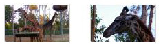
|
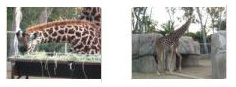
|
|
I made a movie while the giraffes were eating, and then two of them obliged me by walking into another part of the enclosure. |
This brought our visit to the San Diego Zoo to an end. We left the Zoo just before closing, got back in the car and headed off to the Sheraton. Once there, we all relaxed for a while and then met up for dinner at a seafood restaurant further down the island that had been recommended by the concierge. It turned out to be way overpriced and barely average. After all the great meals on board ship, our first meal off of it was pretty bad.
It was an early night; tomorrow we'll be touring around the San Diego area from La Jolla to Point Cabrillo.
Breakfast at The Hash House a Go Go
|
The menu was pretty extensive, but the place is known for its "skillets." These are meals served in a large iron skillet, and they usually consist of some of the famous corned beef hash (or other types, such as regular beef and chicken, along with more esoteric varieties), eggs, potatoes, a huge biscuit and some fruit. We could see the meals being served at the other tables; everything was in gargantuan portions. Greg ordered one of the skillets; even he thought it was a lot of food when it came, and Fred got a picture of him ready to dig in.
Fred got a smaller breakfast that consisted of a hash/egg omelet, a biscuit, potatoes and melon. Against my advice, Fred also ordered a single pancake. The had lots of different kinds; the one Fred ordered was a mango pancake and it was actually quite good. He asked me to make a start on it, and when I did he snapped a picture. You can see it here. Paul also had a pancake- blueberry, I think- and a bowl of fruit (which also could have been a breakfast in itself).
It was easy to see why this place was so popular. The crowd was young and hip, drawn from the local area near San Diego State University. The decor and menu were both eclectic, and the food was very good. I think we all got enough to last us through the day.
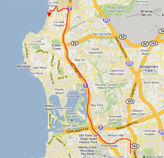
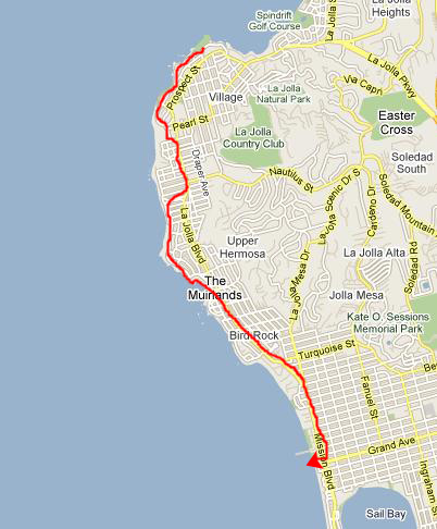
A Drive Down the Pacific Coast
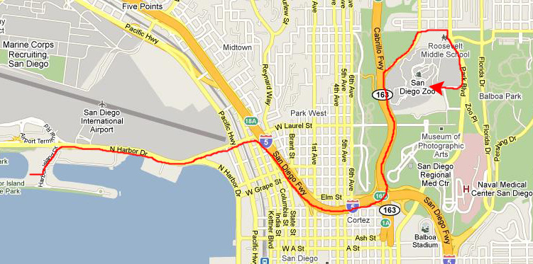
Getting to La Jolla Shores
|
I got us from the Hash House to Interstate 5, and we took that north almost to Torrey Pines, where we got off the freeway just south of the University of California at San Diego.
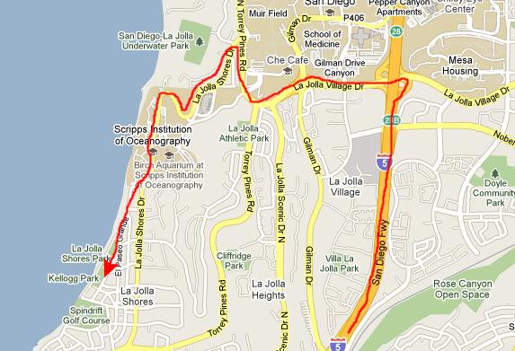
|
We turned west on La Jolla Shores Drive and went downhill towards the Pacific, coming out at the coast just north of the Scripps Institute of Oceanography. At first I thought we might stop at the Institute, but on thinking about it I realized that a stop there could easily chew up the entire day- something like the zoo. So we all decided to just play it by ear as we drove south along the coast, following our noses and stopping wherever it looked interesting.
So we drove through the area around the Institute and continued southward. It turned out that our first stop was at Kellogg Park- right on the Pacific Ocean.
Kellogg Park at La Jolla Shores
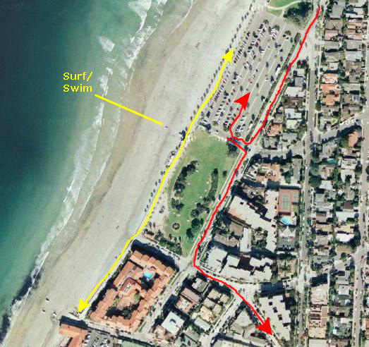
|
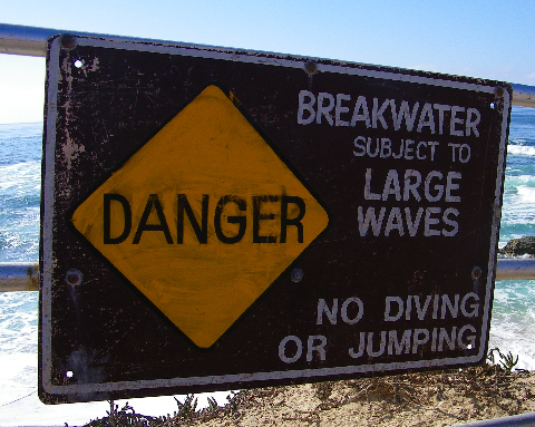
It did seem that this was a busy local surfing site, and there were certainly a lot of them around- all of them in their wet suits (as the water temperature was quite chilly). There was a sign dividing the beach into separate areas for surfers (on the north) and swimmers (on the south), undoubtedly to reduce the possibility of some non-surfer getting hit by a board.
It was a beautiful day, and there was a plethora of "surfer dudes" trying their hand at the waves. Just north of Kellogg Park we could see the Scripps Institute pier- with its "No Diving" admonition. As it turned out, there WERE some SCUBA divers at the south end of the park and our walk (in the picture using the outdoor showers to rinse off themselves and their equipment). There were a couple of lifeguard stations along the beach- just like in "Baywatch." It was at one of them that we discovered just how chilly the water was.
|
To view the slideshow, just click on the image at right and I will open the slideshow in a new window. In the slideshow, you can use the little arrows in the lower corners of each image to move from one to the next, and the index numbers in the upper left of each image will tell you where you are in the series. When you are finished looking at the pictures, just close the popup window.
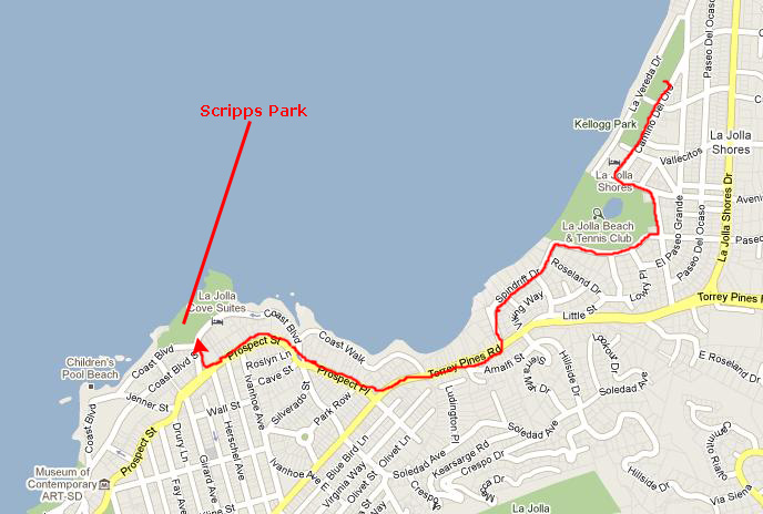
La Jolla's Scripps Park
|
We just left Kellogg Park and drove through residential streets heading south. As I drove, Fred was able to get some good views of the hillside houses here in La Jolla. As I recall, Peter's parents lived just at the crest of one of these hills, but I have no idea now where. We had to detour around the La Jolla Country Club, but, where we could, I hugged the shoreline. When I wasn't sure where a street would come out, we went out to the main street, which here was Torrey Pines Road.
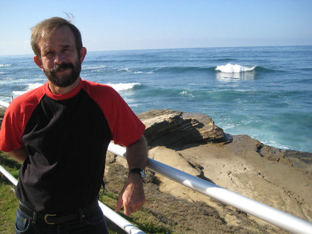
Some of the homes we passed were really spectacular, and one of my favorites of all the pictures Fred took was a home with huge multi‑level balconies; I can just imagine the views they had. Following Greg's idea of where Bud and Chet had lived, we headed back over to the coast, passing a very pretty church done in very much a Mission California style. At the coast, we drove down towards the Pacific and parked the car right across from Scripps Park- right where the folks are loading their car to leave in the picture Fred took that you can see here.
|
We continued walking south along the walkway on top of the cliffs, passing in front of some new construction (apartments or condos) and eventually came to what turned out to be an abandoned lifeguard station and a jetty that curved out into the Pacific. Here, we found a group of seals, took pictures of them and walked out on the jetty.
When we were done there, we all walked back to the car and then continued our trip south along the coast (first driving down to the end of the street we'd parked on to look back towards the Scripps Institute pier.
Let's do this outing a bit more slowly, now, so that I can show you some of the pictures we took and movies we made.
|
We just walked slowly southward along the walkway, admiring the views. I stopped to take a picture of Fred on the walkway, and he took a whole bunch of excellent pictures. It's hard to narrow them down, but if you will click on the thumbnail images below, you can see a couple of these pictures:
|
|
As we began to walk across the park to the Pacific Ocean, I made a movie panning 360 degrees around so you can see the park and this part of La Jolla. |
When we reached the south end of Scripps Park on the walkway, both Fred and I took movies of the Pacific and the park and the walkway, with me in his movie and he in mine.
|
Here is Fred's movie panning across the rocky Pacific shoreline here at La Jolla. |
This is my movie of the waves breaking on the rocky shoreline here at La Jolla. |
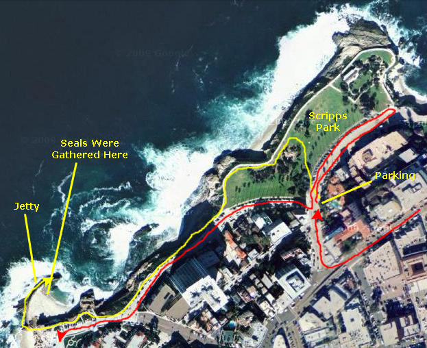
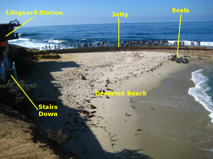
The walkway had been curving inland to match the coastline and when we got to the end of the park there was a ramp down to an observation station, and then, beyond that, a stairway down to a rocky beach. You can see both of these features here. The small beach ended in some rocks further south, and we could look ahead and see the jetty sticking out into the water. Meanwhile, the walkway rose back to the street and then continued south about twenty feet higher right alongside the street.
The walkway continued alongside the street until we came to the rocky point from which the jetty stuck out into the ocean. From this vantage point at the south end of the walkway, I could look back along the street and down at the beautiful rocky coast. When I did look down, I saw a large rock that had become separated from the mainland, with just a finger of water between it and the shore. At the top, it was too wide for anyone to jump to it, and so it was isolated. A number of sea birds had figured out they were safe on it; you can see some of them here.
Fred took a number of other excellent pictures while we were walking along the part of the walkway that was higher and beside the street, and if you'll click on the thumbnail images below, you can have a look at some of them:

|
|
I made a movie of the Pacific Ocean waves crashing against a sheer rock wall along the shore here in La Jolla. |
|
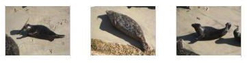
The beach itself appeared deserted; when we got there, there was only one person sitting down on the sand. But there were lots of people out on the jetty, and there were many more up on the sidewalk at the top of the stairs. The most interesting thing was the group of seals that were lying on the sand over near the jetty end of the beach. It appeared that there were twenty-five or so of them.
At first, I thought that perhaps the lifeguard station had been closed because of financial cutbacks, but then the other stations we'd seen today were certainly being manned. We also thought that there might have been some structural problem with the station, but there was still a small beach office on the sidewalk level, and there did not appear to be any damage at all to the structure. It took a while to figure it out. The explanation can be found in the picture you can see when you click here.
|
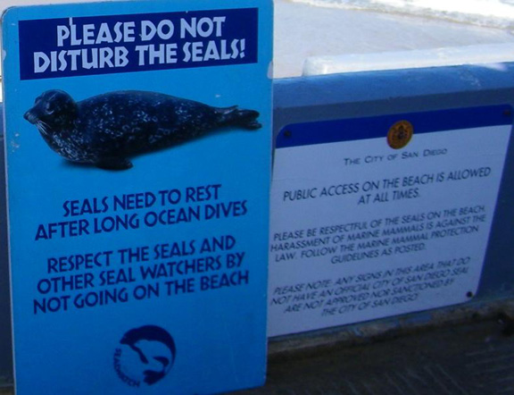
Right next to this sign is what first appeared to be another official sign, admonishing people not to disturb the seals and also not to go on the beach. On reading that sign, it was apparent why almost no one was on the beach. But what about the other sign? Didn't it mean what it said? Wasn't the public actually allowed on the beach, even when seals were present? To answer that question, you have to read the rest of the white sign. The rest of it noted that any other signs are not approved by the city and have no force of ordinance, referring specifically to signs like the blue one.
Now we understood. While the seals are protected with "standard" California guidelines and general ordinances, some folks must have thought that more should be done (can you spell "animal rights activist"?) and so put up their own sign to try to keep people off the beach anyway. (It was only then we noticed a bit further down the sidewalk there was a table set up and a couple of older people handing out flyers and stuff about the seals and about their conservation group.) Either enough people thought that the blue sign was an official one and so stayed off the beach, or didn't want to be thought of as insensitive to the seals, that almost no one went down the stairs. As I said, when we got there, there was only one person on the beach.
In any event, Fred and I took quite a few pictures from our vantage point up on the sidewalk, and if you click on the thumbnails below you can have a look at some of them:

|
|
|
While we were reading the signs and looking at the beach, we saw a couple of snorkelers swim into the beach from the ocean, get out of the water and start laying out their gear. They were joined by a friend who came down the stairs and the three of them were on the beach for quite a while. All this is to say that I now felt entirely comfortable with going down the stairs and getting to the beach where I could get some pictures. (I did that shortly, and noticed that, soon after, a number of other people did the same thing. So much for the herd mentality. One guy even came down later, set up a beach umbrella and chair and took up residence. You ought to see what he had written on the top of his umbrella by clicking here.)
Fred followed me down onto the beach after a few minutes, and both he and I took some good pictures from down at the ocean's edge- including pictures of the seals and jetty, birds on some of the offshore rock pillars and a small natural bridge. Click on the thumbnail images below to have a look at them:

|
It certainly looked as if the best place from which to view the seals was from out on the jetty, so we went back up the stairs and walked over to the point where it began. It was pretty crowded; the jetty was barely two people wide, and people were coming and going off of it.
|
Right at the beginning of the jetty, before we began to walk out on it, I made a movie of what it and the surrounding shoreline looked like. |
|
We got out to the end of the jetty and back, but the best viewing was right above the seals. While I was taking some closeup pictures of a few of the individual animals, Fred snapped a picture of me and others watching the seals. Click on the three thumbnail images below to see some of my closeup pictures:
|
We stayed out on the jetty for quite some time, just amazed at being so close to these animals in someplace other than a zoo. They seemed almost comical, sometimes, as they tried to move around on the beach. It seemed that a few of them were able to use their front flippers to help themselves, but most of them just undulated their bodies and kind of jumped forward or rolled sideways. They were very interesting to watch. Click on the thumbnail images below to see some more pictures of the seals- some taken from the jetty and some taken from the walkway:

|
|
Amidst my still pictures, I made a movie of the seals flopping around on the sand beach. |
We had been on the jetty about twenty minutes when the seals got it in their minds to head back into the ocean, and Fred made a movie of them leaving the beach. |
When we were done out on the jetty, Fred and I walked back to join Greg and Paul, who'd been sitting up on the walkway watching us watch the seals. On the way, as we stepped off the jetty back onto the mainland, Fred took a picture looking south along the coast. Just before the four of us turned to walk back to the car, Fred took a group picture. When we got back to the car, we drove a bit further north down to the end of the street by the park to look at the views back north towards La Jolla Shores and the Scripps Institute. Then we turned the car around and continued south along the California coast, following the shoreline as closely as we could.
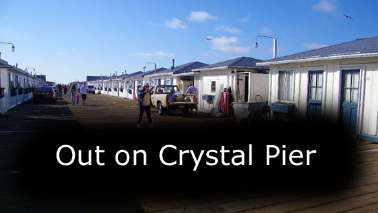
Pacific Beach Park and Crystal Pier
|
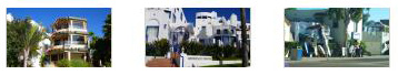
We took this main street south along the coast. There was a fair amount of interesting stuff to look at- interesting buildings (such as the La Jolla Contemporary Art Museum), eclectic restaurants (no one seemed hungry for lunch) and a wide variety of shops- in what appeared to be a very trendy area. It was a typical California beach community. Click on the thumbnails below to see some of the other interesting sights we passed:
|
A few miles south, we saw some signs for Pacific Beach Park and something called The Crystal Pier, so we thought we might as well stop and walk around. Parking was a trick, so I let the guys out in a little cul-de-sac at the south end of the park, and circled around until a parking space opened up right near where they got out. Then I, too, headed the few feet over to the beach and the very pretty promenade walkway along it.
I couldn't see where the guys had gone, and so I was walking along by myself, figuring that the guys would eventually return to where I'd let them off. I was never out of sight of that spot, and eventually they turned up. But we weren't together while we were taking pictures. I'll group together the things both Fred and I photographed, but each of us saw some things that the other didn't.
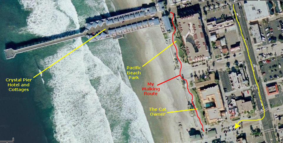
My walk took me from the beach access at the small parking lot in the cul-de-sac north along the park to the entrance to the Crystal Pier Hotel and Cottages and then back again. The walkway was very wide, reminiscent of the movies you see of Venice Beach in Los Angeles, and all the skaters and other folks walking up and down. The difference here was that the walkway was not nearly so crowded; in fact, I thought it was very lightly-used for a beautiful Sunday afternoon. There were lots of shops and restaurants down by the parking area and up by Crystal Pier, but mostly there were condominium or apartment complexes bordering the park and walkway. Perhaps that's why there wasn't so much traffic. All I can say is that I think if I lived nearby, I'd be over here every day when the weather was nice (which is most of the time in Southern California). I've put an aerial view of the area where I walked below, and marked some of the things you'll see in the pictures:
|
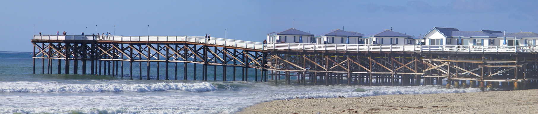
I suppose that the most prominent sight here at Pacific Beach Park was the Crystal Pier Hotel. I had never seen anything quite like it. It was even more impressive when I got close to it. While I walked up to its entrance and just looked in, I found out later that Fred and Greg had gone out onto the pier itself (which is, apparently, quite allowable even if you aren't staying there).
|
There are about twenty-five cottages that are built on top of the Crystal Pier, which was itself renovated and partially rebuilt about thirty years ago. So the draw is that you are sleeping literally over the ocean. Guests can drive their cars out onto the pier and park beside their cottages, each of which has a balcony/patio facing either north or south from the pier. Some of the rooms at the hotel are not actually on the pier, but in the two buildings flanking its entrance.
The cottages are like Elinor Village in Florida that we used to go to- furnished and with basic stuff, but you have to bring your own beach towels. For all that, the rates seem pretty steep (if what some of the hotel sites indicate)- something like $300/night in season. (Again, the web site for the hotel itself was singularly uninformative; one apparently has to call the hotel to find out what the rates are.)
|
To view the slideshow, just click on the image at right and I will open the slideshow in a new window. In the slideshow, you can use the little arrows in the lower corners of each image to move from one to the next, and the index numbers in the upper left of each image will tell you where you are in the series. When you are finished looking at the pictures, just close the popup window.
I think that Fred and Greg might actually have been out on the pier while I was at its entrance; some clues in some of the similar pictures we took seem to indicate that. But I walked back down the broad sidewalk towards the car. When I got there, I made a movie.
|
|
While I'd been standing around, and before and after I made the movie above, I'd been hearing a sound that was very familiar to me- that of a small cat or kitten meowing. I looked around and didn't see anything; I even looked up in the palm trees to see if an animal had gotten stuck. It took me a minute of wandering around before I realized that the sound was coming from the man sleeping on the grass. And when I walked over to him I could see the source of the sound. It was an adorable little kitten that seemed to be nestled up against the man's body. (I thought at first that here was a homeless person, but then the backpack and the open book made me think it was just a local who'd come to the park and who'd fallen asleep reading.) I still didn't connect the cat to the man until the cat got up and came over to me. Then I could see it was on a leash that was tied to the man's arm. I don't know of any homeless people who take pets around on a leash. At first, I was the only person intrigued by the cat, but pretty soon a young woman also stopped to look at it. Here is a better picture of the kitten.
Just after I made the movie that you can watch below, I prevailed upon the young woman to take my own picture with the kitten, and you can see the result here. (Oddly enough, through all of this the man never stirred, and he was still lying in the same position when Paul and the other guys showed up and we headed back to the car.)
|
I couldn't resist making a movie of the little kitten as it investigated the woman and climbed all over me, and the movie turned out well. You should definitely have a look. |
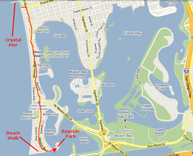
Bayside Park
|
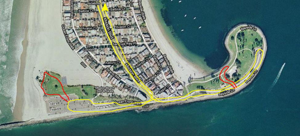
When we got to the park, we first pulled into the parking area for the park itself, left Paul and Greg in the car, and got out to walk around. The first picture I took was Fred beside the Mission Bay inlet, perched on the rock retaining wall at the south side of the park. (You can refer to the aerial view below where I've marked our car route and walking routes.)
Then we walked across the narrow park to the bay side of it. Here, we found pleasure boats at anchor in Mariner's Basin. It brought back fond memories of sailing on Lake Ray Hubbard when we saw a thirty‑footer headed out for a sail. It would be nice to live here and keep a sailboat across the street from your house and be able to go out at a moment's notice. We saw one sailor who'd brought his catamaran onto the beach, and from the line of similar boats up next to the houses lining the street we'd come down, it would seem that he was going to pull it out of the water and just leave it on the beach. Have a look at that picture here.
We took similar pictures of each other here at Bayside Park. Here is the one I took of Fred; you can look at his picture of me here.
|
I made a movie while we were here in the park, panning around 360 degrees. |
As I mentioned above, I thought you might be interested in seeing both Bayside Park and the beach area where we walked from the air, so there is an aerial view below. I've marked the route we took driving and the two short walking routes as well.
|
We drove over to the beach side of the end of this peninsula, and again Fred and I got out to walk around. There was a small grassy area here with picnic tables and a large parking area- presumably for beach daytrippers or surfers. There was some sort of lifeguard facility or park facility here, and from up on the sandy berm between the park area and the beach itself, I had a good view looking south. Fred was also taking some pictures, and if you will click on the thumbnail images below, you can have a look at some of them:
|
A Stop at Ocean Beach Park
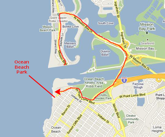
|
There wasn't much there but beach. We could see a surfer or two north of us, and quite a few of them south of us. There was, apparently, some sort of competition going on, even though the waves weren't very high. Once again, Fred and I traded pictures; you can see my picture of him here and his picture of me here.
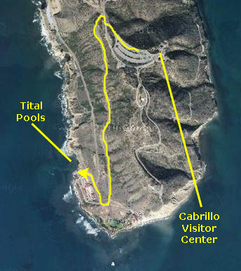
We walked back to the car that we'd had to park on a side street, took a look at the map, and headed off for our last stop of the day at the southernmost point on the coast north of San Diego (before you reach the main broad inlet into San Diego Bay- Cabrillo Point.
Cabrillo National Monument at Cabrillo Point
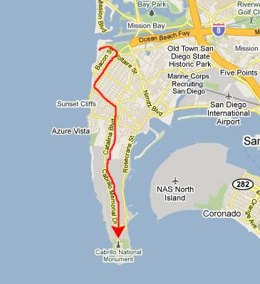
|
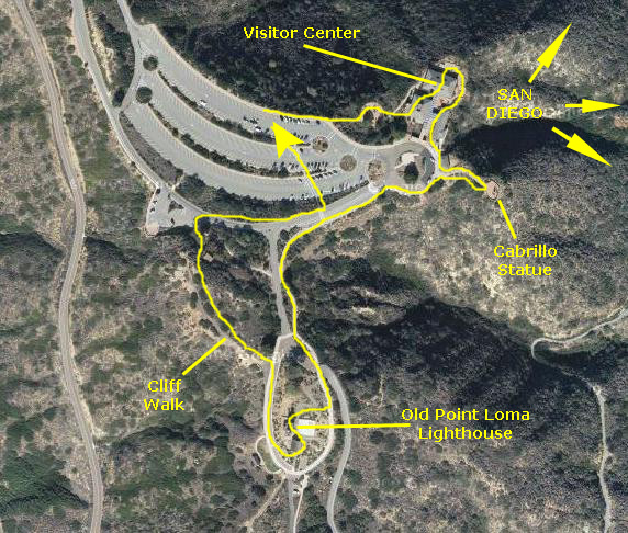
The road climbed up to the crest of the peninsula and soon we could see the Visitor Center complex up ahead. We followed the signs to the parking area and then piled out of the car to spend 90 minutes or so here before the park closed. We'd been looking at the brochure we got at the entrance station and we'd planned a few things to do- take some pictures of the San Diego area from our perch 500 feet up, find the Cabrillo statue and visit the Old Lighthouse and Museum. So we walked over to the Visitor Center to get started.
Cabrillo National Monument is located at the southern tip of the Point Loma Peninsula, and it commemorates the landing of Juan Rodr�guez Cabrillo at San Diego Bay on September 28, 1542. This event marked the first time that a European expedition had set foot on what later became the west coast of the United States. The annual Cabrillo Festival Open House is held each October on Sunday. It commemorates Cabrillo with a reenactment of his landing at Ballast Point, in San Diego Bay.
|
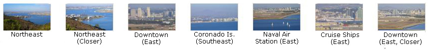
We also want to include here pictures that we took of San Diego and the surrounding area from our vantage point up here on the peninsula. We took these pictures throughout our walk around the area.
Because we took so many pictures, it makes sense to organize them by subject, and organize the subjects in the order in which we visited them. We'll group all the scenic pictures together into a group, and deal with those first.
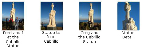
Before we do that, though, I want to show you some pictures that we took from the viewing terrace at the Visitor Center. From here, we could look southeast towards the Cabrillo statue, which will be the next place we visit. (Fred got another picture of the statue from here using his zoom lens, and you can have a look at that picture here.) Looking down below, Fred got a great picture of a vintage schooner coming in to the harbor. Finally, I prevailed on Paul to take a picture of Fred and I on the viewing terrace.
We took pictures of San Diego and the surrounding areas- north, east and south- from all over the Cabrillo National Monument. Many of them were taken from the viewing terrace, although good views were also available from the Cabrillo statue and from the lighthouse. If you will click on the thumbnail images below, you can see the best of these pictures:
|
|
|
|
I made a movie from the top of Cabrillo NM panning across the San Diego area from northeast to south. |
From the Visitor Center Observation patio, where most of the pictures of the San Diego area were taken, we walked around to the south and then followed the short walkway out to the Cabrillo statue.
|
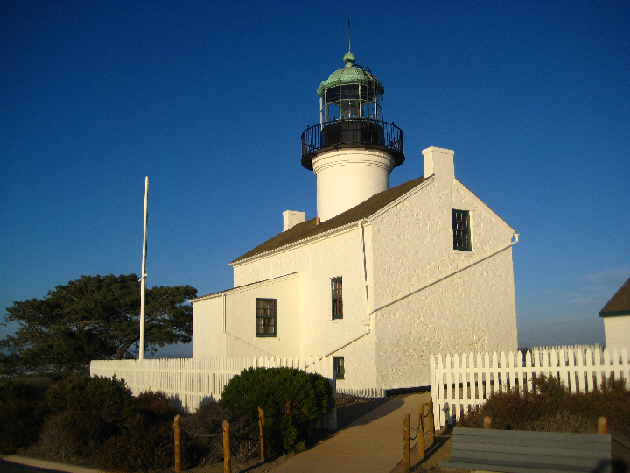
At the highest point of the park stands the Old Point Loma Lighthouse, which has been a San Diego icon since 1854. Old Point Loma Lighthouse stood watch over the entrance to San Diego Bay for 36 years. In 1851, a year after California entered the Union, the U.S. Coastal Survey selected the heights of Point Loma for the location of a navigational aid. The crest seemed like the right location: it stood 422 feet above sea level, overlooking the bay and the ocean, and a lighthouse there could serve as both a harbor light and a coastal beacon.
|
At dusk on November 15, 1855, the keeper climbed the winding stairs and lit the oil lamp for the first time. Thus began the early years of the Point Loma Lighthouse. In clear weather its light was visible at sea for 25 miles. For the next 36 years, except on foggy nights, it welcomed sailors to San Diego harbor.
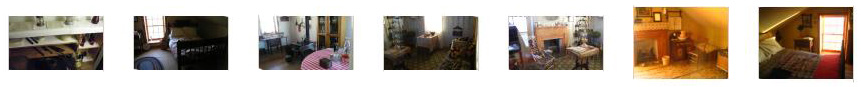
As with other lighthouses we've visited- on the Oregon Coast, in Maine and in Wisconsin- the family of the lighthouse keeper usually lived at the lighthouse. It was impractical for them to live anywhere else, since by their very nature lighthouses were usually at locations far removed from population centers. When we went into the Old Point Loma Lighthouse, we found that the National Park Service had refurbished the interior to its historic 1880s appearance - a reminder of a bygone era.
If you will click on the thumbnails below, you can see some pictures that we took of the living quarters here at the Old Point Loma Lighthouse:
|
But what seemed to be a good location 422 feet above sea level had a serious flaw. Fog and low clouds often obscured the light. On March 23, 1891, the light was extinguished and the keeper moved to a new lighthouse location closer to the water at the tip of the Point. Today, the Old Point Loma Lighthouse still stands watch over San Diego, sentinel to a vanished past. Ranger-led talks, displays, and brochures are available to explain the lighthouse�s interesting past. The Old Point Loma Lighthouse is a reminder of simpler times - of sailing ships and oil lamps and the men and women whom day after day faithfully tended the coastal lights that guided mariners.
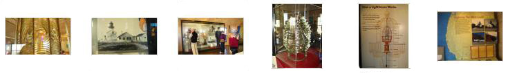
Right next to the lighthouse there was a museum with some very interesting exhibits, and we spent a fair amount of time there. Some of the pictures we took inside turned out well, and if you click on the thumbnails below you can have a look at them:
|
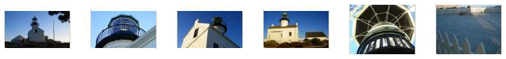
Before we leave the Old Point Loma Lighthouse, I'd like to include a few more pictures here- different views of the lighthouse. The last (rightmost) picture is the catchment that provided fresh water to the occupants of the lighthouse. It was a broad, flat, watertight area that sloped down to a cistern system. It caught rainwater. Click on the thumbnail images below to have a look at these pictures:
|
The area encompassed by the national monument includes various former military installations, such as coastal artillery batteries, built to protect the harbor of San Diego from enemy warships. We could see many of these installations as we walked around the area. A former army building hosts an exhibit that tells the story of military history at Point Loma.
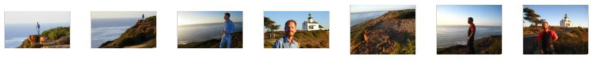
After we finished at the lighthouse, Fred and I walked down the road that leads back to the Visitor Center. Off to the west, there is a path that you can take that leads out onto a cliff shelf that overlooks the Pacific Ocean. The cliffs aren't really high, and there is sloped land beneath them that leads down to the water, so if you happen to fall, you might break and arm or leg if you land wrong, but you won't tumble a great distance onto rocks that would kill you. So I felt comfortable walking our on the clifftop path, and Fred even felt comfortable joining me. In the setting afternoon sun, the pictures were pretty good out here, and you can see a few of them if you click on the thumbnail images below:
|
|
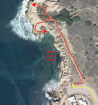
Fred and I left Greg and Paul at the car in the parking lot while we jogged up the trail to the tidal pool access point. This area on the western sided of Point Loma is referred to as the intertidal zone, a window into the ocean ecosystem that lies along of San Diego's coast. During periods of low tide, pools form along this shore in rocky depressions. In them you may see flowery anemones, elusive octopi, spongy deadman's fingers, and a myriad of other creatures. The tidepools are a wonderful discovery zone, but is also a very sensitive ecosystem. Few animals in this ecosystem can harm humans, but many animals are sensitive, and can even be killed, when handled or just touched.
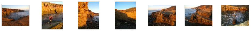
Unfortunately, we arrived here about midway in the tidal cycle, and you can only really appreciate the tidal pools at low tide. So while we could climb down the rocks to the shore, we couldn't walk out among the tidal pools. That was a bit of a disappointment, but such is life. We did get some wonderful pictures of the shoreline, and if you will click on the thumbnails below you can see some of them:

|
|
|
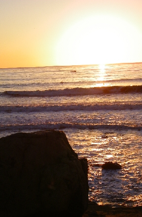
The afternoon was so nice, and the setting sun on the rock cliffs so beautiful, that I made a simple movie of the Pacific Ocean waves coming in across the tidal pools. |
|
As with most of nature's performances, words don't ever seem to do justice to spectacular sunsets. I guess we've all seen them, but this one was the most beautiful I'd seen in recent memory. I hope you will click on the thumbnail images below and have a look at six of the best pictures that Fred and I took of the sunset here off Cabrillo Point:
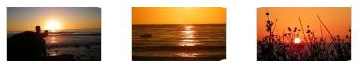
|
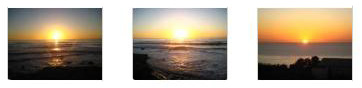
|
|
This movie is simply thirty seconds of the sun slowly sinking into the Pacific. You've seen the sight above; you might want to try the sight AND sounds. |
Well, today was certainly a nice tour of the coastal areas north of San Diego. We'd seen a lot and covered a lot of ground. The sun has set and Cabrillo NM has closed, so we are off back to the Sheraton and some relaxation. (I might take this opportunity to show you a couple of pictures of our room and bath.
Greg bowed out of dinner this evening- too much at breakfast, I think- and so Paul, Fred and I found a little diner-type place over in the university area where we had some comfort food. Then it was back to the hotel, some surfing on the Internet, and bed. (I did find out one nice thing when I checked my email- Greg, Fred and I had all been upgraded to First Class for our flight back to Dallas from San Diego. Paul was traveling a couple of hours earlier than us on Southwest.)
Our Trip Home
|
I had already taken Paul to the airport earlier, and Greg was going to take the hotel shuttle while Fred and I returned the rental car. We did that, and met Greg at the ticket counter for American Airlines. We got through security with no problem, and were in the waiting lounge well in advance of our flight.
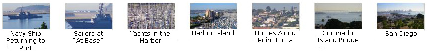
As usual, Fred was the photographer on the way home, and he got some good (and some very interesting) pictures. First, let's begin with his movie of our takeoff and climb out. You'll see our hotel, Point Loma, Cabrillo NM, downtown, a cruise ship, the Coronado Island bridge and some views inland:
|
Watch for many of the locations you've seen before as we take off from San Diego, circle out over Point Loma and Cabrillo NM, and head back east across the south part of the city. |
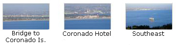
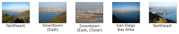
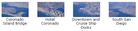
Next, click on the thumbnail images below to see some good still shots that Fred took after ending the movie you just watched:
|
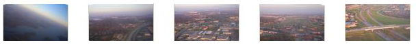
Now click on the thumbnail images below to see some of the best of the many pictures that Fred took enroute from San Diego to Dallas (look for the plane passing very close to us and the mysterious crop circles):

|
Finally, click on the thumbnail images below to see some of the pictures Fred took as we were coming in for a landing at DFW Airport in Dallas:
|
Paul was nice enough to bring Greg's car out to the airport to pick us up; he had arrived two hours earlier than we. By six-thirty Fred and I were back home. We'd been gone for just under a month, and with the time in Fort Lauderdale, the really great experiences on the cruise and our weekend in San Diego, it was really a trip to remember.
You can use the links below to continue to the album page for different day.
|
November 26, 2009: Thanksgiving |
|
November 2-21, 2009: Our Panama Canal Cruise |
|
Return to Index for 2009 |