|
November 20, 2010: Jack's River Falls (GA) |
|
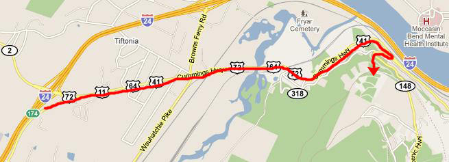
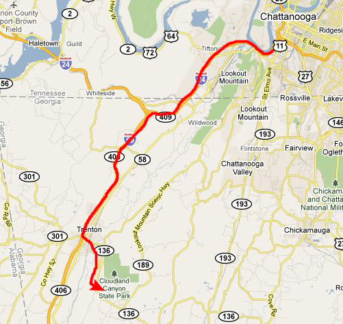
November 18, 2010: Driving to Chattanooga (TN) |
|
Return to the Index for Our Hiking/Thanksgiving Trip |
The first stop we've planned to make today is at an attraction called Ruby Falls- apparently the world's tallest underground waterfall. Fred has been there before, I believe, but I haven't, so it ought to be interesting. After that, we have some hikes planned at a state park south of where we are now.
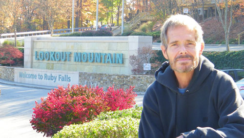
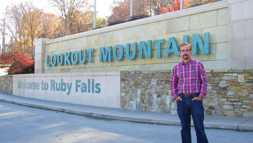
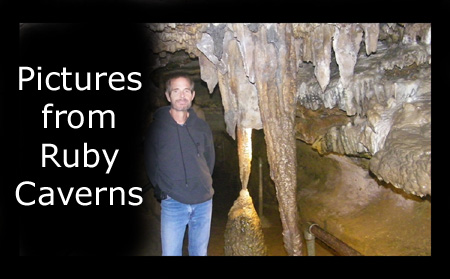
A Visit to Ruby Falls
|
|
History of Ruby Falls
In 1905, due to geographical limitations, the Southern Railroad Company was forced to construct a tunnel along the face of Lookout Mountain and through some portions of the mountain for one of its lines. This tunnel intersected and sealed off the natural entrance to the Lookout Mountain Cave. In doing this, the Lookout Mountain Cave was completely shut off to the public. Leo Lambert, a local cave enthusiast knew of Lookout Mountain Cave and its rich history and had even explored the cave prior to it being sealed off. He longed to reopen it to the public and devised a plan from which to do so. In 1923, Mr. Lambert along with a group of investors decided to enact his plan.
His idea was to drill an elevator shaft from another point on the mountain to access the cave from the surface above. Work on this feat of engineering began in the fall of 1928. On December 28, 1928, while excavating the elevator shaft a worker operating a jackhammer discovered a void in the rock and felt a gush of air. This void was located at the 260 foot level, still 160 feet above the Lookout Mountain Cave. Upon further inspection, an opening, 18 inches high and five feet wide, was discovered. Lambert, along with a small crew, entered this opening to explore the new found cave. While exploring they discovered a number of unusual and beautiful rock formations, flowing passages and several stream beds. Pushing their way deeper and deeper into the cave, they finally reached its marvelous jewel, the waterfall. Mr. Lambert and his exploration party were awestruck by it magnificence and beauty, and quickly returned to the surface to share their new found discovery with the rest of the crew. The round trip journey took them about 17 hours.
|
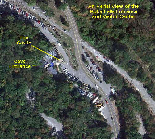
On his next exploration into the cave, Lambert took several people including his wife Ruby to see the many wonders they had discovered. While gazing at the waterfall, Lambert told his wife that he would name it in her honor, "Ruby Falls." Mr. Lambert decided to develop both the Lookout Mountain Cave and the new found Ruby Falls Cave to the public and offered tours to both caves. The entrance building for both tours was built from the limestone excavated from the elevator shaft and the cave trails. This entrance was touted as the "World's Most Magnificent Cave Entrance." It was named "Cavern Castle," and was modeled after a fifteenth century Irish castle. From 1930 to 1935 tours were offered to both caves, but Ruby Falls proved to be the most popular with its many unusual formations and of course the waterfall itself. In 1935, the Lookout Mountain Cave was closed to the public, but the Ruby Falls Cave has been open to the public continuously and has hosted millions of visitors during its long storied history. After nearly a century of tours through Lookout Mountain, Ruby Falls is as strong as ever.
The Geology of Ruby Falls and Lookout Mountain
|
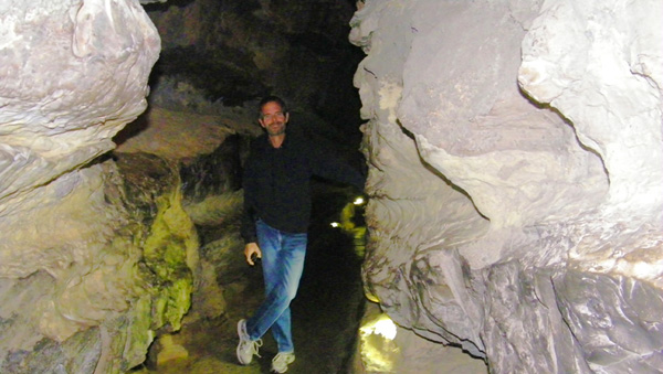
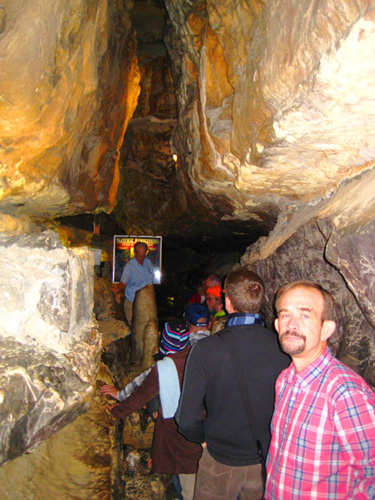
When our tour was called, we took an elevator down into the cave to what turned out to be a cavern room where there were some other folks waiting as well. (The elevator can't hold a whole tour of people.) Then our guide joined us and we started out. The first part of the trip to Ruby Falls traversed a number of rooms and passed a number of formations.
Formation of Ruby Falls Cave
|
At one time, the water table was much higher and the Ruby Falls Cave was at the top of it. Rushing water flowed through it for many years washing out the cave and enlarging the faults and cracks. The water table has since lowered and that explains the lack of water in the cave.
Formations in the Cave
Stalactites form as water drips from the ceiling leaving minerals behind. The minerals build up very slowly to make the stalactite. All stalactites start out as capillary tubes (also called soda straws). A capillary tube is a hollow stalactite. They are very thin and fragile. When the hold on the end of a capillary tube is closed off, it becomes a stalactite and begins to widen. Capillary tubes are very common in the Ruby Falls Cave, especially in the Hall of Dreams.
Stalagmites are formed by minerals deposited on the floor when the dripping water hits and leaves behind minerals. Stalagmites almost always form underneath stalactites. Columns are formed when a stalactite and a stalagmite grow into each other.
|
We took quite a few pictures of the formations that we passed on our way to the end of the underground trail at the falls themselves. I wanted you to see lots of these, and so to make that easy, I have put them in a slideshow.
To view the slideshow, just click on the image at left and I will open the slideshow in a new window. In the slideshow, you can use the little arrows in the lower corners of each image to move from one to the next, and the index numbers in the upper left of each image will tell you where you are in the series. When you are finished looking at the pictures, just close the popup window.
I took a few good movies as we were walking through the cave towards the falls:
|
This movie will give you a pretty good idea of what most of the walk through the cave was like- mostly narrow passages that occasionally opened out into larger rooms. |
I made this movie as we entered the larger room where the formation called The Leaning Tower was located, and I also included the formation called The Turtle in the movie. |
|
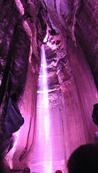
The Formation of Ruby Falls
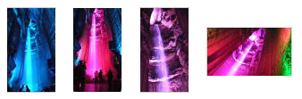
The falls were the end-point on our trek, and seemed to be in a cul-de-sac within the cave. When we got there, some of the earlier tour were still milling about, watching and listening to the waterfall. Over the pleasant sound of falling water the PA system was playing irritating Christmas music- spoiling the effect of the falls themselves. I didn't even like the colored lights that changed every ten or fifteen seconds.
But even considering all that, the falls were very pretty, and at least a few of Fred's pictures turned out. I have put thumbnails for four of them below; just click on the thumbnails to see the pictures:
|
|
If you can get past the irritating Christmas music playing in the background, you should enjoy this movie of Ruby Falls. |
We enjoyed our walk into the Ruby Falls Cave and to the falls; after about fifteen minutes at the falls, our tour guide herded us together for the return trip. (The trips are timed so that groups don't have to pass each other in the narrow corridors.) On our way in, there was a place where the walkway had divided- probably to allow tour groups to pass. On the way back, we took the other path.
|
When we took the other path on the way back, we were advised that there would be a music and light show on the formations, so I was ready to film most of it as we walked along. Very pretty. |
On the Observation Platform
|
This movie pans across the view from the top of the building and shows the valley where Chattanooga is located. |
Our time on the observation deck concluded our visit to Ruby Falls. Next on the agenda was to head in towards Chattanooga for lunch at a local barbecue restaurant and then on to our next stop down in Georgia.
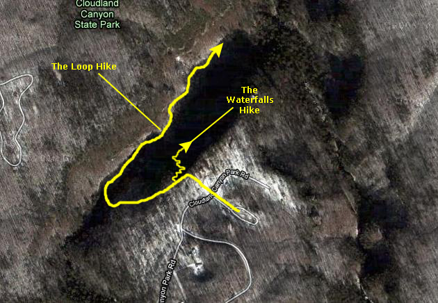
Hiking in Cloudland Canyon State Park
Getting to Cloudland Canyon State Park
|
We entered the park from the south after a short few miles up a winding road from Trenton, paid our entrance fee, and got directions to the trailhead for the hikes around the canyon. We were parked there in just a few minutes.
|
The other hike follows the Rim Loop Trail all the way around the southwestern end of the canyon and then back up along the northwestern side of the crevasse to an overlook from where you could look all the way back across the canyon to your starting point.
On the Waterfalls Trail
|
We are walking along the rim trail to the southwest, and are coming up on the fork that will take us onto the Waterfalls Trail down into the canyon. |
The trail to the right led us down a slope to a huge overhanging rock, and the trail led right underneath it. As it turned out, the rock was at the top of a stairway leading down; I went ahead of Fred to get that picture of him at the top of the stairs. Like some other hikes we've been on, this one would have a lot of stairs (representing a lot of work). Going down them was quick; coming back up them less so. Once again, I got a bit ahead of Fred so I could get a picture of him coming down the stairs.
|
Here is the movie Fred made of Cherokee Falls; it shows off his zoom to good advantage:
|
|
|
Here is the movie I made of Cherokee Falls and the area around it. |
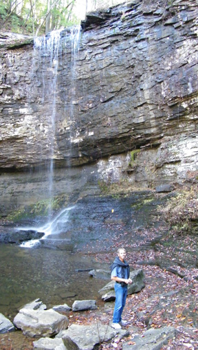
After sitting and admiring this waterfall for a time, we decided to continue on down to the trail to the next set of falls. Once again, most of the trail consisted of wooden stairs- lots of them.
|
Cloudland Canyon is, at this point, very narrow and with steep sides. There would be little way for the average hiker to get down to the falls without these constructed stairs. |
We continued down the trail past one pretty waterfall until we came out above Hemlock Falls. Once again, we followed the trail down around the falls and then down the slope to the area around the pool beneath the lower of the two sets of falls. Here, I took a picture looking back up the canyon at both sets of falls and at one of the two bridges we had to cross on the way down. You can have a look at that picture here. And when we were standing beside the pool, we set up the tripod so I could get this picture of Fred and I at Hemlock Falls.
|
This movie, made at the foot of Hemlock Falls, shows you both sets of falls, the pool and the area all around. |
Once again, since we'd made the trek down, we spent some time relaxing by the falls, but then we had to hike back up all those steps to reconnect with the Rim Trail so we could continue with the second hike here at Cloudland Canyon.
On the Rim Trail
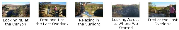
From the first overlook that we got to it was hard to tell just what was below us, but when we got around to the second, I could look back at the first overlook, and you can see the fencework sitting atop the column of rock. And from the last of the overlooks we could see the canyon rim continuing on around to the northeast. The views from the farthest overlook were pretty spectacular, and we spent almost an hour there just sitting in the sun and looking around. We took some really nice pictures from there, and if you will click on the thumbnails below you can have a look at them:
|
|
From the last Rim Trail overlook, where we had the best views, I made a movie panning around the entire canyon to try to point out some of the major features. |
There was still a lot of sunlight, but we knew the day would be fading fast, so we reluctantly left the overlook and retraced our route along the Rim Trail back to the parking area and our vehicle to head out of the park and find a place to stay for the night.
|
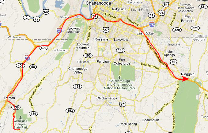
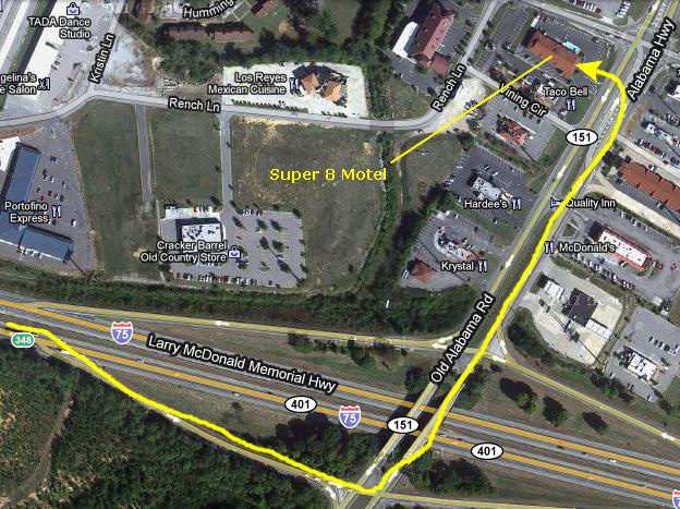
We left the park and drove back west a short ways to I-59, and then headed back towards Ruby Falls and Chattanooga. We got on I-24 east for a ways just past the city and then headed south on I-75. We saw a sign for a Super 8 motel in the town of Ringgold, Georgia. According to our directions, that would be the closest place to stay.
|
You can use the links below to continue to the album page for different day.
|
November 20, 2010: Jack's River Falls (GA) |
|
November 18, 2010: Driving to Chattanooga (TN) |
|
Return to the Index for Our Hiking/Thanksgiving Trip |