|
November 21, 2010: Northwest Georgia Waterfalls |
|
November 19, 2010: Ruby Falls/Cloudland |
|
Return to the Index for Our Hiking/Thanksgiving Trip |
The main stop Fred's planned for today is a relatively long hike to a place called Jacks River Falls. It is over in the Chattahoochee National Forest in northwest Georgia and southeastern Tennessee.
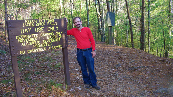
Getting to the Jacks River Falls Hike Trailhead
|
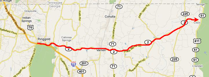
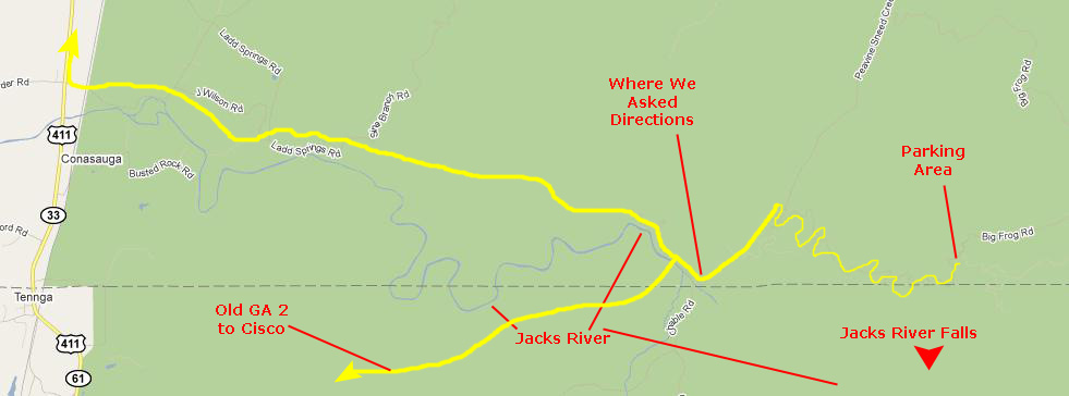
We stopped at a gas station to ask some directions to the falls; there were a father and son hunting party that had been to the falls before, and gave us directions to access the road back into the wilderness- which turned out to be the road pretty much across the street from the station. We headed off that road, which was called Old Georgia Route 2. After about four miles, the pavement ended and we were on a fairly good gravel road for the next five miles or so. We came to a T-intersection that was not marked, but our directions had been to turn right there. We went another few hundred feet and came to a small parking area at a trailhead.
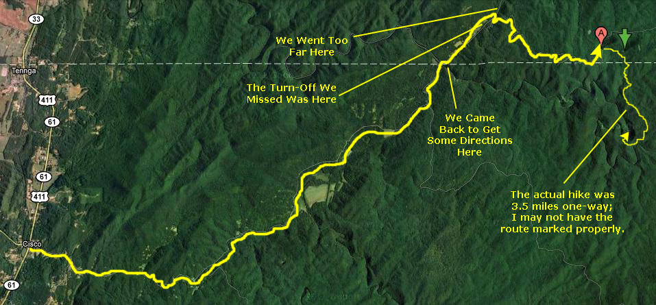
There were some other people there, so we asked if that was the trailhead to the falls. We were told that the falls were a good ways upstream and, while we could follow the Jacks River that was flowing by the parking area, the actual trailhead was further up the road. So we continued on Old Route 2. I saw that we passed a road that led up the mountainside to our right, but I didn't see a sign of any kind and so we continued on until it became obvious that we had gone too far.
So we turned around to head back and this time, coming from the other direction, I saw the sign for Forest Road 62- which was the one we wanted. We headed up that gravel road and stayed on it for 2 miles or so until we finally came to the parking area. We knew it must be right as there were quite a few cars there. The dotted line on the aerial view of all this below is the Tennessee-Georgia state line, so you can see that we had to go through Tennessee to get to the falls which are actually in Georgia:
|
I tried to mark the route that the trail took to get to the falls, but I may have the wrong location. I asked Google to pinpoint the coordinates for the parking area; those are the two location marks you see. I am guessing when I tried to mark the route our hike took. The hike was 3.5 miles one way, and, although I am pretty sure which canyon the falls were in, the route doesn't look that long as the crow flies. We did do a lot of up and downhill walking, and there were lots of switchbacks and curves, so maybe when you stretch out the route the distance is accurate.
The Trail to the Falls
|
|
Shortly after we left the trailhead, I filmed this movie of us hiking along on the broad trail. The trail was leaf-covered and the walking was pretty easy. |
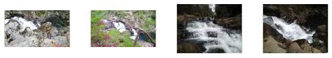
We hiked for about 2.5 miles along the trail through partially bare mountain forest. Every once in a while the view would open up and we could see some fall color. Early on, we passed a couple with a medium-sized dog; they weren't exactly following the trail but were going cross-country up and down the hillsides, but in the general direction of the falls. Their path intersected ours one more time, and we heard them a few times to one side or another. About a mile or so short of the Jacks River, we came across a small stream that flowed from our left down the gentle slope towards where the river must be. Over on the left, up into the woods a short way, the stream fell down a stairstepped waterfall. Presently, the trail leveled out and we could begin to hear the river faintly off in the distance. We continued along the trail until we came to an area where a bunch of people- maybe twenty or so- were tent camping right by the river (thus explaining the many cars in the parking area). And then we came to the Jacks River.
At the Jacks River and Falls
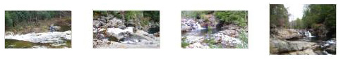
The Jacks River Above the Falls
|
|
When we reached the Jacks River, we were above all the falls- including the small upper cascade. I made a movie panning from upstream down across all of the falls and to the continuation of the river below them. |
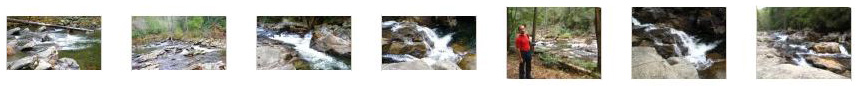
At the Upper Falls
|
Middle Jacks River Falls
|
|
When I had climbed down below the middle cascade, Fred was still on top of, and me made this movie panning from upstream, down the middle cascade and down to where I was making my own movie. |
This is the movie I was making when Fred filmed me in his movie above. I look back up at him and then film the middle cascade at the falls. |
Lower Jacks River Falls Cascade
|
|
Here is a movie of Jacks River Falls taken from the bottom of the major cascades, showing those and the pool below the falls. |
While we were standing around below the falls, I did an experiment, taking a series of pictures in a 360-degree rotation around the falls. Later, I stitched these pictures together into a panorama. You can see the result using the slider display window below. Just use the horizontal scroll bar to go back and forth around the panorama. You will begin just to the right of the falls and end up back at both cascades (panning across Fred as you go):
 |
The Jacks River Below the Falls
|
|
Our understanding is that it continues all the way back to the place along the road where we'd first asked for directions. Also from this vantage point downstream, we could look back and see almost all of Jacks River Falls. The sun was coming out more strongly, and the afternoon was getting quite nice, so we just hung around the falls for a while, eventually working our way back up above them to get a nice view of the Jacks River in the dappled sunlight.
In our walk along the river, we had come upon a place where a small creek flowed into it. From the direction it was coming, we surmised that it must have been the small watercourse that we had crossed on the trail down, and so instead of going back upstream and around the campground, we decided to just follow the little stream upward, hoping to find the trail again. We did tramp through the woods along the stream for a few hundred yards until, as we expected, we found the main trail again. We turned left this time and headed back up the three-mile trail to the parking area.
By the time we got back to the car, it was too late to try to get somewhere else to do another hike, so we thought we'd just drive in the direction of the hikes we wanted to do the next day, and stay somewhere when darkness fell- as it would do in less than two hours.
The falls hike was really neat- as have been almost every hike we've ever done (save for Dog Canyon out in New Mexico years ago where Fred got his eye poked from a cactus- causing us to cut a trip short).
Driving to Murphy, North Carolina
|
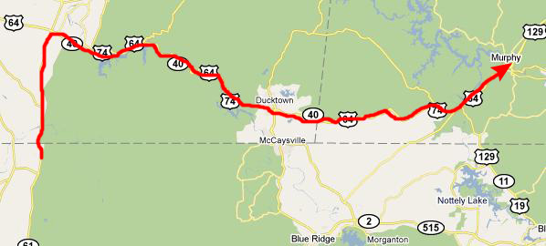
On this map, I have drawn in the roads we took; zooming in to see them made the map much too large. We got back to Old GA 2, and then went back around the curve where we had originally encountered the Jacks River and asked directions. Then we continued past the turnoff back to Cisco and continued northwest on one of the forest roads; a sign told us that it would eventually take us to US 411 north. It did- after eventually turning into Ladd Springs Road and winding first through an area of mountain cabins and homes and then, as we got out of the forest, farmland. We did get to Highway 411 and we turned north. Our next hikes were further east in the forest, but there was no forest road to get to them- at least not one that we wanted to drive on for two hours in the dark.
|
You can use the links below to continue to another photo album page.
|
November 21, 2010: Northwest Georgia Waterfalls |
|
November 19, 2010: Ruby Falls/Cloudland |
|
Return to the Index for Our Hiking/Thanksgiving Trip |