|
November 22, 2010: Amicalola State Park (GA) |
|
November 20, 2010: Hiking to Jacks River Falls (GA) |
|
Return to the Index for Our Thanksgiving Trip |
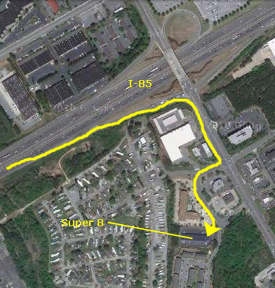
We are planning to do at least a couple of hikes today (more if time permits) and then end up in Atlanta for an evening visit with Jeffie and Michael.
Hiking the Raven Cliff Falls Trail
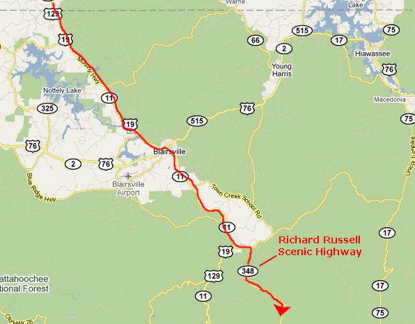
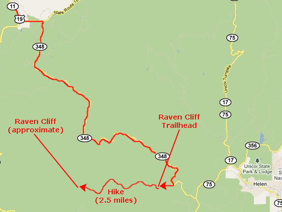
Getting to the Raven Cliffs Wilderness Area and Trailhead
|
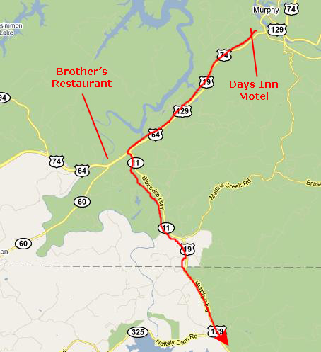
Having gotten his cutting, we headed west about four miles on US64/70 and found NC-11/US129 south- right near the restaurant where we'd eaten last night. We passed an interesting flea market right near the intersection, but didn't stop and continued south.
|
|
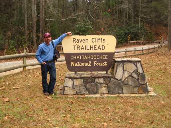
As it turned out, the trailhead parking area was quite sizeable and very well marked- it was just two miles beyond where we thought it would be. We parked in the lot where there were ten or twenty other cars, got our cameras and stuff, and were ready to head off on the trail.
Hiking to Raven Cliff
|
With more than 9,600 acres in its boundaries, the Raven Cliffs Wilderness Area is only accessed by hiking trails because developed roads are not allowed in nationally designated wilderness areas. Because of the size of Ravens Cliffs and the lack of human interference, the area has abundant bird life including grosbeaks, vireos, wild turkeys besides the ravens that give the area its name. Designated a wilderness area by the Forest Service in 1986, Raven Cliffs contains Smithgall Woods Conservation Area, Dukes Creek Falls Trail, Logan Turnpike, a portion of the Appalachian Trail, and Raven Cliff Falls.
|
As we were walking down the drive following the sign to the trailhead, I made a movie to record our starting off on the trail. |
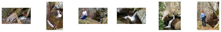
As soon as we got into the woods, we found that the hiking trail was going to be a really nice one- well-marked and easy to walk. There wasn't much up and down on this trail, but just enough to keep it interesting. This trail was a developed one, and occasionally we would find stepping stones over very tiny rivulets, and sometimes there would be a constructed wooden bridge over a gully or wash that would sometimes have water in it. This trail follows Dodd Creek through the Raven Cliffs Wilderness Area all the way to the end of the trail at the massive dark bluff near the headwaters some 2.5 miles from the parking area. And it wasn't very long at all before the trail dipped down to creekside and we began to see all kinds of rapids and small waterfalls.
|
No more than a tenth of a mile after we got on the trail, it dipped down to the first really pretty set of waterfalls, and Fred made this movie of them. |
While Fred was making the movie you just saw above, I was down closer to the same set of waterfalls making my own. |
|
|
After the first waterfalls a change in the trees became obvious, as the forest became dominated by hardwoods. All along the trail, short cascades and riplets of whitewater, like the ones in my last movie, produced a relaxing gurgle as we walked along, this sound continued during a significant portion of the hike. There were some small areas where the path was a bit slippery, as it had rained a day or two ago, but the path receives a "family" rating from most hikers, even though the Forest Service warns on the web site for this hike that the hike is steep in spots. That "steep" part of their comment can be misleading as most of the steep parts are in short spurts and easily taken even for a novice hiker.
|
To view the slideshow, just click on the image at left and I will open the slideshow in a new window. In the slideshow, you can use the little arrows in the lower corners of each image to move from one to the next, and the index numbers in the upper left of each image will tell you where you are in the series. When you are finished looking at the pictures, just close the popup window.
I took a couple more good movies before we reached Raven Cliff, and you can watch them with the players below:
|
This movie was taken from the bottom of the highest of the falls we saw on the creek before we got to Raven Cliff Falls themselves. |
I climbed up to the top of this highest waterfall and made a movie of the water coming down the creek and over the fall. |
At Raven Cliff
Approaching the Cliff and Falls
|
At Raven Cliff and Lower Raven Falls
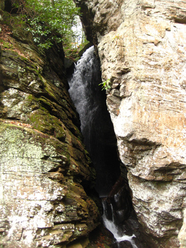
Dodd Creek flows down to the top of the attached portion of rock and then falls into the notch. There, it hits the sheer wall of the breakaway portion- the granite column- and makes a sharp left turn to flow through the notch itself. It comes out near where you can stand and look at it, hits another portion of granite and then makes a right turn to begin to descend that series of step falls and flow on down through the valley. At some point in the future, the water will wear the notch away further and perhaps cause the granite column to finally break off and fall in a downstream direction. Then, the notch falls will disappear to be replaced by a sheer, free-fall of some 70-80 feet. But I am sure that is way, way off in the future.
|
In this movie, taken after we climbed up about halfway from the base of the cliff to the notch, you can see Dodd Creek flowing in a series of waterfalls down alongside the cliff to the creek in the valley below. You can't see the notch yet, though. |
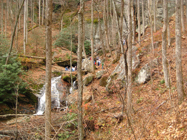
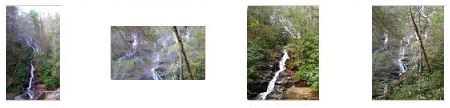
We climbed around beneath the cliff for a while, looking at the lower set of falls. At one point, I crossed to the other side of the falls, having to walk by a group having a picnic on top of a huge granite block. We took quite a few pictures, and if you will click on the thumbnail images below you can see some of the best of them:
|
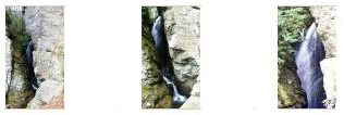
Raven Falls (the notch portion)
|
Below are some thumbnails for three good pictures that Fred took of the waterfall within the notch here at Raven Cliff Falls. Just click on the thumbnails to view the pictures:
|
|
Here is a movie taken from higher up the side of the cliff where we can look into and through the notch between granite columns and see the waterfall inside. |
My Climb Up Onto Raven Cliff
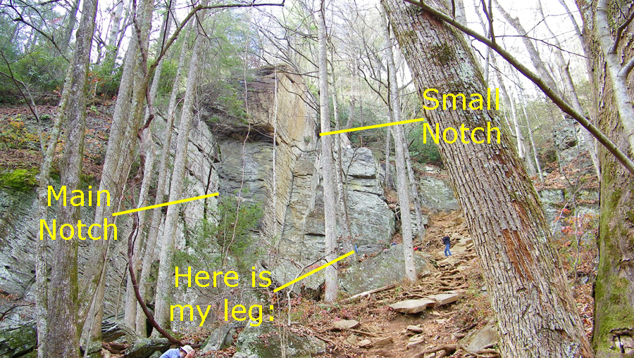
I began by climbing up the hillside above the notch, using rocks and tree roots as stepping stones and handholds as I needed to. It was not a difficult scramble, and soon I found myself looking a good ways back down to Fred at the notch. I continued climbing, and at one point I looked over at the granite cliff and I could see another, smaller notch where there was a large tree growing out of the side of the cliff. The tree and its roots looked as if it would provide a good way to get up, but from my vantage point I couldn't be sure, so I just continued up the hillside until I was even with the top of the granite cliff, at which point I encountered a path that a lot of people had eventually followed that led over onto the cliff.
Of course, when I came out on top of the rock column, the first thing I did was to walk as far out as I dared to see what I could see, but I couldn't get far enough to be able to look down on anyone. All I could bear to do was walk far enough to see the bare point of rock ahead of me. To get out there, I crossed what appeared to be solid, attached rock, but looking down to the side as I walked, I could see that I was actually crossing another fissure. If you look very carefully in that picture, you can make out the hole through the rock going almost straight down; at the far end you can see the green treetops below.
|
|
Here is a movie showing you these upper falls. You can only see them from on top of the granite column, although I suppose that if you circled the base of the granite promontory, you could see them from the other side.
When I came out on top of this rock, I could see that a small trail continued across the face of the hillside, and it seemed to lead over to these other falls, so I thought I would follow it to see where it led. After about a hundred feet or so of trail, I found myself at the very top of the upper falls, and there was an overhang where I could sit down and look at the water rushing by me and down these falls.
|
|
I spent a few minutes here just relaxing by the rushing water before I went back to the promontory to investigate what I thought might be another way down. You may recall that when I came up the hillside, I saw what looked like another little notch with a tree and tree roots to possibly provide a way up. Now, I wanted to see if it might be possible to get down that way. I went back to the promontory and I could look down through that little notch, and I thought I could see the same tree. So I went down a bit into that notch and indeed found that tree and its roots, and from this vantage point I could see how to use the roots to get down to where I could work my way across the hillside and back to the path I followed on the way up. So that's what I did, and it wasn't difficult at all.
Now, all this while, Fred had been down below waiting. In fact, he had just barely seen me when I was on top of the promontory, although he couldn't get a good picture. But he was observant enough to catch me emerging from the bottom of the tree's root system to work my way across the hillside. You'll never spot me in the picture, so let me point myself out to you:
|
Our Return Hike
|
As we were starting back, I went down off the trail to investigate the waterfalls below the cliffs. There were lots of little cascades, but nothing major. |
The return trip was just as pleasant as the hike to the falls, perhaps even more so as the sun had come out. We'd photographed most everything on the way in, so all we did on the way back was take a few movies.
|
As we started back to the vehicle, I took advantage of the newly-arrived sunshine to film the first part of our hike back through the woods. |
At one point, I thought we might have missed a turn, so I started looking for the cairns that people leave along trails to guide hikers. I finally found one, and you can see what it looks like here, and you can see a picture of Fred standing beside it here. |
As I said, the return hike was very pleasant, and we arrived back at the vehicle about an hour later.
Hiking the Dukes Creek Falls Trail
Once again, we collected our cameras and stuff and walked over to the trailhead that was right by the parking lot. Right by the trailhead we got our first view of the falls way off in the distance on the opposite side of a valley.
|
|
The Dukes Creek Falls Trail is a 1.9 mile round-trip hike in a series of three switchbacks that lead down to the falls on Davis Creek at its confluence with Dukes Creek. Originally, the trail dropped in a series of switchbacks directly from the parking lot. In 1996 the Forest Service constructed the current trail to view the falls from the opposite ridge.
History is no stranger to Dukes Creek. Hernando DeSoto visited the area in 1540, and at least one of his men returned around 1560 to mine gold in the area. Spanish miners continued to visit the area until the 1730s when Georgia became a colony. Their mines would be discovered during the "gold rush" that began in the area in the early 1800s.
At the end of the boardwalk the the trail begins a series of three well done switches. The first one slopes down below the highway and that stretch ends in a series of stairs down to the second. This second section follows an old road as it descends into the Dukes Creek river valley about 400 feet below the parking lot. This section continues past the stairway down to the third section which is the section that ends at the observation decks for the falls themselves.
When we got to the observation decks, we found that they were on two different levels. The top level extended straight ahead to offer a view of Davis Creek as it comes in from the northeast. A lower level of the observation deck offers a better view of Dukes Creek as it cascades down a very high rock face right in front of you.
|
|
This part of the Chattahooche National Forest is criss-crossed with many small creeks. For example, Dukes Creek is formed at the confluence of Bear Den Creek and Little Low Gap Branch some miles northwest of this spot. Dodd Creek, which we hiked along just a while ago, forms somewhat north of Raven Cliff, and of course forms the Raven Cliff Falls. It actually joins Dukes Creek about a mile upstream from where we are now. Davis Creek has its headwaters northeast of here. A short way downstream from this point, Dukes Creek enters Smithgall Woods Conservation Area. Miles later, it leaves Smithgall Woods, passes under Georghia State Road 75 and joins the Chattahooche River a mile after that.
|
|
|
|
The other set of falls down here was on the other creek that flows in to join Dukes Creek, and you can get your first look at these falls as Fred takes you down the observation deck to have a look at them. He starts by filming me on my way down to the lower platform. |
Before I go up and join Fred to look up Davis Creek, I wanted to get my own movie to show you the point where Davis Creek flows into Dukes Creek. I am still on the lower observation platform. |
Well, I was ready to head up to join Fred to look at the falls on Davis Creek, but before I left the lower platform, I took a picture looking up Davis Creek. Then Fred called down to me to sit still for a minute so he could take a picture of me on the lower platform with the confluence of the two creeks behind me. Then I walked up the stairs to meet Fred down at the end of the boardwalk where we admired the biggest of the falls on Davis Creek. While we were at the end of the boardwalk, I took a picture of Fred at the Davis Creek Falls and he took a picture of me.
|
While we were at the end of the boardwalk, I stopped to make a movie of the Falls on Davis Creek. |
We stayed down here at the end of the boardwalk for a while, and then got ready to head back. Walking back along the boardwalk, I noticed an interesting rock point across the creek and made a movie of it.
|
Across the creek we saw a promontory of rock jutting out from the bank, and growing on top of this rock, in seemingly very little soil, was a tree. Actually, I think the tree might have been dead, but it was still pretty large for the rock it was on. Very interesting. |
As we walked back along the boardwalk, I snapped a picture of the lower observation deck and, finally, a picture of Fred and the path back to the trailhead.
A Visit with Jeffie and Michael
We arrived at her stable after dark and quickly located her. She gave us a tour of the facilities, and we had a chance to see Logan, her horse, out in his paddock and meet some of her friends. I took some good pictures while we were here, and you can have a look at them by clicking on the thumbnails below:

|
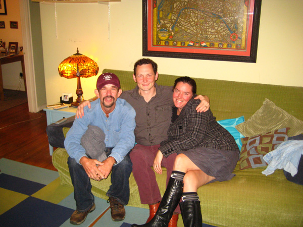
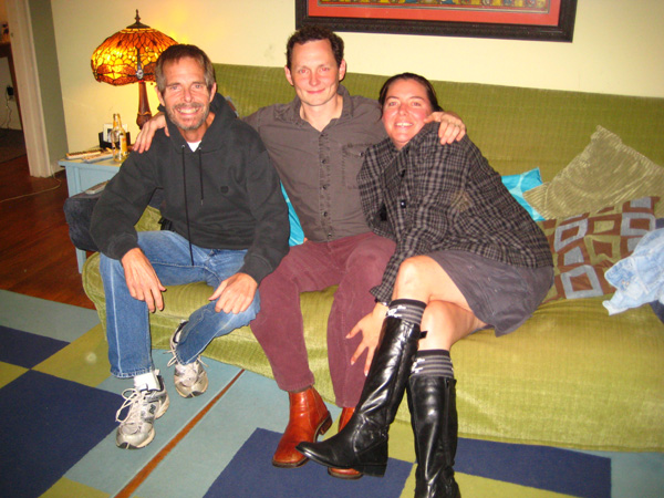
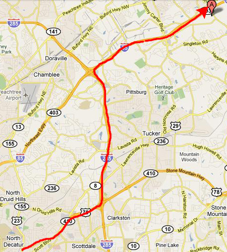
When we were done at the stable, Fred and Jeffie rode together and I followed them back to the apartment in Decatur where she and Michael live. We went to eat at a Mexican restaurant near their house and then came back to visit for a while. Below are pictures of Jeffie and Michael with myself and Fred:
|
|
We had a really nice visit with Jeffie and Michael, and left around eleven to head to the motel we'd reserved for the evening up in Norcross, Georgia. This would make it convenient for us to get to our main hike tomorrow.
|
|
You can use the links below to continue to the album page for different day.
|
November 22, 2010: Amicalola State Park (GA) |
|
November 20, 2010: Hiking to Jacks River Falls (GA) |
|
Return to the Index for Our Thanksgiving Trip |