|
November 23, 2010: South Mountains State Park (NC) |
|
November 21, 2010: Northwest Georgia Waterfalls |
|
Return to the Index for Our Thanksgiving Trip |
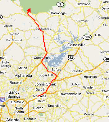
The main hike on the agenda for today is at Amicalola Falls State Park in the southwestern corner of the Chattahoochee National Forest about sixty miles north of Atlanta.
Getting to Amicalola Falls State Park
|
|
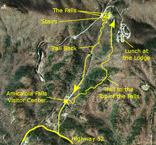
Leaving the Visitor Center from the back, we came out to the trailhead for the hike to the top of the falls. There are actually two ways to get there, so we picked the steep hike through the woods and up by the lodge to the top of the falls, intending to return on the other trail- the one that followed an incredible series of walkways and steps back down alongside the falls.
When we got to the parking area at the top of the falls (you can also drive to the top), we decided to walk up the short distance to the lodge and have lunch- which we did at a very good buffet that they had going. After that, we went back down the short trail to the park area at the very top of the falls, taking some pictures as we walked around. Then we began the stairway descent alongside the falls. At the bottom, the trail back to the visitor center continued (pretty flat this time) through the pretty woods in the afternoon sunlight.
That, in a nutshell, was our visit, so now we'll look at the pictures and movies we took today.
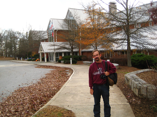
At the Amicalola Falls State Park Visitor Center
|
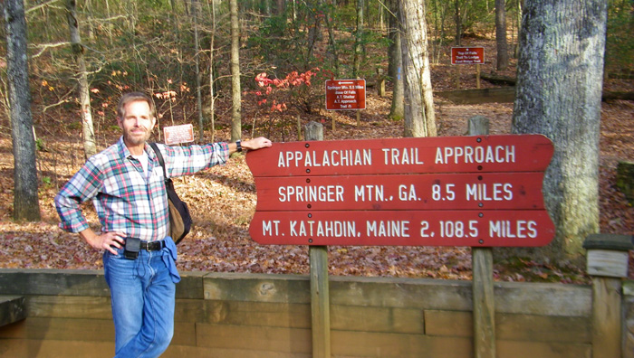
There, we found a picturesque stone archway that served as the gateway to the trails. We found that just beyond the arch, the trail to the actual beginning of the improved Appalachian Trail begins. Amicalola State Park is, apparently, the southernmost access point to the Trail, with a short, 8.5 mile hike to Springer Mountain, Georgia, which is where the actual Appalachian Trail begins. You can read the explanatory information about the Appalachian Trail here.
We wanted to do a nice hike today, but when we got out our pencils, paper and calculator, we discovered that it was unlikely that we could get to Mt. Katahdin, Maine, and back before dark. That's when we settled on the top of Amicalola Falls. To record the beginning of our hike to the falls, we switched off, with me taking a picture of Fred at the trailhead and him taking a picture of me.
Hiking to the top of Amicalola Falls
|
|
The trail was really pleasant for the first fifteen minutes or so, as we walked on a relatively slow upward slope through the leaf‑padded forest. There were a couple of wooden bridges on the way, and plenty to look at, but I discovered that I was overdressed for the heat of the noontime sun. The shady forest was a godsend, but it was still quite hot, and I took off my shirt for a while to cool off when we got to the top.
Along the way, Fred took some really nice pictures of the forest scenery, and you should click on the thumbnails below to have a look at them:
|
Lunch at the Amicalola Falls Lodge
|
|
|
At the Top of Amicalola Falls
|
We spent a few minutes here at the top of the falls, just standing on the bridge walkway looking out across the valleys below at the smoky hills and fall color. You can see a couple of nice shots of the view from Fred and I here and here.
Then we walked to the far end of the bridge to find the entrance to the stairway path down. Just before we began our descent, I saw a family with two little girls trying to take a photo of themselves with their camera. It appeared not to be working, so I volunteered to take a picture of the four of them with my own camera, which I did. Then I made a short movie to allow the father to tell me his email address. That night, I emailed the picture (and the movie) to them. I got a nice reply later that they had received it.
I took a couple of movies here at the top of the falls, and you can look at them using the players below:
|
In this movie, we walk out onto the bridge over the falls, and you can see the area around us, the stream going under the bridge and the top of the falls. | After we finished walking around at the top of the falls, I made a movie of Fred over by the entrance to the stairway path back down. |
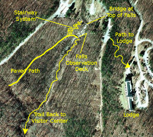
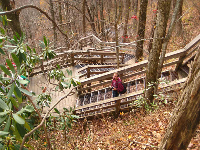
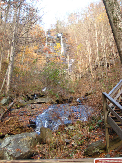
We can divide the return trip to the Visitor Center into three distinct parts. The first was the descent of the incredible stairway system from the top of the falls to a wheelchair-accessible walkway that leads across the face of the mountain to enable people to go from a parking area on the road to the top of the falls over to the observation platform for the falls themselves. The second part of the return trip would include our time at the falls themselves. Finally, the third part of the trip back would be the walk back to the Visitor Center from the falls. We'll divide the multitude of pictures that we took into these three sections.
Descending the Stairway to the Paved Path
|
Over at Cloudland Canyon, there were some stairway runs that exceeded forty steps. Here, perhaps because the park handles a lot more visitors, the stairs were built with short runs and many landings where people could stop and rest without blocking the stairs for others. In addition, most of the risers were of metal mesh, rather than wood, improving the traction in bad weather- again probably because this park gets many more visitors than Cloudland Canyon. So we applaud the State Park folks in Georgia for doing an excellent job here (as they have done at other parks we've been to in the state).
|
Not only were the stairs interesting to walk up and down, but all the way down to the bottom we could see Amicalola Falls over to our left. Once we got a ways down the hillside, we could see the main part of the falls; it was visually beautiful and the sounds of the water were a welcome accompaniment as we descended the stairs. Though there were other folks around, it wasn't crowded- and that made it nice, too. When we got close to the bottom of the stairway portion of the descent, we could see the bridge over the stream down below us, and close to the bottom Fred stopped to take a last picture of me on a stairway landing.
It wasn't just pictures on the way down; we both took some movies as well.
|
Near the top of the stairway system, Fred made a movie of Amicalola Falls and the stairs looking down. His camera zoom made the falls come alive, and, although parts of the movie are a little jerky (Fred moves his camera too fast when panning from side to side), it is an excellent introduction to the descent. |
Shortly after we got onto the stairway system, I thought it might be interesting to show you what going down them was like, so I just held out my camera in front of me as I followed Fred down the first part of the stairs. You'll feel as if you are walking along with us. |
|
When we got maybe a third of the way down, I could see ahead that there was a particularly intricate stretch of stairs, with people walking back and forth as if they were in a queue at DisneyWorld. Here is a movie of what that looked like. |
From one of the landings towards the bottom of the stairway, I could get great views of the falls, so I made a movie panning slowly down them so you can see them and listen to them. You'll also be able to see the observation bridge down below us. |
Below are thumbnails for some of the many good pictures that we took while descending the stairway system down to the paved pathway over to the observation bridge. Click on as many of these thumbnails as you wish to view the full-size pictures:
|
|
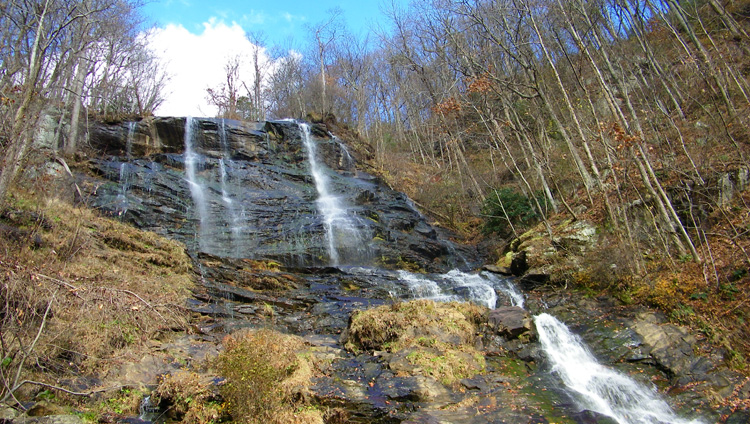
On the Amicalola Falls Observation Bridge
|
One of the first things we did when we got to the bridge was to make movies of the falls; Fred and I each made a movie of our own.
|
When I got to the bridge over the creek, and could look up at the falls, I made a movie to trace the watercourse from the top of the falls, down under the bridge and then on down the hillside towards the Visitor Center. |
Here is a little different view of the falls in a movie that Fred made. As usual, he puts his excellent zoom lens to good use to show the falls and the course of the stream down past where I am standing. |
The name of the falls comes from a Cherokee word, "amicalola," which means "tumbling waters." The creek that forms the falls here is called Amicalola Creek, but until the park was formed out of land sold to the State of Georgia in 1940 it was on private land, and its former name, if there was one, is unknown. At 729 feet high, Amicalola Falls is the highest cascade in Georgia.
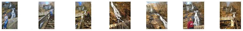
Both Fred and I took a lot of pictures on and around the observation bridge here at the falls, and we've winnowed them down to a relative few. There are thumbnails for these pictures below; just click on them to see the full-size image:
|
Here are some final movies of Amicalola Falls. In some respects, they duplicate the two previous ones, but you might want to take a look at them anyway:
|
Here is another movie of the top section of Amicalola Falls- from the precipice down to the observation bridge. |
This movie picks up at the observation bridge and shows the lower portion of the creek and falls. |
|
This movie simply focuses on the top portion of Amicalola Falls; you can watch and listen to the water cascading over the precipice. |
Hiking Back to the Amicalola Falls Visitor Center
|
When we got down a ways, the forest cleared a bit I could look back and zoom in on the upper stairway system, showing it winding its way upward through the forest. Amicalola Creek was our welcome and constant companion, and we took numerous opportunities to just sit down and commune with it. At a couple of these stops, Fred took my picture and I took his.
|
|
When we got to the bottom of the stairway system (where the sign you saw earlier was located), the trail continued along the valley floor, still paralleling the creek. The trail and creek wound through some campsites and group sites, until the creek reached a level area where it formed a small lake. We followed the trail around the side of the small pond to where the creek flowed out. At this point, it came alongside the park road.
Here, there were some stairs up to the park road, and here there was a trail sign directing us across the road to pick up the trail on the other side. There, we found that the next section of the trail was a boardwalk, as it appeared that this side of the road was usually wet and marshy. This boardwalk led along the road back to the Visitor Center, going up into the woods about an eighth of a mile before it ended back at the rear of the Visitor Center at the same point where we had started out five hours ago.
We found Amicalola Falls to be a really great place to visit, and we did a little of everything. If you are ever in the area, you should definitely stop in and experience it for yourselves.
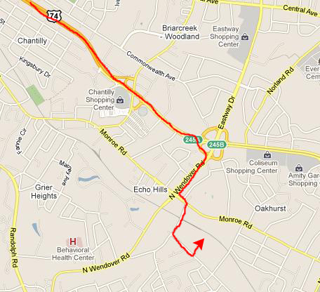
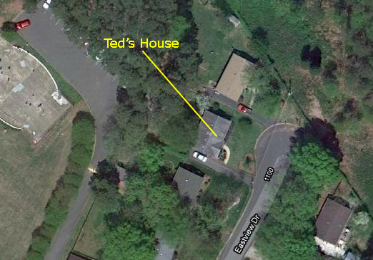
Getting to Ted's House in Charlotte
|
|
|
|
|
We got to Ted's about seven, talked for a while, and then went to get some supper over in Cotswold Shopping Center. Then Ted put us up for the night (thanks, Ted!).
You can use the links below to continue to the album page for different day.
|
November 23, 2010: South Mountains State Park (NC) |
|
November 21, 2010: Northwest Georgia Waterfalls |
|
Return to the Index for Our Thanksgiving Trip |