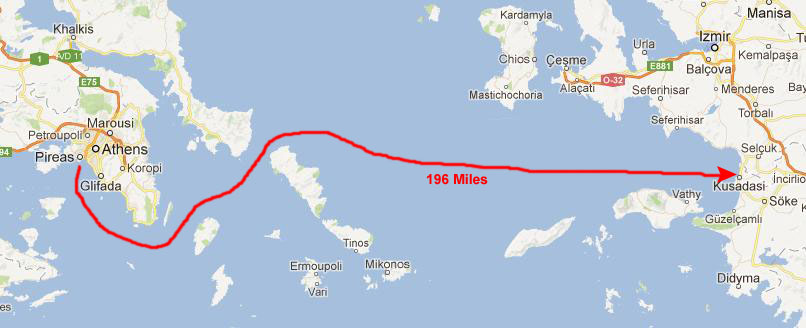
|
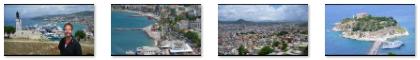
May 25, 2012: Santorini, Greece |
|
May 23, 2012: Athens, Greece |
|
Return to the Index for Our Mediterranean Cruise |
|
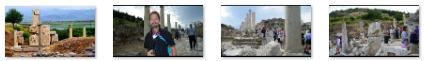
We'll also have some extra time after we return to the ship from the shore excursion to Ephesus, so we'll probably wander around the town of Kusadasi and soak up some local flavor.
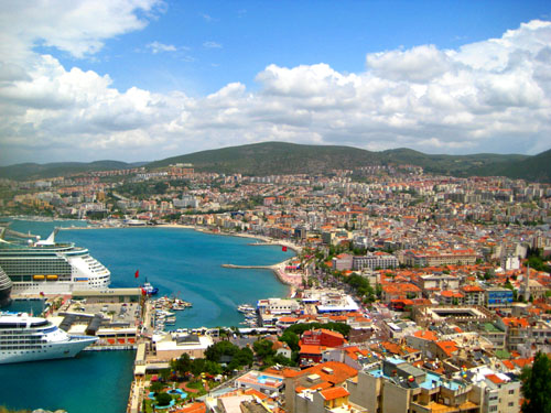
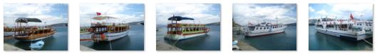
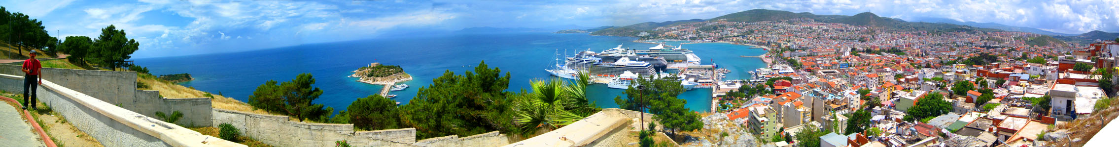
The Noordam Arrives in Kusadasi
|
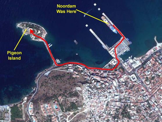
Kusadasi is a resort town on Turkey's Aegean coast and the center of the seaside district of the same name in Aydin Province. It is about 59 miles south south of the region's largest metropolitan center- Izmir. Its primary industry is tourism. The city stands on a bay in the Aegean with the peninsula of Guvercin Ada sticking out into the sea at one end, and the mountain of Pilav Dagi behind it. It has a year-round population of some 70,000, but this swells to over a half million in the summer with the influx of Turkish residents who maintain summer homes here, as well as tourists like ourselves.
We picked up our pilot and came slowly into the harbor. When were a couple of ship lengths from our dock, the pilot pivoted the ship around to back into the dock. We were abreast of Pigeon Island with its old fortress; we will visit it later in the day once we have returned from Ephesus.
As we backed into the dock, we could see another cruise ship already docked just south of us; you can also see the Ataturk monument atop Ataturk Hill in the background. We will go there later as well. We also got our first good look at the city of Kusadasi as well.
This area has been settled by many civilizations. The first-known were the Leleges (3000 B.C.). Later settlers included the Aeolians (11th century B.C.) and the Ionians in the 9th. Kusadasi was a minor port then; it was overshadowed by Ephesus- until Ephesus' harbor silted up. Subsequently, the area was ruled by the Lydians from their capital at Sardis, then the Persians (546 B.C.) and then, in 334 B.C., Greece (under by Alexander the Great). Rome took possession of the coast in the 2nd century B.C. and established a provincial capital. In the early years of Christianity, St. John the Evangelist and (according to Roman Catholic sacred tradition) Mary (mother of Jesus) both came to live in the area. As Rome declined, the port became a haven for pirates.
|
In 1834 the castle and garrison on the island was rebuilt and expanded, becoming the focus of the town, to the extent that people began to refer to the whole town as Kusadasi (bird island). However in the 19th century, trade declined in favor of Izmir- a railway was built through that town but it did not extend to Kusadasi. During the Turkish War of Independence the city was occupied first by Italian and then by Greek troops. The Turkish troops won control of the city on September 7, 1922, the Greek population left and native Turks moved in. Until the first holiday apartments were built here in the 1970s, Kusadasi was a fruit-growing rural district; these summer homes were built as housing co-operatives, with memberships sold to families in Ankara, Izmir, Denizli and other Turkish cities. From the mid 1980s Kusadasi grew again into the centre of mass tourism that it is today; the proximity of Ephesus has spurred that development.
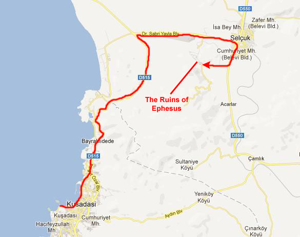
After we had breakfast, we assembled in the Vista Lounge for the departure of our tour group to Ephesus. We were off the ship by nine and following our tour guide along the pier to the waiting buses.
The Trip to Ephesus
|
|
|
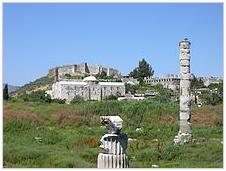
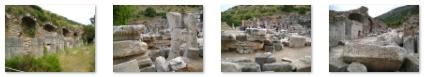
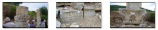
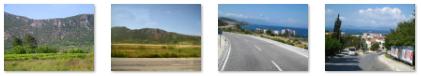
The bus eventually passed the Selcuk airport and then turned south in the center of Selcuk. We went for another mile or two and turned right onto the road that led to the south entry (not the main entry, as it turned out) for the Ephesus site. Apparently, we arrived just before the site opened for the day, so our tour guide handed out our tickets and we hung out just looking at the site over the fence. We weren't the only ones waiting, as you can see in the last picture.
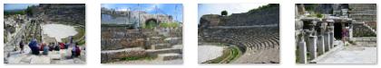
Our Tour of Ephesus
Ephesus was one of the seven churches of Asia that are cited in the Book of Revelation, and the Gospel of John may have been written here. The city was the site of several 5th century Christian Councils and is also the site of a large gladiators' graveyard. The archaeological site is a popular international and local tourist attraction, partly owing to its proximity to a major city and consequent easy access.
I thought I would include a condensed history of the city of Ephesus. It is interesting, but if you wish to skip it, just click here.
The area surrounding Ephesus was already inhabited during the Neolithic Age (about 6000 B.C.), as modern archaeological work has reveled. In recent years, settlements from the early Bronze Age were unearthed at nearby Ayasuluk Hill, and in 1954, a burial ground from the Mycenaean era (1500�1400 BC) with ceramic pots was discovered. Scholars believe that Ephesus was founded on the settlement of Apasa- a Bronze Age city noted in 14th-century B.C. Hittite sources.
The Period of Greek Migrations
|
The Greek goddess Artemis and the great Anatolian goddess Kybele were identified together as Artemis of Ephesus. The veneratio of this goddess led to the construction of the Temple of Artemis, one of the Seven Wonders of the World and the largest building of the ancient world according to Pausanias. Of this structure, scarcely a trace remains.
The Archaic Period
About 650 B.C., Ephesus was attacked by the Cimmerians who razed the city, including the temple of Artemis. After they had been driven away, the city was ruled by a series of tyrants. This led to a revolt, and a democratic council was set up. The city prospered again, producing a number of important historical figures such as the philosopher Heraclitus.
About 560 B.C., Ephesus was conquered by the Lydians under king Croesus. He treated the inhabitants with respect, despite ruling harshly, and even became the main contributor to the reconstruction of the temple of Artemis. His signature has been found on the base of one of the columns of the temple (now on display in the British Museum). Croesus brought outlying settlements together in the vicinity of the Temple of Artemis, enlarging the city. Later in the same century, the Lydians under Croesus invaded Persia. The Ionians refused a peace offer from Cyrus the Great, siding with the Lydians instead. After the Persians defeated Croesus, Cyrus then incorporated Ephesus and the other Greek cities of Asia Minor into the Achaemenid Empire.
Ephesus has intrigued archaeologists because for the Archaic Period there is no definite location for the settlement. There are numerous sites to suggest the movement of a settlement between the Bronze Age and the Roman period, but the silting up of the natural harbors as well as the movement of the Kayster River meant that the location never remained the same.
The Classical Period
Ephesus continued to prosper, but tax hikes led the Ephesians to participate in the Ionian Revolt against Persian rule in the Battle of Ephesus (498 B.C.), an event which instigated the Greco-Persian wars. In 479 B.C., the Ionians, together with Athens and Sparta, were able to oust the Persians from the shores of Asia Minor. In 478 B.C., the Ionian cities entered with Athens and Sparta into the Delian League against the Persians. Ephesus did not contribute ships but gave financial support by offering the treasure of Apollo to the goddess Athena, protectress of Athens.
During the Peloponnesian War, Ephesus was first allied to Athens, but later supported Sparta, which also had received the support of the Persians. As a result, rule over the cities of Ionia was ceded again to Persia. These wars did not much affect daily life in Ephesus. The Ephesians were surprisingly modern in their social relations. Strangers were welcomed, and education was much valued. Through the cult of Artemis, the city also became a bastion of women's rights. Ephesus even had female artists. In 356 B.C. the temple of Artemis was burned down by a lunatic, and the Ephesians at once set about restoring the temple and even planned a larger and grander one than the original.
The Hellenistic Period
|
As the river Cayster silted up the harbor, the resulting marshes caused malaria and many deaths among the inhabitants. The people of Ephesus were forced to move to a new settlement two kilometers further on, when the king flooded the old city by blocking the sewers. This settlement was officially called Arsinoea, after the king's second wife, Arsinoe II of Egypt. After Lysimachus had destroyed the nearby cities of Lebedos and Colophon in 292 B.C., he relocated their inhabitants to the new city. After a revolt against Lysimachus and his defeat by Seleucus I Nicator, the town was again named Ephesus and became part of the Seleucid Empire.
After the murder of king Antiochus II Theos and his Egyptian wife, pharaoh Ptolemy III invaded the Seleucid Empire and the Egyptian fleet swept the coast of Asia Minor, and Ephesus came under Egyptian rule between 263�197 B.C. When the Seleucid king Antiochus III the Great tried to regain the Greek cities of Asia Minor, he came in conflict with Rome. After a series of battles, he was defeated by Scipio Asiaticus at the Battle of Magnesia in 190 B.C. As a result, Ephesus came under the rule of the Attalid king of Pergamon Eumenes II (197�133 B.C.). When his grandson Attalus III died without male children of his own, he left his kingdom to the Roman Republic.
The Roman Period
| |
| |
|
When Augustus became emperor in 27 B.C., he made Ephesus the capital of proconsular Asia (which covered western Asia Minor). Ephesus then entered an era of prosperity, becoming both the seat of the governor and a major center of commerce. According to Strabo, it was second in importance and size only to Rome. By the year 100, the population of Ephesus was between 400,000 and 500,000, making it the largest city of the time in Roman Asia. Ephesus was at its peak during the 1st and 2nd centuries.
The city was famed for the Temple of Artemis (Diana), who had her chief shrine there, the Library of Celsus, and its theatre, which was capable of holding 25,000 spectators. This open-air theater was used initially for drama, but during later Roman times gladiatorial combats were also held on its stage, with the first archaeological evidence of a gladiator graveyard found in May 2007.There were several major bath complexes built while the city was under Roman rule and one of the most advanced aqueduct systems in the ancient world, with multiple aqueducts of various sizes to supply different areas of the city. They fed a multiple set of water mills, one of which has been identified as a sawmill for marble.
The city's splendor ended when it and its temple were destroyed by the Goths in 263.
The Byzantine Era (395-1308)
The emperor Constantine I rebuilt much of the city and erected a new public bath, and Ephesus once again flourished; it was second only to Constantinople in importance during the 5th and 6th centuries. Emperor Flavius Arcadius raised the level of the street between the theatre and the harbor and the basilica of St. John was built during the reign of emperor Justinian I in the 6th century. Unfortunately, the town was again partially destroyed by an earthquake in 614.
The importance of the city as a commercial center declined as the harbor, despite repeated dredging, was slowly silted up by the river; today, Ephesus is 7 miles from the nearest harbor. The loss of its harbor and access to the Aegean ruined Ephesus' importance for trade. The city began to decline as people left the city lowland for the surrounding hills. Beautiful temples were dismantled and the stone used in building new homes; marble sculptures were ground to powder to make lime for plaster. This decline was hastened by Arab incursions in 654, 700 and 716.
Seljuk Turks conquered Ephesus in 1090; it was by then only a small village. They kept control of the region until 1308. Crusaders passing through were surprised when they did not find the expected city and seaport. Even the temple of Artemis was completely forgotten by the local population.
The Turkish Era
The town was conquered in 1304 by Sasa Bey, and the town knew again a short period of flourishing during the 14th century under these new Seljuk rulers. They added important architectural works such as mosques, caravansaries and Turkish bathhouses. The Ephesians were incorporated into the Ottoman Empire for the first time in 1390. The Central Asian warlord Tamerlane defeated the Ottomans in Anatolia in 1402, and the Ottoman sultan Bayezid I died in captivity. The region was restored to the Anatolian Federation but, after a period of unrest, the region was again incorporated into the Ottoman Empire in 1425. Ephesus was eventually completely abandoned in the 15th century.
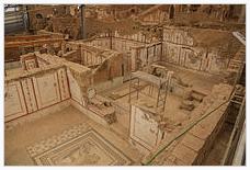
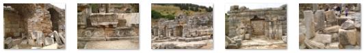
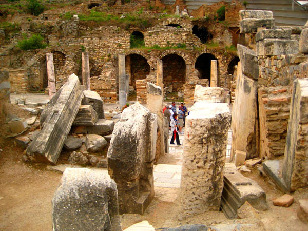
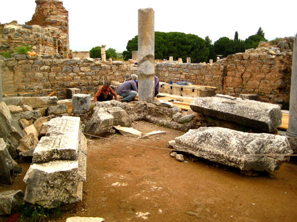
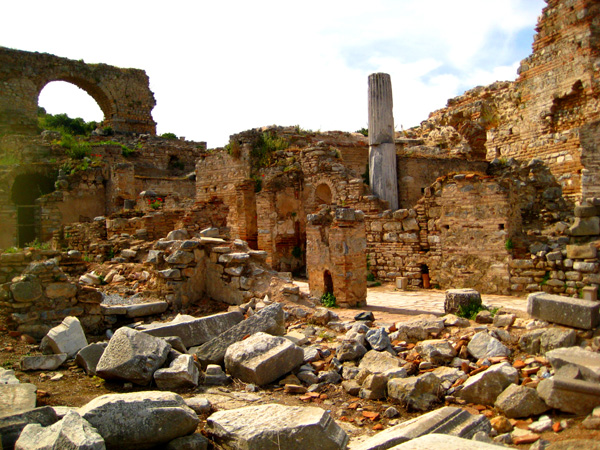
When the ruins site opened, our tour (about thirty of us plus our guide) entered as a group. We remained together for the first half hour or so, but then Fred, Greg and I found that the informative signage allowed us to wander about at our own pace. We were separated from each other occasionally as each of us found sites within the complex to explore in detail. I, for example, spent a great deal of time in the Odeon, at the Celsus Library and in the Great Theatre.
|
Before we get going on the tour, you might be interested to see an artist's recreation of what the city may have looked like in one of its normal (not severely damaged) periods. I have put that image below:
|
If you compare this recreation to the diagram above, you can see the general layout of the site is the same, and you can mentally mark the route we took through the complex on the recreation.
|
|
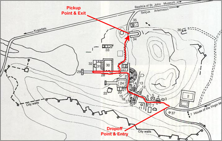
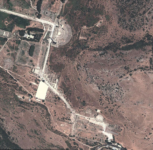
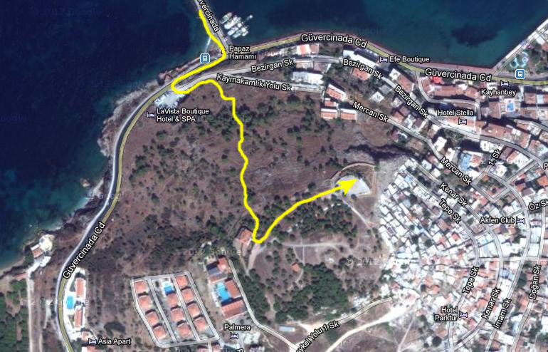
I have put a reduced-size version of this aerial view at left. The actual view is a composite of a number of sections taken from Google Maps and stitched together with the Microsoft Image Composite Editor. (It is free from Microsoft and does an amazingly good job of stitching together- compositing- various images. It works better than Photoshop, and I heartily recommend it.) This view is too large to show all at once, so I will do again what I have done before- put the image in a separate, scrollable window that you can leave open during our (and your) tour of Ephesus.
|
You can simply minimize this little window as you read through this page, bringing it back up as desired, and finally closing it when we are done here at the ruins site. I think the aerial view is interesting, but it is, of course, optional. That said, open the aerial view, scroll to the lower right corner, and we'll start through the Ephesus site.
Entering the Ephesus Site
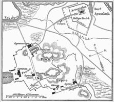
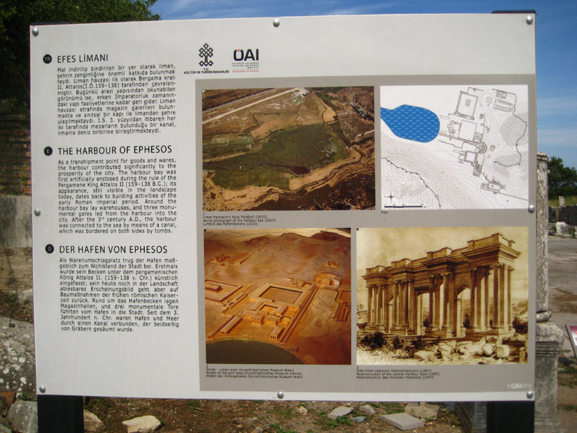
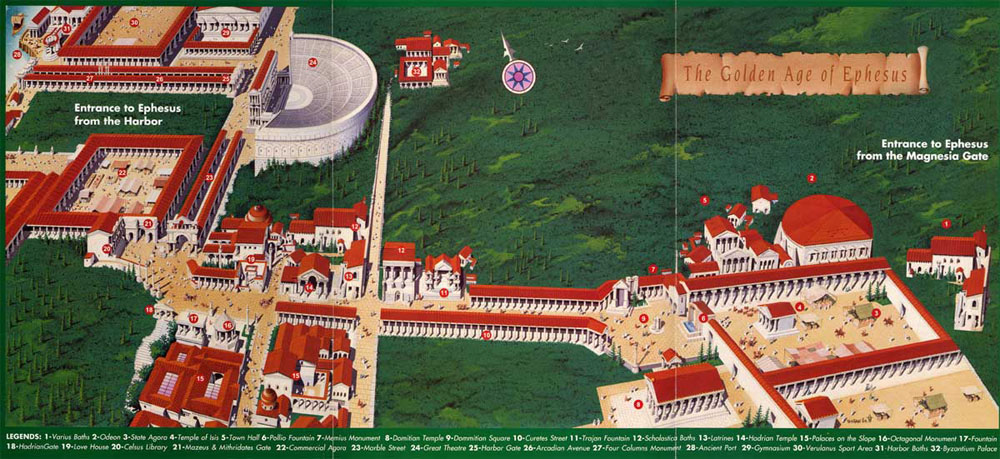
There were four large signs, one for each of the major periods in Ephesus' history. Each sign had some narrative describing the site during that period and also some photographs or diagrams. For each of those signs, I am going to put a group of links below- one for the narrative and one for each of the diagrams. You can use these links to read the signs or look at the diagrams:
|
The Early Ephesos (Late 7th millennium - 334 B.C.) The Early Ephesos - Narrative Early Find Locations in Ephesos - Diagram Mythical founder Androclos (frieze from Hadrian's Temple) - Photo |
|
The Hellenistic Ephesos (3rd - 1st century B.C.) The Hellenistic Ephesos - Narrative The City Walls of Ephesos - Photo The Geological Topography of Ephesus in the Hellenistic Period - Map |
|
Roman Ephesos Roman Ephesos - Narrative Panoramic View of Ephesos - Widescreen Photo |
|
Byzantine Ephesos (4th - 14th century A.D.) Byzantine Ephesos - Narrative Harbor Gymnasium with Byzantine Residences - Painting Curetes Street with Early Byzantine Honorific Statues - Photo Course of the Byzantine City Wall c. 600 A.D. - Diagram Byzantine Palace with Medieval Graveyard - Photo |
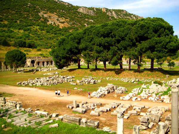
On entering the site, our tour group moved first to the northern edge of the open area at the entry to pause in front of the sign that displayed a map of the site and marked the various ruins.
|
|
You can watch my movie with the player at left, and then we'll head off to the first structure.
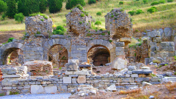
The Bath of Varius
|
|
It is built of cut blocks of marble. It has three sections, frigidarium (cold water), tepidarium (warm water) and caldarium (hot water). The excavations have not been completed yet. There are clickable thumbnails below for some additional pictures that Fred took of the baths complex; these show the frigidarium and tepidarium.
|
I also put together an interesting panorama that covers all three sections of the Baths of Varius; it is below:
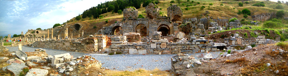 The Baths of Varius |
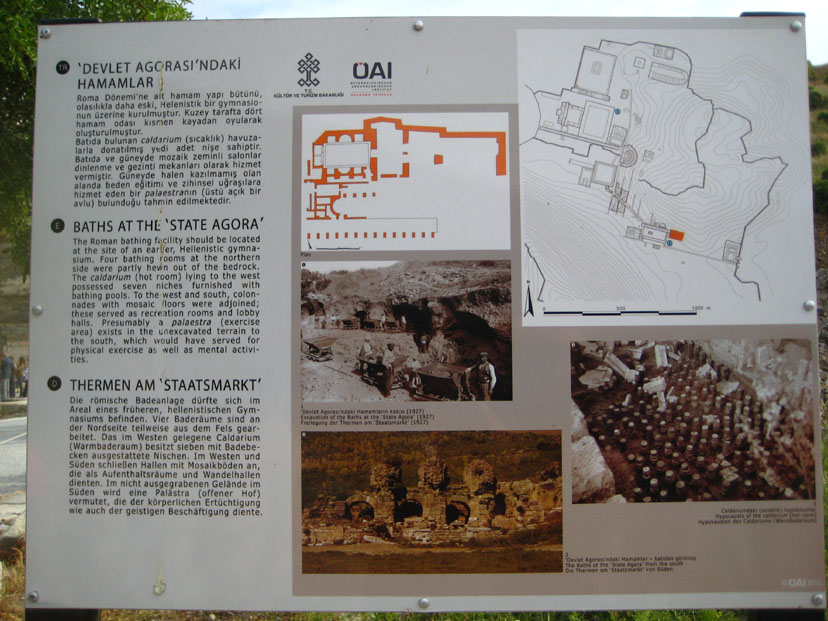
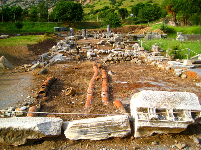
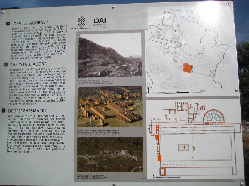
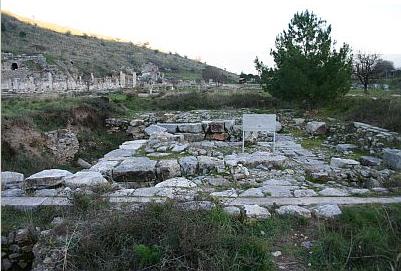
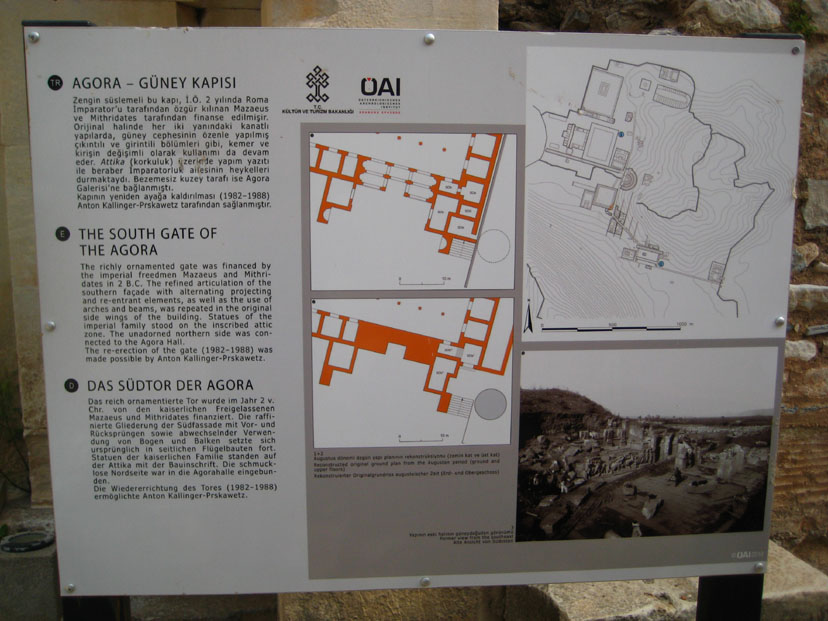
The State Agora
|
|
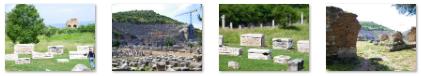
During the excavations in the northeast corner of the Agora, archaeologists found a great number of graves from the 7th-6th centuries B.C., a stone-paved road and a archaic sarcophagus of terra cotta. From this it is understood that in the archaic period this part of the Agora was used as the necropolis of Ephesus. There is a water reservoir at the corner of the Agora; this reservoir was an essential part of the city's infrastructure. Its water was brought to the city through the Pollio Aqueduct, the remains of which can be seen a few miles away along the Selcuk-Aydin highway. A large number of terra cotta pipe fragments have been uncovered at Ephesus; these are piled up in one part of the Agora.
The agora is approximately rectangular, 500 by 250 feet. There were stoas on three sides and a temple, dating from the first century A.D., in the center. The temple was dedicated to Isis; it had ten columns on its long side and 6 on the short side. It collapsed during the reign of Augustus and was not re-built because the Emperor disliked anything Egyptian. On the facade of the Temple, there were groups of statues describing the legends of Odysseus and Polyphemos; these are now displayed in the Ephesus Museum.
Piled around the Agora were remnants of the buildings that once existed here, and I took a few additional pictures looking around the area. There are clickable thumbnails for some of these pictures below:
|
The Temple of Isis
|
Isis was known as being the goddess of magic and healing, and ancient Egyptians believed that the Nile flooded every year because of her tears of sorrow for her dead husband, Osiris. He was killed by her other evil brother, Set, god of chaos and destruction. Unlike other Egyptian deities, she did not have a centralized cult at any point throughout her worship. She did, however, have a wide following, a following that dates to the Fifth dynasty of Egypt and which became widespread late in Egyptian history, when it began to absorb the cults of many other goddesses. It eventually spread outside Egypt throughout the Middle East and the Roman Empire, with temples dedicated to her built as far away as the British Isles. Worshipping of her remained in Christian Europe as late as the 6th century.
Isis gave the hope of eternal life or resurrection; in Anatolian religions this idea gained popularity because there had been no belief in an afterlife before her. Today the name Isis is still a beloved name among modern Coptic Egyptians, and in Europe the name Isadora is very common.
The Temple of Isis in Ephesus was destroyed during the reign of the Emperor Augustus because of Augustus� hostility towards Anthony and Cleopatra. Some of the parts of this building was used for the construction of The Pollio Fountain, and all that remains now are the general outlines of the foundation, shown in the inset picture, and an inventory of stone blocks that archaeologists believe were once part of the structure. Some, like the lintel blocks shown here, had relief figures carved in them.
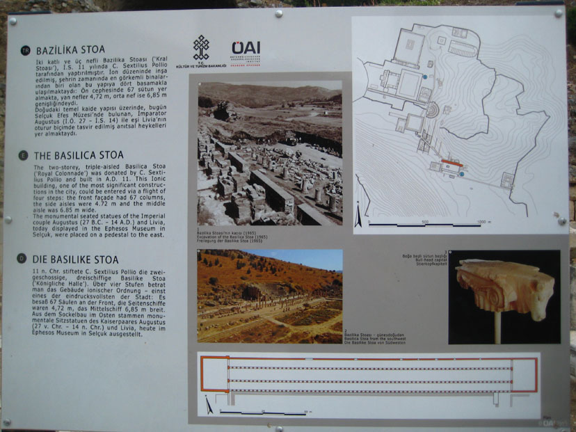
The Basilica
|
|
The basilica was used for stock exchange and commercial business. Meetings of the law courts were also held there. It has three gates opening onto a stoa leading to the Bath of Varius. The statues of Augustus and his wife Livia were found at the east end, and now they are displayed in Ephesus Museum. Archaeologists believe that the Basilica was rebuilt for the last time during the reign of the Emperor Agustus. It was destroyed by an earthquake in the middle of the Fourth Century A.D.
The basilica must have been an impressive structure, judging from the column fragments that remain. In some of the column fragments that are no longer standing, you can see up close that there were some kind of interior supports that held the column segments in place- kind of like ancient rebar. I did get a nice picture of Greg and Fred at a basilica column.
We took a number of other interesting pictures of the impressive columns that were part of the Basilica, and I have put clickable thumbnails below for some of these:
|
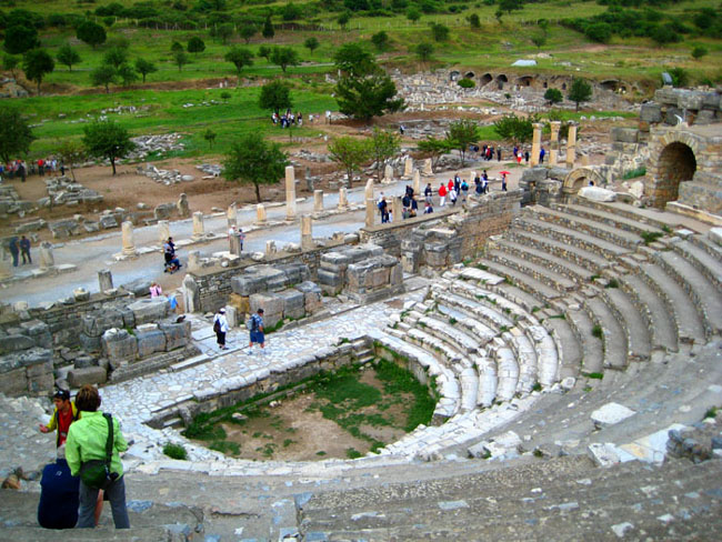
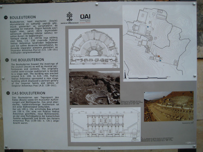
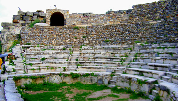
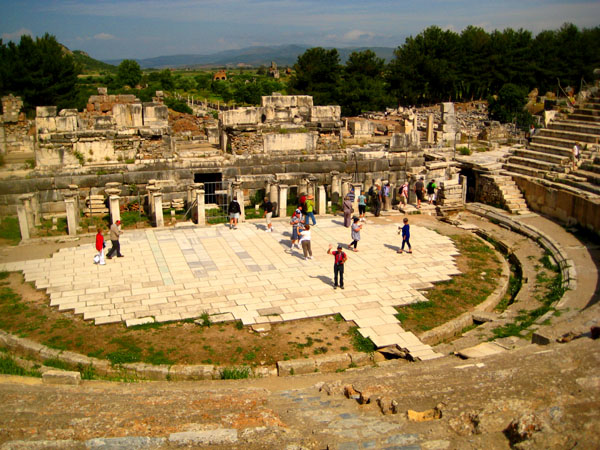
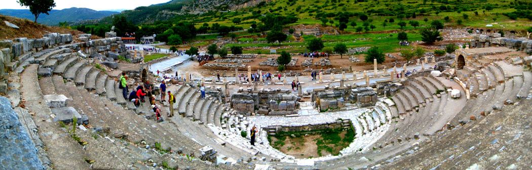
Odeon (Bouleuterion)
|
|
Getting into the Odeon was interesting. First, we walked a bit west along row of columns of the basilica and then we turned right into a passageway. At this point, we were going north through two long walls that ran east-west. These, apparently, were part of the structure of the building that once existed behind the Odeon stage. Atop these walls were rows of carved animals- quite a bit the worse for wear. Once through those two walls, we found ourselves in the southeast corner entry to the Odeon itself. This was another passage that led to our left. In front of us were the stairs leading to the upper levels of seating- more on that in a minute. To our right was an archway, presumably leading back towards the bath of Varius but now it is blocked up.
Before heading upstairs, I followed the tour group further west through this passage, and just before entering the stage area of the Odeon, Fred turned to get a photo of the passageway we had just come through. At the west end of this passageway, we went up a few steps and through an arched doorway to come out onto the stage area of the Odeon.
From the stage area of the Odeon, we had a great view of the entire structure, and we spent some time here with our tour guide listening to her explanation.
|
As I said, we gathered around our tour guide listening to her explanations (much of which you read on the information sign). As we listened, I snapped a few pictures of the tour group and the Odeon itself; there are clickable thumbnails below for some of these pictures:
|
At the end of our guide's presentation, I realized that she was not going to lead the tour up the stairs we had passed so we could get views from above, so when she beckoned the tour to follow her out of the Odeon, I realized I'd have to go up on my own.
|
The Odeon as Seen From the Stage |
One difference between the Odeon here in Ephesus and some of the other Roman theatres we have visited (such as the one in Cartagena) was that there were interior stairways at both ends of the three-tiers of multi-level seats that provided access to the upper levels- much like a modern symphony hall or sports stadium. You can see the openings where these stairways come out into the upper levels both at the beginning of the movie at left and in some of the inset pictures in this section. Other theatres in the ancient world used the same design, but this was the first one we have visited that allowed us access to these interior stairs, so of course I wanted to try them out.
So taking one last look at the Odeon as seen from the stage, I turned to return along the entry passageway to the stairs we'd seen earlier.
This Odeon had a capacity of 1500 spectators. It had 3 doors opening from the stage to the podium. The podium was narrow and one meter higher than the orchestra section. The stage building was two-storeyed and embellished with columns. The podium in front of the stage building and some parts of the seating have been restored. At some sites, this structure was open-air, but here at Ephesus the archaeologists have concluded that at one time this structure was enclosed with a wooden roof.
|
Climbing the Interior Access Stairs |
When I came out of the stairway, I was looking across the "orchestra pit" towards the west end of the Odeon, and I could see the stairway opening that I would eventually use to go back down. You can see the view that I saw here.
The Odeon was constructed in the 2nd century A.D. by the order of Publius Vedius Antonius and his wife Flavia Paiana, two of Ephesus' wealthier citizens. I went ahead and climbed up to the walkway above the cheap seats to walk around to the back of the amphitheatre. Along the way I took some good pictures looking down, and I have put clickable thumbnails for some of them below:
|
The Odeon at Ephesus had a double function. First it was used as a Bouleuterion for the meetings of the Boulea or the Senate. Two councils administrated Ephesus. These were Demos or parliament which was open to the public; meetings of the Demos were held in the Great Theatre that we will visit later. The other council was the Bouleia, the members of which were chosen from the aristocratic class of Ephesians. The most important decisions and city matters were discussed in this body, whose meetings were held here.
The second fuction of the Odeon was, of course, as a concert hall for performances. From my position at the back of the theatre and just above the top row of seats, I had an excellent view of the theatre and the valley beyond. I also took the opportunity to create a panorama from three separate pictures, and you can have a look at the result below:
 A Panoramic View of the Odeon |
|
The Odeon at Ephesus |
Having watched that movie, I should comment on an inaccuracy in my narration. From early this morning, I had been under the impression that the Ephesus ruins encompassed basically what we could see from the entrance. I mentioned something like that in the narration, that I had panned across just about the entire site. I had not stopped to think that our tour schedule had us away from the Noordam for another three hours, and if what I was looking at now was all there was, our trip home was going to be an awfully slow one.
As it turned out, what we've seen so far was, by my calculation, only about a fifth or sixth of the ruins here, and in terms of interest and amazing structures, we'd only scratched the surface, so there is a lot more coming up. Not knowing that at the moment, though, it was time for me to try to rejoin the tour, and so I decided to make my way down the seats in front of me and across to the west stairway that you can see at the upper right of my view here.
So I started down the stairs in front of me to work my way over to the right and the exit.
|
Leaving the Odeon at Ephesus |
I came out at another arched doorway that led out of the Odeon to the west, and it was when I went through that doorway, and found that ahead there were at least as many ruined structures as we had already seen that I realized there was a lot more to Ephesus than I had assumed. Fred wasn't with me just now, but I do have three pictures that he took when he exited a few minutes ago with the tour group. In the left hand picture, the stairs come out where the man in the white shirt is, and in the right hand picture that's me photographing something up close. Use the clickable thumbnails below to see these pictures:
|
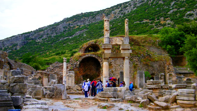
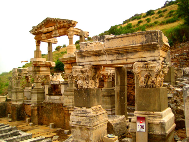
The Temenos (The Temples of Dea Roma and Divus Julius Caesar
|
The temples were erected to demonstrate that the Ephesians had a good relationship with the emperors; apparently, flattery can get you somewhere if you are an Ephesian. There was an altar serving the worship of Artemis and Augustus.
Below are clickable thumbnails for some other views of the area where these two temples once stood:
|
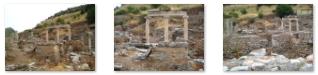
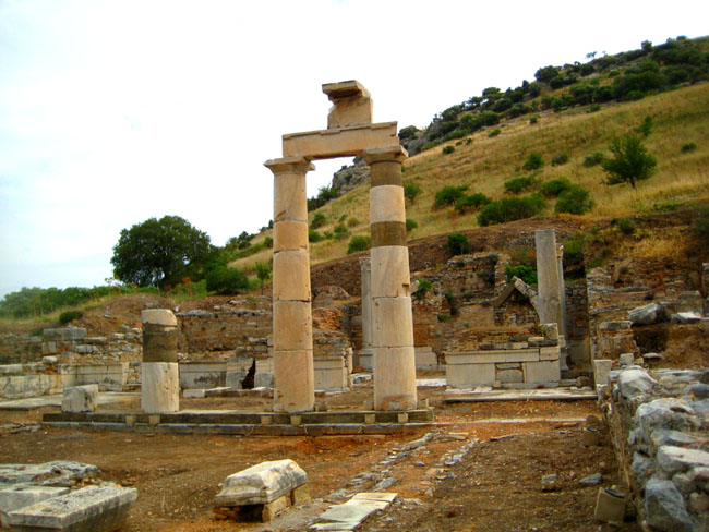
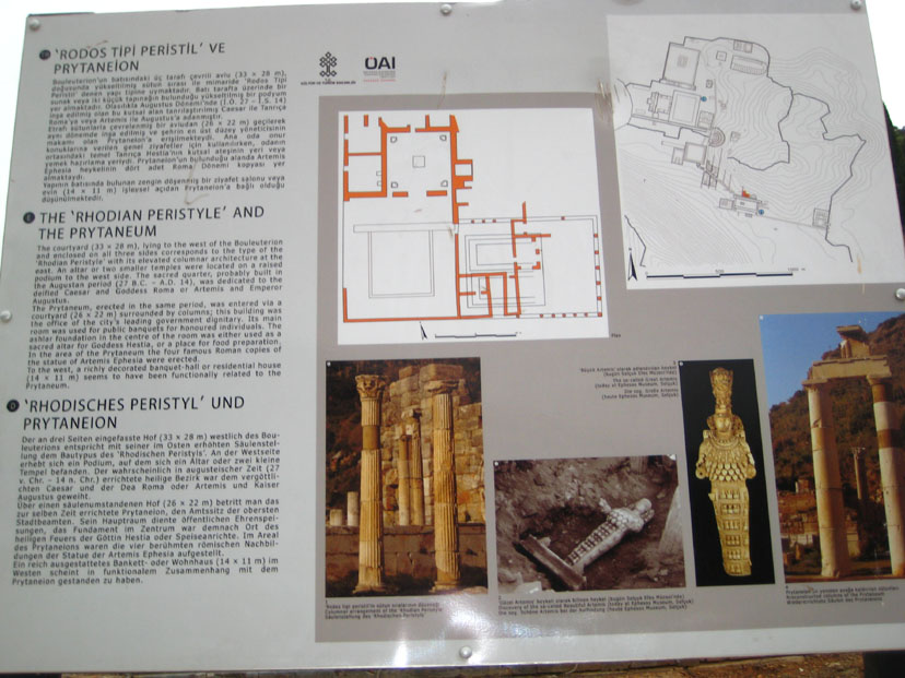
The Prytaneion
|
|
The four-cornered pit in which the sacred fire is burned is a relic from the reign of Lysimachos. In the front of the building were four columns, and beyond the columns was a courtyard surrounded by a portico. North of that was the center of the building, the ceremonial hall, and its side rooms. The eternal flame was here in the center of the ceremonial hall, the red color on the floor determined the location of the flame. Towards the back, there was a large area with wooden roof; the base of an altar is still recognizable today.
The double columns in the corners of the hall (shown at right in the picture here) held up the wooden roof. During excavations, archeologists found 2 artemis statues, which are now presented in the Ephesus museum.
|
|
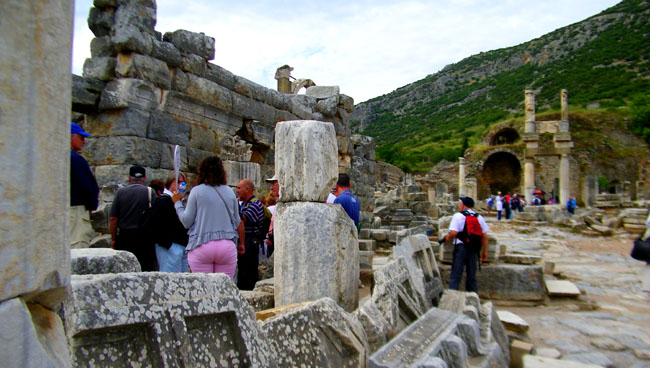
From the Prytaneion, we continued west along the pathway through the ruins- which of course had been a main thoroughfare in the ancient city. Earlier, I mentioned that I had thought the ruins at Ephesus consisted of those we could see from the entry plus the Odeon and the temples beyond. But when we left the Prytaneion and I saw the view ahead (which extended all the way to the Celsus Library), I realized that these ruins were much, much more extensive that I had imagined.
So we headed down the long, sloping path with a retaining wall on one side and ancient columns on the other. You can see what this was like by using the player at right to watch my movie of our progress. Our next destination would be down at the end of that retaining wall and off to the left- Domitian Square.
Domitian Square
|
The area contains a great deal of material from ruined structures, such as these remnants (which have, of course, simply been piled up by the archaeologists). Below are clickable thumbnails for some pictures taken along the street and turning into the Square:
|
Even aside from the individual sites, walking around the square was interesting.
|
Looking Around Domitian Square |
Since will be looking at each of the sites in Domitian Square individually, and so pictures of the square are rather less important. But some of those we took turned out well, so I thought I would include a few here. There are clickable thumbnails below for these views:
|
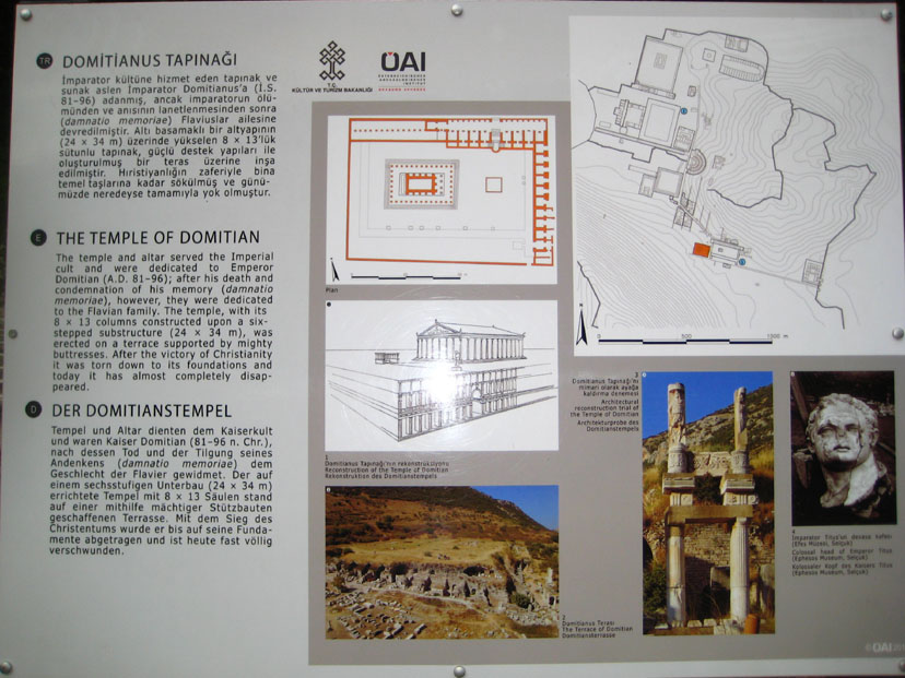
The Temple of Domitian
|
|
The temple, built in a prostyle plan, had eight columns on the short side and thirteen columns on the long side, and four additional columns in front of the cella. At the northern side there was an u-shaped altar, which is now displayed in the Izmir museum. From column to column, there were carved stone arches like these that have been recovered and set out for viewing.
Domitian was, in fact, the first Emperor to give permission for a temple to be built dedicated to an Emperor- himself, of course. This was the first such temple in the Roman Empire (called a "neocoros" temple, or "first temple for a given purpose"), and it was a great honor for Ephesus to be the site for it.
The workmanship was pretty amazing, and even now, two millenia later, the intricate carvings on the stone work are still in relatively good shape, as you can see if you use the clickable thumbnails below to see some of Fred's pictures of the temple:
|
I also took some pictures of the stonework and carvings on and around the Temple of Domitian, and there are clickable thumbnails below for some of my pictures:
|
However, when the unpopular emperor was killed by his servant, the public quickly took vengeance and erased his name from many inscriptions- not only here in Ephesus but throughout the Empire. However in order to not lose its "neocoros status," the Ephesians did not alter this temple, but simply re-dedicated it to Vespasian, the father of Domitian.
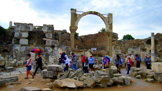
The Fountain of Pollio
|
|
The water was brought to the various fountains of Ephesus from three main sources through aqueducts and distributed from fountains by a branching system of baked clay pipes. The sources were the Kencherios River near Kusadasi, a village stream near Marnas and the Cayster River. The most distant was the Kencheiros- 25 miles away. The city provided water free of charge at these fountains, which were not only refreshing places to be on hot summer days, but places where residents could bring clay pots to collect water for use in individual dwellings. Because of this, the fountains were centers around which residents naturally gathered.
The Pollio Fountain has a high arch facing the temple of Domitian. This arch clearly demonstrates the construction methods that were used two millenia ago; the principle of the arch having been discovered millenia earlier. You can see this detail here (as well as the metal bars added in modern times to stabilize the structure).
It was known to be decorated with a number of statues. One of these statues is the Head of Zeus which is on display in the Ephesus Museum today. Some of these statues were thought to be taken from the Isis Temple, probably after an earthquake, and used to repair the fountain. The statue group of Odysseus and Polyphemus, that once were on the fountain's basin, are now on display in the Ephesus Museum.
|
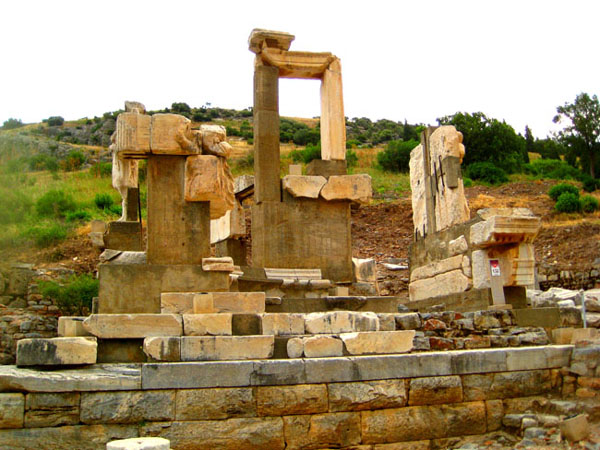
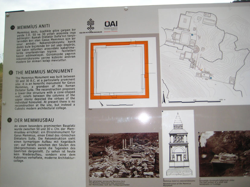
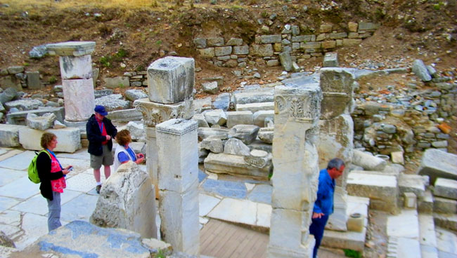
The Memmius Monument
|
|
Sulla was a hero for the Romans in Ephesus. When taxes rose continually in Ephesus, the Ephesians finally decided that they should free themselves from the yoke of Rome. They needed a miracle and that miracle came in the form of Mithridates of the Pontic Empire on the Black Sea Coast. His famous motto was �Asia for the Asiatics�. He killed 80,000 Romans with his army. But three years after the conflict with Mithridates began, the Roman army, under Sulla's, conquered him and brought security. This monument was built to remind the Ephesians of these events of 87 B.C.
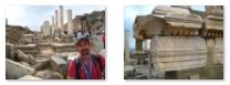
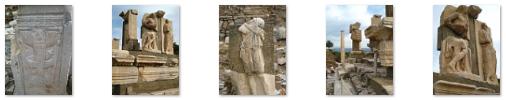
I took a number of other pictures on and around the Memmius Monument, and you can have a look at them using the clickable thumbnails below:
|
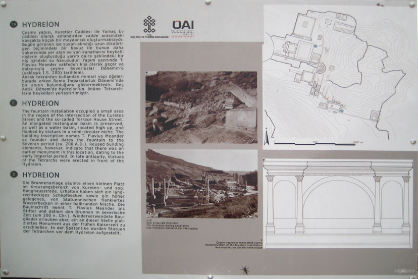
The Hydreion
|
|
We did not take many pictures of the ruins of this ancient fountain, but Fred and I did photograph the detail of some of the carvings on the various blocks lying around. You can see a few of these pictures here, here and here.
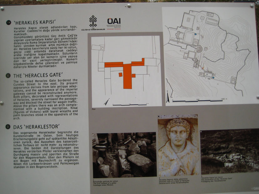
The Hercules Gate
|
|
The gate was actually brought from somewhere else; it was not constructed here. Although this was done in the fourth century A.D., the relief on it dates to the second century A.D. Only the two sides of the columns remain today; the other parts of it have not been found. The relief of the flying Nike in the Domitian Square is thought to also be a part of this gate.
Below are clickable thumbnails for three more pictures of the stonework at the Hercules Gate:
|
The Hercules Gate narrowed the access to the street, preventing the passage of carriages. This had the effect of turning Curetes Street into one of the earliest pedestrian malls on record.
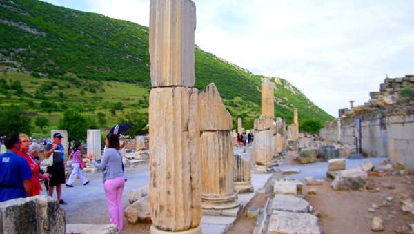
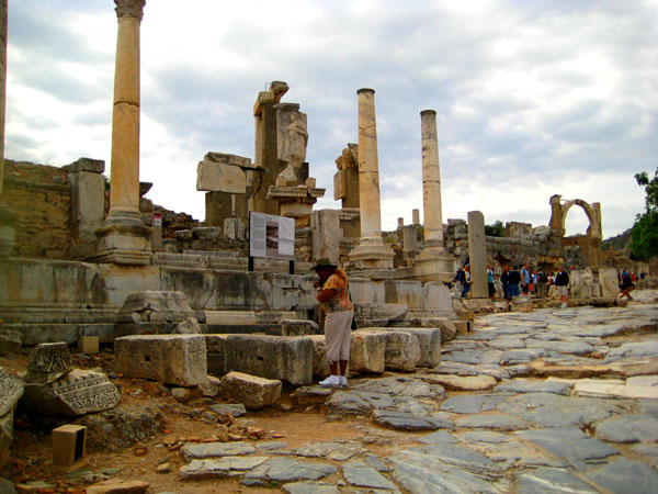
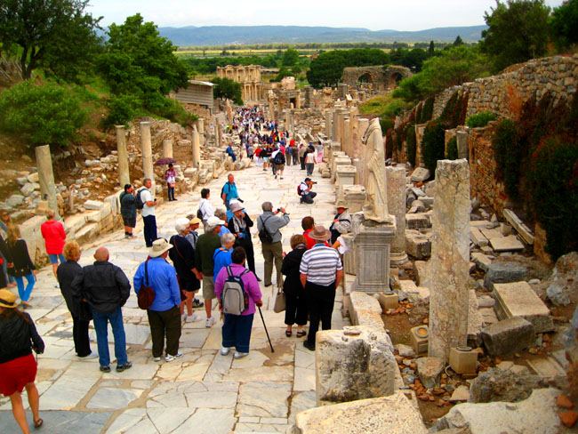
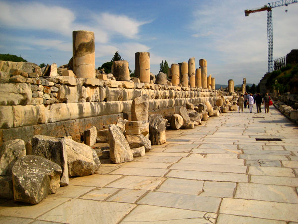
The Curetes Street
|
|
There were fountains, monuments, statues and shops on the sides of the street. The shops on the south side were two-storied. Ephesus had many earthquakes, in which many structures, including those along the Curetes Street were damaged. These earthquakes frequently damaged the columns that lined the street. For a while, these were repaired when earthquakes damaged them. But, after the major earthquake in the 4th century, the columns were replaced by the other ones brought from different buildings in the city. The differences between the design of the columns can be seen today. The street has been restored to evoke the appearance it had in the 4th century.
There were also many houses along and above the street on the slope; these were, by and large, the homes of the wealthiest of the Ephesians. Under the houses there were colonnaded galleries with mosaics on the floor; these were located in front of the shops with a roof to protect the pedestrians from sun or rain.
The street was immensely interesting, and as we walked down towards the library, we each took a number of good pictures of the street, the columns and the many different carvings on the various building pieces that had been set beside the street for viewing. There are clickable thumbnails below for some of these pictures:
|
|
The Fountain of Trajan
|
The pool itself was 60 by 30 feet and surrounded by columns and statues. These statues were Dionysus, Satyr, Aphrodite and the family of the Emperor. They are now in the Ephesus Museum. This site is currently under restoration, a process which is still ongoing. From the description, though, it must have looked like a movie set.
Below are clickable thumbnails for some of our other pictures of the Fountain of Trajan:
|
|
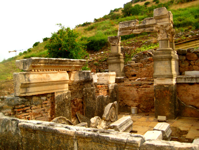
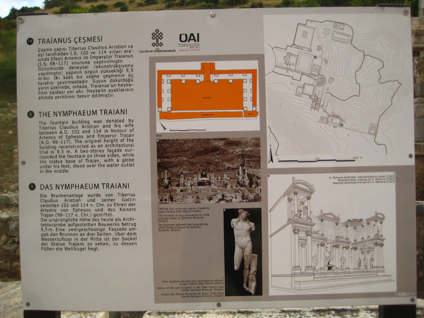
The Nymphaeum Traiani
|
|
The 35 foot by 15 foot rectangular fountain pool was framed on three sides by a facade that was originally about 20 feet high. There was, apparently, a lower floor something similar to a basement, and then two floors above ground. The method of construction formed a large niche in which a statue of the emperor Trajan was erected. Other statues adorned the two floors.
The water flowed under the statue (at the feet of the emperor) to enter the fountain; the main basin was preceded by a smaller basin along the street, and citizens could take water from that basin for their own use.
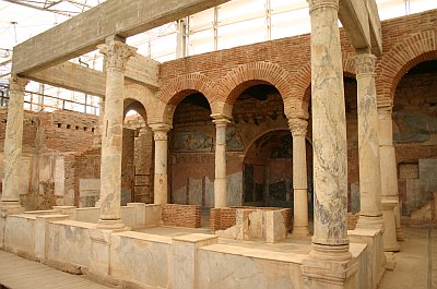
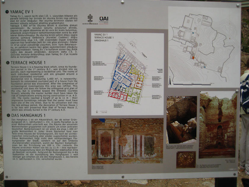
The Terrace Houses
|
|
There are six residential units on three terraces at the lower end of the slope of Bulbul Mountain. The oldest building dates back into the first century B.C. and continued in use as residence until the 7th century A.D. (And we consider a 100-year-old house to be an historical landmark!) The Ephesus terrace houses were covered with protective roofing in the Roman style. There were mosaics on the floor and the frescos on some of the walls. The excavations began in 1960 and elements from some of the ruined houses have been consolidated into the most complete of the remaining ones, and the structure opened to the public as a museum.
The residences had interior courtyards (peristyles) in the center, with the ceiling open. They were mostly two-storied, but the upper stories have all collapsed. On the ground floor there were living and dining rooms opening to the hall, and upstairs there were bedrooms and guest rooms.
The heating system of the terrace houses were the same as that in baths. Clay pipes beneath the floors and behind the walls carried hot air through the houses. The houses also had cold and hot water. The rooms had no windows, but were illuminated with light coming from the open hall; even so, most of the rooms were quite dim.
|
The Baths of Scholastica
|
Below are clickable thumbnails more more views of the various rooms:
|
|
Baths were used not only to bathe but also to socialize and discuss the topics of the day. The importance of discussing in the bath is well-known and effective in developing the Roman philosophy. The custom of Roman baths was continued during the Byzantine era and with the arriving of the Turks reached its heyday. During the times of the Ottomans, it won another dimension. Traditional Turkish baths are a direct descendant of the original Roman and Greek practices.
|
|
|
|
It's hard to select the best pictures sometimes; most of the ones we took here at the baths were interesting in one way or another. Below are clickable thumbnails for some more of mine:
|
|
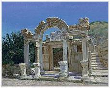
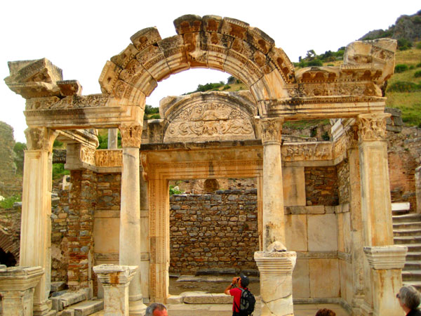
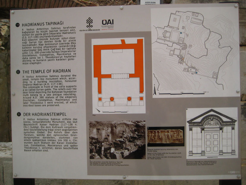
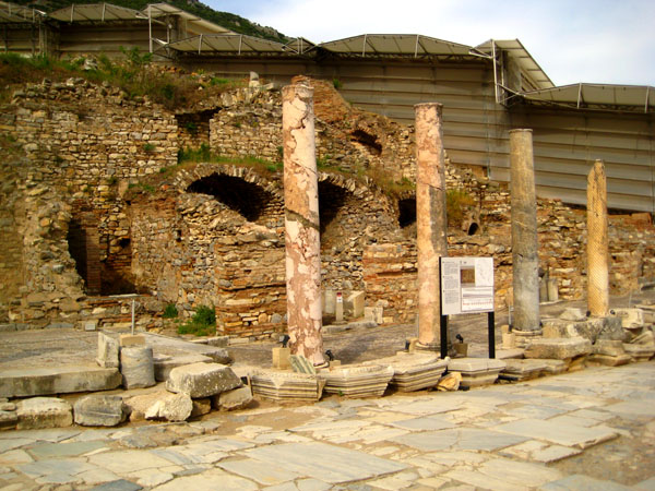
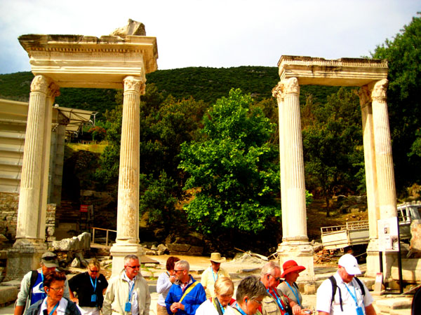
The Temple of Hadrian
|
|
Inside the temple and above the door, a human figure (probably Medusa) stands with ornaments of acanthus leaves. On both sides there are friezes depicting the story of the foundation of Ephesus- Androklos shooting a boar, Dionysus in ceremonial procession and the Amazons. The fourth frieze portrays two male figures (one of which is Apollo), Athena (goddess of the moon), an unidentified female figure, and Androcles and Hercules (the wife and son of Theodosius and the goddess Athena). The friezes that are seen today are copies; the originals are in the Ephesus Museum.
Emperor Hadrian was one of the "Five Good Emperors." This term refers to the five consecutive emperors Nerva, Trajan, Hadrian, Antoninus Pius and Marcus Aurelius. The term was coined by the political philosopher Machiavelli in 1532. Publius Aelius Hadrianus was born on 24 January, 76, probably at Rome, though his family lived in Italica in Baetica. Emperor Trajan was his cousin. Hadrian was schooled in various subjects particular to young aristocrats of the day, and was so fond of learning Greek literature that he was nicknamed Graeculus ("Little Greek"). Hadrian was active in the wars against the Dacians and reputedly won awards from Trajan for his successes. Due to an absence of military action in his reign, Hadrian's military skill is not well attested, however his keen interest and knowledge of the army and his demonstrated skill of administration show possible strategic talent.
|
We took quite a few really good pictures in and around the Temple of Hadrian. Rather than give you a slew of thumbnails to click on individually, I have put these pictures into a slideshow.
To view the slideshow, just click on the image at right and I will open the slideshow in a new window. In the slideshow, you can use the little arrows in the lower corners of each image to move from one to the next, and the index numbers in the upper left of each image will tell you where you are in the series. When you are finished looking at the pictures, just close the popup window.
Hadrian died in 138, but the man who had spent so much of his life traveling didn't let death stop him. He was buried first at Puteoli, near Baiae, on an estate which had once belonged to Cicero. Soon after, his remains were transferred to Rome and buried in the Gardens of Domitia, close by the almost-complete mausoleum. Upon the completion of the Tomb of Hadrian in Rome in 139 (built by his successor, Antoninus Pius) his body was cremated and his ashes were placed there together with those of his wife Vibia Sabina and his first adopted son, Lucius Aelius, who also died in 138. Antoninus had him deified in 139 and given a temple on the Campus Martius.
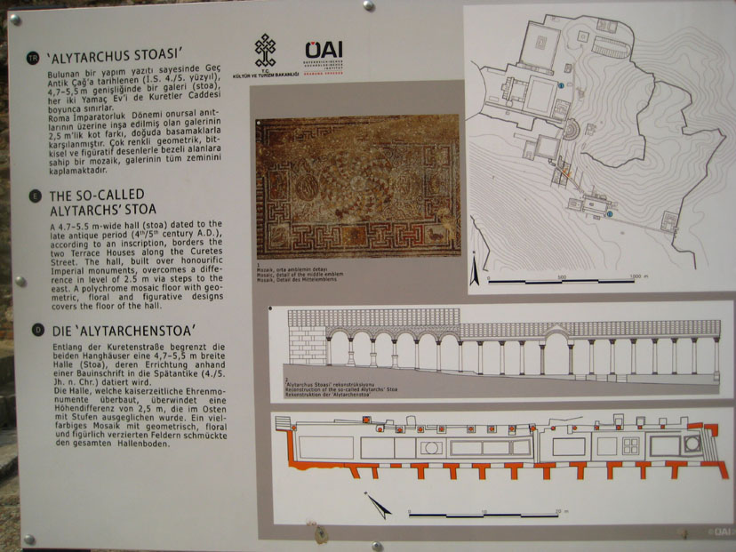
The Alytarch's Stoa
|
|
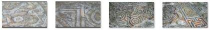
The floor of the long stoa was covered at its full length with a colorful mosaic covering an area of almost 2000 square feet. It was made of mostly geometric motifs, with the dominant colours being deep blue, white, red and yellow. Because of the difference in elevation in the stoa�s floor, the mosaic is arranged in two sections, the west and the east; in total it comprised twelve areas of varying sizes and decoration. Use the clickable thumbnails below to see these floor mosaics:
|
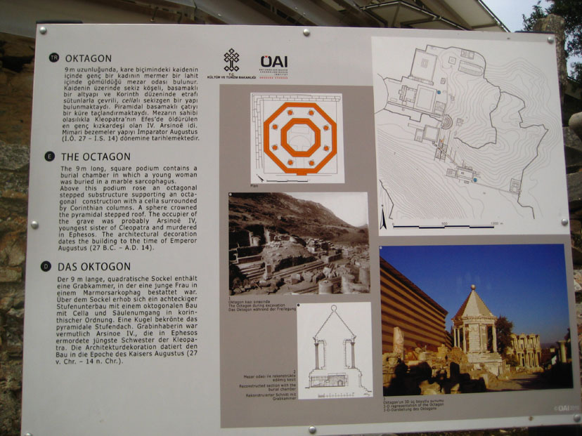
The Octagon
|
|
Arsinoe IV was the fourth daughter of Ptolemy XII Auletes, sister of Ptolemy XIII and Cleopatra VII. When Ptolemy XII died, he left Ptolemy XIII and Cleopatra as joint rulers of Egypt, but Ptolemy soon dethroned Cleopatra and forced her to flee Alexandria.
When Julius Caesar arrived in Alexandria in 48 B.C. and sided with Cleopatra's faction, Arsinoe escaped from the capital with her mentor Ganymedes and joined the Egyptian army under Achillas, assuming the title of pharaoh. When Achillas and Ganymedes clashed, Arsinoe had Achillas executed and placed Ganymedes in command of the army. Ganymedes initially enjoyed some success against the Romans, but the Romans soon received reinforcements and inflicted a decisive defeat on the Egyptians.
Arsinoe was transported to Rome, where she was forced to appear in Caesar's triumph. Despite usual traditions of prisoners in triumphs being strangled when the festivities were at an end, Caesar spared Arsinoe and granted her sanctuary at Ephesus. Arsinoe lived in the temple for many years, always keeping a watchful eye for her sister Cleopatra, who saw her as a threat to her power. Her fears proved well-founded; in 41 B.C., at Cleopatra's instigation, Mark Antony ordered her executed on the steps of the temple. She was given an honorable funeral and a modest tomb.
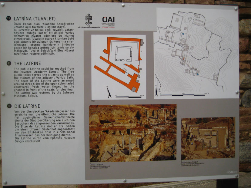
The Latrine
|
|
This large public bathroom was an adjunct to the Scholastica Baths; it was built in the first century A.D. Wealthy Ephesians had their own arrangements, but for the rest of the city a small entrance fee gained access to what was fairly modern indoor plumbing. The latrines had an uncovered pool in the middle, with toilets aligned along the walls. The columns surrounding the pool supported a wooden ceiling. Unlike vault toilets that you might see in state parks, or porta-potties you see at construction sites, the latrines incorporated a system for dealing with the waste. (This avoided the necessity of having to clean them out periodically.)
Underneath the toilets there was a stone vault to capture the waste matter. Periodically, water was diverted through this vault from an aqueduct, and the waste material was washed down the slope of the hill to settle and dry before it was removed to be used as fertilizer in the fields. I can only hope that some sort of odor-reducing agent had also been discovered and used.
No small effort was made to make this obvious human function a bit more pleasant. The latrines were decorated with mosaics depicting animals and flowers. The walls were decorated with geometric and floral designs, like those we saw here and here.
|
|
I might mention that just across Curetes Street from the Latrine entrance I saw a series of three inscribed stone tablets. These had been broken at some point and had been reassembled for us to look at. I was wondering what the writing said when a couple of tourists moved away and I saw they had been reading the translation on an information sign. You can read that sign here.
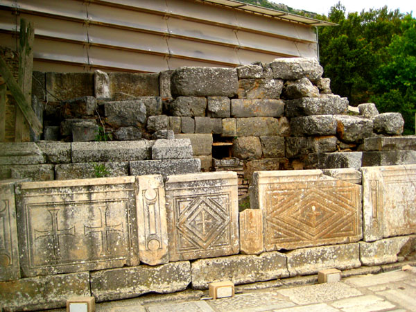
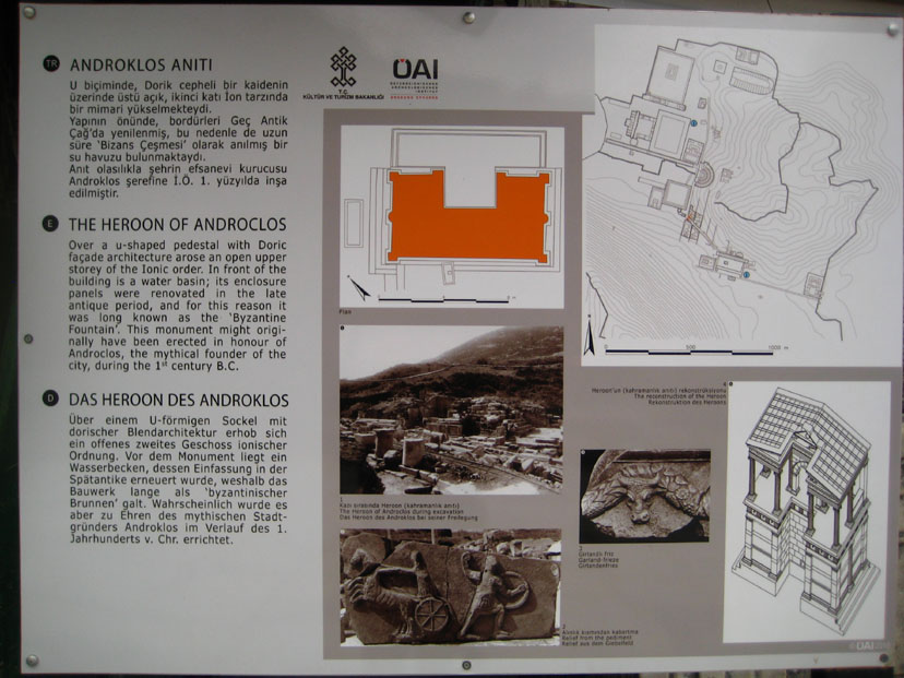
The Heroon
|
|
The Heroon was a second century B.C. U-shaped building with an open Ionic upper story. Water ran through a channel in front of the building. The gable and frieze had reliefs depicting Androclus killing a wild boar- the foundation story of Ephesus. The building is thought to have been a monument dedicated to Androclus.
Hadrian's Gate
|
|
The one in the center is wider and was spanned by an arch and the other two side entrances are capped by architraves- as you can see in this picture of the left‑hand entrance. The second story was formed of four pillars and the third story of six pillars. A gable marked the top of the building.
Below are clickable thumbnails for some additional pictures we took around Hadrian's Gate:
|
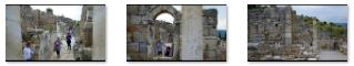
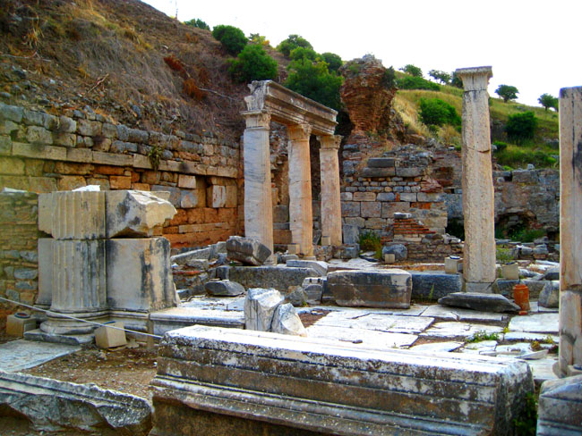
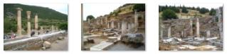
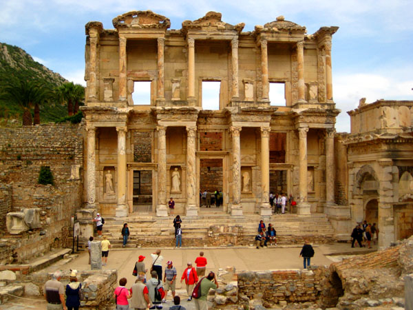
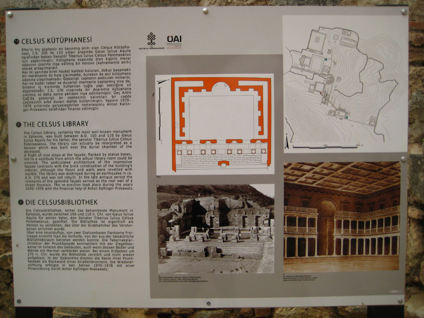
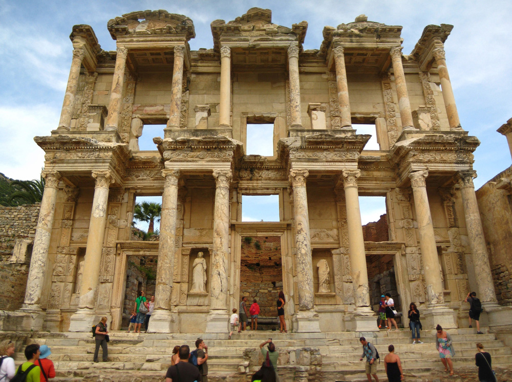
The Celsus Library
|
|
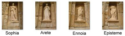
The Celsus library is one of the most beautiful structures in Ephesus. It was built in 117 A.D. as a monumental tomb for Gaius Julius Celsus Polemaeanus, the governor of the province of Asia; it was built by his son Galius Julius Aquila. The grave of Celsus was beneath the ground floor across from the entrance and there was a statue of Athena over it. Athena was chosen because she was the goddess of wisdom.
|
|
|
In addition to being the tomb of Celsus Polemaeanus, the building was, of course, also a library. The scrolls of the manuscripts were kept in cupboards in niches in the walls. There were double walls behind the bookcases to protect the them from the extremes of temperature and humidity. The capacity of the library was more than 12,000 scrolls. It was the third richest library in ancient times after the Alexandria and Pergamum.
The facade of the library has two-stories, with Corinthian style columns on the ground floor and three entrances to the building. There are three window openings in the upper story. They used an optical trick where the columns at the sides of the facade are shorter than those at the center, giving the illusion that the building is larger than it is. This same trick has been used many times since, the most familiar being at the Disney theme parks. It is the method that makes the buildings on Main Street USA look taller and larger than they actually are.
Of course, the exterior was richly carved, but it was tough to get close enough to get really good pictures. You can see the best one that we did get here.
|
|
|
The library was restored with the aid of the Austrian Archaeological Institute and the originals of the statues were taken to the Ephesus Museum in Vienna in 1910. The building also contained an auditorium, which was for lectures or presentations. It stood between the library and the Marble Road, and was built during the reign of the Emperor Hadrian.
The library and surrounding area were really spectacular, and so I took the opportunity to create a panorama of the entire area, encompassing Hadrian's Gate, the Celsus Library and the Gate of Mazeus and Mythridates. Use the scrollable window below to have a look at the result:
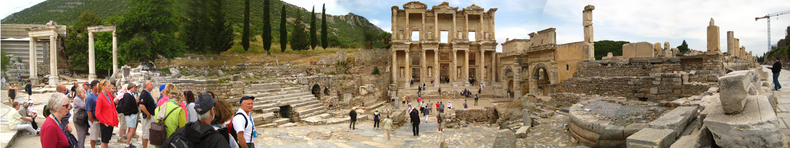
We also took a few more pictures around the front of the library, and you can use the clickable thumbnails below to have a look at them:
|
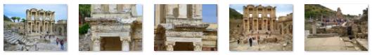
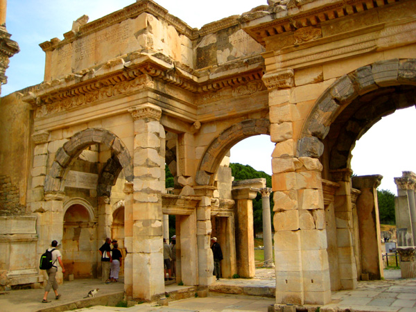
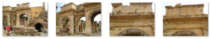
The Gate of Mazeus and Mythridates
|
|
The passages are vaulted, the front side of the vault facing the Celsus Library is made of black marble, while the other side is white. A Latin inscription with inlaid letters made of bronze is still visible on one side of the structure. Part of the inscription states: "From the Emperor Caesar Augustus, the son of the god, the greatest of the priests, who was consul twelve and tribune twenty times; and the wife of August Livia; the son of Lucus, Marc Agrippa who was consul three times, Emperor, and tribune six times; and the daughter of Julio Caesar Augustus, Mazeus and Mythridates to their master and the people."
Below are clickable thumbnails for some additional views of the inscriptions and the gates:
|
The small area in front of the gate was used as an auditorium. The steps around the gate, the front of the library and the round pedestal were used as seats. In the Byzantine Period, the walls in the small area were built when the city walls were reduced in length. After we left the area of the library and had walked down the Marble Road a ways, Fred got a picture looking back at the Agora side of the gates.
The Brothel
|
|
The construction of the building dates to the Emperor Trajan (98-117 A.D.) It has two entrances, one from the Marble Road and one from Curetes Street. It has a hall on the first floor, and on the second floor there are number of small rooms. On the west side of the house there is a reception area with colored mosaics on the floor, symbolizing the four season. The chamber next to it is the bath of the house with an elliptical pool. On the floor of the pool, there is a mosaic describing three women eating and drinking, a waitress standing, a mouse and a cat nibbling crumbs. Sadly, tourists cannot get in to see the floor of the pool.
I wanted to include one more picture of the brothel house here; it was actually taken earlier in the day when we were walking around the Scholastica Baths. It shows the Library of Celsus and the entire corner where the brothel house stood. You can have a look at that picture here.
The Marble Road
|
Along the Marble Road, archaeologists found some drawings on the stone walls that are believed to be advertisements for the "house of pleasure." Assuming that to be true, these drawings would appear to be history's first advertisements. The drawing is in the form of a "footprint," with one digit showing the location of the library and another showing the brothel. Beside the footprint is a woman's head, which apparently symbolizes the women waiting in the Brothel, and a heart, presumably indicating that the women are eager for love.
In a more serious vein, busts and statues of important people were erected along the road, and the letters from the emperors were carved into the marble blocks so that the people could read them. I guess the invention of the town crier was still a ways into the future.
Below are some clickable thumbnails for other pictures we took as we walked along the Marble Road from the Celsus Library to the Great Theatre:
|
The Commercial Agora
|
The original commercial agora took the form of a square, each side 340 feet, and surrounded by columns. The Agora had 3 gates, one from the front of the theatre on the northeast, the other one opening to the harbor on the west and the third one from the Celsius Library. The north side of the Agora was left open, and the other three sides were surrounded by a portico, in which there were rows of shops. At the center of the Agora was a sundial and a water-clock.
Over the years, the agora extended outside the square, and nearly doubled in size- ending as a long rectangle from the library to the theatre. Below are clickable thumbnails for some additional pictures of the commercial agora:
|
I also wanted to show you the entire agora all at once- including the additional area that was incorporated into it, so I constructed the panorama that is below:
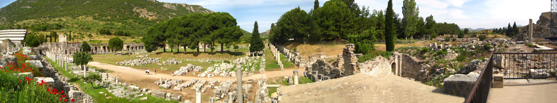
|
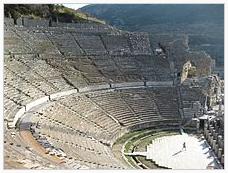
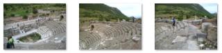
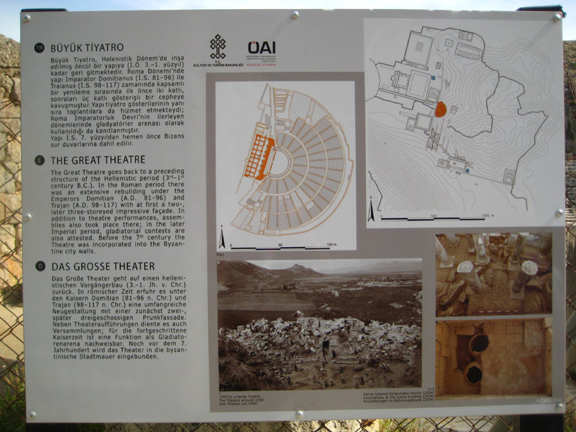
The Great Theatre
|
|
We came into the Great Theatre from the Marble Road along which we had been walking north. Since the theatre faces west, we actually entered at the southwest corner of the semicircular rows of seats. When we came up into the theatre itself, we were looking straight across the front of what had been the stage building. You can see the view that greeted us here. Right away we sat down to listen to our tour guide, and took some pictures of the theatre from this corner. There are clickable thumbnails below for some of these:
|
The Great Theatre at Ephesus is the largest such structure in Anatolia; it could hold 25,000 people. The amphitheatre has sixty six rows of seats, divided into three horizontal sections by two diazoma (walkways between seats). Going up in height from the stage there are three sections of seats. In the lower section, there are some marble pieces that have been used for restoration; the Emperor's box was located in the center of this lower section. The seats with backs made of marble were reserved for important people. The audience entered from the upper rows.
|
The Great Theatre |
Then, while she was talking, I walked up the rows of seats to the top row and then around to the center of that row, so that I was in the center of the theatre as high as I could get. Then I made a second movie looking around the theatre from this perch. You can watch it with the player below:
|
The View from the Cheap Seats |
The stage building was three-storied and 60 feet high. The facade facing the audience was ornamented with reliefs, columns with niches, windows and statues. There were five doors opening to the orchestra area, the middle one of which was wider than the rest. This enhanced the appearance of the stage, giving it a bigger, monumental look. This might be a good place to put some other pictures we took from various vantage points within the Great Theatre; use the clickable thumbnails below to have a look at them:
|
The theatre was used not only for concerts and plays, but also for religious, political and philosophical discussions and for gladiator and animal fights. One gathering that was held in the theatre is recounted in Paul's Letter to the Ephesians. When Paul was proselytizing, and encouraging Christianity, he was discouraging the worship of other gods. One Demetrius, a silversmith, made his living by making silver images of Artemis. Demetrius saw his livelihood threatened, and brought other such craftsmen together and warned them that their profession was going to fall into disrepute and their livelihood lost if Christianity prevailed. These men became angry and the city became filled with confusion.
|
The View from Center Stage |
With that story in mind, I wondered how the theatre would have looked to the city recorder, or indeed how it looked to anyone who was on stage to perform, or to speak or to fight. So I came down from the top row and made my way to center stage, turned and faced the seats and made my last movie of the Great Theatre of Ephesus. You can watch it with the player at right.
Before we leave the inside of the Great Theatre, I want to include two panoramas that I created from multiple separate photographs. The first one was created when I was sitting high up in the middle tier of seats, and you can see the entire theatre as well as the former port in the far background:
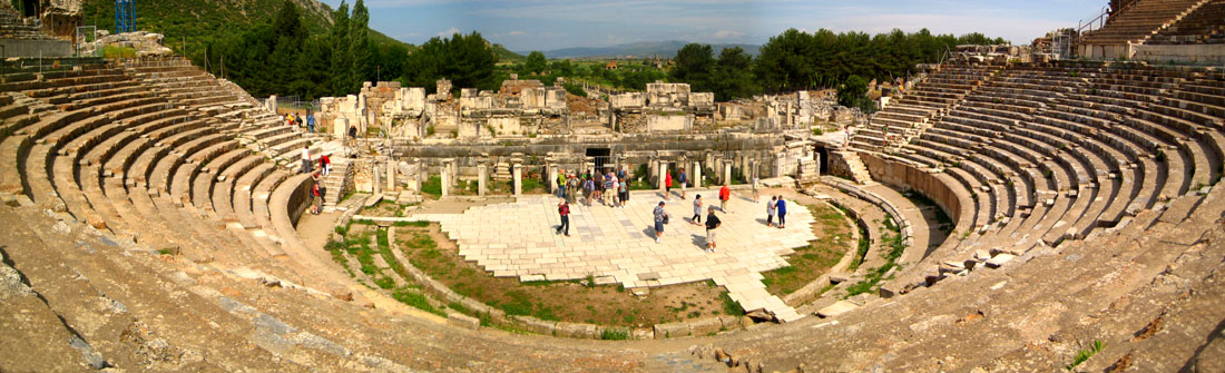
|
Lastly, I took a position on the stage and stitched together ten pictures for a 360-degree view. Use the scrollable window below to have a look at the result:

When our tour guide was done, she herded our group through the opposite exit at the north end of the stage.
|
The tunnel eventually brought us back out to the Marble Road. As we came out to the road again, we could see the stairs used by the public to enter and exit the north end of the theatre.
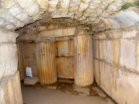
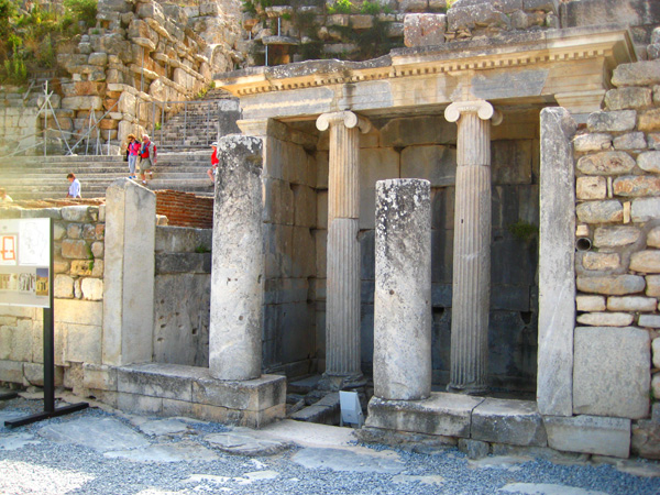
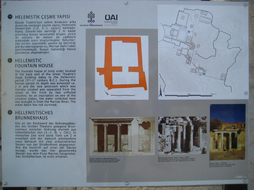
Fountain House
|
|
As an inscription on one of the columns states, the water collected here was brought in from the Marnas River. The water basin has not survived.
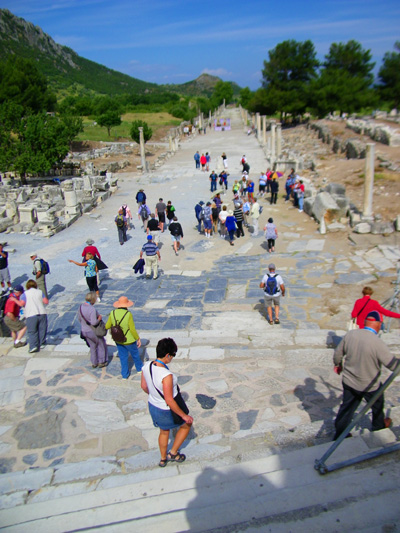
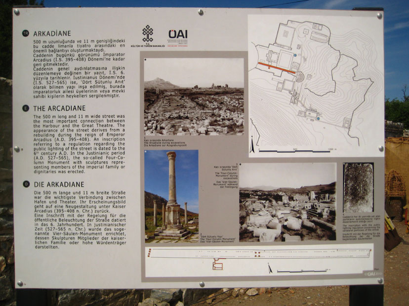
Arcadian Street
|
|
Before we headed down the steps of the Great Theatre to the street, I stopped to make a movie, and you can watch it with the player below:
|
|
The street was 1600 feet long and 35 feet wide, and on both sides of the street there were shops and galleries, and gates in the form of monumental arches. There were four higher columns with the statues of four apostles on the top. In the entire Roman Empire at the time, there were only three lighted streets- one in Rome, one in Antioch and the Arcadian Street. Street lights (torches) lit up its colonnades. Water and sewerage channels ran beneath the marble flagstones. Below are clickable thumbnails for some of our pictures of this amazing thoroughfare so you can have a look at it:
|
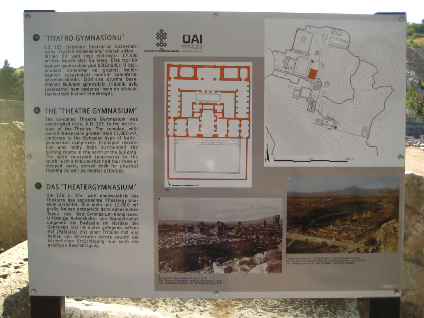
Going from the Great Theatre towards the harbor, one first passes the ruins of the Theatre Gymnasium.
|
|
As you might have noticed from the pictures of Harbor Street above, tourists were only allowed to walk about halfway down to the street to where the harbor used to be. (Remember that the silting process of the river that used to flow by Ephesus eventually moved the harbor miles away, and that there is no water here anymore. But if the harbor were today where it was then, you would have seen wharves and ships at the end of the street.)
|
Another interesting aspect we learned about were the milestones, some of which were on display along the street. Like today, they were laid on the roadsides to mark distances between cities. Mostly they were local stone, but some were marble. One, in the Ephesus Museum, demonstrates that the measurements were in "stadia" (600 feet). Beside showing the distance, they were usually inscribed with the name of the Emperor who had the road built or who maintained it. In an unusual move, the carved letters were also painted in red to increase visibility. Sometimes, the Emperor's name that was carved was just the current one, who may have done nothing to build or maintain the road; these were usually placed in highly visible locations like important crossroads. Continually changing them as the Emperors changed was a pain, though, and to save stones and carving time, they were often reused by being turned upside down so the other side could be carved anew.
Our walk partway down Arcadian Street brought our tour of Ephesus to a close, and we started up the tree-lined walkway to the north exit where our buses waited. Turning and looking back, I caught one last view of the Great Theatre.
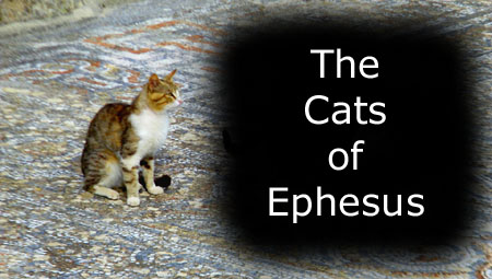
Postscript: The Cats of Ephesus
|
To view the slideshow, just click on the image at left and I will open the slideshow in a new window. In the slideshow, you can use the little arrows in the lower corners of each image to move from one to the next, and the index numbers in the upper left of each image will tell you where you are in the series. When you are finished looking at the pictures, just close the popup window.
Returning to the Port and the Noordam
|
|
The trip back to the ship on the bus was short but pleasant, and our guide kept up a running commentary while we took pictures out the windows. We took quite a few, but I've put clickable thumbnails for only a selection of them below:
|
|
As our bus came back into Kusadasi, we passed a couple of sites that we wanted to visit after we'd had a snack back on board the Noordam. One was Pigeon Island, where there is an old fortress, and Ataturk Monument, a huge statue of Turkey's revolutionary hero and first President.
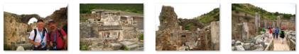
The bus let us off back at the dock, and Fred got a picture of Greg and I before the three of us went back on board.
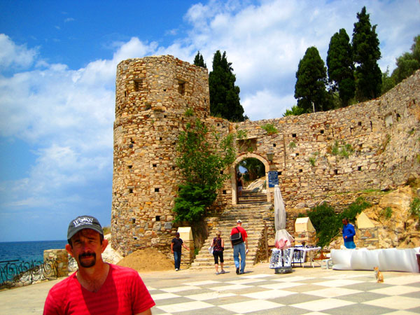
A Visit to Pigeon Island
|
Just west of the main cruise ship dock, we walked through a small seaside park. It had water features, fountains and sculpture, and seemed to be the kind of place where people might come to have lunch or just sit in the sun. It was quite small, but quite well done. Below are clickable thumbnails for some pictures of Guvercinli Park:
|
From the park, we continued walking west along the shore road. The sea was to our right, and the city to our left, with the businesses and homes terraced up the hillside- with stairs going up every so often. We passed a city clock tower and the Victoria Restaurant. The restaurant had homes extending up the hillside behind it, almost to the Ataturk monument. You can see a good view of how all this looked here. Along the way there were a lot of nice views looking ahead to Pigeon Island and back to the ships at the pier; I have put clickable thumbnails for some of these views below:
|
When we got to the breakwater that connects Pigeon Island to the mainland, there were great views looking back towards all the cruise ships docked in the harbor at Kusadasi.
|
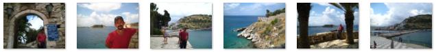
I walked back around the walkway to meet up with Fred again, and this time we walked a bit southwest towards the entrance the fortifications. We were still right at the shoreline of the island (which has beautiful clear water- reminiscent of Hawaii or someplace similar), so Fred had me stop so he could get a couple of pictures- one looking back at the causeway and Kusadasi and another looking southwest along the shoreline of Turkey towards another island along the coast.
|
Before and during Ottoman times, the island was used for securing the shores and for preventing attacks from the sea. Today, the island is the ideal place to get a panoramic view of the city and to witness one of the world's best sunsets (which, sadly, we could not stay to see). The island also has a couple of cafes, one built in the fortification itself; with local drinks and the beautiful scenery they are very much frequented by locals.
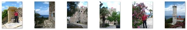
We, however, are here to walk around the old fortifications and observe some of the ruins that go back to long before the Ottomans gained control of the area.
The island was a pretty neat place- so close to the city and with so much history. We enjoyed just going up and down the walks and stairs, walking around the fortifications and admiring the views. Let me just put clickable thumbnails below for some of the best of the pictures we took so you can tour the island with us:
|
|
I also took the opportunity to make a panoramic harbor view from the top of the hill on Pigeon Island, and the result is below:
 |
As we were leaving Pigeon Island back along the causeway, Fred happened to see three orange tabby cats, and he immortalized them in a picture.
Ataturk Hill and Monument
|
As we ascended, we snapped pictures looking back and the island and harbor, and I have put clickable thumbnails below for four of these pictures. The first two were taken just as we started out and the second two as we approached the fence:
|
When we got around the fence, we found ourselves on a park road that led back down to the monument; you can see that road coming into the plaza in front of the monument here. This brought us to the rear of the Ataturk Monument.
One of the first things I attempted when we got to the observation just below and at the back of the monument was to take a series of ten pictures that I hoped to stitch together into a panoramic view from the top of the hill. I didn't keep the camera quite level as I snapped the pictures, but the end result wasn't too bad. Use the scrollable window below to have a look:
Walking around on the observation platform behind the monument we were able to get amazing views of Kusadasi- from Pigeon Island around to the eastern part of the city.
|
|
|
We also took some movies up here, but aside from one of them, I didn't think they added much to the still picture views that we got (especially in light of the panorama above).
|
|
Both Fred and I made movies during prayer call, but I think his is better, as he zooms in (a bit too quickly, sometimes) on three of the minarets that we could see in the city below. You can watch that movie with the player at right. And I have put clickable thumbnails below for three close-up pictures Fred took of these mosques and minarets:
|
We spent a bit more time up here admiring the view. The observation area is actually at the back of Ataturk's statue, but I wanted to get a picture of the front view. There was a walkway that led to a grassy ledge down below the front of the statue, so I followed it to get the picture that you can see here.
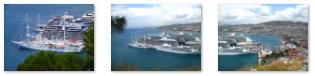
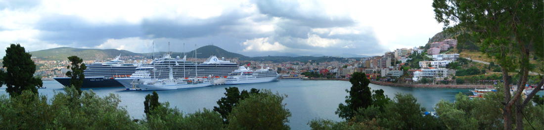
One final thing before we leave: while we'd gotten the cruise ships in a number of photos, I didn't have a good one concentrating just on them. So I used my own zoom to take a set of three pictures of them, and merged them together to produce the photo below:
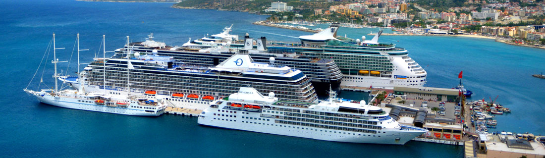 Cruise Ships Docked in the Harbor at Kusadasi |
We were all done up here on the hill, so this time we followed the park road back to the entrance to find our way back down to the road along the shore.
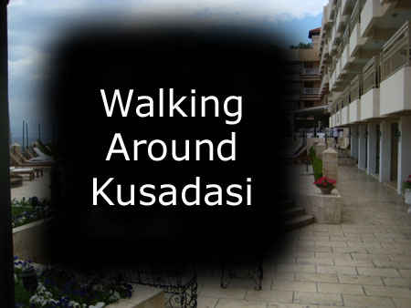
Walking Through Kusadasi
|
To view the slideshow, just click on the image at left and I will open the slideshow in a new window. In the slideshow, you can use the little arrows in the lower corners of each image to move from one to the next, and the index numbers in the upper left of each image will tell you where you are in the series. When you are finished looking at the pictures, just close the popup window.
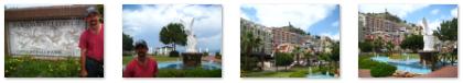
We came out by a hotel that looked like a castle. I never did find out whether it was actually built in an old castle building, or just built to look like one, but it was interesting looking so we went over to the "moat entrance" to have a look inside. In the center of the structure was a large open‑air atrium, containing a cafe and bordered by shops and hotel facilities. There were some interesting sculptures, and from the second floor balconies hung a riot of colorful bougainvillea vines. It seemed like a nice place to stay, but of course we didn't see any of the rooms.
We left the hotel by the front entrance, crossed the plaza in front, and headed back over to the cruise ship dock, passing a local marina on the way.
Leaving Kusadasi
|
Back on board, Fred and I went up on deck for a while to enjoy the afternoon. Here, I stopped to make a couple of short movies showing two of the ships docked next to us on either side. If you would like to see these movies, just use the players below:
|
Oceania's "Silver Sea" |
A Norwegian Cruise Lines Ship |
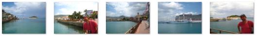
We also hung out on the aft deck closest to the harbor to get some pictures.
|
There are clickable thumbnails at left for a few of the pictures we took this afternoon from the rear of our ship. One that I particularly liked was a picture of the Kusadasi harbor where you can see the Turkish flag flying. After a while up on deck, we went back to the cabin to get ready to hit the gym. Relaxing out on the balcony with a copy of "Atlas Shrugged" (which I am re-reading since Fred has brought it along) and a small Bailey's, I got a nice view looking back along the side of the Noordam towards the port of Kusadasi, and you can see that view here.
|
|
I also took a couple of pictures. One was of the large, four‑masted schooner that had been docked on the other side of the Silver Sea and which was now also heading out. And I got one more picture looking back at the harbor of Kusadasi.
We did our normal evening routines with the gym and, I think, dinner up in the Lido Buffet. We also dropped in to the show in the Vista Lounge, which was a magician- Stephen Garcia.
No towel animal of note this evening.
You can use the links below to continue to another photo album page.
|
May 25, 2012: Santorini, Greece |
|
May 23, 2012: Athens, Greece |
|
Return to the Index for Our Mediterranean Cruise |