|
May 26 - June 1, 2013: Our Trip to South Dakota |
|
April 13, 2013: Dallas Opera at Cowboy Stadium |
|
Return to the Index for 2013 |
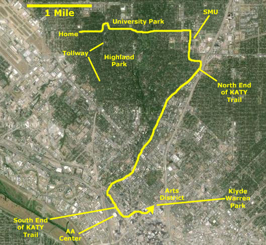
For the last four years, there has been a major construction project going on downtown, near the Myerson Symphony Center and the Nasher Sculpture Center. About four blocks of the Woodall Rogers Freeway downtown has been covered over (making a tunnel for the freeway underneath) and a new park built on top. We wanted to go see this new park this afternoon, and wanted to ride our bikes downtown to do it. The route downtown is via the Katy Trail. While we ride on the Katy Trail frequently, we have not been down to this new park, and so today I've taken my little camera along with us.
The KATY Trail
|
|
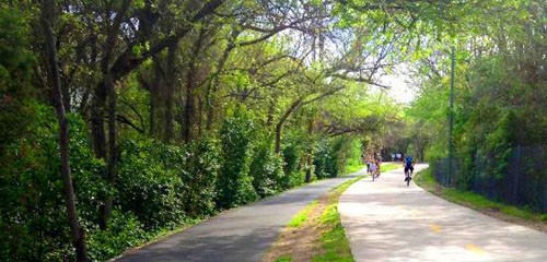
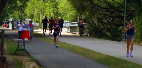
Although we have been on the trail with our bikes frequently, I have never taken my camera and tried to take pictures as we ride; the trail is usually crowded and that might be dangerous. One day, I might do a page with a bunch of photographs, but for now, the two images at the far left, taken from the Katy Trail website, will have to do.
Getting to Klyde Warren Park
|
McFarlin, a residential street, heads east through Highland Park, crosses Preston Road and continues east across Turtle Creek. It passes the back of the golf course at the Dallas Country Club, and then heads up a long hill as a divided residential street through the neighborhood occupied mostly by people who work at or attend SMU. McFarlin dead ends into Hillcrest Avenue.
At Hillcrest, we cross over and are now on the SMU campus. We go a short distance through a parking lot and then come out at the fountain in the center of the campus. From there, we go south on the tree-lined main campus avenue which takes us all the way south to Mockingbird Lane. We cross Mockingbird and then jog south, east and south again to arrive at the point where the current north end of the Katy Trail crosses Airline.
Now we are on the Katy Trail, and we take it 3.5 miles south all the way to the American Airlines Center. We only have to cross one street- Knox Street- but the crossing is well marked and lighted and cars have to stop for the pedestrians, bikers, joggers and skaters. All the other streets have bridges over them.
From the AA Center, we do have to ride on city streets, but these are only busy in the middle of the day on workdays, so at the times we ride, they are virtually empty. We just zig-zag northeast to cross over Woodall Rogers at Akard, just one block south of the south end of Klyde Warren Park. The return trip is just the reverse of the trip down. To the park and back is about a 15-mile round trip, and it is a very, very enjoyable ride.
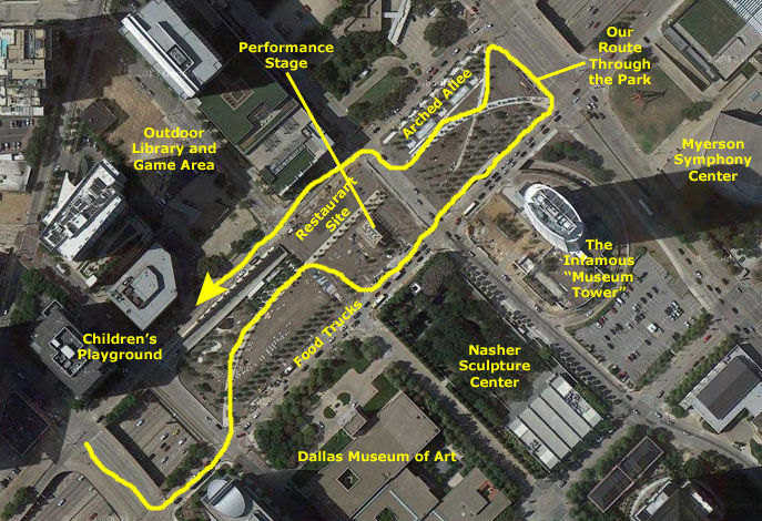
Klyde Warren Park
About Klyde Warren Park
|
The park deck is a feat of engineering and design. It had to be at street level yet preserve clearance for the highway below. An ingenious arrangement of more than 300 concrete beams and a large number of support members have created a solid deck for the park. They also created a series of gigantic "planter boxes," suspended over the freeway, that are large enough that small trees can be planted in them.
A landscape designer created different �rooms� throughout the 5-acre park. The sustainable landscaping includes 37 native plant species and 322 trees, hiding an active freeway with a beautiful urban oasis. There are open lawns, rows of trees, a children's playground, a performance stage, an outdoor library, water features and areas for a restaurant and for a series of upscale food trucks that provide service all day long.
At Klyde Warren Park
Along both long sides of the park, there are double rows of trees, or allees, and these have a series of arches spaced along them. The arches support lighting globes. From the southeast corner of the park, we could look north through one of these allees, and you can see Fred and the allee here.
|
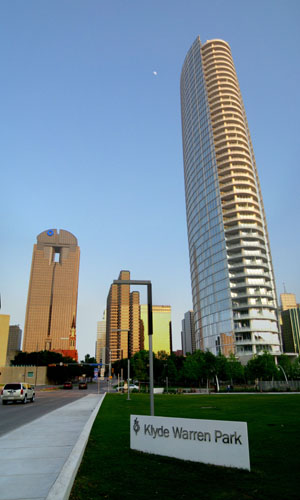
While he was doing that, I was looking around at the Dallas skyline. I had an excellent view of Museum Tower, the tall, elliptical, residential building that is causing so much controversy. (Apparently, no one tested the building's exterior skin enough to discover that most times of day, anyone looking in the building's direction would be blinded by the glare- and that at certain times of day, this glare focuses on the Nasher Sculpture Center. People in the sculpture garden have to wear sunglasses, and the light shining through the museum's glass skylights is actually damaging the artwork on display inside. The building, probably due to this controversy and the cost of the units, has only two residents so far.)
I got some other nice views of the west side of the Dallas downtown core, and you can use the clickable thumbnails below to see some of these:
 |
Here at the outdoor library is a great place to see most of the park, and there are great views of downtown as well.
|
|
We continued walking our bikes to the northern end of the park where the freeway comes out of the tunnel and ascends to the interchange between US 75 (Central Expressway) north and I-45 south to Houston. You can see a view looking north here.
|
From the northwest corner of the park, there are good views of the southern part of the downtown core if you look back over the park, and we are at the end of the second allee in the park- the one that runs along the north side. It, too, has arches and lighting globes and extends all along the side of the park. (It will be interrupted by a new restaurant which is going to be built partially over the freeway below; it is supposed to open in late 2013.) Anyway, I have put clickable thumbnails below so you can see a few of the pictures we took from here:
|
|
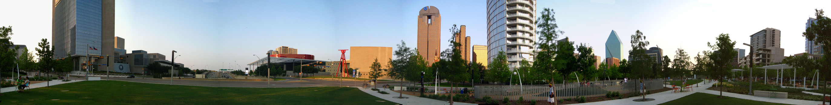
I'm going to finish up the pictures for this afternoon by including two panoramic views that I constructed out of multiple photographs. The first one centers on the base of Museum Tower, and captures the Meyerson on the left (with its distinctive lawn sculpture) and the south end of the park on the right; it is below:
 |
The second panorama is much larger in scope. It is, essentially, a 360° look around from the northwest corner of the park. At the extreme left, it begins at Pearl Street to the left of the Dallas Federal Reserve building and then pans all the way around past downtown and the entire park to come back almost to its starting point with the buildings along the northwest side of the freeway. My aim wasn't perfect, but it turned out well, and you can use the scrollable window below to have a look at it:
You can use the links below to continue to another photo album page.
|
May 26 - June 1, 2013: Our Trip to South Dakota |
|
April 13, 2013: Dallas Opera at Cowboy Stadium |
|
Return to the Index for 2013 |