|
July 16, 1971: Volcanoes National Park |
|
July 14, 1971: The Punchbowl and the Arizona Memorial |
|
Return to the Index for My Visit to Hawaii |
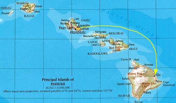
Today I am going to fly over to the island of Hawaii (usually referred to as "The Big Island" so as not to confuse the name of the island with the name of the entire state) to spend one night there and see as much as I could.
Getting to the Big Island (Hawaii)
|
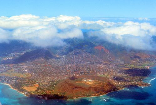
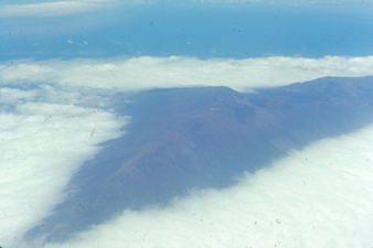
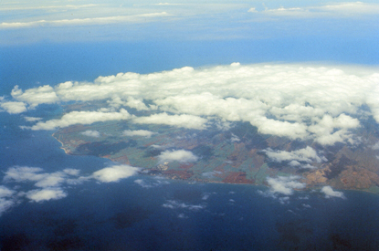
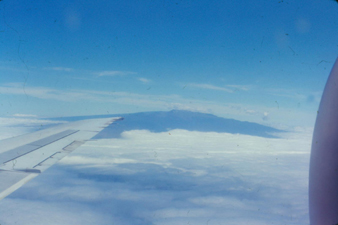
So now I am on my third or fourth commercial flight over to Hilo. I say all this to let you know that I am still a novice flyer and, as such, I find flying fascinating and always want to sit by the window- as I did on this flight.
The actual flight over to the Big Island only took an hour, and most of that was getting up and coming down. I was on a small plane that only had about sixty people or so (the plane had propellors; it was not a new jet aircraft).
One of the points about sitting at the window is so I can take pictures, and I got quite a few good ones as we flew over to Hilo.
|
|
|
|
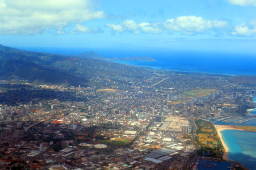
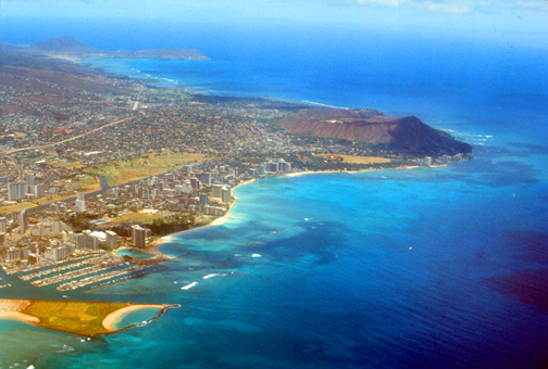
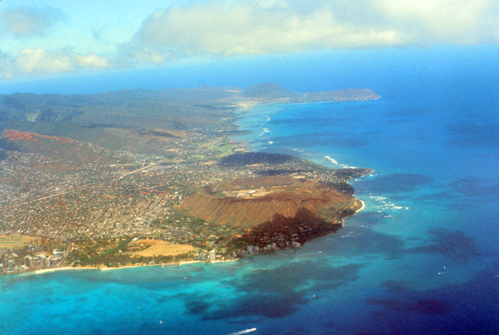
Towards the end of the flight I got a few decent pictures of the Big Island itself, and these are below:
|
|
|
The landing was a good one, and when they rolled the stairway up I took my small suitcase and headed into the terminal (I left most of my stuff at Fort DeRussy). Inside the terminal, I went to the rent-a-car counter to pick up the small car that I'd reserved. I had just a bit of a problem in getting them to rent the car to someone so young who didn't have a credit card, but a copy of my orders back to Fort Harrison, my military ID, and a deposit check got me the car. I also stopped at the tourist counter to inquire after motels around Hilo and I got a couple of recommendations.
The main thing I wanted to see here was Volcanoes National Park, but since it was already approaching lunchtime, I thought I would save that excursion for tomorrow, and so I set off in my small car heading north- the opposite direction.
Leaving Hilo
|
I had given some thought to making a drive all the way around Hawaii (after first checking that, unlike on Oahu, the road actually goes all the way around). But then I thought that this might take too much time, and not allow me to get out of the car much to actually go see things.
I checked my map, and it appeared that the north shore was the most scenic, and I saw that there were numerous waterfalls and black sand beaches on this side of the island, and also much shore scenery to view. The other side of the island is more commercial and resort-oriented, and of course I will see the area south of Hilo tomorrow when I visit Volcanoes National Park. The map also noted that Akaka Falls was nearby and that there was a hike you could take to actually get to it.
So I decided that this afternoon I would just take a leisurely drive up at least as far as Honokaa (where the road turns inland and heads across the island to the west coast) and stop at whatever looked interesting.
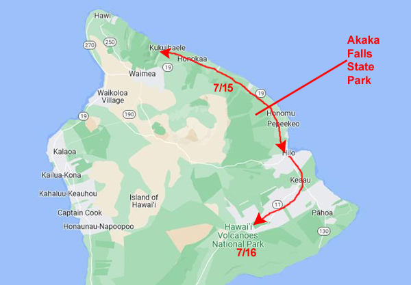
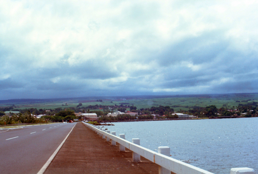
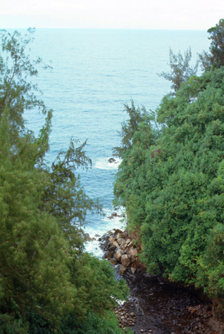
So I headed north on state highway 19 that leads all the way up to Waimea near the northern tip of the island. I first crossed the bridge at the mouth of the Wailuku River, and then about a mile further up the coast stopped to look back at Hilo.
|
|
The one thing that you will notice right away is that in contrast to the generally sunny weather on Oahu, the weather on the Big Island is much less so. In fact, the weather on the east side of Hawaii, where Hilo is, has the least sun of almost anywhere else in the state. Even on the west side of Hawaii, the weather is generally better.
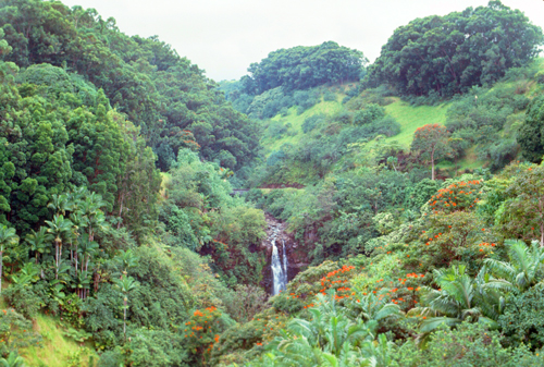
Akaka Falls
Akaka Falls State Park |
|
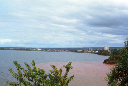
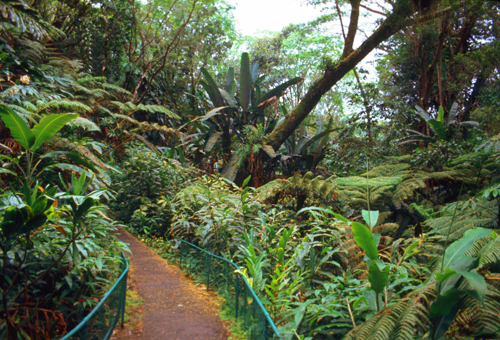
I parked and began to follow the paved trail to get out to the falls themselves. Just a short distance down the trail, I encountered one of the many small streams that ran alongside the trail, and just a few hundred feet further on I passed a very small waterfall on another of the many streams in the area.
Local folklore describes a stone here called Pōhaku a Pele that, when struck by a branch of lehua āpane, will call the sky to darken and rain to fall. Lehua āpane or ōhiʻa āpane is an ōhi'a tree (Metrosideros polymorpha) with dark red blossoms.
|
|
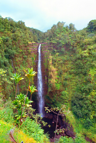
My best picture of the falls came from the marked observation point on the circular trail, and a spectacular view it was. This waterfall is the highest single cascade in Hawaii; there are taller falls, but they drop in steps to their bottoms.
Leaving the overlook, I continued on the circular path back to the parking area, going by a couple of very small streams and at least one waterfall that I could hear but not see. For the most part, it was an easy walk up the trail and there were lots of interesting things to see.
As I drove back towards the main highway, I stopped in the small town of Honomu. The stores on Main Street looked really interesting. I stopped and had a soda at one of them, and spent some time in an intriguing antique store before going back to the main highway to continue up the coast.
Hawaii's North Coast
|
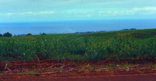
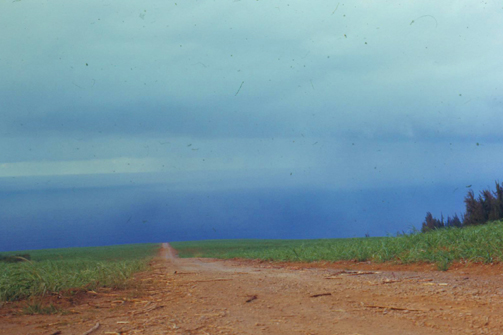
Sugar cane production on Hawaii is greater, as a large part of the island is more gently sloping than, say, Oahu.
I found myself now in the district of Hāmākua on the Big Island's northeast coast. The name of the district is also the name given for the general coastline in this area- the "Hāmākua Coast".
|
|
This part of the driver was very, very scenic and, again, much like what I would suppose the Pacific Northwest Coast on the US mainland is like.
Hāmākua's coast is approximately 50 miles long, along the Pacific Ocean ending at Waipi'o Valley and the uninhabited Waimanu Valley. The term Hāmākua Coast is used loosely to describe the region between Hilo and Waipi'o. The rainfall due to the prevailing northeasterly tropical trade winds produces steep erosional valleys and cliffs, showing evidence of frequent landslides. The lush vegetation and lack of sandy beaches contrasts sharply with other regions of the island.
The dominating geographic feature in Hāmākua is the dormant volcanic mountain Mauna Kea. The district stretches south through the central plateau to the summit of Mauna Loa which is, of course, active, and the location of Volcanoes National Park.
|
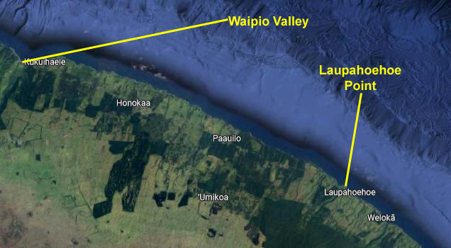
I am coming up from the southeast along the coastal highway, which I have not bothered to draw in on the view. It comes up from Hilo to the area near Honokaa before turning westward and heading inland to cross the island to Waimea. My tourist guide suggested two places to stop and view the scenery, both of which were just off the highway.
One was Laupahoehoe Point, a particularly scenic, very rocky, volcanic coastline, with a road that has been built down to it. It is part of a park, and is supposedly not to be missed. The other major site was the Waipio Valley, which was described as one of the Big Island's premier attractions with its deep valley, flowing stream, and black sand beach.
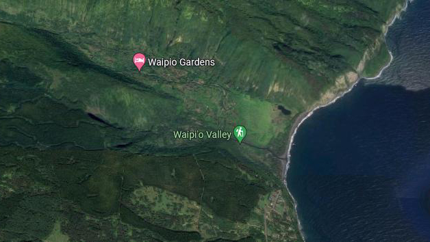
This second attraction was located north of Honokaa, and there were directions to get to it. It is one of the most northern, vehicle-accessible points on the northeast coast of the island, right at the top of the Hamakua District.
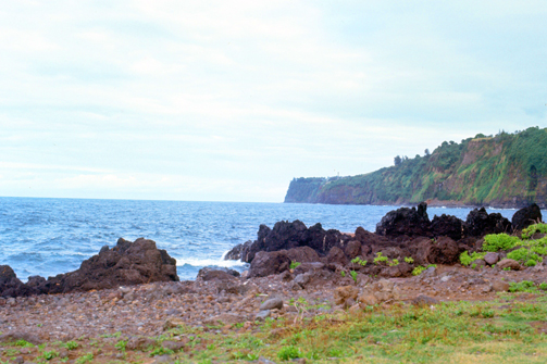
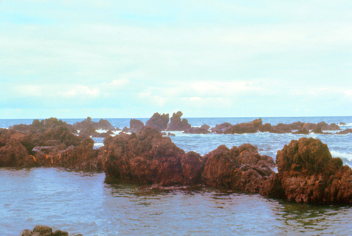
I plan to stop at both places, and I did. So let's take the first one that I came to- Laupahoehoe Point. Laupahoehoe is a community north of Hilo, and the name of the town means "lava tip" and refers to an angular lava tip or cape formed by ancient pāhoehoe (smooth lava) flows which created the cape on which the community was built. Near the community is Laupahoehoe Beach Park with some of the neatest lava scenery on the island:
|
|
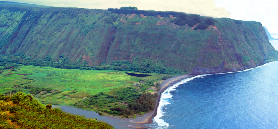
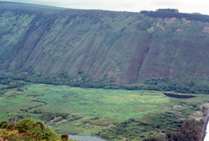
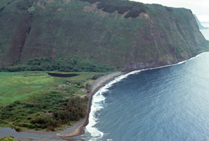
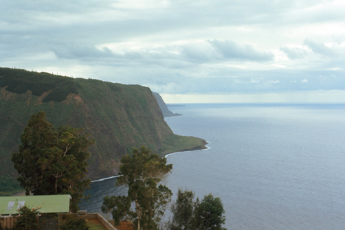
The other stop I made (indeed, the last stop I made) was at one of the most spectacular vistas from my entire trip to the Hawaiian Islands- it was the view at the Waipaio Valley north of Honokaa. Waipio Valley is not a familiar mountain valley, and indeed I think it can only be described with pictures. To introduce them, you should know that in Hawaiian, Waipio means "curved water". I had seen this sight mentioned in my tourist brochure, and I found the road to the overlook for the valley without too much trouble.
|
A steep road led down into the valley from the small parking area and lookout point located on the top of the southern wall of the valley. At one point the road descends 800 feet in half a mile at a 25% average grade, with steeper grades in shorter sections. This is a paved public road but it is open only to vehicles equipped for such steep grades. It is the steepest road of its length in the United States.
The shore line in the valley is a black sand beach, popular with surfers. A few taro farms are located in the valley. Several large waterfalls fall into the valley to feed the river which flows from the foot of the largest falls at the back of the valley out to the ocean. There are numerous hiking trails in the area, and if the weather hadn't been so threatening, I probably would have gone off on one of them.
|
|
|
Also just for fun, and obviously not something I could have done in 1971, I want to show you some movies of the Waipio Valley. "Movies?" you say? You didn't tell us you had a movie camera with you! Well, in fact I didn't. So what's the deal?
|
|
Since I created the pages for the years prior to 2000 in the years after 2005, I have had the wealth of information provided by the Internet available to me. That's why you see maps and aerial views on pages showing pictures taken long before those resources were available. Sometimes, this allows me some anachronistic fun, and this page is one of those times.
In 1995, an American actor who was turning 16 at the time I was standing on the Waipio Valley overlook would make a movie called "Waterworld". In researching this page, I learned that the final scenes of this movie were actually filmed here in and above Waipio Valley. So I obtained a copy of the movie, cut out the clips that actually show Waipio Valley, and glued them back together into something of a montage featuring the Valley itself. That movie is at left, and if you just click on the image, you can see Waipio Valley as it was featured in the movie. Enjoy!
I took a couple more pictures from here as well.
|
|
I really enjoyed my drive up the coast of Hawaii, although the overcast, threatening skies detracted somewhat from the beauty of my surroundings. I could have wished the day had been clearer, and as I drove back down south to Hilo to get a motel room for the night, I was hoping that the weather would be better tomorrow for my visit to Volcanoes National Park.
You can use the links below to continue to another photo album page.
|
July 16, 1971: Volcanoes National Park |
|
July 14, 1971: The Punchbowl and the Arizona Memorial |
|
Return to the Index for My Visit to Hawaii |