|
July 13, 1992: Bandelier NM and the Jemez Mountains |
|
July 11, 1992: Walking Around Santa Fe |
|
Return to the Index for the Santa Fe Trip |
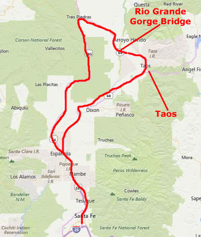
Today, the three of us are planning an excursion up north from Santa Fe to the pueblo of Taos. We'll explore there for a while, and then drive out to the Rio Grande Gorge and its famous bridge.
|
After that, we'll continue northwest on US Highway 64, crossing the Rio Grande at Rio Grande Gorge and the eponymous bridge. Rather than backtrack, we'll make a big circle up through Tres Piedras and then back south on US Highway 285 again to Espanola.
It will be a full day, so let's get started.
Santa Fe to Taos
|
|
When we got to the town of Taos, we drove right on through to the Taos pueblo.
The Taos Pueblo
|
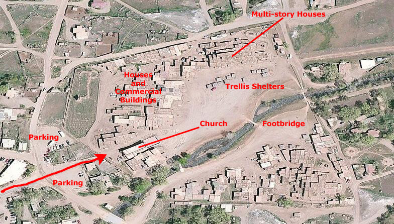
I have labeled some of the features that you'll see in our pictures. One of the most photographed buildings is the Pueblo Church; almost all the residents of the pueblo and the nearby areas are Roman Catholic (although a great many of these people go to the Catholic Church in Taos city. The church in the pueblo is used for special events, although there are actually Masses said there a few times each week.
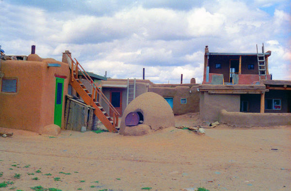
The part of the pueblo north of the Rio de Pueblo Taos (the Pueblo Taos River) has been widely painted and photographed, although the buildings south of that river are also interesting. Many of the pueblo buildings were two and three stories high; in most cases, the second and third floors were reached either by wooden ladders or outside stairs.
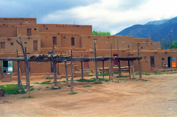
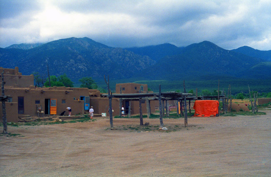
You will see many of these features in the pictures that we took here this morning. You will also see that in the northern part of the large open area in the center of the pueblo that there was a series of arbor-like structures that were used for outside gatherings, meals, and other functions. They provided an element of shelter from the sun.
|
Right away, we saw an excellent example of many of these construction methods can be seen in the very first picture we took here. This view, shown at left and taken looking north from the pueblo's open central area, shows the arbor structures and the multi-storey buildings north of them. I thought that one oddity were the two colorful doors; which, of course, were not "original equipment" to the adobe construction of the pueblo.
The pueblo turned out to be a curious mixture of "authentic pueblo" and "tourist trap". There are, it turns out, still Puebloan Indian descendants living in the pueblo, and we saw some evidence of that, but I found it hard to believe that to be the case as everything that was going on was apparently for the benefit of the tourist. I saw little evidence of day-to-day life being conducted.
This part of the Pueblo is said to be one of the most photographed and painted buildings in North America. It is the largest multistoried Pueblo structure still existing. It is made of adobe walls that are often several feet thick. Its primary purpose was for defense. Up to as late as 1900, access to the rooms on lower floors was by ladders on the outside to the roof, and then down an inside ladder. In case of an attack, outside ladders could easily be pulled up.
Most of the buildings were empty, and as you can see here there are none of the items that you might expect to see if these building were being occupied day in and day out. This may have been the way the Indians dwelt in the past, but I think that those days are gone. Nevertheless, the pueblo was interesting as a restoration of what it must have been like in its time. You can see that the buildings are multi-story, and there are ladders to get to the upper stories. I don't think that there are any inside stairs.
 At the Taos Pueblo Those are the Sangre de Cristo Mountains in the Distance |
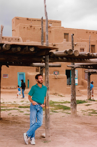
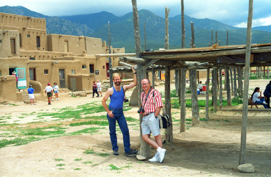 Fred and Greg at the Taos Pueblo The trellis affair was used for a number of purposes- to provide shade for outdoor activities, for drying things and for keeping things out of the way of animals that might get at them on the ground. |
|
|
In a couple of these rooms there were craft items for sale, but I never saw anyone actually making them here. I got the impression that the tribe that owns the pueblo just uses it as a way of generating income; while the tribe doesn't actually live here, they maintain it as if they did.
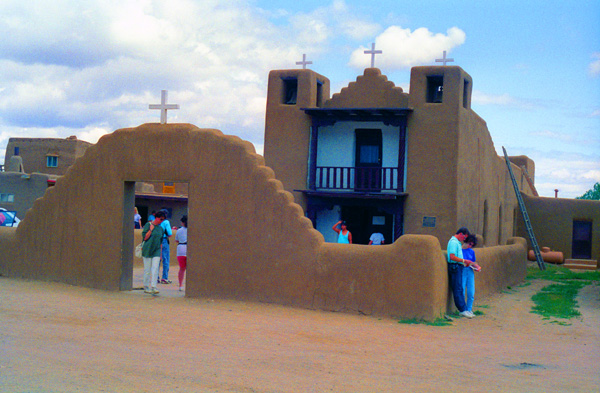
Two spiritual practices are represented here in the Pueblo: the original indigenous spiritual and religious tradition and Roman Catholicism. The majority of Taos Indians practice their still-vital, ancient indigenous religion. Most (90%) members of the Taos Pueblo community are baptized as Roman Catholics. Saint Jerome, or San Geronimo, is the patron saint of the pueblo, and the next place we stopped was the pueblo church.
|
The first Spanish visitors to Taos Pueblo arrived in 1540- members of Coronado's expedition searching for the rumored Seven Cities of Gold. Around 1620, Spanish Jesuits oversaw construction of the first Catholic Church in the pueblo, the mission of San Geronimo de Taos. Native peoples resisted both the church and Catholicism, and throughout the 1600s, tensions between native populations and the Spanish grew. Sometime around 1660, the native Taos people killed the resident priest and destroyed the church. It was rebuilt, but destroyed again during the Pueblo Revolt of 1680 when two more resident priests were also slain.
By 1700, San Geronimo de Taos was under construction for a third time. Spanish/Taos relations were amicable for a brief period as both groups faced the invading Ute and Comanche tribes. Though resistance to Catholicism and Spanish culture was still strong, Spanish religious ideals and agricultural practices subtly worked their way into the Taos community.
The United States acquired the New Mexico territory under the Treaty of Guadalupe Hidalgo, but a revolt broke out in Taos Pueblo in reaction to mistreatment by the United States authorities. Mexicans Pablo Montoya and Tomasito, leaders at Taos Pueblo, led a force of Mexicans and Taos residents who did not want to become a part of the United States. They killed Governor Charles Bent and others and marched on Santa Fe. The revolt was suppressed after the rebels took refuge in San Geronimo Mission Church. The American troops bombarded the church, killing or capturing the insurrectionists and destroying the physical structure. Around 1850, a new mission church was constructed near the west gate of the pueblo wall. The ruins of the original church and its 1850s replacement are both still visible inside the pueblo wall today.
We crossed to the south side of the river over a footbridge to see what the buildings on the southern side looked like. The buildings on this side were almost all homes. These usually consist of two rooms, one of which is for general living and sleeping, and the second of which is for cooking, eating, and storage. Each home is self-contained; there are no passageways between the houses. Taos Indians made little use of furniture in the past, but today they have tables, chairs, and beds. In the pueblo, electricity, running water, and indoor plumbing are prohibited.
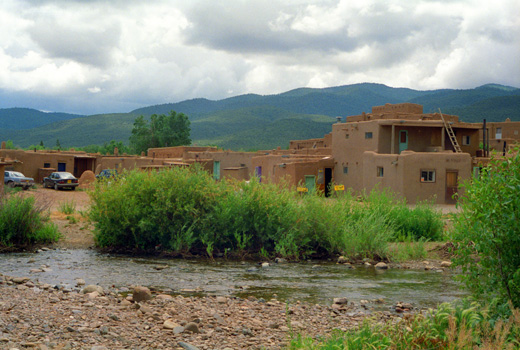 Homes on the South Side of the River |
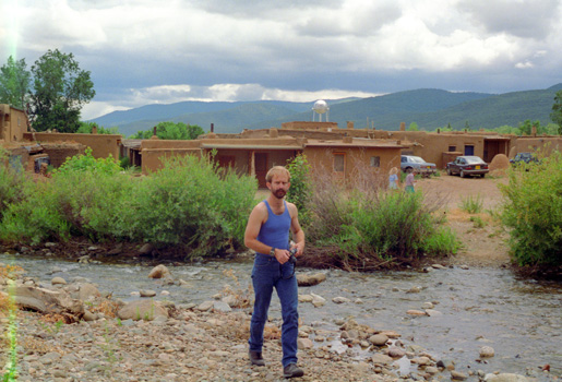 Fred by the River that Runs Through the Pueblo |
All in all, I found the pueblo interesting, but curiously non-authentic. I got the distinct impression that the whole thing was created only for the tourist trade, and that actual pueblo life was much different than that presented at the pueblo itself. I have nothing to base that on, but it was just a feeling that the whole thing was a reenactment rather than a live, functioning community (the resident vehicles sprinkled around not withstanding).
The Town of Taos, New Mexico
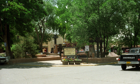 The Central Square in Taos, New Mexico There were a lot of stores here, many with items that were of good quality. I particularly liked some of the pottery items. |
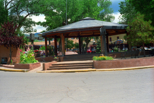 In the Central Square in Taos The central square is a gathering place, and I guess this building is used for that. It looks new, so I suppose it was built to beautify the central area of the town. |
In one of the shops, I found a Doolittle (Beth Doolittle does horse prints that are quite in demand) print that was mounted with what was supposed to be an authentic Indian arrow, and I bought it for my sister for Christmas. I also bought T-shirts for just about everybody, including two or three for myself. Fred found some T-shirts too, and changed into one of them right after he bought it. He also found a baseball cap that he liked, and when you see him next in a picture he will be in a different outfit. We had lunch at a nice restaurant, and then had ice cream at Baskin-Robbins.
At Rio Grande Gorge
|
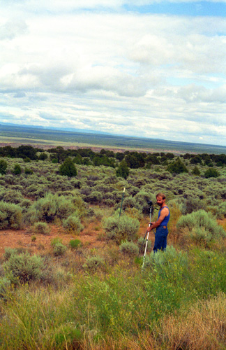
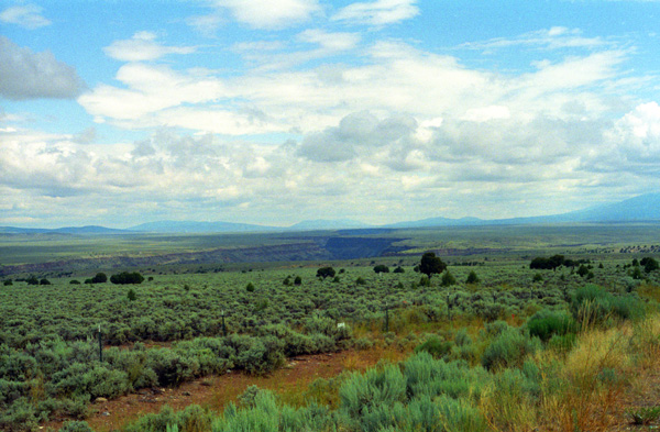
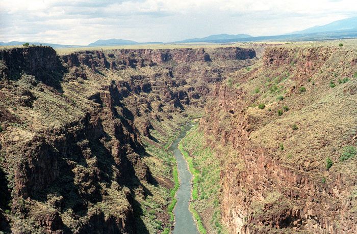
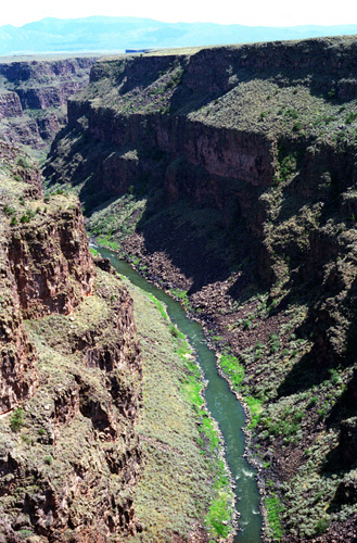
Here, the Rio Grande River appropriated a natural chasm, and has since cut an even deeper, spectacular gorge in the otherwise level plain of the high desert. The gorge is quite narrow for its depth, which is over 700 feet from the level of the bridge we are on. I suppose that eventually the canyon will get deeper and then begin to spread out, as at the Grand Canyon, but for now it is very deep and very narrow. Also very beautiful.
Geologically, the Rio Grande Gorge is a rift valley, a separation in the earth�s crust caused by faulting and other earth movements when the North American and Pacific plates scraped against each other some twenty-nine million years ago.
The canyon ecosystem descends 800 feet from rim to river, creating a unique diversity in plant and animal life. Ancient pi�on and juniper forests are home to 500-year-old trees. Wildlife include mule deer, red-tailed hawk, mountain blue-bird, and prairie dog. The climate here is semi-arid with summer thunderstorms common in July and August, and snow possible from November through March. Summer temperatures range from 45 to 90°F and in winter from -15 to 45°F.
|
|
Thinking about where the Rio Grande goes, I started thinking that I've never been to the Texas border with Mexico before. I should go down there sometime to see if the river looks much different than it does here.
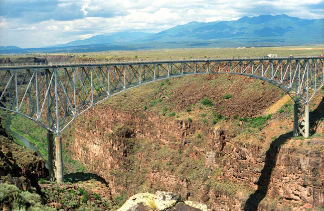
I've mentioned the Rio Grande Gorge Bridge a few times, so let's have a look at it through the photos we took. The Rio Grande Gorge Bridge, locally known as the "Gorge Bridge" or the "High Bridge", is a steel deck arch bridge. At 565 feet above the Rio Grande, it is the seventh highest bridge in the United States and 82nd highest bridge in the world.
|
The bridge was started in 1963 and completed in 1965. It was dedicated on September 10, 1965 and is a part of U.S. Route 64, a major east�west road. The span is 1,280 feet, consisting of two 300-foot-long approach spans with a 600-foot-long main center span.
In 1966 the American Institute of Steel Construction awarded the bridge "Most Beautiful Steel Bridge" in the "Long Span" category.
We parked the car in the east parking area, and the first thing we did was to walk out onto the bridge (and eventually all the way across it). The views from the bridge were very neat.
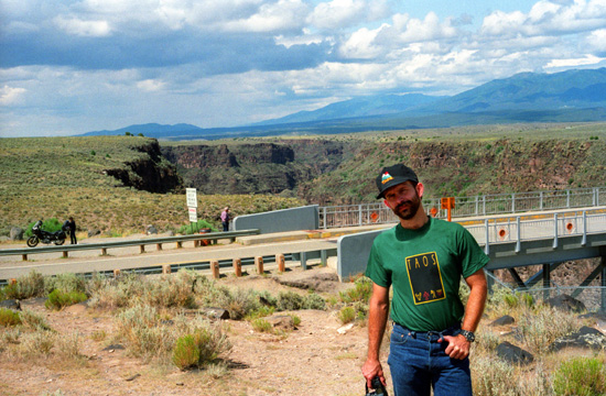
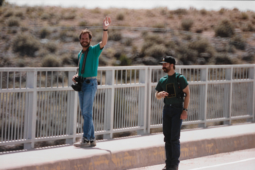 Fred and I on the Rio Grande Gorge Bridge Greg took this picture with his camera. Fred's fear of heights kept him from walking up along the railing where I am. No amount of coaxing was able to get him to stand up and look over the side of the bridge down to the river. He looks really good in the new T-shirt and Taos baseball cap. |
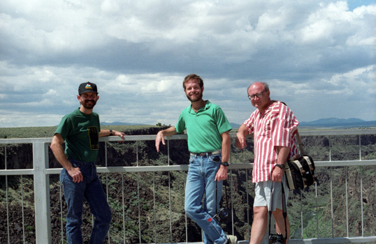 Fred, Myself and Greg on the Bridge This time, I got an obliging tourist use Fred's camera to take this picture of the three of us. |
Before I thought about getting a tourist to photograph us, Fred got a picture of Greg and me, but it was quite similar to the one of the three of us. You can, however, see it here.
 Looking East from the Bridge |
(Picture at left) No, I am not hanging off the side of the bridge to get this picture; there are a couple of spots where the sidewalk has been extended out so that people can get pictures like this one or look off the side of the bridge without getting in the way of traffic. The car is in the parking area that you can see at the other end of the bridge.
(Picture at right)
|
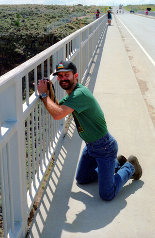 Fred on the Bridge |
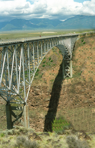
It was a beautiful afternoon, so we walked all the way across the bridge to the parking area on the other side. There, we found a short trail leading up to a rise from which there were good views of the entire bridge, so we headed up there to get some pictures.
|
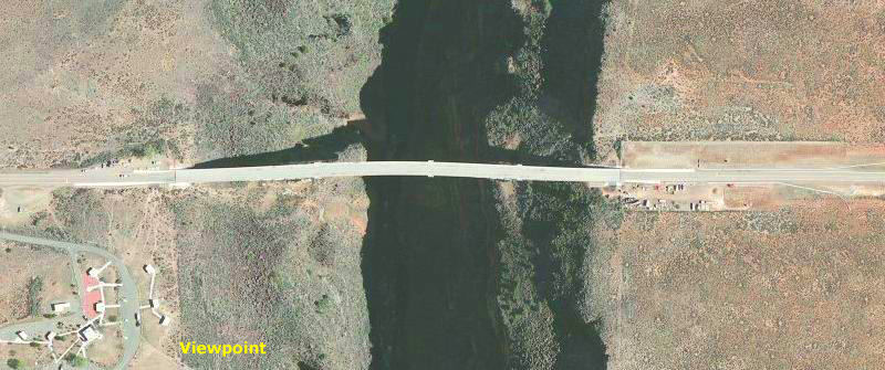
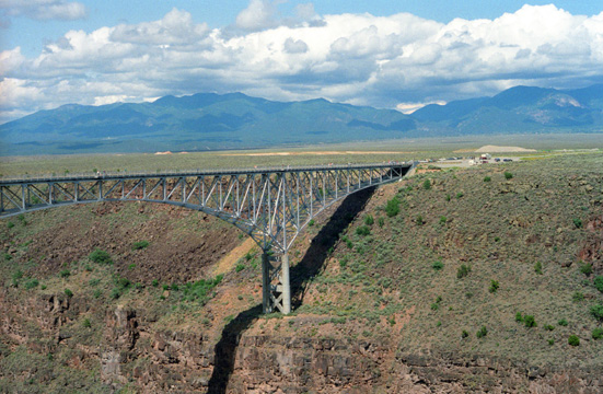
The aerial view does show the parking areas at both ends of the bridge (we did not know there might be one at the western end as well, or we might have driven, instead of walked, across the bridge. I do not recall the little buildings that you see in the current aerial view; my guess is that they are (or were) picnic shelters or some such.
Another oddity is that the bridge appears a bit curved, although it of course wasn't. I have noticed this anomaly in aerial view before, particularly of bridges, for some reason. I can only imagine it is some defect in the way the satellites photograph ground structures when they are not actually sitting on the ground. I recall seeing an aerial view of the bridge that will be constructed in 2010 over the canyon south of Lake Mead; in that one, it appears as if the roadway has actually sagged into the canyon. One of these days, I'll have to try to find out why this occurs. (NOTE: I just did this, and found out that the providers of satellite imagery tried to add a 3D characteristic to their views, but didn't get the coding quite right.)
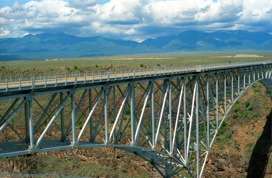 The Highway 64 Bridge over the Rio Grande This was one of the most graceful bridges I have ever seen. |
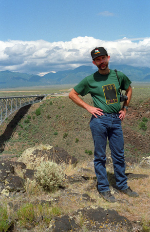
 Fred at the Western End of the Highway 64 Bridge The gorge itself and the Sangre de Cristo range are in the background. |
Fred looks a little put-out in the picture above. That's because he had been taking pictures all this morning until he noticed that the indicator on his camera passed 40 exposures for a 36-exposure roll. I suggested that he rewind the film and put in a new roll. When he did, and opened his camera, he found that he had neglected to put in any film at all. He was pretty upset at first, but realized that there wasn't anything he could do about it now. Fortunately, both Greg and I had taken quite a few pictures. I felt bad for him becauses he composes his shots so carefully, but he put in a roll of film and all was OK after that.
 Looking East Along the Bridge |
(Picture at left) This was taken from the overlook on the west side of the bridge.
(Picture at right)
|
 Fred at the Bridge Overlook |
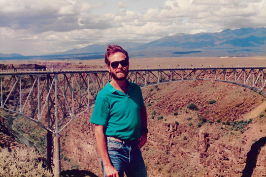 Me at the Highway 64 Bridge Fred got his camera working again, although the focus on this particular shot wasn't quite right. He took a somewhat better photo without me in it that you can see here. |
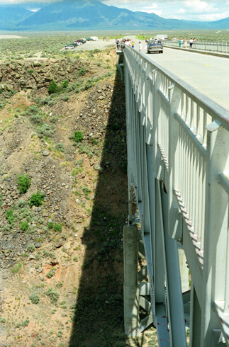
 My Last view of the Bridge I wanted to show how the ends of the bridge were anchored into the sides of the gorge. I certainly hope it is a long time before the river eats away enough of the side of the gorge to erode the support you see here. |
Some workmen re-mudding one of the buildings in downtown Santa Fe. We got back to Santa Fe about five in the afternoon, after spending an inordinate amount of time in a traffic jam in Espaniola. While Greg and Fred sat in the car stuck in traffic, I got out and walked about a mile ahead to the Baskin-Robbins where I got ice cream cones for each of them. By the time I got them and got back out to the street, they were pretty close and the traffic was breaking up. We found that there had been a parade that had just finished before we got there, coming back from the Rio Grande Gorge on Highway 285. Here, workmen are replacing adobe that has washed away from the side of this building. A common sight in Santa Fe. That evening, Greg's friend Steve invited us over to his house for dinner. He and the woman he lives with cooked a Mexican casserole that was quite delicious, and we had a good time at their house.
Our Evening in Santa Fe
That evening, Greg's friend Steve invited us over to his house for dinner. He and Mary cooked a Mexican casserole that was quite delicious, and we had a good time at their house.
You can use the links below to continue to another page for our Santa Fe weekend or return to the Index for this trip.
|
July 13, 1992: Bandelier NM and the Jemez Mountains |
|
July 11, 1992: Walking Around Santa Fe |
|
Return to the Index for the Santa Fe Trip |