|
October 26, 1992: Arches and Bridges National Parks |
|
October 24, 1992: Driving Through the San Juan Mountains |
|
Return to the Index for Our Western Trip |
The next morning, the weather was much better, so we set out for Mesa Verde.
Mesa Verde National Park
|
 |
(Incidentally, I have put an extract of the Mesa Verde Park Map in the scrollable window at left so you can get an idea of the layout of the park. If you will scroll all the way to the top right, you'll see the park entrance.)
We were also told that, this being a Sunday on a Fall weekend, that it was entirely possible that tour spaces were already full if not all day then into mid-afternoon (longer than we could stay and still get to our campground in Utah this evening). When we got down to the museum, we found that the next tour space was at 3:30, and that would be too late for us.
So we reluctantly put Balcony House on our list of things to do here on another visit, and we went off to have a look at Spruce Tree House. (As it turned out, we were actually able to tour Balcony House next year.) Mesa Verde National Park is not only a National Park but also a World Heritage Site; it protects some of the best preserved Ancestral Puebloan archeological sites in the United States. The park was created by President Theodore Roosevelt in 1906. It occupies 52,485 acres, and with more than 4,300 sites, including 600 cliff dwellings, it is the largest archeological preserve in the United States. Mesa Verde (Spanish for "green table") is best known for structures such as Cliff Palace, thought to be the largest cliff dwelling in North America.
|
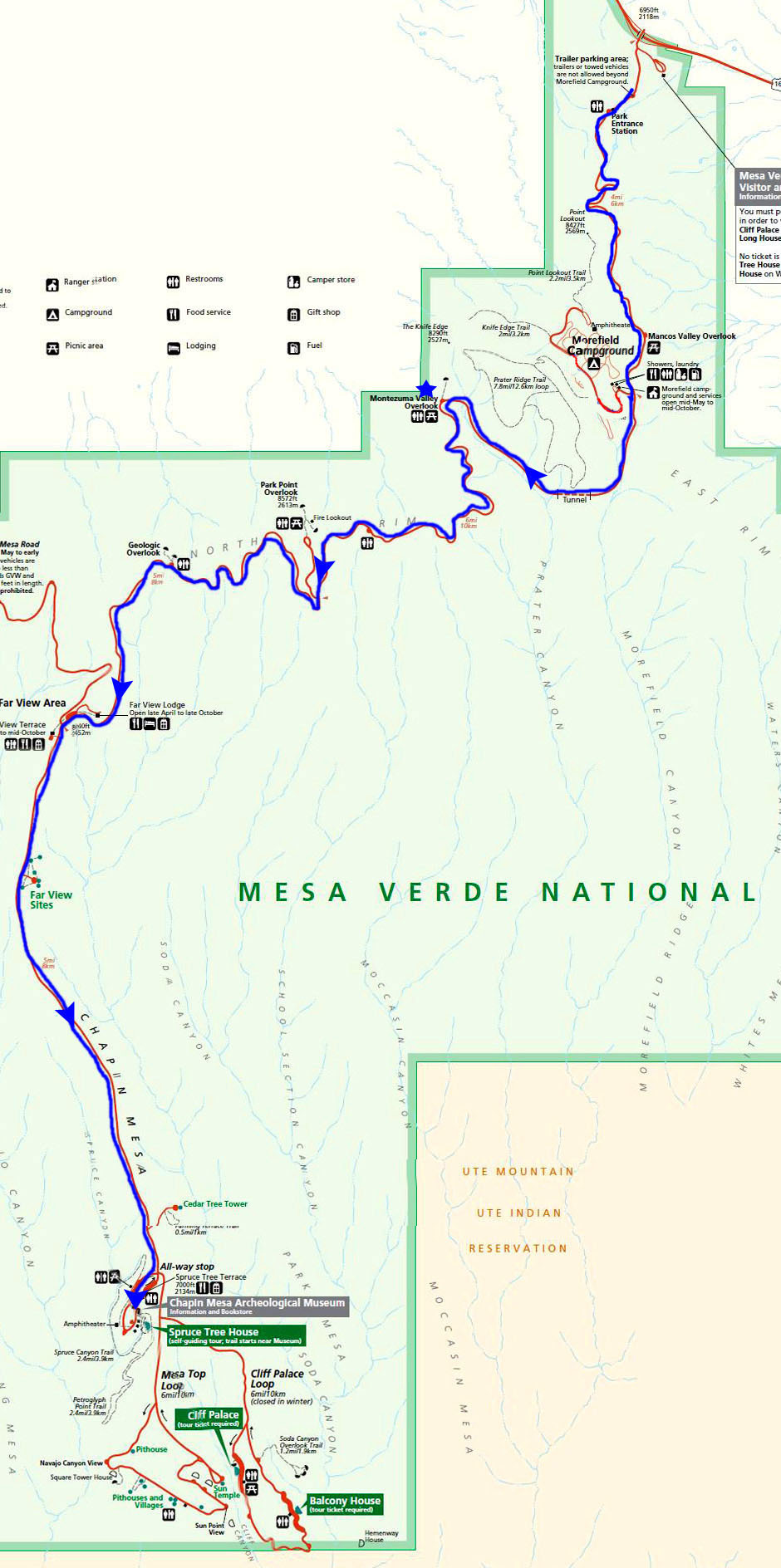
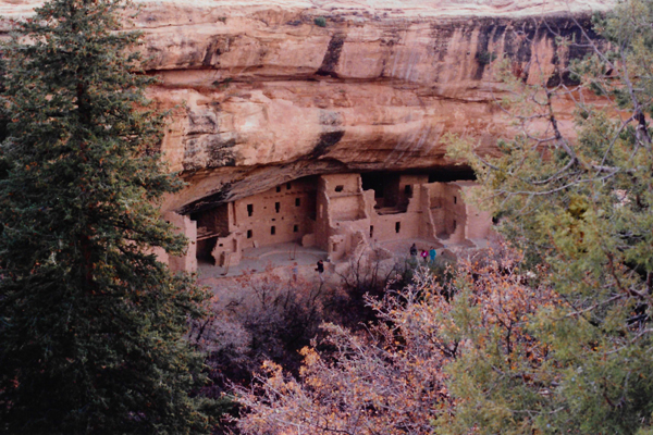
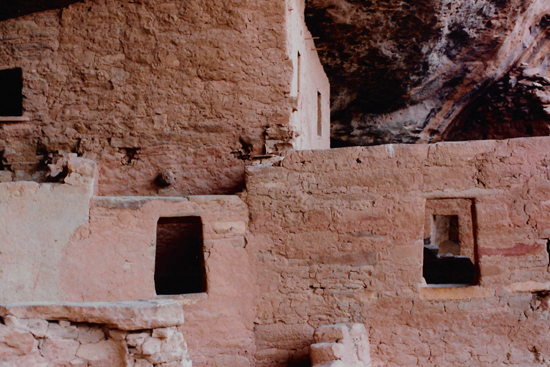
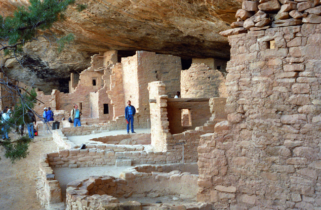
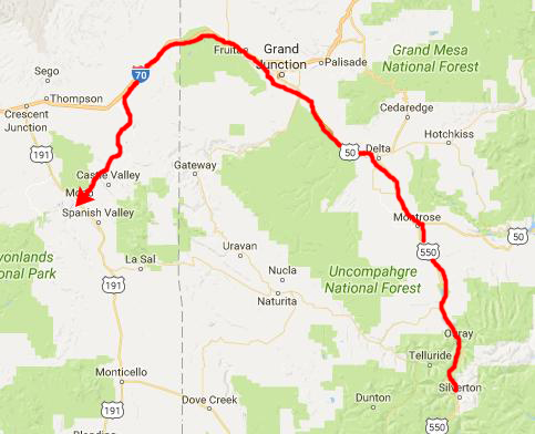
Here is a view of Spruce Tree House from the top of the short trail that leads down to it. There are quite a few cliff dwellings at Mesa Verde, and Fred picked one that was representative of them all. Some of the dwellings, like Balcony House, are more fragile and/or harder to get to, so those tours are guided. But Spruce Tree House is a tour that you can take at your own pace.
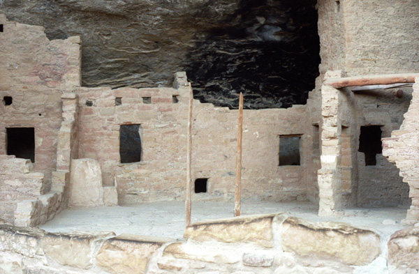
So we began the short trek down the hill to the dwellings. This picture was taken from near the top of the trail down to the dwellings. You can get a good idea of why the cliff dwellings were built where they were. The rock overhang at this site provides a large measure of protection from the weather and also from both animals and other human beings. The people who built these dwellings are known by the general name of the Anasazi; there is no record of what they called themselves, so that is the name that they have been given.
The cliff dwelling was first discovered in 1888, when two local ranchers chanced upon it while searching for stray cattle. A large tree, which they identified as a Douglas Spruce (later called Douglas Fir), was found growing from the front of the dwelling to the mesa top. It is said that the men first entered the dwelling by climbing down this tree, which was later cut down by another early explorer.
|
Dr. Jesse Walter Fewkes of the Smithsonian Institution opened Mesa Verde Spruce Tree House for visitation following excavation in 1908. Dr. Fewkes removed the debris of fallen walls and roofs and stabilized the remaining walls. Due to the protection of the overhanging cliff, Mesa Verde Spruce Tree House had deteriorated very little through the years and has required little supportive maintenance.
Starting around 7500 BC, Mesa Verde was seasonally inhabited by a group of nomadic Paleo-Indians known as the Foothills Mountain Complex. The variety of projectile points found in the region indicates they were influenced by surrounding areas, including the Great Basin, the San Juan Basin, and the Rio Grande Valley. Later, Archaic people established semi-permanent rockshelters in and around the mesa. By 1000 BC, the Basketmaker culture emerged from the local Archaic population, and by 750 AD the Ancestral Puebloans had developed from the Basketmaker culture.
|
|
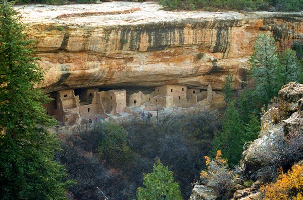
In area after area of the dwelling you can see up close the construction methods that were employed, and one is continually amazed how, for their simplicity, these methods have resulted in construction that has endured so long. Inside, there are rooms and stairs much like in a contemporary dwelling. You can see that the upper edge of the highest walls was built to follow the line of the overhanging cliff. The bricks of adobe are surprisingly regular. Constructing the complex took as long as thirty years- it was a very slow process.
The Mesa Verdeans survived using a combination of hunting, gathering, and subsistence farming of crops such as corn, beans, and squash. They built the mesa's first pueblos sometime after 650 AD, and by the end of the 12th century they began to construct the massive cliff dwellings for which the park is best known. By 1285, following a period of social and environmental instability driven by a series of severe and prolonged droughts, they abandoned the area and moved south to locations in Arizona and New Mexico, including Rio Chama, Pajarito Plateau, and Santa Fe.
|
Spruce Tree House was built during the "Pueblo III Period" (1150 to 1300). A severe southwest drought (1130 to 1180) led to rapid depopulation in many parts of the San Juan Basin, particularly at Chaco Canyon. As the extensive Chacoan system collapsed, people increasingly migrated to Mesa Verde, causing major population growth in the area. This led to much larger settlements of six to eight hundred people, which reduced mobility for Mesa Verdeans, who had in the past frequently relocated their dwellings and fields as part of their agriculture strategy. In order to sustain these larger populations, they dedicated more and more of their labor to farming.
The Chacoan system brought large quantities of imported goods to Mesa Verde during the late 11th and early 12th centuries, including pottery, shells, and turquoise, but by the late 12th century, as the system collapsed, the amount of goods imported by the mesa quickly declined, and Mesa Verde became isolated from the surrounding region. For approximately six hundred years, most Mesa Verdean farmers had lived in small, mesa-top homesteads of one or two families. They were typically located near their fields and walking distance to sources of water. This practice continued into the mid- to late 12th century, but by the start of the 13th century they began living in canyon locations that were close to water sources and within walking distance of their fields.
|
|
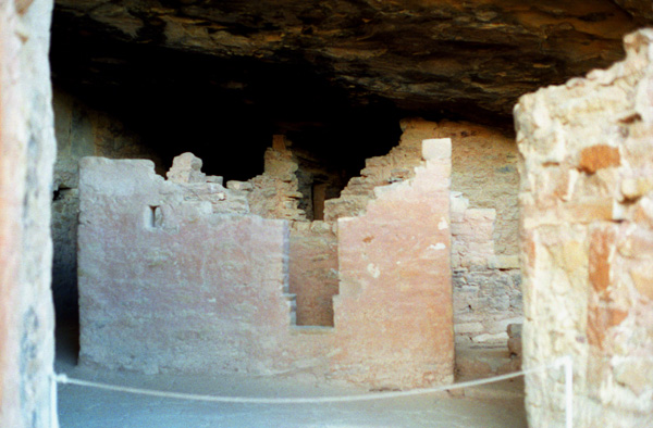
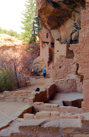
In the picture at left, you can again see in detail the construction methods that were used at Spruce Tree House. Note in the lower right the line up of the windows through three walls. Also, at the left of the picture, you can see some of the minor restoration that has been done by the Park Service. They have replaced a small section of one of the walls with a concrete mixture that blends in as well as possible with the existing walls. If you continue the roof line of the room at the right across the picture to the left, you can see the line of the floor in the two-story section.
Mesa Verdean villages thrived during the mid-Pueblo III Era, when architects constructed massive, multi-story buildings, and artisans adorned pottery with increasingly elaborate designs. Structures built during this period have been described as "among the world's greatest archaeological treasures". Pueblo III masonry buildings were typically occupied for approximately fifty years, more than double the usable lifespan of earlier structures, although some were continuously inhabited for hundreds of years. Architectural innovations such as towers and multi-walled structures also appeared during the Pueblo III Era.
|
Mesa Verde's population remained fairly stable during the 12th century drought. At the start of the 13th century, approximately 22,000 people lived in the area. There were moderate population increases during the following decades, and dramatic ones from 1225 to 1260. Most of the people in the region lived in the plains west of the mesa at locations such as Yellow Jacket Pueblo, near Cortez, Colorado. Others colonized canyon rims and slopes in multi-family structures that grew to unprecedented size as populations swelled. By 1260, the majority of Mesa Verdeans lived in large pueblos that housed several families and more than one hundred people.
|
The 13th century saw 69 years of below average rainfall in the Mesa Verde region, and after 1270 the area suffered from especially cold temperatures. Dendrochronology indicates that the last tree felled for construction on the mesa was cut in 1281. There was a major decline in ceramic imports to the region during this time, but local production remained steady. Despite challenging conditions, the Puebloans continued to farm the area until a severely dry period from 1276 to 1299 ended seven hundred years of continuous human occupation at Mesa Verde. Archeologists refer to this period as the "Great Drought"; the last inhabitants of the mesa left the area around 1285.
The structures contained within these alcoves were mostly blocks of hard sandstone, held together and plastered with adobe mortar. Specific constructions had many similarities but were generally unique in form due to the individual topography of different alcoves along the canyon walls. In marked contrast to earlier constructions and villages on top of the mesas, the cliff dwellings of Mesa Verde reflected a region-wide trend towards the aggregation of growing regional populations into close, highly defensible quarters during the 13th century.
While we were in the last section of the Spruce Tree House ruins, I saw a ranger and asked what had caused the inhabitants to leave. As at other sites in the southwest, he said, we really don't know for sure why, within such a short span of time, the inhabitants decamped for other locations unknown. Perhaps it was the drought, but it could have been something else.
After finishing the tour of Spruce Tree House, we stopped at a couple of very small sites, but decided not to try to go through another of the major dwellings. Fred suggested that we save them for another time. So we drove back on the ridge road on top of the mesa towards the entrance to the Park.
Leaving Mesa Verde National Park
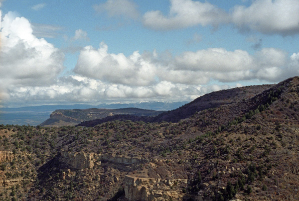
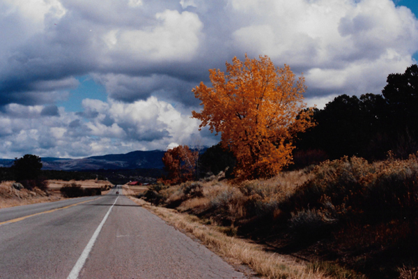
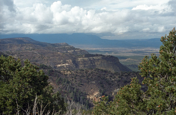
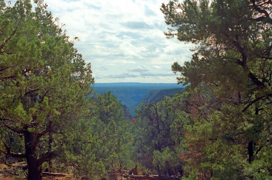 Looking West from the Mesa Verde Park Road Both West and South of the Mesa Verde National Park, the area is mostly wooded, as this view to the West shows. To the North and Northeast, there is a fertile valley, at one end of which is the town of Durango. This view is typical of the views to the West. |
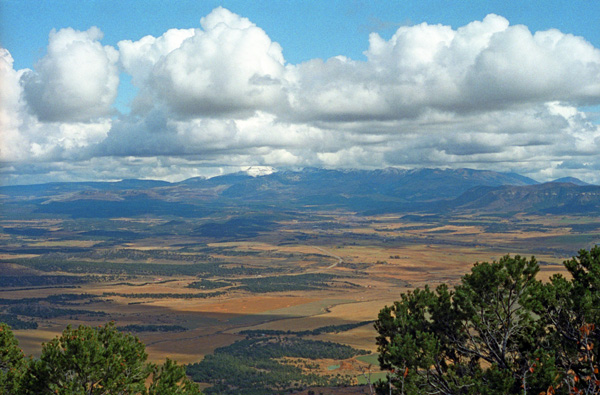
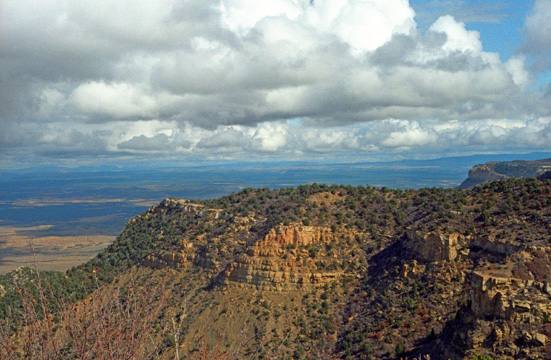 The Valley to the North of Mesa Verde You can see the park road just below that ridge crest as it circles around the far end of the bluff. Beyond is a farming valley given over to cultivation and grazing. All of the land in the far distance is part of Colorado, as you are looking almost exactly due North. It does appear as if you are at the roof of the West; the clouds seem to be so close from this vantage point. |
|
|
The mist and rain that we encountered in Durango turned to snow at the nine thousand foot level, and of course Wolf Creek Pass is over ten thousand feet. We heard on the radio that almost half a foot of wet snow had fallen overnight. I don't get to see that much snow these days (hooray), so seeing some is always a treat. More so because it isn't in my driveway.
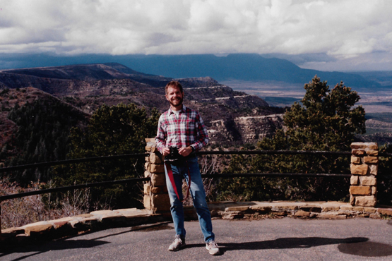
At the next overlook that we came to, the views to the northwest opened up, and both the pictures below were taken from the same overlook (one by Fred and one by me) looking in that direction. You can see in both pictures that some weather seems to be moving in; it has gotten cloudier as the day progressed. I usually tend to forget to put people in my pictures, and that's unfair to Fred, because he usually tries to get me in his.
 |
 |
We were almost out of the park, now, and so as we drove the last few miles, Fred summarized the history of the park for me, reading from our brochure:
| "In 1765, Don Juan Maria de Rivera led what was possibly the first expedition of white men northwest from New Mexico and, although they did not identify Mesa Verde, mentioned in their journals the ancient "ruins" they found. The first European known to climb onto the mesa, was geologist Dr. John S. Newberry, a member of the 1859 San Juan Exploring Expedition. Although he didn�t record finding any archeological sites, the expedition was the first to officially use the name Mesa Verde. Fifteen years later, pioneer photographer William Henry Jackson was introduced to rancher and explorer John Moss, who led him into Mancos Canyon, where Jackson entered Two Story House, and took the first photographs of a cliff dwelling in the Mesa Verde region. Two years later, Sixteen Window House was discovered and named. Prospector S. E. Osborn spent the winter of 1883-84 in the canyons of Mesa Verde and later wrote about many of the sites he saw. Many believe he is the first documented visitor to enter Balcony House; his name and the date March 20, 1884, were carved in a nearby dwelling in lower Soda Canyon. The first known suggestion that the area be set aside as a national park appeared in an editorial in the Denver Tribune Republican on December 12, 1886. The editor was concerned that "vandals of modern civilization" were destroying the sites and that the area needed Federal or State protection. Local rancher Richard Wetherill and his brothers made several trips into Mesa Verde (1888-1892), primarily for collecting archeological material. The Wetherill parties discovered Cliff Palace, Spruce Tree House and Square Tower House, entering and exploring all three. The Wetherill brothers explored the Mesa Verde "ruins" and reported having entered 182 cliff dwellings, and the elder Wetherill wrote to the Smithsonian Institute multiple times, proposing that the entire area be set aside as a National Park in order to preserve the cliff dwellings; he feared that if this was not done "the tourists, will destroy them."
In 1891, Baron Gustaf E. A. Nordenski�ld, of the Academy of Sciences in Sweden and the first scientist to visit Mesa Verde, used painstaking field methods for his time to excavate, sketch, and photograph numerous sites. He collected about 600 items which now reside in the National Museum in Helsinki, Finland. His book, The Cliff Dwellers of the Mesa Verde, was the first extensive examination and photographic record of Mesa Verde�s cliff dwellings. The Colorado Cliff Dwellings Association was formed in 1900, with its sole purpose to preserve the cliff dwellings of the Mesa Verde area. They promoted their campaign to make Mesa Verde a national park through letter writing, fund raising, and even tours of Mesa Verde for the press. In February, 1901, the first bill was introduced before Congress to create "Colorado Cliff Dwellings National Park," but it did not pass. At least four more bills were introduced during the following years, but all failed. Finally, in 1905, a bill for the creation of Mesa Verde National Park was introduced in the 59th Congress and subsequently passed and signed by President Theodore Roosevelt. The Park was officially created on June 29, 1906. Earlier that same month the "1906 Antiquities Act" was passed, making it a federal crime to collect or destroy any historic or prehistoric object or building on federally owned land. Excavation and repair of major sites began in 1908 so visitors could see and enjoy the park. Most of the early work was done by Jesse Walter Fewkes, an archeologist from the Smithsonian Institution. The New Deal, launched in 1933, brought the Civilian Conservation Corps (CCC) to Mesa Verde. The CCC and other depression era efforts employed young men and women to build trails and roads, operate switchboards, help in archaeological excavations, fight fires, build park buildings, and create museum exhibits. Much of their work is still in use today." |
The Drive Through Silverton to Our Utah Campsite
|
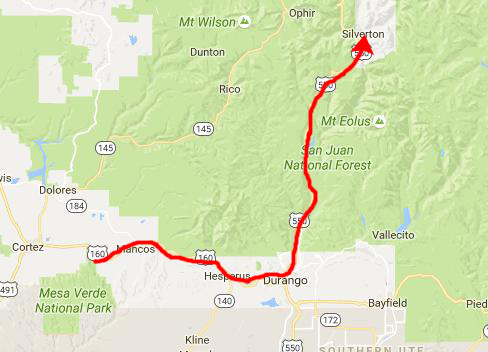 |
On the inset map above, right, you can see our route back through Durango and up to Silverton on US Highway 550. As we climbed out of Durango, the weather turned chillier and cloudier. There was even some snow.
|
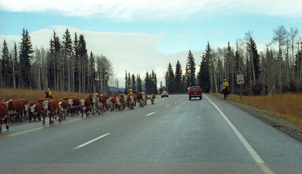
The reason was this "cattle drive" along the highway. Even a dummy could see that winter was on its way, and evidently these cowboys were preparing for just that, and they brought some of their cattle from the upper pastures North of Durango to pastures lower down in the valley where Durango is. The best route to take from one to the other is along this nice paved road. Quite a difference from driving cattle across open range. The cattle seemed to be totally unconcerned about all the passing cars.
We continued our drive north, and after an hour or so we were approaching Silverton.
|
|
We were, of course, heading towards Silverton, a town we'd looked up and knew would be picturesque. Silverton is a former silver mining camp, most or all of which is now included in a federally designated National Historic Landmark District, the Silverton Historic District. The town's population is about 450.
Silverton is linked to Durango by the Durango and Silverton Narrow Gauge Railroad, a National Historic Landmark. Silverton no longer has active mining, but subsists by tourism, maintenance of US 550, mine pollution remediation, and retirees. The town was founded when a group of prospectors found traces of placer gold in the San Juan Mountains in 1860 at Eureka, Colorado. They were forced out by the Ute Tribe in 1861, as they had been awarded the area in a US treaty. They returned in 1871, when lode gold was found in the Little Giant vein at Arrastre Gulch. The miners were allowed to stay after the Brunot Treaty of 1873. In exchange for giving up 4 million acres, the Southern Ute Indian Reservation received $25,000 per year (which was a heck of a lot back then).
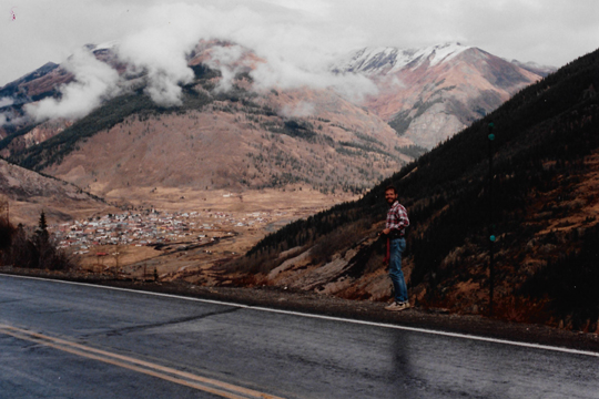
Eventually, Highway 550 wound around a final curve and we could see the town of Silverton down in the valley ahead of us. These pictures of the town, nestled in this small valley in the Western part of Colorado, are very neat, I think. Although I don't have my jacket on, the weather seemed to be getting progressively colder as we moved North.
 |
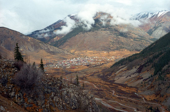 |
Actually, I think the second (right-hand) picture is one of the best of the trip, and if you would like to see a larger version of it, just click here.
Silverton looked like such a neat town that we thought we might stop and drive down into it and have a quick look around. Fred has taken the Durango-Silverton train before, so this was his second visit. We drove first to the train station area to have a look at the Durango-Silverton excursion train.
|
|
The route was originally opened in 1882 by the Denver & Rio Grande Railway (D&RG) to transport silver and gold ore mined from the San Juan Mountains. The line was an extension of the D&RG 3 ft narrow gauge line from Antonito, Colorado, to Durango. The last train to operate into Durango from the east was on December 6, 1968. The states of New Mexico and Colorado purchased 64 miles between Antonito and Chama, New Mexico, in 1970 and operates today as the Cumbres & Toltec Scenic Railroad. Trackage between Chama and Durango was removed by 1971.
The line from Durango to Silverton has run continuously since 1881, although it is now a tourist and heritage line hauling passengers, and is one of the few places in the U.S. which has seen continuous use of steam locomotives. In March 1981, the Denver & Rio Grande Western sold the line and the D&SNG was formed. Some rolling stock dates back to the 1880s. Trains operate from Durango to the Cascade Wye in the winter months and Durango-Silverton during the summer months. Durango depot was built in January 1882 and has been preserved in original form.
Here are two more pictures of the Durango-Silverton train that we took today:
 Another View of the Durango & Silverton Train The train in the previous picture backed up to change tracks for the run back down to Durango. The track curves around to the left at the left side of the picture so that tourists can board the train literally in the middle of town. |
 The Durango & Silverton Railroad Fred was on the other side of the station building, and took this shot of the same train as I was looking at in the previous picture. It is rare that one gets to see such vintage engines as this one. |
Fred and I walked around the town for a while, and drove up in the hills North of town to look through some of the graveyard stones there. Fred had read that some famous desperadoes where buried there, and we were trying to find some of their graves, but we did not. We got some good local history, though, by reading some of the stones.
|
It started raining about an hour outside of Silverton, and continued until almost Grand Junction. Along the way, we found one Baskin-Robbins store in Montrose, and found another in Grand Junction. By the time we got there, it was dark (although dark at this time of year is about six-thirty. We headed West on Interstate 70, crossing into Utah about eight in the evening. Our next stop was to be Arches National Park in Eastern Utah, so about ten miles into the state we got off of the Interstate and headed South on Utah Highway 128 through what appeared to be a very flat area of Utah.
The road we were on seemed to be passing through a very desolate area. At least, we saw very few lights anywhere, and very few cars passed us on the road. All we saw were stars and a bit of ambient light on both sides of us. After a while, the darkness along the east side of the road seemed to be getting deeper- I couldn't even see any stars on one whole side of the road. We were looking for a place we could stop and camp for the night which is why I noticed the unusual darkness. We got more an more curious, so we stopped and pulled off the road to get out and have a look. As soon as I turned off the headlights and our eyes adjusted to the darkness, we saw that, unbeknownst to us in the darkness, the entire Eastern side of the road had turned from flat desert terrain into a sheer cliff, and the road was now hugging this cliff, as the Colorado River had appeared on the other side of the road. It was very eerie, looking directly up at this sheer cliff- and also a little frightening. It is hard to describe the sensation.
About ten or fifteen miles before we would have arrived in Moab, Utah, we came across the Drinks Canyon Campground, so we decided to stop here for the night. We pulled in to a really nice campsite right by the Colorado River, set up the tent, had some sandwiches for dinner, and retired for the night. The sound of rushing water was very soothing and sleep came easily.
You can use the links below to continue to another photo album page for our Western Trip or return to the Index to continue through the photo album.
|
October 26, 1992: Arches and Bridges National Parks |
|
October 24, 1992: Driving Through the San Juan Mountains |
|
Return to the Index for Our Western Trip |