|
July 23, 1993: Lost Valley and the Buffalo River |
|
Return to the Arkansas Trip Index |
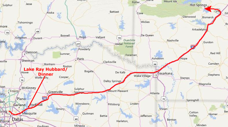
We have had our Arkansas trip planned for months, and Fred has Thursday and Friday, July 22-23, off. Between the time we planned and this week, I had been given a team consulting assignment in Austin that was supposed to last all week. Rather than cancel our trip, which would be hard for Fred because his vacation time was set, I came back early from the assignment; I was lucky that it was a team effort and that I could complete my portion by working long hours Monday through Wednesday afternoon. I got back to Dallas just in time to pick up my camera from the camera repair (it had been there since our trip to Zion).
Getting to Hot Springs, Arkansas
|
Incidentally, I had not seen the lake since I came here to carry out the final part of Gran't wishes- that some of his ashes be spread here at the lake, in memory of all the good times we had sailing here. (I did that last year after travelling to both Chicago and to Fort Lauderdale to put some of the ashes in Grant Harbor and in the Intracoastal Waterway.) Regardless of what anyone might think about ashes-scattering, it is a common occurrence, I think. (I was to find out a year or so hence that Fred, too, wants something particular done with his own remains- he wants some of them left in the Wichita Mountains Wildlife Refuge up in Oklahoma, and, after our first visit there, I understood why.)
We drove for about four hours more, and got to Hot Springs very late- about one in the morning. Fred had made some reservations at a place that the AAA guide described as being quite nice, but he was somewhat dismayed to find the place not as nice as he had hoped. He always thinks that I feel put out when we don't stay in the nicest places. I have some trouble telling him that I am not one of these travelers who has to stay in a Hyatt Regency all the time (in fact, I much prefer smaller, less opulent surroundings- even when the client is paying); it is a constant joke. I do draw the line somewhere, but we haven't found that yet.
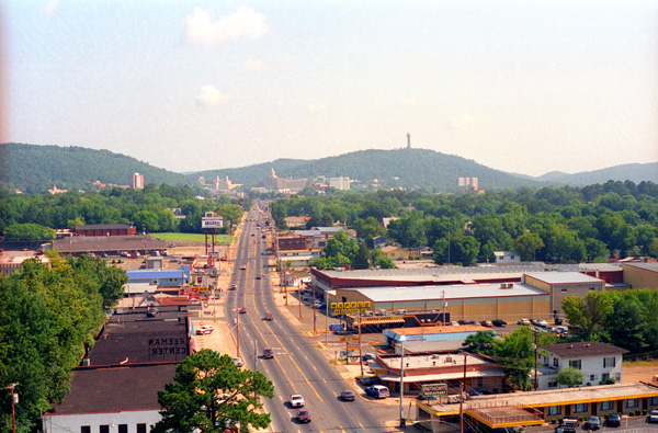
Hot Springs, Arkansas and Hot Springs National Park
|
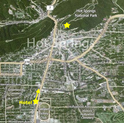
I might have included an aerial view of the hotel itself, but what is happening more and more as I work backward in time through my photos is that the way something was 20+ years ago is sometimes nothing like it is today, and so aerial views are at times very much out-of-date. This one certainly would be, if I got any closer. The hotel where we stayed isn't there any more. Anyway, we had a good night's sleep and were up and out of the hotel about nine-thirty. I had not had time to change the oil in my car before leaving, so we stopped to do that, and we also got some breakfast. By the time that was done, the only Baskin-Robbins in Hot Springs was open so I was able to add it to my list.
After that, it was off to Hot Springs National Park in the center of town. I should probably say right now that today was probably one of the hottest, most humid days we have had on any trip we've taken thus far. I guess that the temperature is only in the low 90s, but it seemed as if the humity was pretty close to 100%. I was happy to have the ice cream, but an hour later we were both already very aware of the morning heat.
|
Indigenous peoples have been visiting this site for thousands of years; at the time the Spanish arrived (de Soto in 1541- the first known European to see the springs), it was called the "Valley of the Vapors". Early Americans had been using the springs for 8,000 years, enjoying the healing properties of the thermal springs. The Caddo, Choctaw, Cherokee, and other tribes from the Southeast all used the area, under an agreement that they would put aside their weapons and partake of the healing waters in peace while in the valley. The Quapaw lived permanently in the area around the springs.
Control of the area alternated between Spain and France until the Louisiana Purchase of 1803. In the following year, William Dunbar and George Hunter made an expedition to the Ouachita Mountains and the springs at the request of President Thomas Jefferson, to study the native peoples, flora and fauna. They found one log cabin and a few rudimentary shelters. In 1807 the first European-American settled arrived; not long after, trappers and other settlers arrived and a few stayed, putting up cabins for other visitors.
In 1818, the Quapaw Indians ceded the land around the hot springs to the United States, and the Arkansas Territorial Legislature requested in 1820 that the springs and adjoining mountains be set aside as a federal reservation which was done 12 years later. The Hot Springs Reservation was set aside for public use as a park on June 16, 1880.
|
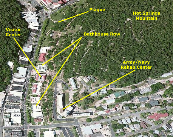
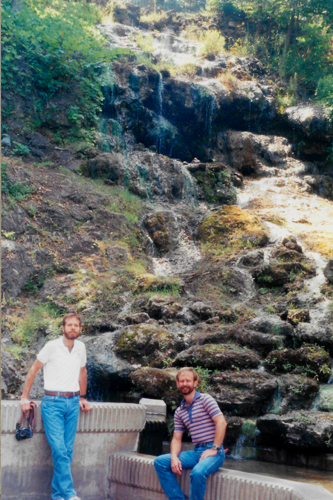
We walked up the walkway to the visitor center, but Fred spotted a park ranger taking a group of people around, so we joined them. We learned something about the springs (Fred had been here before), and then we went down the hill to where one of the springs comes out of the rock into a pool built for it. In the picture at left you can see the water cascading down the rock face behind us. I look a bit pained in this picture, but I think it was because it was so hot. You could feel the heat from the water, too.
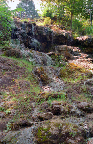
The springs are all grouped about the base of the Hot Springs Mountain, with a flow of well over a half million gallons a day. The hot water is supplied to the various bathhouses, with resulting income from concession fees going to the U.S. Treasury. The park has miles of roads and trails over the mountains. The park is open throughout the year.
The first bathhouses were little more than brush huts and log cabins placed over excavations cut in the rocks to receive hot water that flowed from the springs. Entrepreneurs soon developed more elaborate bathing facilities, featuring wooden troughs delivering water from hillside springs to bathhouses along the east bank of Hot Springs Creek. Some of the tufa covering the hillside was excavated to accommodate the bathhouses. The narrow street along the west side of the creek was connected to the bathhouses by narrow bridges. "Bathhouse Row", as it is called, has been a fixture of Hot Springs for a century.
We had no desire to "take the waters," but from the earliest it was believed the waters benefited diseases of the skin and blood, nervous affections, rheumatism and kindred diseases, and the "various diseases of women". The earliest bathing procedure consisted of merely reclining in natural pools of hot springs and cool creek water for long periods of time. During the 1820s crude vapor baths stood over the springs, and bathers breathed in the vapors for extended periods of time. Wooden tubs were added to some bathhouses in the 1830s and physicians began arriving in the 1850s.
Physicians prescribed various types of baths for patients. It was thought that profuse perspiration was an active agent in fighting disease. The advice of a physician who was familiar with the use of the waters was considered necessary to avoid injury. In many cases medicine was required before using the waters, although it had been observed that the amount of drugs given was "enough to sicken a well man."
The usual regimen was a multi-week course of daily baths followed by a few days' rest and then another course. The water was often in excess of 125�F, so baths had to be short, and recovery was required after only 10 to 20 minutes. Eventually, the Park's superintendent set various rules regarding temperature, length of time and ancillary services. By 1980 one reporter described getting a 20-minute bath, two minutes in a steam bath, 15 minutes wrapped with hot packs, and resting in a cooling room for 20�30 minutes.
|
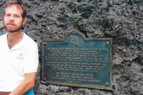
At the corner of the park, we found this plaque commemorating the Hot Springs. The inscription reads:
|
| "This valley, long known to the Indians as 'ta-ne-do', 'the place of the hot waters', and according to tradition dedicated by the different tribes as sacred ground, was first visited by white men on September 18, 1541, when Fernando de Soto and his men arrived in this valley and were met here by the Indians. According to records of Roderigo Rowel, secretary to De Soto and the 'Gentleman of Elvaz' who was also a member of the company, they bathed in the hot waters and departed on October 3, 1541." |
There is actually a significant amount of heat generated by the water. There are many baths in Hot Springs, most of which still operate, that have channeled the water into an underground reservoir into which all the bath houses tap. I don't think that Hot Springs is as popular a place as it must have been at one time. There are many large hotels built for the trade early in this century, but they don't look crowded now. The town seems pretty active, but I think in the Summer it is too oppressive.
The Ouachita National Forest
|
|
Ouachita is the French spelling of the Indian word Washita, which means "good hunting grounds." The forest was known as Arkansas National Forest on its establishment in 1907; the name was changed in 1926.
Rich in history, the rugged and scenic Ouachita Mountains were first explored in 1541 by Hernando de Soto's party of Spaniards. French explorers followed, flavoring the region with names like Fourche La Fave River. The area including the forest nearly became a national park during the 1920s, but a last-minute pocket veto by U.S. President Calvin Coolidge ended the effort after opposition from the National Park Service. It thought the area too close to the new Hot Springs National Park.
|
|
The Forest contains extensive woodlands of stunted Northern Red Oak, White Oak, Post Oak, and Blackjack Oak at elevations over 2,500 feet and on steep, dry slopes. These woodlands, of little commercial value, were never logged and the extent of old growth forest within them may total nearly 800,000 acres. There are also old-growth woodlands of Eastern Redcedar, Gum Bumelia, Winged Elm, and Yaupon along some streams.
In a magazine article written as part of the effort to make the area a national park, Arkansas State Representative Osro Cobb, a proponent of the plan, described the area that he had sought to protect for future generations, many of whom could not afford long trips to the national parks in the western states. He compared flora and fauna in the Ouachita forest to those of the southern Alleghenies, and continued:
| "A visitor standing upon one of the many majestic peaks in the area of the proposed park is thrilled by a panoramic view that cannot be had elsewhere in the South Central States. With cheeks flushed by the invigorating mountain beezes, the mountain climber is rewarded by an inspiring view of countless and nameless peaks, mountain groups, dense forests, and inviting valleys, all merging into the distant horizon. There are many mountain streams, now moving slowly in narrow but deep pools, then churning with savage ferocity down some water-worn precipice, leaving in its wake snow-white sprays. Fed by crystal springs and like so much molten silver these streams flow their turbulent courses unappreciated and rarely visited." |
|
|
Two wilderness areas are found in the forest, protecting the sections of the forest that have had the least amount of human intervention. The 13,139-acre Black Fork Mountain Wilderness is located in both Arkansas and Oklahoma and contains significant old-growth forests; the Upper Kiamichi River Wilderness is located solely in Oklahoma.
Rockhounds frequent a belt several miles wide containing concentrations of quartz crystals. Visitors and rock collectors are free to pick up loose crystals within the belt for personal use and may dig for quartz with the permission of the district ranger.
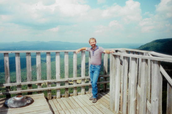
We took two more pictures here in the Ouachita National Forest:
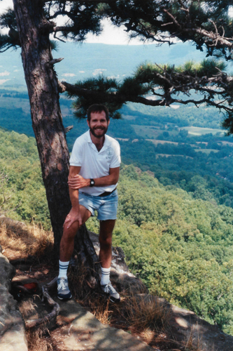
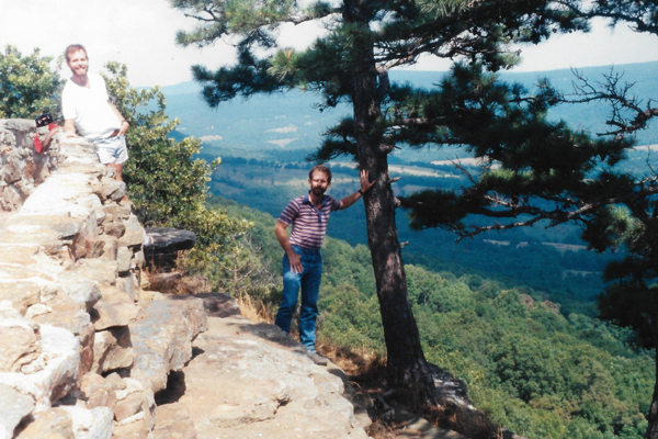
 The Ouachita National Forest |
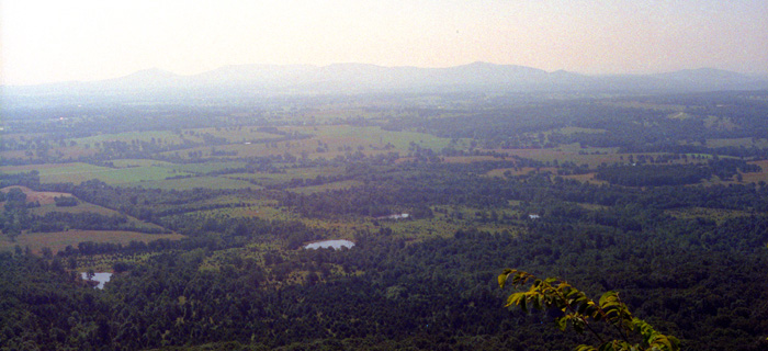
 At the National Forest Overlook |
Cave Mountain Cave
 |
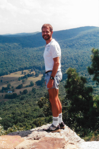
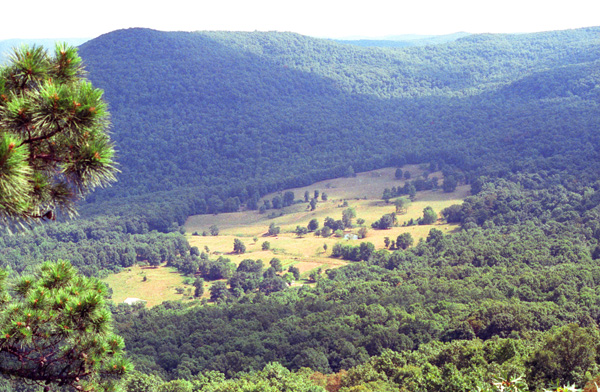
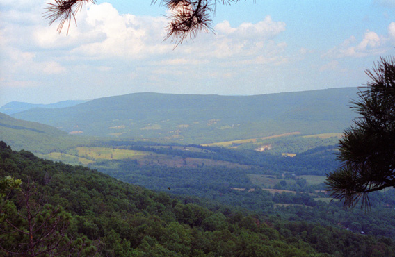
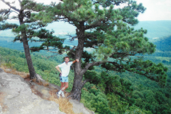
Just before we reached the Buffalo River itself, we stopped at a mountain store; it advertised a free overlook of the Buffalo River Valley, and we wanted to have a look. Here are the two pictures we took there:
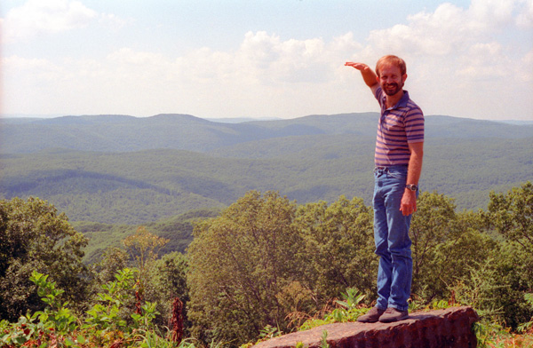
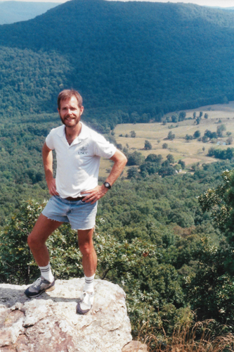
 At the Buffalo River Canyon Overlook |
 At the Buffalo River Canyon Overlook |
I know you probably can't read the sign behind me; here is what it said:
"The summit of Mt. Judea in the Boston range of the Ozarks is 2169 feet above sea level. The Buffalo River flows from West to East 1414 feet below this point- making this the deepest canyon in the Ozarks. It is also the largest- lost in this canyon are the finest canoe waters in wilderness America. Missouri is visible 40 miles due North- West to East is 50 miles- area- 1.3 million acres. An Act of Congress in 1972 preserved the Buffalo River for all time." |
(I guess I was chewing on my lip thinking of that phrase "for all time," and recalling that same phrase, or something like it, was used in the Indian treaties of the 1800s. It didn't mean much then; I assume it means more now.
We crossed the Buffalo River later in the afternoon, and decided to go across on Route 74 towards Lost Valley. Lost Valley and Cave Mountain are next to each other, and Fred wanted to hike up to the Valley and also go into the cave, both of which he had done before. Since it was late in the day (this being Thursday, we decided to do the cave first and save the valley for the next day.
|
Fred had been to the cave before; he had been here himself and he had brought Prudence. So this was his second or third visit. When we got to the small parking area, we were kind of surprised that there was just one other car here, so we thought that even if we didn't have the cave to ourselves, at least we wouldn't be falling over other people.
As luck would have it, no sooner had we got our flashlights and headlamps out and locked up the car than the people in that other car came down the trail from the cave. So it would be a "private viewing" after all.
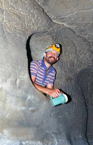
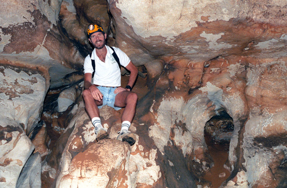
The entrance is fairly small and, once inside, you can walk upright all the way to the back of the cave, which I estimate was between an eighth and a quarter of a mile. There is one path that leads to a twenty-foot drop-off, which can be negotiated if you have the proper ropes, but we didn't. We settled for hiking back to the end of the cave. There was a lot of interesting stuff, including this hole in the wall. You could go back around the wall and stick your head out the hole, which is what Fred is doing here. Fred let me borrow his flash attachment, which worked sometimes and didn't work others.
Cave Mountain Cave is entirely unescorted. The Cave is open all during the Summer, and a locked gate closes it off after the season. The Cave is not a particularly deep or dangerous one, so escorts are not really needed, but there is a board outside the entrance to the cave that stresses keeping your eyes open, not caving alone, safety measures, and so on.
We simply wandered around in the cave for an hour or more. It was cool and pleasant in the cave, and we encountered lots of neat features- although no stalagtites and stalagmites that you might have thought would be here.
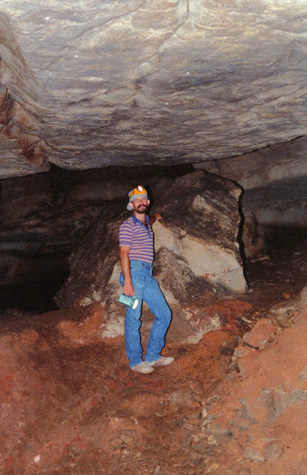 In Cave Mountain Cave |
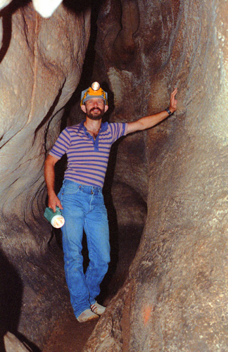
(Picture at left) This shot of Fred shows the typical height of the ceiling. There are a few places where you have to duck down, but basically you have five or six feet at the lowest places. There is a room in the back that opens to a ceiling that must be forty to sixty feet high.
(Picture at right) |
 In Cave Mountain Cave |
The formations are not spectacular, as they are in Carlsbad, for example. If they were, the cave would undoubtedly be escorted. We did find some very small formations, but most of them have either been broken, or never grew in the first place. Inside just looks like a pile of rocks.
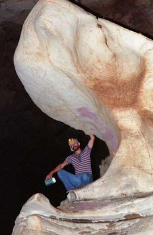 Fred in Cave Mountain Cave |
(Picture at left) Going a little further back into the cave, we came upon a number of interesting formations. Of course, we couldn't see any of them were it not for the flashlights and headlamps we had. This particular formation reminded me of the mouth of a large whale, with Fred sitting in the open jaws. The flash does a right good job of illumination.
(Picture at right) |
 In Cave Mountain Cave |
There is not much debris on the floor, probably because this is an unguided tour area and people are not prevented from picking up souvenirs. Nor are there many formations, this both because the cave is relatively new and also because of the souvenir hunting that is done.
 Me in Cave Mountain Cave Good we had a flash; it was pitch black here. It looks as if there are three tunnels that an explorer might take, and one can imagine each of them leading in a different direction. (Each is only about ten or fifteen feet long and they end at the same place.) I imagine that they are three channels that the water than once ran through this part of the cave carved. |
 Me in Cave Mountain Cave A little ways from where the last picture was taken, Fred wanted me to sit atop this rock outcropping. You will note that the rock seems either reddish or white. The reddish portions are the actual color of the rock, and the whitish portions seem to be some sort of lichen that can grow in the dark. These colors were common throughout the cave. |
The floor of the cave is rock in most places, but in some, like this one, the floor has a fair amount of crushed material on it. This material is mixed with some amount of bat guano; there are still bats that use this cave. In this part of the cave, there is a good deal of mud on the floor of the cave, since there is some dripping water here. It is quite slippery, and your shoes quickly get quite caked with it. The mud is sticky partly because there is also an element of bat droppings added to the fine sand that litters this portion of the cave floor. What looks like a pile of dirt behind me is actually solid rock, although it is covered with this muddy stuff. The cave was certainly cooler than the outside. It was about 95 degrees outside but only about 75 degrees inside the cave. Back in the very back it was chillier still.
|
|
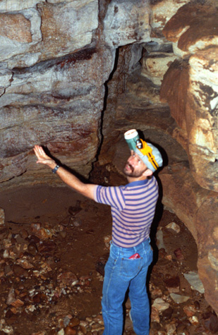
The water doesn't show up in the picture of course, since the drips are infrequent. I was shining my light up into the hole, and feeling the wet surface of the rocks around where the drip was. On the floor below the hole there was a small pool of water, and the sound of dripping was quite noticeable as we approached.
After exploring all the areas of the cave that we could reach without equipment, we went back to the entrance. As we got close to it, we turned our lights off and let our eyes adjust to the darkness until we could see just the faintest glow of light from the outside. Then we proceeded slowly without lights, trying to imagine what it might be like to have to go through a cave like this one in the dark.
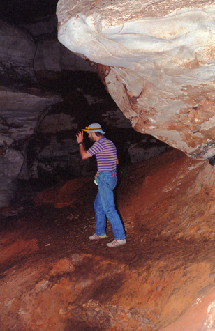
 Fred in the Entrance to Cave Mountain Cave Outside it was late afternoon, and the sun had gone behind Cave Mountain itself, lending a surreal quality to the light coming in. You can see that vegetation can only grow so far into the cave before there is not enough light to support it. Coming down into the cave, those moss-covered rocks are very slippery, and each of us slipped a couple of times before we got our "cave legs". |
 Fred in Front of Cave Mountain Cave I should have wiped off the camera lens; because the camera had gotten cold in the cave, the humid air caused the condensation that made the picture fuzzy. |
It was fun going into the cave, all the more so because the "tour" was unguided. It is also good when you do something like this with someone who has done it before. Another factor that made it pleasant was being able to spend an hour or more in relative cool temperatures, although one feels distinctly clammy coming out.
|
In Harrison, we found a nice, new Comfort Inn that was quite reasonable. We checked in and relaxed for a while, and then, on the recommendation of the desk clerk, went out for some barbecue. The restaurant was OK, but it wasn't the Carolina barbecue that I am used to.
There was, however, another Baskin-Robbins in Harrison, so we added that one to my list.
We returned to the motel, walked around Harrison for a bit, and then did some planning for what we might try to see tomorrow. Then it was time to turn in.
You can use the links below to continue to another page for our Arkansas trip or to return to the trip index so you can continue though the photo album.
|
July 23, 1993: Lost Valley and the Buffalo River |
|
Return to the Arkansas Trip Index |