|
July 24, 1993: Eureka Springs and Hurricane Caverns |
|
July 22, 1993: Hot Springs, the Ouachita National Forest and Cave Mountain Cave |
|
Return to the Arkansas Trip Index |
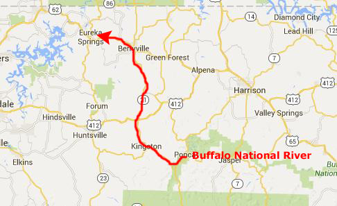
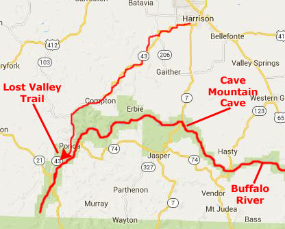
The next day, we drove back down to the Buffalo River area to go hiking on the Lost Valley trail and to see more of the river itself.
The Lost Valley Trail
 |
 |
Fred recalled that when he was here before the ranger house was open to visitors, but it didn't seem to be so this time. We shared a piece of fruit and then started out hiking.
|
With good reason, this is the most popular hiking trail in the Buffalo National River, as well as the state of Arkansas. It is said that there is never a bad time to hike Lost Valley- it's as beautiful in winter as it is in springtime.
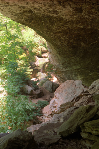
Geologists tell us that the box canyon which forms Lost Valley was probably once all underground and that the large bluff shelter (Cobb Cave) and small underground cave are remnants of that single underground cavern.
The trail is replete with wildflowers and medicinal plants, and features a wide variety of species, including bloodroot, crested iris, columbine, mayapple, comfrey and Ozark trillium, just to name a few.
Our little trail guide also said that the various waterfalls in Lost Valley run best after a rain, but it has not rained a lot here for some weeks. But, the guidebook noted that even in drier summer months the trail is very pretty and merits the 2 hours it takes to complete the hike.
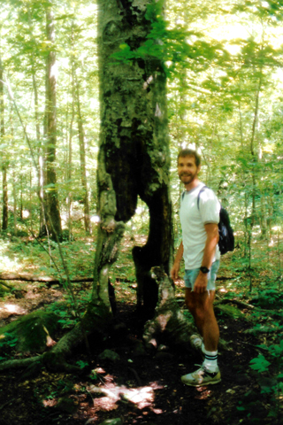
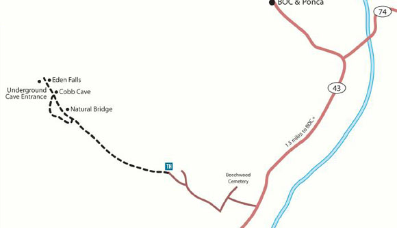
We hiked about three-quarters of a mile before we reached the first of the notable features of the Lost Valley Trail- the Natural Bridge. Fred had hiked this trail once before with his friend Prudence, but one thing about Fred is that if he does something that he likes he doesn't mind doing it again. I am much the same way. But he knew the major formations that we would see along the way, and one of them was formation, which was actually a natural bridge, formed by a small creek that has cut a hole right through the rock bluff.
|
|
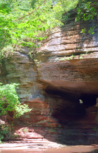
You can see again the channel that the water has cut through the rock. We got off the actual trail here to walk over to the natural bridge; you can walk all around and over it. The trail itself winds around the whole rock out of the picture to the right and you can clamber up the face of the rock here and go through the channel cut by the water.
It is actually quite wide, and you can stand up most of the way through it. In this last picture, I wanted to try to get more of the detail of the rock face. It is very hard to judge an exposure when you want to see a dark area well but there is also bright light elsewhere in the picture. I think this was about as good a compromise as I could get.
|
|
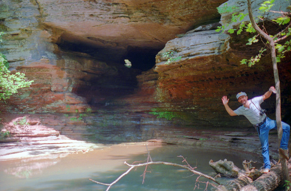
The pool is back around the channel to the right in the picture; you can't see much glow from the outside from that direction because it is washed out by the flash that Fred was using. There was just a very small amount of water flowing through here, mostly because the weather has been just as dry here as it has been in Dallas and Austin lately.
It was really fun walking underneath the natural bridge, although you don't get the "bridge" impression much since the channel is so narrow and the rock above us is so massive. We have seen "natural bridges" at a number of places out west, and at those sites the mass of the bridge part is much less, and the opening beneath it much larger.
|
|
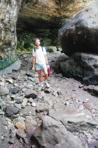
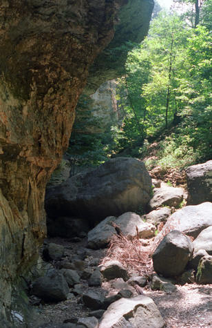
Going through the tunnel underneath the natural bridge was actually a short-cut on the Lost Valley Trail, as the actual trail circled around the rock, so when we emerged from the tunnel and climbed a short slope, we were back on the trail and heading in the right direction- towards Cobb Cave. To get there, you can either go back to the trail and keep hiking up or you can do what we did, which was to climb over the large rocks and trees that litter the course of the water as it flows down the mountain beside the trail. There wasn't much water, and at this point it had gone underground temporarily, so the hiking was easy. Cobb Cave is actually a giant bluff shelter and gets its name from the Native American (likely the Osage) corn cobs that were found at the site by a University of Arkansas archeology team.
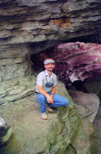
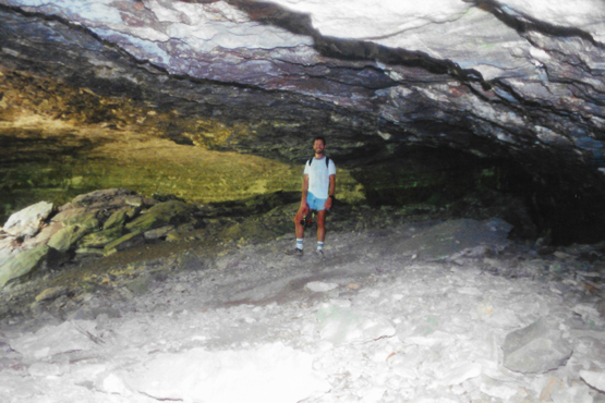 Me in the Back of Cobb Cave I am back about as far as I can go under the overhang and still stand up. There is lots of sand and small rocks on the floor; the guidebook says that this rock has been used many times as a shelter, both by Native Americans and settlers in the area. Small pieces of rock are continually falling from the ceiling, and the floor is littered with them. |
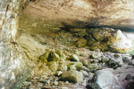 The Cobb Cave Overhang Here you can get an idea of just how big this overhang really is. I am sitting on a rock; the overhang wall is another hundred feet behind me, so it has to be a couple hundred feet wide. The overhang is fairly level when you get up behind those rocks in the background and to my left. This formation resembled nothing more than huge natural bandshell. |
This area up here cannot have been cut by water. The water would have to have been very, very deep, and there are no signs that the creek up which we are hiking was ever that deep or had that much water in it. There must simply have been a fissure in the rock that allowed small pieces of the ceiling to break off. These rolled down the floor to the actual stream bed where they might have been carried off in flood waters. This left more room for other pieces to fall. The larger pieces simply stayed where they were, although as the floor of the overhang was slowly eroded, perhaps some of them toppled and rolled down further towards the creek. The whole process must have taken ages.
 The Cobb Cave Overhang |
(Picture at left) This picture looks up-trail from the overhang, and gives you a good idea as to the curvature of the ceiling. It is taken from about the same place as I was sitting in the picture before. The hiking was a lot of fun here, and not too strenuous.
(Picture at right) |
 The Back of Cobb Cave |
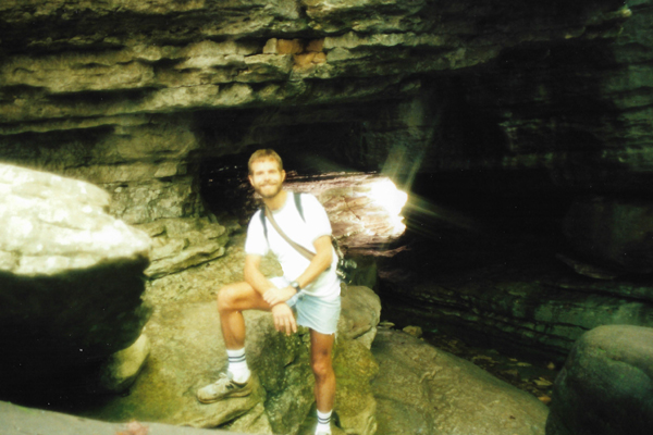
I started out of the back of the overhang, and Fred had already gotten back out on the trail. I asked him to stop there so I could take a picture from well inside the overhang; you can see that picture of Fred on the trail by clicking on that link. As you can see, the trail runs right by the overhang at this point; there is still quite a bit of cave floor behind me. The creek bed runs right along at Fred's feet, but you can see that there is no water in it at the moment. You can also see that some of the larger boulders have rolled down into that creek bed.
We continued on along the Lost Valley Trail to its end point at Eden Cave. We found the cave easily enough; it was marked by the small waterfall outside- a waterfall created by the stream that runs through the cave.
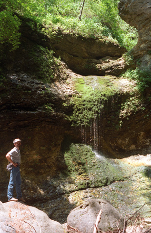 Eden Falls |
(Picture at left) We found this water feature as we hiked up the creek bed; there is a small amount of water there is is running down the rock face. You can clearly see the water running down the channel and then over the rock face down to the small pool below. A lot of algae and moss has grown on the rock face; it gives the effect of a small hanging garden.
(Picture at right) |
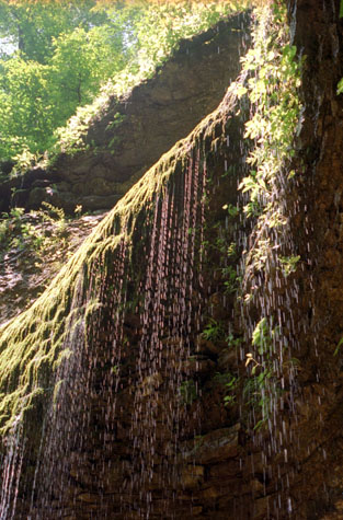 Eden Falls |
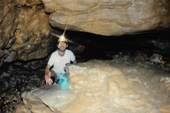
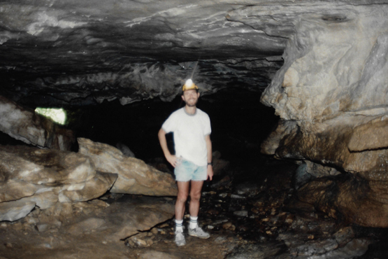
As I have mentioned before, Fred is a sucker for waterfalls and other water features; I think if I could afford it I would have Disney do his acreage in Van Alstyne, putting in just such a waterfall. Here there was another overhang, but also the entrance to the 150-foot-long Eden Cave. We had to crawl as we followed the narrow corridor back to the waterfall room. Taller folks will need to stoop here and there in the corridor.
 Outside Eden Cave |
(Picture at left) Here is the creek bed just outside Eden Cave; it is pretty dry right now.
(Picture at right) |
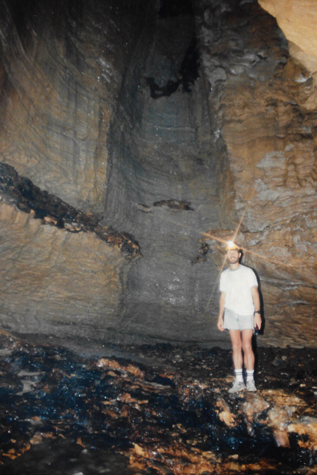 The Waterfall Room in Eden Cave |
Our little trail guide suggested turning off our flashlights here to appreciate just how dark a cave can be, something we have done in other caves before. We went back out of the cave the way we came, and returned down the trail towards the car. On the way, we stopped again at the natural bridge to walk through the tunnel again:
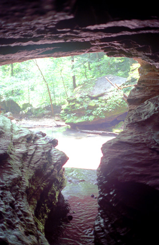
 Inside the Natural Bridge Tunnel This picture gives some idea of how low the ceiling actually is. You could walk in the groove made by the water, so it was not so difficult, but there are places that are not that high. |
 Inside the Natural Bridge Tunnel The water channel is at my feet in front of me. I assume lots of hikers make the trip through the tunnel; it was very interesting. |
We spent well over 2 hours on this trail, taking our time to see as much as we could.
The Buffalo National River
|
So we put on some shoes that we could get wet (because you have to ford the river in a couple of places according to the map) and started out. We went about a half a mile before the trail began to give out as far as hiking was concerned- it was really just a horse trail so it was not wide enough that you could walk along and not have to fight your way through weeds and grass.
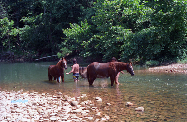
It was also very hot and the trail not very pretty, so we decided that this trail wasn't for us and we returned to the starting point. Then what we did was just walk along (and in) the river for a ways. Right near the trailhead were the same riders washing down their horses in the river. The horses looked like they were enjoying the bath. You can see that the river is not very deep here.
It was certainly nice walking along the river here; out in the open where there was a breeze it was a lot better than on the overgrown trail that we had tried. It was also neat that we were wearing shoes we could get wet; this allowed us to cool off by walking in the water when we wished.
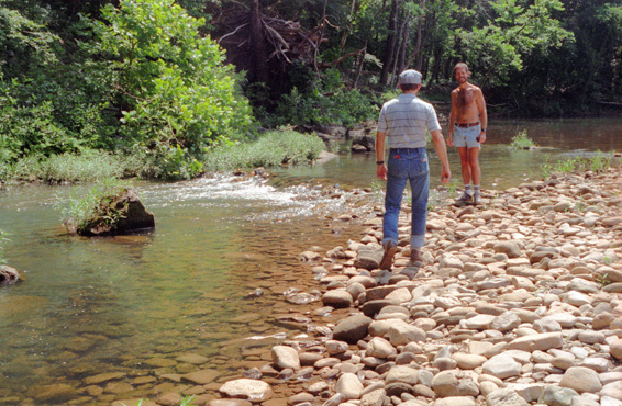
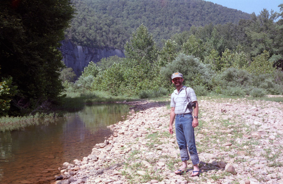
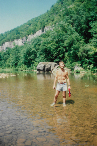 Me Standing in the Buffalo River |
(Picture at left) The water is not very deep over most of the surface of the river; there is just one point about ten feet across where the water is deeper than your waist, but I am not sure if it is even deeper since you cannot see the bottom. We are walking downstream in the direction of that large rock in the background.
(Picture at right) |
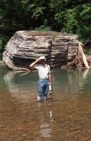 Fred Standing in the Buffalo River |
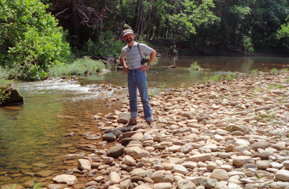 Fred Beside the Buffalo River We hiked a bit further, and then I took this picture looking back along the way we had come, of Fred walking on the rocks and stones that form the river edge. I imagine that during the rainy season, this entire area is covered to a depth of quite a few feet. |
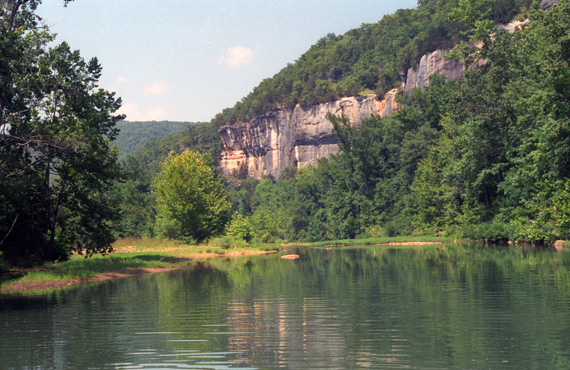
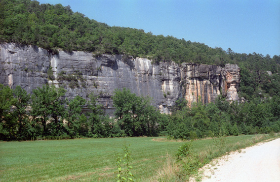
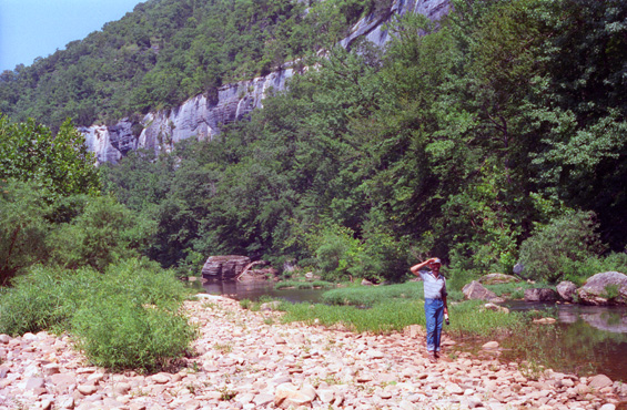 The Bluffs of the Buffalo River Here you get a good idea of the width of the river, which is not much at this time of year, but you can also see how wide it must be when there is a lot of water. |
Obviously, the entire rocky area that you see was laid down by the river, and the water would have to be fairly deep to carry rocks that size along. So I deduce that in flood, the river is at least as deep as Fred is tall. You can also see the curvature of the bluffs that have been carved out by the river over time, as it makes this curve on its trip downstream. The sun was quite bright, and Fred is shading his eyes.
 Timing is Everything Either Fred misjudged the time of the delay, or something malfunctioned on his camera, because he didn't have time to get to where I was standing before the picture got taken. I had my shirt off to keep cool, but Fred didn't, and he was really sweating through it. |
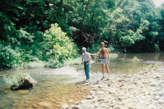 Fred and I in the Buffalo River Now Fred has been successful in getting into the picture with me. Fred and I are really about the same size, although this picture makes it look as if I am a good deal larger! |
We continued walking along the river in the very, very warm afternoon. The coolness of the water on our feet and the breeze in the air made it pretty neat, though.
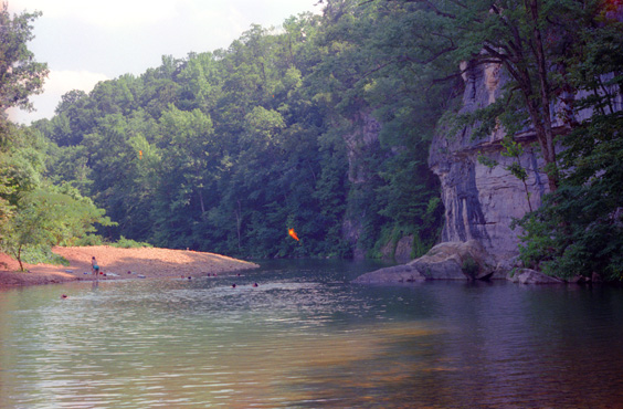
 A Tranquil Stretch of the Buffalo River After a while, the rocky portion of the riverbed ends, and the next stretch of the river looks like this. Note the bluffs formed by the water action. |
 The Buffalo National River I got out into the middle of the river, and then looked downstream to where Fred was standing on the shore looking at the opposite side of the river. |
This area of Arkansas is very pretty; everything is heavily wooded, and the whole area is very much on the remote side. When we got back to the car, we drove about a mile further down the river to another spot where there were picnic tables and such and had a snack. Then we walked through the small forest to the edge of the river again to do some more walking.
 In the Buffalo National River Walking through the river here there were lots of these rock/gravel/sand bars in the river. |
 The Bluffs Along the Buffalo River I got this picture of the bluffs along the river. It is hard for me to imagine how a river as small as the Buffalo, and flowing as slowly as it does, could have carved these bluffs, but carve them it did. |
After finishing our hike along the Buffalo River, Fred and I headed further North and West to the resort town of Eureka Springs, Arkansas.
|
We went out to drive around, and went by a theater in which a country music show (the Arkansas Country Hoedown) was playing. Fred had been to this kind of thing before, and he wanted to try it again, so we purchased tickets for that evening's show. The seats were reserved, so we didn't have to wait around to get good ones; we went to a restaurant to get dinner. It was one of those Golden Corral affairs, and it was good and filling, if not gourmet.
Then we went to the show which was fun, if a bit hokey. This whole area of Arkansas and the adjoining area of Southern Missouri (particularly Branson) is noted for this kind of touristy country flavor. I think it feeds on itself; most of the people who go are actually country people who end up looking at something of a parody of themselves. There is a lot of good-natured joking and such, and the music is OK, but I felt that country itself was being a bit insulted by the show. Not everyone in the country is a hick; although I guess I don't have much room to talk since, although I like Country/Western music, I am not really by background a country person.
After the show, we went down into the town of Eureka Springs. We began by stopping at a country store for some ice cream, and then we went down into the center of town to walk around. Most everything was closed, but we did find an "alternative" bar so we stopped in for a few minutes. Then it was back to the motel for a good night's sleep.
You can use the links below to continue to another page for our Arkansas trip or to return to the trip index so you can continue though the photo album.
|
July 24, 1993: Eureka Springs and Hurricane Caverns |
|
July 22, 1993: Hot Springs, the Ouachita National Forest and Cave Mountain Cave |
|
Return to the Arkansas Trip Index |