|
October 27, 1995: Fall Trip to Arkansas: Day Two |
|
Return to the Index for Our Fall Trip to Arkansas |
The first day of our Arkansas trip wasn't really a day at all; it was just getting to Arkansas after Fred finished work on a Wednesday evening.
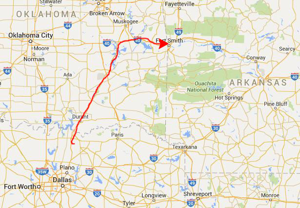
Getting to Fort Smith, Arkansas
|
We both had plenty to eat, of course, since Golden Corral is a buffet. We then continued on up the highway to Atoka, Oklahoma. There, US Highway 75 splits off, angling up to the northeast, and we could have gone that way, but the faster route is to take US Highway 69 through McAlester and on up to Interstate 40.
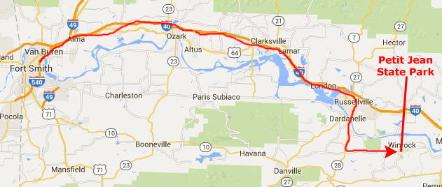
From there, we headed east on the interstate, arriving in Fort Smith at about midnight.
We had made reservations at an Econo Lodge in Fort Smith, but found that it was all the way downtown, rather than out by the interstate, so that took a bit more time. But we finally got settled in for our last night in a real bed until we returned.
Getting to Petit Jean State Park
|
Petit Jean State Park is not only one of Arkansas' finest state park facilities, it was actually Arkansas's first state park. It lies in a unique area between the Ozark and Ouachita Mountain ranges in west-central Arkansas. Situated upon beautiful Petit Jean Mountain, the part encompasses 3471 acres of rare natural beauty. In this lovely mountain setting are an abundance of unmarred woods, ravines, streams, springs, spectacular views and interesting geological formations preserved almost as French explorers found them 300 years ago.
Petit Jean Mountain has a fascinating history, one that dates back well before the idea for the establishment of a park system began, even before pioneers settled here, when tribes of Native Americans visited the area. Within Petit Jean State Park is one of the largest bluff shelters in the state. Accessed via Rock House Cave Trail, this bluff shelter was home to Native Americans well over a thousand years ago. These bluff dwelling Native Americans used the shelter as their house, and lived as nomads, hunters, and gatherers. They hunted with spears, for they had yet to invent the bow and arrow. And, they left behind evidence of their existence. Today, evidence can be seen in pictographs located high on the back wall of the cave. These pictographs were painted using minerals from the rocks in the area, telling stories important to those who created them.
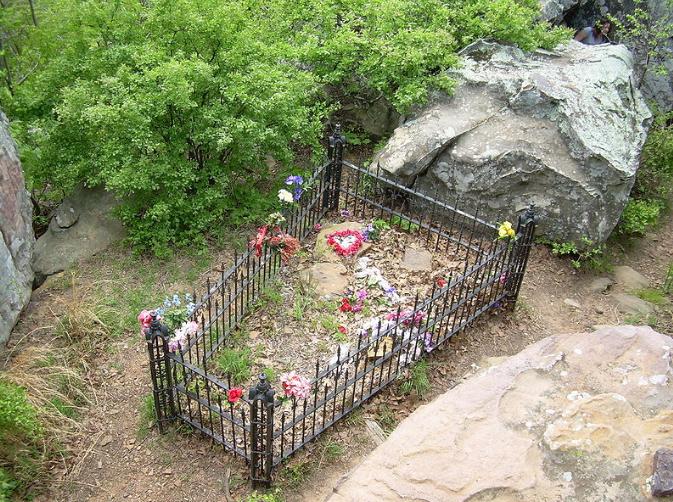
The Legend of Petit Jean
|
Crossing the ocean, the ship made its way to the foot of the mountain via the Mississippi River and the Arkansas River. The Native Americans were friendly, and Chavet, Petit Jean, and the sailors spent the summer atop the mountain, eventually readying and boarding the ship for a departure back to France. But that night, Petit Jean became ill with a sickness that was strange to Chavet and his sailors. Her condition was so grave at daylight that the departure was delayed. During the illness, Petit Jean's identity was, of course, discovered. The girl confessed her deception to Chavet and begged his forgiveness. She requested that if she died, she be buried atop the mountain, at a spot overlooking the river below. When she died, the Indians made a stretcher out of deerskins and bore her up the mountain.
Many years later a low mound of earth was found at the point is now called Petit Jean's Grave. Her death, and the legend that followed, is said to give the mountain and the overlook an enchanting quality that draws visitors back again, and again.
The Park is Established
|
Dr. Hardison arranged a meeting with Stephen Mather (for whom Mather Lodge was named), director of the National Park Service, at which he showed photographs and answered questions. Mather explained that he could not recommend the area as a National Park because it was too small to justify the cost of development and administration and, as beautiful as it was, it was probably not unique in the nation. He suggested, however, that Dr. Hardison undertake to bring about its acceptance by the Arkansas Legislature as a state park.
The Board of the lumber company, having approved offering the land for a National Park, had to meet to decided whether to offer it for a State Park. While this was happening, eight nearby landowners offered to donate 80 acres of land for a State Park; this land included Cedar Falls and a portion of Cedar Creek Canyon. The Governor eventually signed a bill from the Legislature to establish this 80-acre park. And, eventually, Hardison was successful in getting the lumber company Board to amend their donation and the Seven Hollows tract became part of the State Park as well. Part of the bill suggested the name Petit Jean State Park, and that was the name that was finally approved.
|
Being a company of World War I veterans, most of the men were older, with experience in construction work. The CCC worked at Petit Jean from 1933 to 1938. The first project was living quarters for the camp. Soon after, construction of Mather Lodge and the cabins began. Work was also started on the construction of a native stone dam for the formation of Lake Bailey. Once the lake of approximately 100 acres was complete, a water tower was constructed for Mather Lodge and the cabins. During the CCC's tenure at Petit Jean, they made great strides in road building, trail building, and the construction of impressive structures still enjoyed in the park today, including Mather Lodge, the pavilions, and the Davies Bridge over Cedar Creek to Red Bluff Drive.
The work of the CCC at Petit Jean has been recognized as an outstanding example of CCC work in Arkansas. Petit Jean has three National Historic Districts including over 80 buildings, structures, trails, and bridges. Mather Lodge is the only CCC-built lodge in Arkansas.
The Park and Our Campsite
|
We surveyed a good many campsites, and eventually found an excellent one, high up on the mountainside, secluded and with a number of good spots in the trees where we could pitch the tent. We left our picnic cooler on the table to reserve the site, and went off to hike the Seven Hollows Trail.
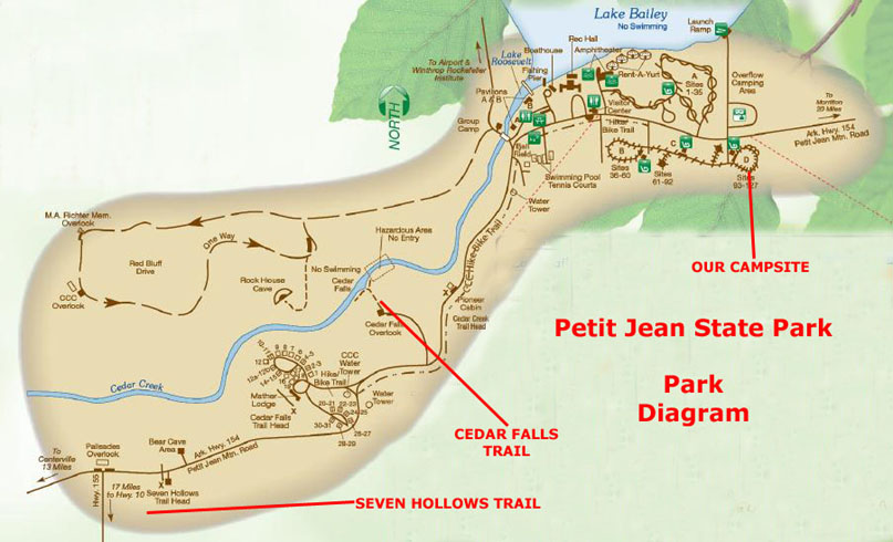
Before we talk about that hike, you might refer to the park map at right where you can see how the park is laid out, and where the major things we did were located in relation to each other. In addition to the two major hikes at Seven Hollows and Cedar Falls, we stopped at many overlooks and at Mather Lodge.
As you can see, the Seven Hollows area is located at the west end of the park, south of highway 154 and east of Arkansas Highway 155.
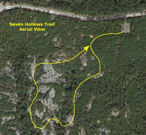
Hiking the Seven Hollows Trail
|
In April of 1907, executives of the Fort Smith Lumber Company, who owned the Seven Hollows area, recognized that it should be preserved for everyone to enjoy. Under the direction of Dr. T.W. Hardison, resident of the mountain and physician for the lumber camp, a request was put to the National Park Service to study the area for potential park designation.
When that proved unworkable, the executives considered the opinion of Stephen Mather, director of the National Park Service, who suggested that the area be set aside as a state park instead. Petit Jean State Park had actually just been established on an 80-acre grant from a group of local landowners when the lumber company executives approved a plan to donate the Seven Hollows area to the new park.
Through much work on the part of Dr. Hardison, the inclusion of Seven Hollows into Arkansas�s premier state park became a reality in 1923. The Seven Hollows National Recreation Trail now allows visitors to experience some of the land that led to the creation of Petit Jean State Park.
At the parking area, we took one of the trail brochures that were available to guide us on our five-mile hike through the Seven Hollows area. Some of the information for the descriptions of the pictures we took came from that brochure.
This trail was a bit different from some others we've been on in that there was not always an established or obvious trail to follow. Here, the practice for marking the trail involved blazes in light blue painted on trees about 5 feet above ground level. The paint doesn't hurt the tree and the light blue color stood out against the browns of the cliffs and the green of the canopy above. In almost every case, if you stood beside one blaze you could see the next one clearly.
|
|
It was the unspoiled beauty of Seven Hollows that inspired the establishment of Petit Jean as Arkansas' first State Park. When the lumber company executives first announced their plans for a National Park, local landowners moved ahead to establish a state park. Even though the National Park was never created, had the executives not announced their plans when they did, it is entirely possible that the landowners would not have taken their own actions. Eventually, the Seven Hollows area became part of this, the state's first state park.
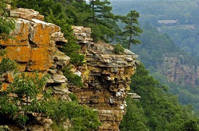
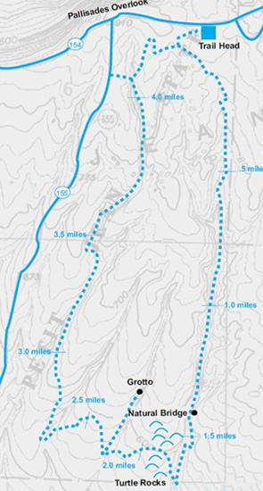
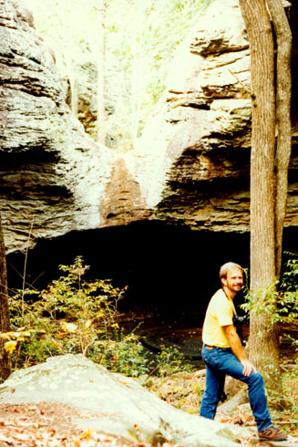
This Seven Hollows National Recreation Trail is one of the feature attractions of this Park. Even just a few minutes into it, we could see that the hike was going to be a beautiful one, and was heavily forested most of the way. The hiking was relatively easy, and there were many formations like this one along the way. Our first objective is the Natural Bridge, about eight-tenths of a mile from the start.
As we walked, we noticed how the sandstone bluffs began to rise on our right as you enter the first hollow. As the hollow narrowed, the bluffs to the left came into view. All of these hollows have been carved out by streams. These small streams still exist in the center of the hollows, slowly deepening the valleys. At times of heavy rainfall these streams can flood quickly making parts of the trail impassable.
When we passed mile marker 1, our brochure had us look out for the natural bridge, and soon we were upon it.
 |
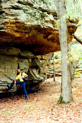
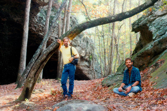
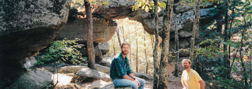
(Picture at left) Here are Fred and I at the Natural Bridge; as usual, Fred brought his tripod for pictures like this one. Despite its name, Seven Hollows Trail passes through only four of the most interesting hollows. Carved by streams that flowed through them for millions of years, each hollow has its own natural beauty. Hartshorne Sandstone is the foundation of the Seven Hollows landscape. This sandstone contains hard iron deposits which have caused it to weather at varying rates and created a wide variety of colors and patterns on the rock faces.
(Picture at right)
|
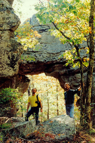 |
Although the brochure said that the natural bridge was easy to miss, we had no trouble spotting it. The sandstone bridge is thought to have once completely spanned the hollow, but the larger parts of the arch have worn away; we could see some of the collapsed sections of the bridge down in the hollow. The day was warm, but not hot, so the hiking was pretty enjoyable as far as comfort was concerned, although there were a few places strenuous enough to work up a sweat.
|
|
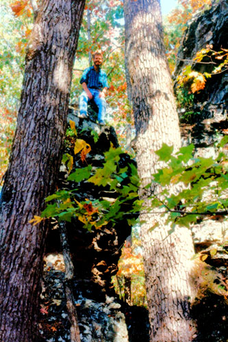
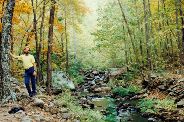
The sandstone bluffs rise along either side of the trail in the first hollow, which is approximately one and one-half miles in length. The rock formations here were somewhat different in shape from those in the other hollows. Here, I have climbed up above the trail to look down on Fred. I enjoy this kind of scrambling climbing very much; I draw the line at climbing that requires special equipment. Here, the rocks offered many handholds and usually an easy way up. Unless I got really stupid, I was pretty much guaranteed not to get in trouble. I spent about as much time off the trail as on it.
Fred had his panoramic camera along, and he set up the tripod to take a nice picture of the two of us:
 |
|
Leaving the first hollow, we passed through a sandstone glade. The contrast in moisture and temperature between the glade and hollow creates two distinct environments- including different plant life. Also along this glade we begin crossing one of many sections of trail where rock formations created by chemicals in rainwater have slowly eaten away veins in the rock and left forms that look like the shells of giant turtles.
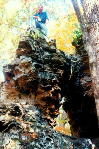
At right you can see me on top of one of the sandstone formations near mile marker 2 on the Seven Hollows Trail. This is a good example of the kind of rock formations that there were along the trail, and you can see that the distance up to the top of the formations is not great, and also that the rocks themselves offer lots of handholds and easy climbing. Fred was kind enough to keep track photographically of my excursions off the trail.
More past the mile marker, we went through a forest of smaller trees- mostly post oak and mockernut hickory. The soil was dry and relatively poor here, but the guide brochure said that in May and June many varieties of colorful wildflowers bloom here. Purple coneflowers, tall flowers with drooping lavender petals, may be present.
|
At left is a picture Fred here at the Grotto. We left the first hollow, and crossed a sandstone glade, where the contrast in moisture and temperature between the glade and the hollow created two distinct environments. We entered a forest of smaller trees- mostly post oak and mockernut hickory. There are lots of wildflowers here earlier in the year, but by now they had disappeared.
At the bottom of the second hollow (through which the trail does not go), we continued across a creek bed. There is a short side trail that follows the creek to a spot called "The Grotto." There is little water flowing here, although at other times of the year there is probably more, so the pool below the waterfall is stagnant.
I'm not quite sure how the water made the opening in the cliff, unless there had been a pool above the slowly rose until the first low point in the rock was found. From there, the erosion power of the water could slowly have carved the opening you see here. This shelter supports many types of wildlife, and was once inhabited by Indians.
Taking the advice of the guidebook, we took a few minutes to look around for animal tracks in the soft sand at the base of the falls. The guidebook had some samples we could look for, and we found some of them. Then we backtracked to the main trail to follow the signs and blazes out of the hollow.
|
The last 1.5 miles of the trail contained some of the prettiest landscape in the entire park. As we passed into the fourth hollow, the terrain became level and it is easier to walk quietly down the trail. This, according to the brochure, was a good spot to watch for wildlife. Some of the most common birds found in this area are eastern phoebe, tufted titmouse, Carolina wren, summer tanager and bluejays and a variety of different woodpeckers. We heard owls off in the forest and we saw a number of what looked like birds' nests constructed of mud up under the overhangs.
As we strolled up this quiet, peaceful hollow it was easy to imagine being the first to see this incredibly beautiful area. The creek and towering sandstone bluffs set this hollow apart from all the others. The last section of this hollow contained the remains of an illegal activity once common in the area- bootlegging. Some of the more enterprising inhabitants of the area took advantage of the isolated hollows and their access to cool water to manufacture moonshine whisky, especially during prohibition. If we had visited this area in the late 1920s, we may have been confronted by an armed guard acting as a lookout.
Close to the end of this last hollow the Boy Scout Trail leaves the Seven Hollows Trail and begins down the mountain. The blazes for this trail are white. We Continued following the light blue blazes to return to the trailhead and where we had left the car.
Hiking the Cedar Creek Trail
|
The trail began at the "pioneer cabin" constructed in 1845 by John Walker, the first settler on Petit Jean Mountain. It was moved here close to Mather Lodge from its original location, now under the waters of Lake Bailey. Walker lived in it for three years until Own West purchased the cabin and lived in it until 1877. It was then bought by Walker Carlock, who rebuilt it and moved it to where Campground D is now. Additions to the cabin included a screened-in kitchen in the back and small enclosed sleeping rooms opposite the fireplace. A blacksmith shop was also built at the site. The Carlock family sold the cabin and property to the state park in 1933, and the CCC moved the original portion of the Pioneer cabin to where it sits today. The cabin sits at a monument to honor the pioneer spirit.
The trail we were walking on was built using little or no machinery. The stone steps from the Pioneer Cabin down to the switchbacks are good examples of Civilian Conservation Corps work. Using only hand tools and terms of mules, these steps were cut and laid by hard-working men earning a daily wage of one dollar. We continued along the trail, following the stream, until we came to the base of Cedar Creek Falls.
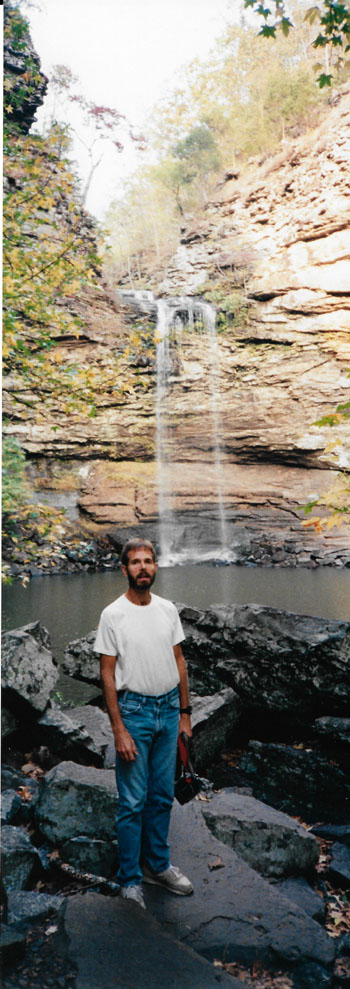
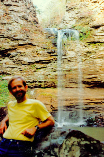 Fred at Cedar Creek Falls |
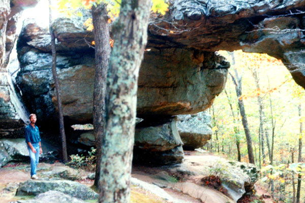
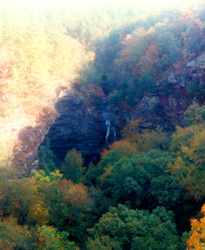
(Picture at left) This picture is deceptive. I would estimate that it is an eighth of a mile from where Fred is standing to the falls. And I would estimate that the falls are somewhere around 100 feet high. It was quite warm and humid down here, although that may be the result of the quick pace we had been keeping on the walk down here. One can climb around the pool to the left in the picture and actually get up behind the falls themselves. This area was very pretty, and the rock cliffs actually rose another fifty feet or so above the top of the actual waterfall. There is another trail that leads to an overlook on top of those cliffs.
(Picture at right)
|
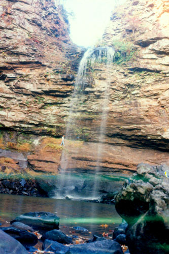 Me Behind Cedar Creek Falls |
We encountered one or two springs (actually seeps) along the trail. Some had iron and sulfur deposits around them. Cedar Creek Falls used to be much more dramatic before the stream was dammed to create Lake Bailey. But when there has been a good deal of rain, water is let out of the lake more rapidly, and these falls are much more spectacular.
|
|
After sitting behind the falls for a while, I continued to the other side of the falls, looking for a way up to the overlook, but the cliffs were too steep. So I continued around the edge of the cliff face, finally descending and crossing the creek again to meet up with Fred, who had started back along the trail. I had to be careful as it seemed that one of the more prevalent plants in the area is poison ivy.
The climb back up the trail was as strenuous as I expected and we reached the top a bit winded. After a short rest on some outside chairs at the Lodge, we walked over to the overlook for Cedar Falls from which point the picture at left was taken.
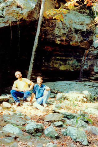
With a bit of time left, we then decided to take a short walk down the Bear Cave Trail, which goes from the Lodge along the roadway back towards the Seven Hollows Trail trailhead. I think Fred expected more of a cave than we got, but it was a nice walk nevertheless, and a good way to cool down. The afternoon light was very poor, though, so I have no pictures from this heavily tree-shaded trail.
As the light was fading, we headed back to the campsite to set up the tent and have dinner.
I Learn a Lesson in Selecting a Tent Site
I awoke again about five-thirty and my feet were quite cold. I just thought they were dangling over the edge of the air mattress, but then I thought that they shouldn't be cold as the sleeping bag is totally enclosed at the bottom. Then I realized that they weren't cold- they were wet. When I pressed my toes down over the edge of the air mattress, I could hear and feel water. I reached over the side of the mattress to feel for my small carryall, and I could feel that the bottom of it, too, was wet. I figured that what was wet would stay wet and that there wasn't much I could do about it now, particularly since the rain had stopped.
An hour or so later, when we both awoke, Fred could also see what had happened. When we got up, we realized that the tent was sitting in a gentle depression in the ground, and the water had simply filled the depression and eventually run over the top of the tarp. Since the bottom of the tent is not waterproof, it had come into the tent and caused everything in contact with the ground to get wet- at least on the bottom.
So the lesson I learned was to always check the slope of a tent site, and make sure that thee is a slope that will carry water away from the tent should it rain. (I learned this lesson well, and in all the camping we have done subsequent to this, we have never had a recurrence of this particular disaster.) When you go to tomorrow's album page, you'll find out what we had to do after we got up.
You can use the links below to continue to another photo album page.
|
October 27, 1995: Fall Trip to Arkansas: Day Two |
|
Return to the Index for Our Fall Trip to Arkansas |