|
October 28, 1995: Fall Trip to Arkansas: Day Three |
|
October 26, 1995: Fall Trip to Arkansas: Day One |
|
Return to the Index for Our Fall Trip to Arkansas |
In the light of morning, we found that there was not a great deal of damage- just the tarp and tent were quite wet, along with some pieces of clothing that I had laid on the bottom of the tent. The water had not gotten into my bag or Fred's, but we knew we'd have to dry everything out before that evening. We talked about our options as we took showers that morning, and decided to ask at the Visitor Center about laundromats nearby where we could dry the stuff.
The Cedar Falls Overlook
|
The overlook is about halfway between the Visitor Center and the park entrance. We parked and walked down the stone trail to the overlook- essentially a stone platform that runs for a hundred feet or so along the top of the cliff. There are railings to prevent the obvious, and there are excellent views of the Falls and the valley.
On our hike yesterday afternoon, we took the trail that leads to the base of the falls that you see here (where I got behind the falls). There is another trail that we didn't take that begins near the Visitor Center and goes along the creek to a point near the top of the falls, but you aren't really able to get close and look down- too dangerous.
We took two more photographs from here at the overlook, and here they are:
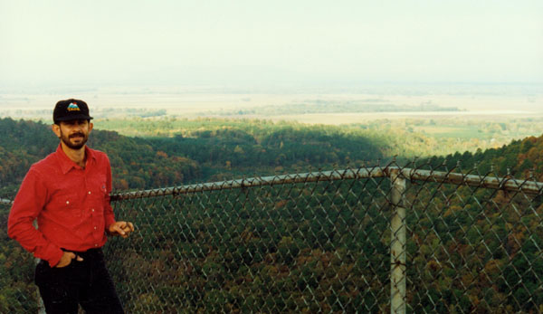
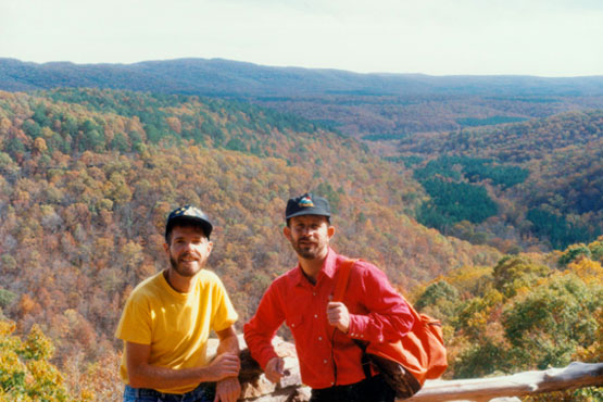
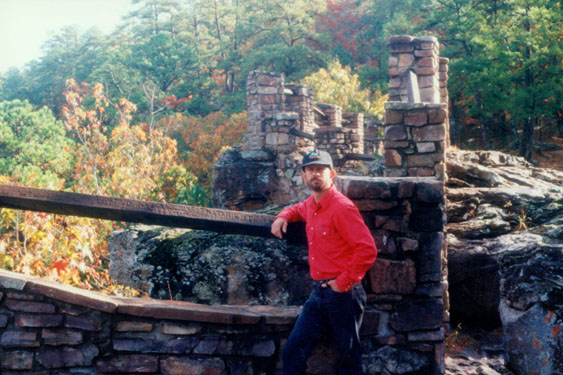 Here's a picture of Fred at the Cedar Falls overlook in Petit Jean State Park, Arkansas. You can see how the overlook is constructed and situated. I think a very good effort was made to have the overlook blend in with the natural scenery- at least they didn't bring in a lot of foreign materials to build it. Using the same stone as the cliffs themselves are composed of was a good idea. This shot looks somewhat northeast and Fred looks quite good here, I think. |
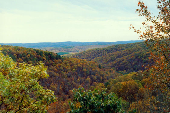 This view looks northwest from the Cedar Falls overlook. There was some overcast this morning, but it was supposed to disappear (and did) by noontime. Even so, the view from here is quite beautiful. I told Fred that it reminded me of the hills of western North Carolina, in the foothills of the Blue Ridge. He's never been there, and perhaps that would be a good hiking trip when we exhaust the West. The Fall color wasn't spectacular, but certainly prettier than it is around Dallas. |
As we were having a look from here, I was thinking about how we would get all our stuff dried out, although Fred didn't seem concerned. Fred is more easy-going about some things than I am. We headed back through Russellville and easily found a laundromat, where we spent the better part of an hour drying everything that had gotten wet- including my wallet. The only thing that went wrong was that the tarp got too hot in the dryer, and melted slightly in a couple of spots- crinkling up as it did so. Everything else was fine though, and the tarp is still more than usuable.
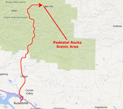
The Pedestal Rocks Trail Near Pelsor, AR
|
Our guidebook said that this area was a great place to explore, and that there were two really good loop trails, each leading to its own scenic area. This was a day-use only area, and offered hiking trails, a picnic site, and a vault toilet. The parking area seemed small, with space for only five or six vehicles. But we were the only ones there when we arrived; these hikes are a bit out of the way and not many people visit. You kind of have to know the hikes are here.
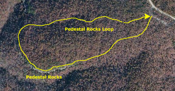 |
Beginning from the parking area, the trail headed into the woods and immediately split. The trail to the right starts the Kings Bluff Loop, while straight ahead the trail forms the Pedestal Rocks Loop. We thought we would do the Pedestal Rocks Loop first, and then too the other if we had time.
|
|
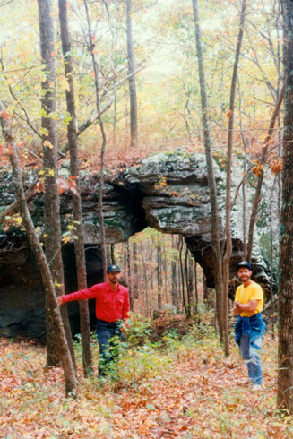
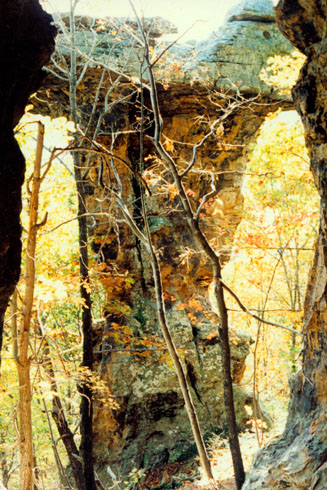
It turned out to be a great hike, and it was fortunate that Fred saw it in his book some time ago and planned to stop. The hike began on some fairly level terrain, with the Fall foliage very much in evidence. As the hike wound through the forest, it passed a number of rocky formations, including this natural bridge. The terrain was much like the Seven Hollows Trail in Petit Jean, although there were not so many opportunities for climbing. It was to offer its own unique attractions, however.
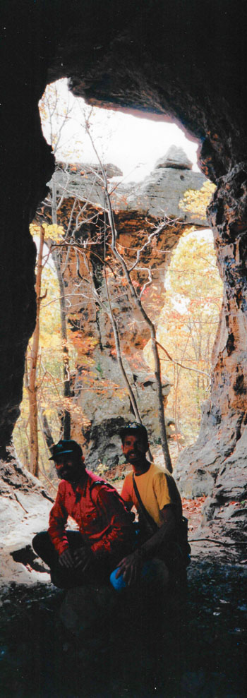
Not far down the trail, Fred found an opportunity for a panoramic picture, and he set up the tripod and had us sit under a rock overhang, looking out to one of the pedestal rocks. The flash did not reach as far as we had hoped, but even so it was a good picture. Since it is so tall (being panoramic), I have put it in the scrollable window at the immediate left.
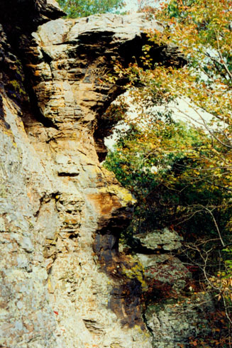
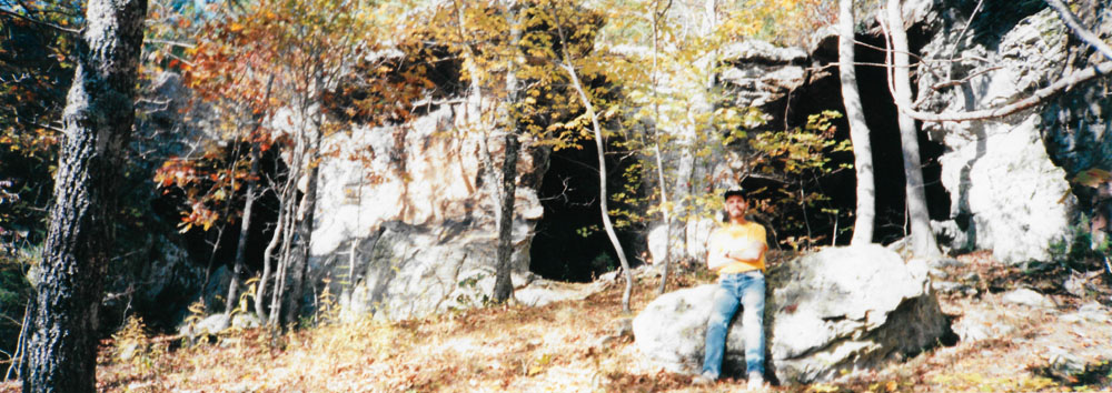
The Pedestal Rocks Loop is 2.2 miles long, and visits the main attraction of this area- Pedestal Rocks. These unique rock formations were formed over eons from water and wind erosion, sculpting some unique "mushroom" shaped columns, as well as the numerous small caves and rock shelters in the sides of the bluff.
This was a great area to learn about and study Arkansas's unique geologic history firsthand. Following the instructions in the hiking guide, we kept straight from the parking area at the first intersection at the trailhead, and then continued another tenth of a mile to a 3-way intersection. Continuing straight on and we were on the outbound portion of the loop trail.
The trail was mostly level for about the first mile, following the ridge top most of the way. Then we came to an area where the trail descended a little, and went through a switchback; we were getting close to the bluffline. The trail emerged from the woods at the bluff with an amazing view of the valley down below. The trail then continued on around to our left, following close to the bluffline. After another quarter mile, we came to the Pedestal Rocks.
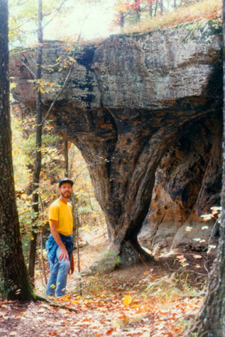 Me and a "Mushroom" Formation |
(Picture at left) The trail was on level terrain, but to the side, a valley was sloping down, until we found ourselves walking on top of a giant rock ledge. From the top, you can't see much, but there were plenty of places to get down below to see the amazing formations. Here is a pillar holding up the rock ledge. I am actually a good deal in front of the rock, and I estimate that it is about fifty or sixty feet high. I am not sure how such formations form, but I suspect that water must have had something to do with it, or perhaps wind, but in any case, the formations were very, very interesting. Too sheer to climb, though.
(Picture at right)
|
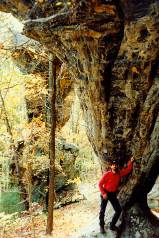 Fred at the "Mushroom" Formation |
These uniquely weathered columns all had a smaller, narrower base than their tops, and that's why they looked like mushrooms (very tall and thin ones, though). The trail continues along this bluffline for approximately a half mile or so, and we saw formation after formation.
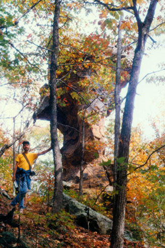 Me and One of the Pedestals |
(Picture at left) Along the cliff face, the trail sloped up and down, and around every bend there was some new, dramatic formation. Actually, the main trail is still up above; we just decided that you could see more of interest down below. The forest was not thick at the base of the cliffs, so the hiking was almost as easy as on a level trail. There were a few places where you could get up and down to the main trail, but not many. Anyway, this was a lot better, and there was a little path so we knew that many others had come this way also.
(Picture at right)
|
 A Free-Standing Pedestal |
As we walked along the trail, when we were up on the bluff, there were amazing views out to the south and east; when we were down at the base of the pedestals, we found of course those incredible formations but also lots of little shallow caves and rock niches to explore.
 From an Overlook on the Pedestal Rocks Trail There were a number of places along the trail that runs on top of the cliff face where overlooks had been constructed, and this one had some of the better views we saw. This looks southeast; it is early afternoon. We learned later that we had missed the peak foliage, but it was still better than Dallas. |
 Fred Inside a Natural Cave Overhangs Further along the trail, the area under the ledge opened into shallow caves, like this one, that might go back fifty to a hundred feet into the hillside. This one had numerous openings, including a large one to my left. This one doesn't lead out to the trail, but rather to a sheer drop-off of about twenty feet. There was seeping water in some of these "caves," but I don't think that's what formed them. |
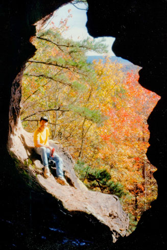 |
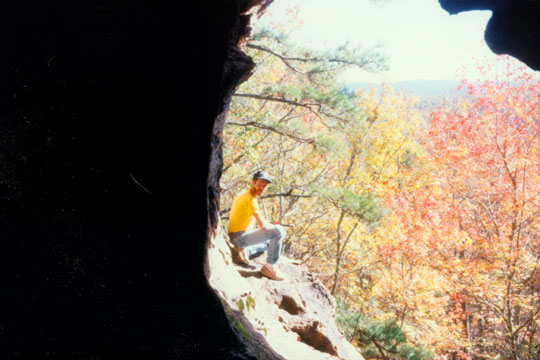
(Picture at left) Here, I am sitting outside one of the cave entrances along the Pedestal Rocks Trail near Limestone, Arkansas. This picture was taken from the same location as the left-hand picture in the section below, but from a different angle, and I think the resulting picture is even more intriguing than the other one. I like the way the trees and foliage behind me show up very well here, and you can get an even better idea of how far up the hillside we are.
(Picture at right)
|
 |
We saw a good deal of evidence of modern "camping" in these formations, although there was little refuse to speak of; I guess the hikers are a pretty considerate bunch.
 Me Outside a Cave Entrance on the Pedestal Rocks Trail Here is a good shot showing where the caves are in relation to the hillside. The trail is either up above, on the ledge, or down below. From the height of the trees behind me, you can estimate that there is a thirty or forty-foot drop off below me. Fred is actually looking around a pedestal; there was another entrance to this particular cave just to my right. I particularly like the way he composed this shot. |
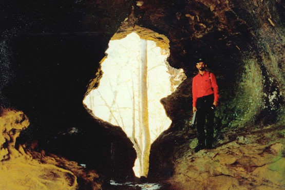
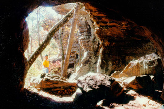 A Cave Along the Pedestal Rocks Trail Fred likes anything having to do with caves, and the small ones along this trail presented lots of interesting features. This was a particularly large one, with lots of "rooms" and lots of entrances. Behind me, you can see a whole row of pillar formations along the cliff face. This particular cave winds behind most of them. |
Up on top of this formation, the ledge seems to be level and solid, but there were numerous holes and cracks that looked down into the area around the base of the pedestals. It was much more disconcerting to be walking about up there than down here. At least here you didn't run the one-in-a-million risk that a piece of rock would finally break free the moment you stepped on it. Besides, from up there, all of this is invisible.
At one point, I scrambled down below the ridge face with Fred so he could take a panoramic picture looking back at the ridge:
 |
For the last quarter mile along the bluff, the views were simply amazing- particularly when you could look out across the top of one of the pedestal formations, and the picture below is a good example of this:
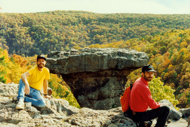 |
The picture shows me and Fred on top of the ledge along the bluff, and you can see the top of a pedestal about twenty feet out from the bluff edge and about level with our perch. I thought this was an extremely interesting shot, I think, as the pillar itself looks almost artificial.
This scenic area is best explored in the spring and fall, offering wonderful waterfalls and beautiful fall colors. From this point, we tried to follow the rather confusing directions back to where the car was. After a couple of false turns, we finally decided to just follow our noses. So we picked what we thought was the likely return trail through the woods and set out. After a while, the markings began to get in synch with what the guidebook had said, so we had little fear that we were getting lost. This was a great hike, and we got back to the car about four in the afternoon.
|
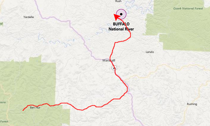
From there, we drove up Arkansas Highway 27 to Harriett, and then north on Arkansas Highway 14, across the Buffalo River, to Arkansas Highway 268 leading to the Buffalo River State Park, and specifically the Buffalo Point Campground- our camping destination for the evening.
We'll look at the details of the area where we camped on tomorrow's page; we had no problems getting there and getting a campsite (that's the nice thing about taking Fall trips after school is back in session) right by the river, which we could hear it all night.
Before dinner, we decided to take a hike up a trail that parallels the road down to the campsites. It was getting pretty dark, but we could just see to make our way. The trail led all the way up to the cabins at the main highway. Then we walked back down the park road to the campsite, it being entirely too dark to return through the woods. Lions and tigers and bears- Oh my! We had dinner and then to bed. No repeat of the rain disaster this time!
You can use the links below to continue to another photo album page.
|
October 28, 1995: Fall Trip to Arkansas: Day Three |
|
October 26, 1995: Fall Trip to Arkansas: Day One |
|
Return to the Index for Our Fall Trip to Arkansas |