|
July 12, 2002: Colorado Trip Day 7 |
|
Return to the Index for Our Colorado Trip |
|
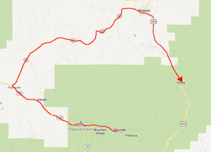
Bear Creek Falls Telluride, CO Driving Through Ouray, CO Red Mountain Pass Silverton, CO and Home |
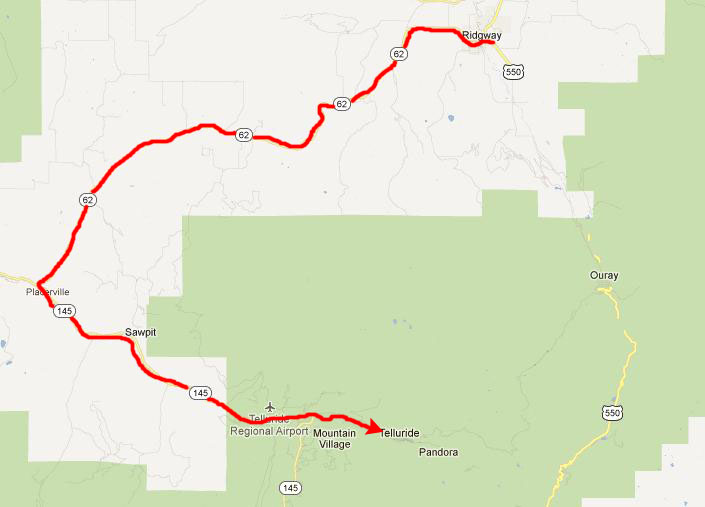
For our last day, we are going to head over to visit Telluride, CO, and Bear Creek Falls. After that, we will begin working our way south towards Silverton and on home to Dallas tomorrow.
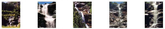
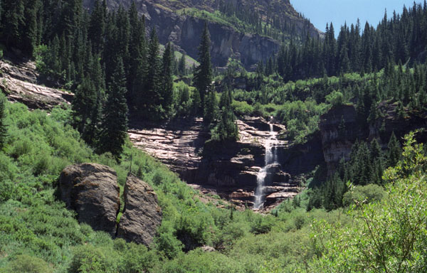
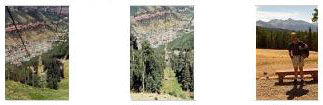
Bear Creek Falls in Telluride, CO
|
So we will be retracing this route later today after we've had a chance to hike to Bear Creek Falls and then walk around Telluride for a while.
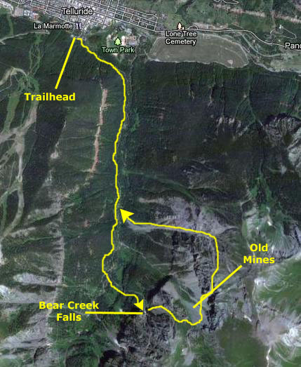
We arrived in Telluride about an hour after leaving Ridgway, found a parking space (not as difficult in the summer as in the winter, I expect) and followed our directions to head off to the trailhead for the Bear Creek Falls hike.
|
The trail climbed slowly and steadily; we would be ascending about 1300 feet from the trailhead to the falls. That may sound like a lot, but the way the topography is along the trail, we will also be descending 1299 feet from the trailhead to the base of the falls. So, even though we'll be doing a lot of climbing, the net change in altitude will be one foot less at the falls than at the trailhead!
The meadow ran out quickly and we climbed to the top of a ridge; the trail continued along that ridge almost all the way to the falls.
|
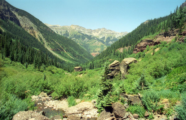
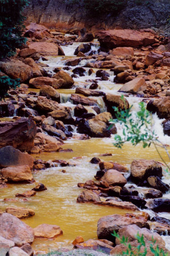
As the trail climbed, we cruised through stands of aspen, ponderosa, and open meadows. We could see evidence of early 20th century mining alongside the trail and on the far side of Bear Creek to the left. We'd see more of that in the area near the falls themselves.
After climbing above the creek, the trail finally hits the banks of Bear Creek near mile 1.5. Across the creek is a stream and scree field on the flanks of Ballard Mountain. A short while later, the Wasatch Trail broke off from our own path and led uphill to our right. We stayed on the much larger main path which continued alongside the creek. After another half mile, we reached Bear Creek Falls.
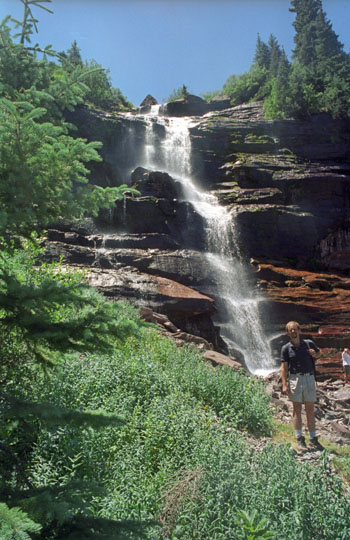
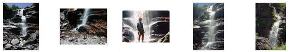
When we got to the falls, there were some other folks already there, but it was not so crowded that it in any way detracted from the beauty of the falls themselves.
|
|
|
The falls were beautiful and inspirational- what with the wide open space and the towering mountains on all sides. I can see why people would put up with the winters to be in such a glorious place in the summer.
|
|
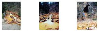
From the falls, we wanted to cut across the bottom of the valley to go see some of the remnants of the old mining operations that were nearby. So we went to our left across the bottom of the falls, crossing another little rivulet that had its own little waterfall, and climbed the slope to the left of Bear Creek Falls. As we did, we got what I thought was a really amazing view of Bear Creek Falls with the towering mountains in the background. This view made me wish we had all day to spend here; those mountains looked so inviting as climbing objectives, especially since I could see routes to the top that wouldn't involve much more than carefully scrambling up rocky slopes.
|
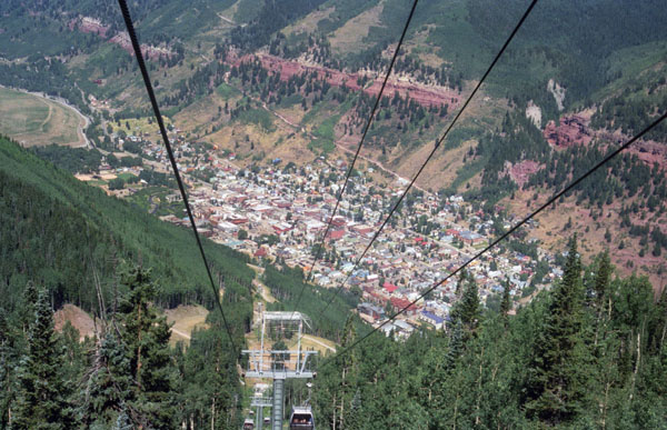
We climbed back down towards Bear Creek, crossed over the creek and back up the other side of the valley to meet up with the trail back to Telluride. We walked back down the trail, luxuriating in the mid-day sun, until we came again in sight of Telluride. This time, we paused on the trail to take some pictures with the town of Telluride down in the valley as a backdrop, and you can see Fred's picture of me here, and my picture of Fred here.
The Bear Creek Falls hike was really a pleasure, and now we headed down into town to do a little exploring.
You can return to today's index
or continue with the next section below.
Visiting Telluride, Colorado
|
|
It was simply a beautiful afternoon to enjoy such wonderful scenery.
|
|
After spending some time up here enjoying the afternoon, we reluctantly headed back down to get the car and begin the journey home.
You can return to today's index
or continue with the next section below.
The Drive Home: Ouray, Colorado
|
|
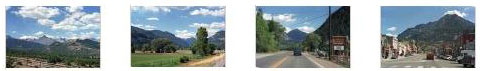
If you will click on the thumbnails below, you can see a couple of highway scenes along Route 62 and then a couple of pictures we took as we passed through Ouray itself:
|
Ouray is at the northern base of Red Mountain Pass is the town of Ouray. Mount Abrams, to its south, and the Amphitheater formation, to its east, tower 5,000 feet over the town. Unlike many mining camps, Ouray never experienced a large fire. Because of that, it has many well-preserved, historic structures, including hotels, opera houses and a courthouse.
Most believe that prospectors first arrived in the valley in 1875, traveling from Silverton to the south. Ouray incorporated a year later, and by 1880 more than 2,500 people lived there. In 1887 the Denver & Rio Grande Railway completed a line to Ouray and opened a depot there the following year.
A narrow gauge railroad excursion came to Ouray in the same year, allowing the Denver & Rio Grande Railroad to promote its �Around the Circle� tours. The route traveled from Pueblo to Salida, then over Marshall Pass to Gunnison. It then continued to Montrose and turned south into Ouray. From there, travelers rode stagecoaches up the Uncompahgre Gorge along the route of the Otto Mears Toll Road to Chattanooga at the base of Red Mountain Pass. They then rode the Silverton Railroad to Silverton. In Silverton, they changed trains and rail lines to ride the Rio Grande to Durango and continue over La Veta Pass to Pueblo. These tours became very popular over the years.
You can return to today's index
or continue with the next section below.
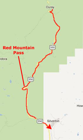
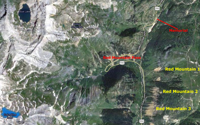
The Drive Home: Red Mountain Pass
|
|
|
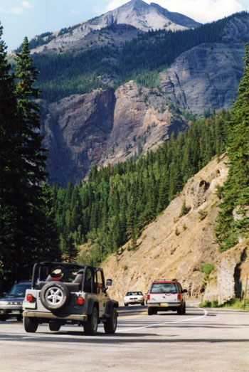
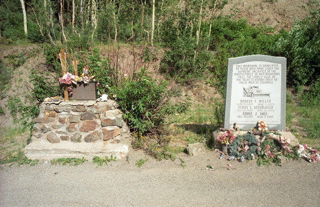
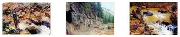
The pass is known for being treacherous in the wintertime due to the steep 8% grade and switchbacks on the north side facing Ouray, though the entire road is paved. In addition, there are very few guardrails on this side and passing is difficult, if not impossible. Driving it in winter is not for the faint of heart; indeed, three men have died maintaining the pass, and there was a memorial to them on the roadside north of the pass. You can also see these memorials in the picture at left.
The most intimidating paved Colorado highway may well be that on the north side of Red Mountain Pass. This section of U.S. 550 is narrow and has tight curves, precipitous drops, and few guardrails. The shoulder drops 300 feet straight down into the Uncompahgre Gorge, cut through by the Uncompahgre River. It is spectacular!
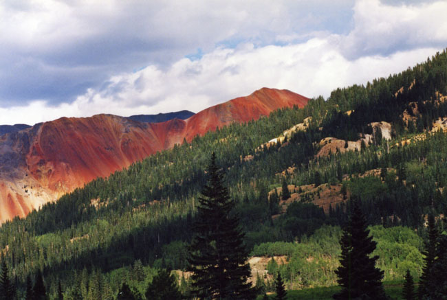
The pass is named for the nearby Red Mountains 1, 2 and 3 on the east side of the pass. Their names are derived from the iron oxide laden rock that forms their slopes.
|
Before the railroad reached Ironton, most travelers going south from Ouray used The Otto Mears toll road. Mears took over the road from the Ouray and San Juan Wagon Road Company on April 1, 1880. Using techniques learned in other road construction projects, he completed it in 1884. Pack trains of mules and burros used this road to move all the supplies the town of Ironton needed and carry out the ore from the nearby mines. It was not easy. Travel on the road was tough because of steep grades, sharp curves, narrow trails, precipitous drops, and a rough roadbed.
With the advent of automobile travel in the 1920s, the 12 miles of Mears' toll road that ran south of Ouray through the Uncompahgre Gorge became part of the �Million Dollar Highway� at great redesign costs. Cutting the road into the cliffs of the Uncompahgre Gorge was no easy task, and the project was very expensive. This part of the highway has changed little since its completion in 1924!
|
|
It didn't turn out to be very deep at all. I guess we didn't expect anything more than a natural crevice or animal den.
|
The Million-Dollar Highway was incredibly beautiful; we learned much later that it is included in a number of lists of the most scenic drives in America.
You can return to today's index
or continue with the next section below.
The Drive Home: Silverton, Colorado and Home to Dallas
|
We came out on the ridge above the town of Silverton late in the afternoon. As it turned out, we would visit Silverton again a few years hence when we took a ride on the Durango-Silverton Scenic Railway. By then I had my own digital camera, and you'll get to see some movies of the area.
|
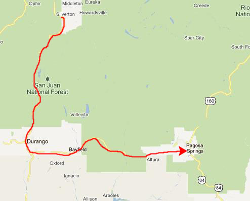
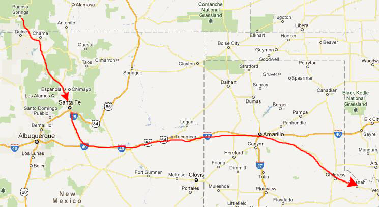
So we continued south on US 550, passing through Durango, Colorado, and then headed east towards Pagosa Springs.
|
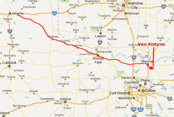
We stayed the night northwest of Santa Fe, leaving us the long and mostly boring drive home for Sunday. From Santa Fe, we dropped down to I-40 which took us east past Amarillo. There, we angled off southeast on the very familiar road to Wichita Falls.
|
It was a really great trip, but then I don't think Fred and I have taken a bad one.
You can return to today's index
or use the links below to continue to another photo album page.
|
July 12, 2002: Colorado Trip Day 7 |
|
Return to the Index for Our Colorado Trip |