|
October 31, 2002: Arizona Trip Day 6 |
|
October 29, 2002: Arizona Trip Day 4 |
|
Return to the Index for Our Arizona Trip |
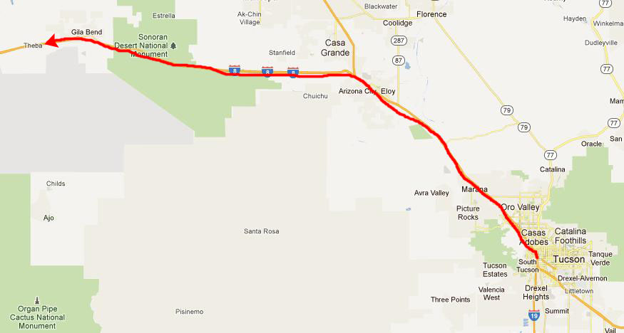
Today we are going to drive almost all the way to the California border to see the Petroglyphs at Painted Rock, and then we'll drive northeast up to Phoenix to camp for the night.
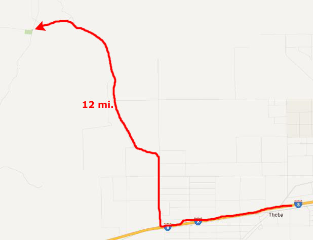
Getting to the Painted Rock Petroglyphs
|
|
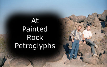
The Painted Rock Petroglyphs
|
Painted Rocks is located along a number of important historical routes, including that of Juan Bautista de Anza's expedition of 1775-1776 (the expedition that founded the city of San Francisco); the route of the Mormon Battalion; and the Butterfield Overland Mail stagecoach route. As a result, the site contains inscriptions made by travelers in these and other groups along with the petroglyphs. Sadly, some additional crude inscriptions have been made by modern visitors with no sense of history.
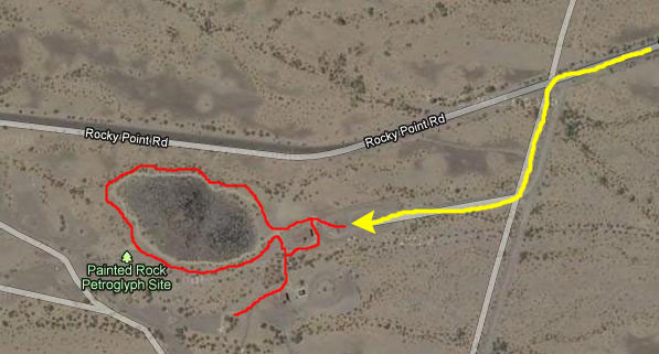
Prior to 1989, the site existed as Painted Rocks State Park, and included camping facilities on the nearby Painted Rock Reservoir referred to as the "Lake Unit". When the state turned control of the park over to the BLM in 1989, the Lake Unit was closed due to concerns over pollutants in the Gila River and is not maintained by the BLM. There is a picnic area and some other primitive facilities here, but the site is not usually manned except for a few months in the summer. You can see the parking area, facilities and the trailer occupied by the site hosts if you click here. Basically, the viewing of the petroglyphs is from one main circular trail around the pile of boulders that comprise the site; there is also a short trail to another few boulders with some additional markings.
|
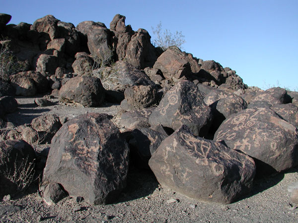
We did find that some native peoples have called this area home for thousands of years, and that they believe they are descended from the people known as the Hohokam. These petroglyphs have accumulated over a broad reach of time estimated from 7500 B.C. to 1450 A.D. (not counting the recent graffiti). Walk along the loop trail and see the various rock art depictions of animals, people, shapes, and events. There wass also an abundance of lizards calling the site home.
I should point out that the loop trail did, fortunately, have some offshoots that led at least partway up into the boulders so that visitors could see some of the most interesting petroglyphs up close. This made the site even more interesting, and we took all of these side trips. (So when you see one of us standing a ways up the boulder pile, please don't think we ignored the admonition to stay on the trail; a sign at the ground-level trail would tell us when we could walk up into the boulders.)
There is actually little else I can tell you about the petroglyphs here, except to say that they were more numerous than just about any other site we've visited before or since. So let's just take a look at some of the pictures we took as we were walking around the loop trail.
|
As for the rest of our pictures, I think that the best thing to do is to create a slideshow. To view the slideshow, just click on the image at left and I will open the slideshow in a new window. In the slideshow, you can use the little arrows in the lower corners of each image to move from one to the next, and the index numbers in the upper left of each image will tell you where you are in the series. When you are finished looking at the pictures, just close the popup window.
Although it was a long drive out here, and there wasn't another "attraction" nearby, the effort was worth it; as I said, I don't recall ever seeing so many petroglyphs in one place before. We spent a couple of hours here, and then headed off to spend the night at a State Park near Phoenix that Fred found on the Internet.
|
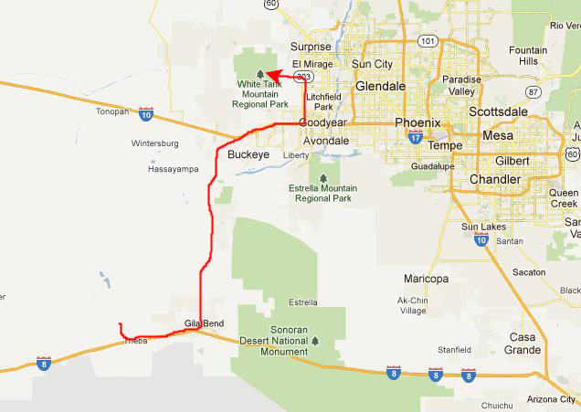
To get there, we drove back down to I-8 and went east to Gila Bend. There, we took a paved Arizona highway north, wandering through the desert until we intersected with I-10 west of Phoenix. We headed east and then took Highway 303 north.
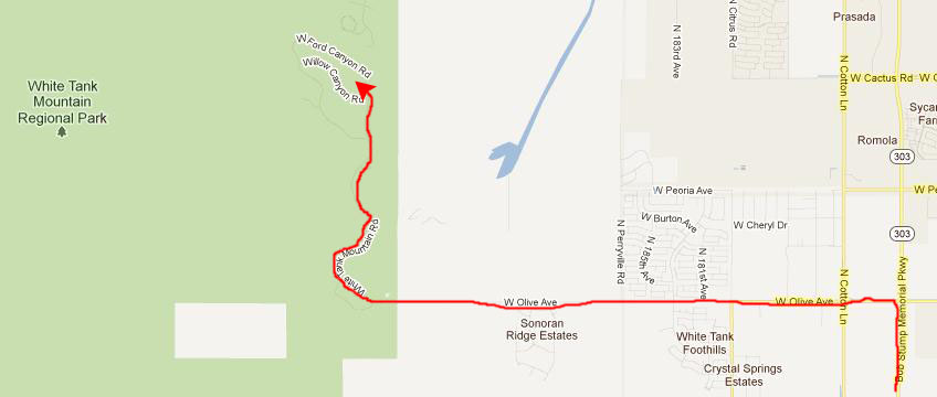
We got off Highway 303 at Olive Avenue- one of the prime east-west roads through the Valley of the Sun (Phoenix and Scottsdale)- and headed west. Eventually, we ran out of civilization, the road climbed, and we found ourselves at the small entrance station for White Tank Regional Park. We followed the park road as it climbed along the eastern ridges of the White Tank Mountains and eventually arrived at the campground.
|
We found a great campsite that overlooked the entire valley; Phoenix lay spread out below us. Tomorrow, we'll look at some pictures we took here, but for this evening, we set up the tent and had one of Fred's campground meals before we hit the sack on this now chilly late-October evening.
You can use the links below to continue to another photo album page.
|
October 31, 2002: Arizona Trip Day 6 |
|
October 29, 2002: Arizona Trip Day 4 |
|
Return to the Index for Our Arizona Trip |