|
Florida Trip: At the Beach |
 |
Florida Trip: Along the Riverwalk |
 |
Return to the Florida Trip Index |
Our Florida Trip:
Riding Our Bikes
Around Fort Lauderdale
One of the first things I did when I started coming down to Fort Lauderdale frequently was to go buy a decent bicycle. Fort Lauderdale, and especially the beach area, is a great place for bike riding, and lots of folks, young and old, do it regularly. Unlike Dallas, many of the main streets, again particularly along the beaches and Highway A1A that parallels the shore, have dedicated bike lanes, making it both pleasurable and safe to ride along with the traffic.
When Fred started accompanying me more frequently to Florida, we got a bike for him as well, and we have gotten a great deal of use out of them.
On this page, I'd like to put the pictures and movies taken on some of the bike trips that we took during our week here this spring.
A Bike Ride to Boca Raton
Many of the rides Fred and I take here in Fort Lauderdale are fairly short- maybe twenty or twenty-five miles round-trip. A trip of that length will take us north to Hillsboro Inlet, where there is an access from the Intracoastal Waterway out to the ocean. South of that, the next inlet is quite near the condo at SE 17th Street- Everglades Inlet. This inlet provides ocean access for not only the cruise ships that dock in Lake Mabel, but also the multitude of boats that are kept in and near downtown Fort Lauderdale. North of that, the next inlet is at Boca Raton, and it provides ocean access for all the boats that ply the Intracoastal from there up to the next one at Boynton Beach. These inlets come along about every ten miles or so along the barrier island between the Intracoastal and the ocean, the island that carries A1A.
When we want a longer ride, though, we go all the way to that next inlet at Boca Raton, and then usually another four or five miles to Spanish River Park, where we can ride our bikes through the park and then visit the Nature Center at Gumbo Limbo, just about a half mile south. This is the ride we decided on doing today.
Below I have put a scrollable window containing a strip map for the route of the bike ride we took up to Gumbo Limbo. To begin the ride, you should scroll all the way to the bottom of the map; then you can follow us along as we go.
Most of our rides begin with the two miles over to the beach; we head east on SE 4th Street, curve around north to meet Las Olas, and then head east again the two miles until Las Olas dead-ends into the ocean and A1A. Then we turn north and continue in that direction for about twenty-five miles to reach Spanish River Park. The first section takes us along the Fort Lauderdale beachfront; this section is about two miles long, at which point A1A goes a block or two inland from the beach. This was done many years ago, presumably to allow development of the actual beachfront for houses (or maybe the houses came first- I'm not sure). But now, almost all the houses are gone, having long ago been replaced by apartments and later by twenty- and thirty-story highrises. Most of these were originally built in the 1960s and 1970s, although right at the point where A1A curves inland they are newer. The first building north of the beach is the newest; it is a cooperative that is eight floors high. I understand that there is just one unit per floor, and the units range from two to four million dollars. Just north of that is another newer high-rise, almost as exclusive. It is called The Palms, and we stopped briefly at
the fountain
right in front of it along A1A.
Our route continues past Oakland Blvd. where an area called the Galt Ocean Mile begins. This is a one mile stretch where there are two blocks between A1A and the ocean. Right along A1A to the east are low-rise commercial buildings- restaurants and stores. The block along the beach is solid highrises- both apartments and condominiums. I am not sure where the name comes from, but it is a desirable place to live.
At the end of that mile or so, there are still two blocks between A1A and the beach, but now we can go one block east to a side street to continue north. This next two-mile stretch takes us through and area known as Lauderdale-by-the-Sea, a place we sometimes come to eat lunch by the ocean. Then we get back on A1A (in the bike lane) to go another three miles and then again cut over to the beach to go through the suburb of Pompano Beach. The ride along the beach at Pompano is another two miles or so and then we again meet up with A1A. Then it is a three mile stretch that brings us to Hillsboro Inlet- about 12 miles from our starting point at the condo. On the north side of the Hillsboro Inlet drawbridge we are in the town of Hillsboro Beach where to the right of A1A, between it and the beach, are multi-million-dollar mansions. A few miles further north the mansion row ends and we encounter a long stretch of more modest oceanfront homes, apartments and condominiums- few of them taller than a couple of stories. About three miles later we enter the town of Deerfield Beach.
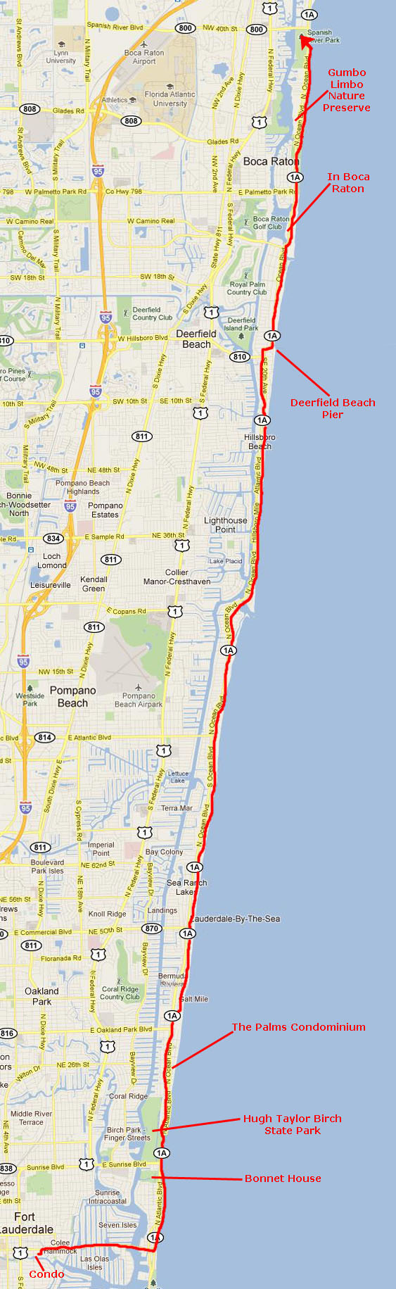
After a couple of more miles, A1A makes an "S" curve to go closer to the beach before continuing north. This is the center of Deerfield Beach, and it is another good place to go eat for there are a number of good restaurants here. There are also a couple of hotels and the Deerfield Beach Pier. There has been a lot of renovation here since 2003, and the area look much better than it used to. The pier is pretty much the same though, and you can see a couple of views of it if you click on the thumbnail images at left.
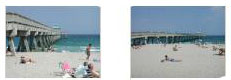
Another two miles or so brings us to the bridge across the inlet at Boca Raton, and then it is a final three miles or so to Spanish River Park. This stretch along A1A is not so congested as down in Fort Lauderdale. The high-rises are shorter and spaced further apart. Interspersed among them are individual homes- all of them very nice and, I assume, very expensive. But then Boca Raton has always had a certain cachet (although the English translation of the Spanish name would not be nearly so evocative of old money). At a couple of points along this stretch, we stopped to take a photo, and you can have a look at these if you will click on the thumbnails at right.
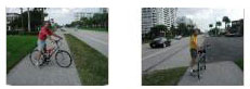
We continued on to Spanish River Park, and then turned around, came back south a bit and stopped in at the Gumbo Limbo Nature Center. Founded in 1984, Gumbo Limbo Nature Center is a unique cooperative project of the City of Boca Raton, Greater Boca Raton Beach and Park District, The Palm Beach County School District, Florida Atlantic University (FAU), and Gumbo Limbo Nature Center, Inc. Each year, more than 100,000 local and tourist visitors receive valuable environmental education while enjoying respite from the city bustle. As a beacon for environmental education, research, and conservation, Gumbo Limbo�s 20 acres of protected barrier island not only provides refuge to many varieties of plants and animals - some rare or endangered - but represents a commitment to protect our natural resources by our members, volunteers, and the organizations that comprise the Center.
The main areas to tour are the exhibit building, the five large fish tanks west of the main building, the boardwalk that winds through the forest and swamp to the south of the main building (a portion of which can be seen in the picture at left), and the observation tower that is out in the middle of that forested wild area.
One place we always visit here are the four large fish tanks to the west of the main building. Here, there are always a variety of sharks, turtles and other fish to see, learn about and, at the right time, help feed. Today, Fred just snapped a picture of
a fish
and one of the many
turtles
out here in the fish tanks.
Then we headed out the south door of the main building to pick up the boardwalk trail through the mangrove swamp. There are two "destinations" on the boardwalk. One is the shore of the Intracoastal Waterway (the east bank, of course). There we stopped to take a couple of pictures, one of
Fred
and one of
me.
We got back on the boardwalk and wound our way through the swampy forest to the observation tower, and began our climb to the top. Just before we reached the top, Fred looked back and got a picture of
me on the landing.
If you are curious, the picture is looking north.
We took a number of pictures at the top of the tower, and you can have a look at them if you click on the thumbnails below:
Fred also made a movie here at the top of the observation tower, and you can watch it with the player at right.
It was getting on towards late afternoon, so when we were done at the observation tower, we walked back to the main building, got our bikes, and then retraced our 25-mile route back to the condo. It was an excellent bike ride on a great day.
A Bike Ride to Fort Lauderdale Beach
Most afternoons, we ride over to the Fort Lauderdale beach and just pedal along the beachfront from Las Olas to the north end of the beach and back; it's about a six-mile round trip. It's a way to get out in the sunshine and get a bit of exercise without getting too far from the condo. Sometimes, we combine it with our stop in Holiday Park to play with the Frisbee.
At left is a map of the route we usually follow. The three main sections are the stretch along Las Olas causeway that links the finger islands, the crossing of the Intracoastal on the Las Olas drawbridge, and then the stretch along the beach north almost to Oakland Park Blvd.
Biking Along the Las Olas Isles
From the condo, we head east on SE 4th Street and then north a block to Las Olas. From there, it is east along Las Olas through an area known as Colee Hammock (a "hammock" being a piece of land that stands higher than the surrounding area, although in this case it isn't but a few feet higher. Then it is over a bridge that spans the first small canal and we enter an area that has artificial island fingers going north and south from Las Olas. On the north, the fingers are variously named- with the six of them being the Hendricks, Venice and Nurmi Isles. East of that there is an even more upscale area called Seven Isles- with the ends of these east-west fingers pointing out to the Intracoastal. On the south are the Las Olas Isles, the most upscale area of all, with the fingers going north-south again, and with the south ends pointing out into the area where the New River becomes the Intracoastal Waterway. There is a lot of boat traffic here, so the views are better. I once inquired about a vacant lot at the end of one of these isles (there are two lots at most of the ends) and found that just the lot was priced at $2.2 million. Add a suitable home to that and you are easily north of $4 million. These lots are very, very sought after. Each of these southern islands has a set of unique
entry gate pillars,
although there actually aren't any gates.
In any event, we always like biking along this stretch, although by now it has become very familiar. There are many beautiful homes, canal vistas and, of course, boats galore. Some of them belong to homeowners and are docked in the canal back of the home. Others are owned by people who live elsewhere and who rent dock space from homeowners who aren't using them. If you'll click on the thumbnail images below, you can see some of the pictures that we've taken along this stretch of Las Olas:
Crossing the Las Olas Bridge
Leaving the Las Olas Isles, we come to the bridge that takes Las Olas over the Intracoastal Waterway. There are always good views from the top of the bridge, although today we didn't take any pictures there.
But Fred did take two pictures looking north from the bridge at the new buildings on the Intracoastal side of the barrier island- one picture taken from the west end of the bridge and another taken from the marina that is just north of the bridge on the barrier island side. Click on the thumbnails below to have a look at these two views:
From the same vantage point at the eastern side of the bridge, Fred took a picture of one of the newest
condominium buildings
that has been built in the last few years over on the beach side. I understand that there are plans for five or six new buildings right on the beachfront north of Las Olas.
Biking Along the Beach
Once we are at the beach, we usually head north, with the distance we go depending on how nice the day is and how much time we have. On this trip, we just went north to the end of the beach and then turned around and came back. If you will click on the thumbnail images at right, you can see some of the pictures we took.
Biking to Lake Mabel
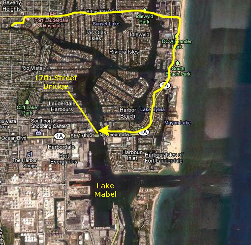
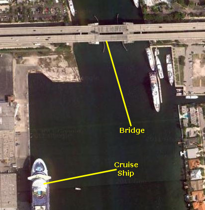
One interesting ride we take every once in a while involves heading south instead of north once we get over to the Fort Lauderdale Beach. This route takes us south along A1A until it curves around west and crosses the new 17th Street Causeway bridge. A1A can't continue south; Everglades Inlet is in the way. And since the inlet is used by the cruise ships that dock in the Lake Mabel, the bridge over the inlet would have to have been a major affair, and would have involved approaches that would have necessitated the demolishing of a goodly number of pricey homes and luxury condo buildings. It just wasn't worth it to cut ten minutes of the trip down A1A (which is supposed to be scenic anyway. In the aerial view at left, below, you can see what would have been involved.
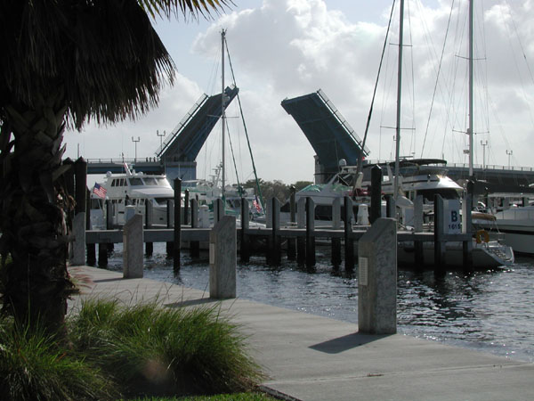
When we come down here, we usually bike across the bridge and back. It is much more pleasant a ride to avoid going further west and taking either Federal Highway (through the Kinney Tunnel) of one of the downtown bridges back to the condo. We usually stop at the top of the bridge to admire the view.
In the aerial view above, you can see the bridge clearly, and I've also shown the northernmost of the cruise ship docks (which had a ship docked when the aerial view was taken). In Lake Mabel there is currently space for perhaps five large cruise ships; the port is one of the busiest cruise ports in the country. I might note, looking back as I write this in 2011, that Port Everglades (the name for the Fort Lauderdale cruise ship port) was poised for a breakthrough expansion. In the years since, a major expansion and renovation of the entire cruise ship port has resulted in a port that can handle 11 cruise ships at one time- including the world's two largest ships (Oasis of the Seas and Allure of the Seas). On December 23, 2006, the port would set a record with over 47 thousand passengers entering and leaving the port in a single day. That record was broken just three years later, on January 3 2009, when over 49 thousand passengers entered and left the port in one day on 11 ships. The new Port Authority has said that if all 11 cruise ships lined up bow to stern it would have stretched 9,869 feet or the equivalent of nearly 31 football fields. That is enough cruise passengers to fill 105 747 jumbo jets, and the equivalent of approximately one-third the population of Hollywood, Florida. Now that the Oasis-class ships have arrived, those records are sure to fall as Fort Lauderdale has now become the world's busiest cruise ship port- far surpassing Miami.
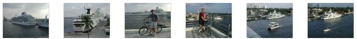
Below are some of the pictures that we took from the top of the 17th Street Bridge, looking south into Lake Mabel. You can see both the residential, east side of the harbor as well as some of the cruise ships docked along the west side of the bay:
You can use the links below to continue to the album page for different day.
|
Florida Trip: At the Beach |
|
Florida Trip: Along the Riverwalk |
|
Return to the Florida Trip Index |