|
June 23, 2003: Western Trip, Day 3 |
|
June 21, 2003: Western Trip, Day 1 |
|
Return to the Index for Our Western Trip |
|
June 22 Salinas Pueblo Missions NM Petroglyph NM El Malpais NM |
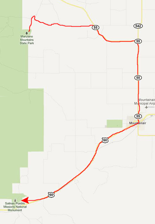
We got up fairly early on Sunday morning, struck the campsite, and then spent some time in the Ranger Station talking with the ranger and looking at more of the exhibits. Then we headed off for our first stop today- the ruins of the Salinas Pueblo Missions somewhat south of the park.
The Salinas Pueblo Missions National Monument
Getting to the Salinas Pueblo Missions NM
|
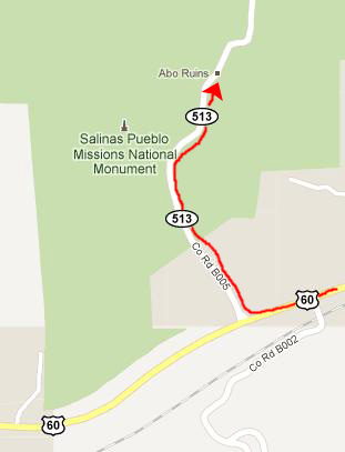
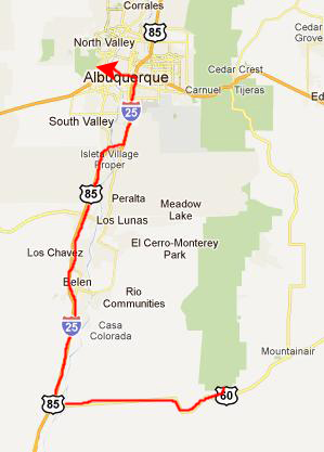
From Mountainair, it was a straight shot down US 60 to the Salinas Pueblo Missions NM. We just turned north on a county road to enter the National Monument:
|
History of the Salinas Pueblo Missions NM
What remains today are austere yet beautiful reminders of the early contact between Pueblo Indians and Spanish Colonials. The ruins of four mission churches, at Quarai, Abó, and Gran Quivira and the partially excavated pueblo of Las Humanas or, as it is known today, Gran Quivira. Established in 1980 through the combination of two New Mexico State Monuments and the former Gran Quivira National Monument, the present Monument comprises a total of 1,100 acres.
|
The Gran Quivira ruin first became a National Monument on November 1, 1909. As with all historic areas administered by the National Park Service, the National Monument was listed on the National Register of Historic Places on October 15, 1966. On December 19, 1980 it was enlarged and the two other ruins, which had been designated as New Mexico State Monuments, were absorbed on November 2, 1981. It was renamed to Salinas Pueblo Missions NM on October 28, 1988.
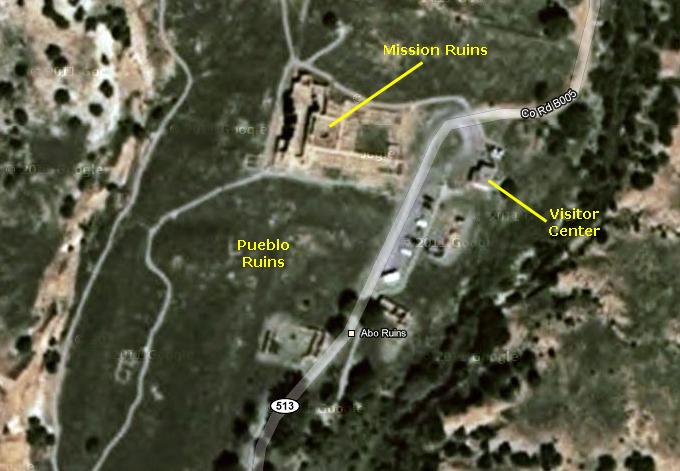
The Abó Ruins are about 6100 feet above sea level. There is a visitor contact station and a half-mile trail through the mission ruins and a similar trail around the unexcavated pueblo ruins.
Our Tour of the Abo Ruins
|
When we got out of the visitor center, we crossed the parking lot and the road to arrive at the beginning of the path to the mission ruins about three hundred feet away.
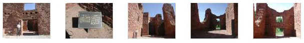
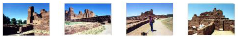
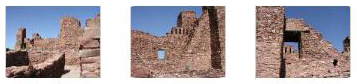
When we got a bit closer, both Fred and I took pictures of us in front of the ruin. About halfway down the path, I took a picture of Fred and I and the mission ruins, and when we got a bit closer, Fred took an even better picture of us and the ruins. And then we went in what had been the front of the church to have a look around.
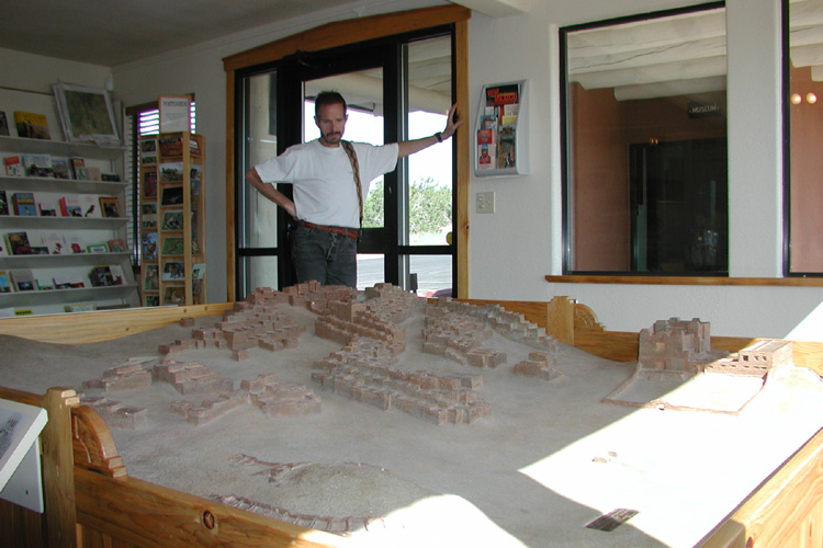
I think we can divide our tour of the ruins into two sections. The first would be our walk through the church proper- what we would think of as the sanctuary- and the other would be our walk through the ruins of the various attached buildings and rooms. So I'm going to divide the picture we took into those same two sections below.
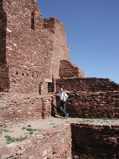
When we went into the main entrance of the sanctuary, the first thing that impressed me was how tall the ruins were. Here is a picture of Fred in an alcove to the side of the sanctuary, standing at the base of the the three story walls, behind which there were other rooms (you can see the windows looking out from the top room). I know there are limits to what you can do by simply stacking up stones, but still, this was pretty impressive.
Here are some of the other pictures we took in and around the sanctuary; to view them, just click on the thumbnail images below:
|
|
|
|
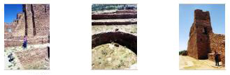
Fred took three other excellent pictures here amidst the ruins, and if you will click on the thumbnails below you can have a look at them:
|
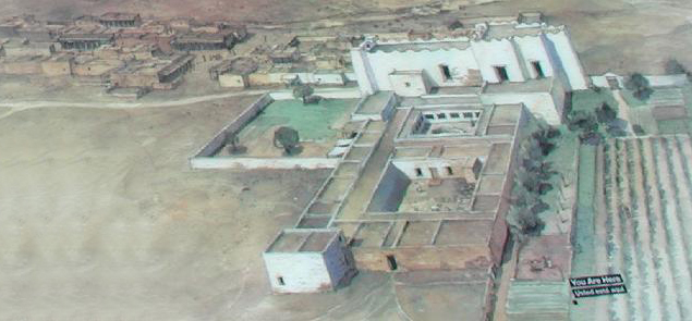
We spent quite a bit of time wandering among the ruins of the other rooms that were attached to the main sanctuary- rooms of all kinds and all sizes. Eventually, though, we worked our way to the path leading away from the Abo ruin and back towards the parking area and Visitor Center. Along that path, we came to a very interesting informative sign that explained quite a bit. One thing that it did have was an artist's conception of what the village and mission might have looked like in the 1660. That image is below, left.
|
"In the 17th century, an ancient trade route that linked the Rio Grande to the Great Plains shared this fragile mountain valley with a bustling pueblo full of people who spoke Tompire. When a single Spanish priest walked into town in 1622, a spiritual, material, and cultural revolution started in Abo. Nothing would ever be the same again."
"The new stone church and convento were large compared to Abo's earlier houses and plazas. This artist's concept shows the village and mission as they may have appeared in the 1660s."
"For the Tompiros, the well-known trail across Abo pass had always brought tradegoods, travelers and new ideas this way. Who could have foretold that the arrival of a single friar might change their world forever?"
"For a Spanish priest, Abo was the remote edge of a vast and growing empire that included outposts in Asia, Africa, the Americas and Europe."
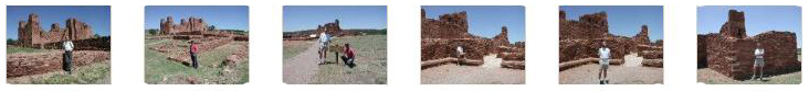
Finally, I'd like to include six more pictures that Fred took here at the Abo ruin; just click on the thumbnails below to view them:
|
Looking around the ruins here at Abo was certainly interesting, but now it was time for us to look at something much older.
You can return to the page index or continue on to the next section.
Petroglyph National Monument
Getting to Petroglyph NM
|
|
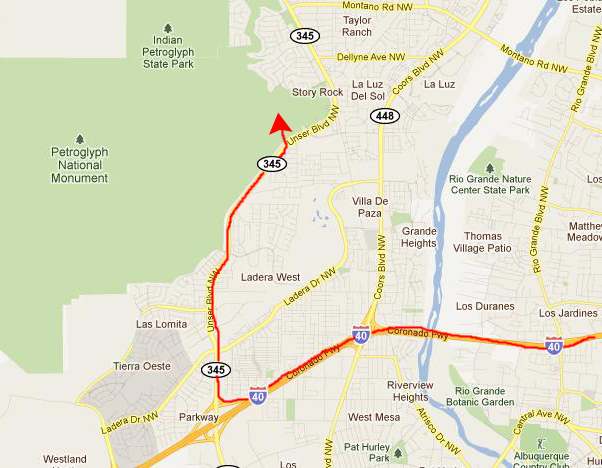
We got off I-40 on Unser Blvd., and then headed north. It begins to border the National Monument, and, presently, we found the entrance road that took us to the parking area for the Visitor Center.
A Bit of the History of Petroglyph NM
Our first stop was the Visitor Center; it has a history, having once been the home of an extraordinary lady. Dr. Sophie Aberle, known as "Measuring Lady" by the Native Americans she worked with, was the first practicing applied anthropologist in the United States. Her research focused mainly on women's lives at the pueblos, including pregnancy, child birth, child care, diet and healing. Because of her position as Superintendent of the United Pueblo's Agency, she was able to implement practices which led to better conditions in the pueblos.
|
|
In 1990, Dr. Aberle agreed to sell her West Mesa home to the Department of the Interior as part of the establishment of Petroglyph National Monument. On July 11, 1996, the staff of Petroglyph National Monument celebrated Dr. Aberle's 100th birthday by inviting her back to her home. Dr. Aberle was genuinely pleased and thought it appropriate that her home, which had hosted so many tribal and federal representatives, would now be included as part of a National Monument dedicated to the preservation and interpretation of petroglyphs.
|
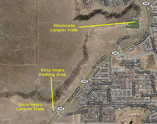
That left the Rinconada Canyon Trail system right here at the Visitor Center and the Boca Negra Canyon (Black Mouth Canyon) trail system that was a mile or so back south along Unser Blvd. In fact, we'd passed it on the way up. We were told that it was in Boca Negra Canyon that you could get closest to 300-400 of the most intricate petroglyphs (the entire monument containing perhaps 20,000 of them. So what we decided to do was walk a bit of the trail system here at the Visitor Center and then, since we had to go that way anyway, we would go to Boca Negra Canyon.
The Trails and the Petroglyphs
|
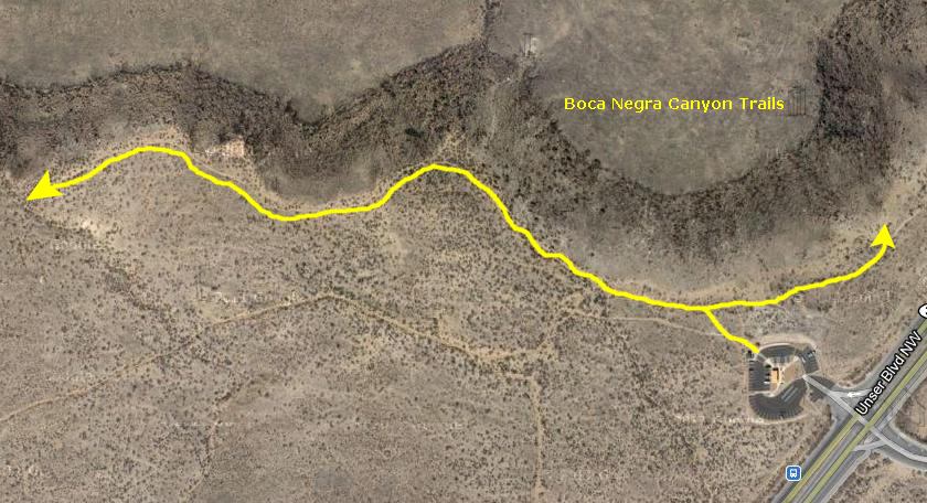
It's actually hard to picture what the ridge was like from the aerial view at left. From the ground, it was basically a long, winding ridge composed of jumbled black rock- hence the "Negra" part of the canyon's name. The trail actually wound along the base of this ridge of rocks, close enough that you could see a great many petroglyphs, and with little side pathways where you could get right up beside most of them. So that made it a great hike, in that you didn't have to view everything from a distance.
Although it was quite warm, there was something of a breeze, and there was always the view back towards Albuquerque to provide a vista. And, of course, since you were never out of sight of the city, it was impossible to get lost. Years later, when Fred and I hiked in the mountains above Palm Springs, we were in another situation in which if you looked in one direction, you would think you were in wilderness, but if you looked behind you, civilization was right there next to you.
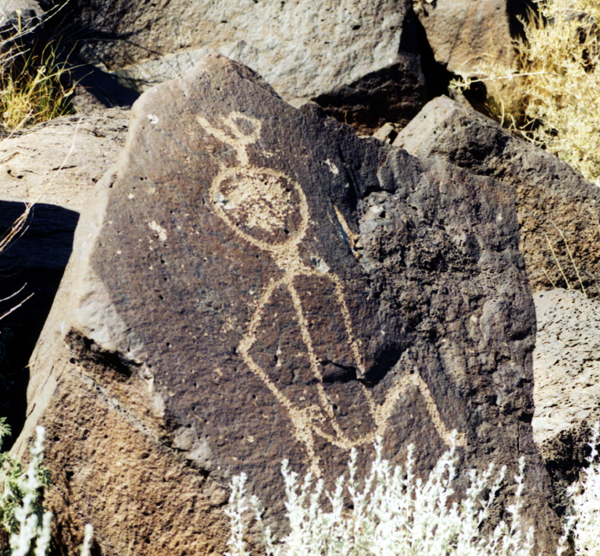
So, we headed off on the trail that led from the parking area over to the base of the ridgeline. There, at the trail intersection, we went both ways. First, we took a northern route and, along the way, encountered and photographed a great many very interesting petroglyphs, including this one of a man with a raised arm. We've seen this same kind of image numerous times; perhaps the raised arm is a greeting. This particular petroglyph appeared to be horizontal, but I would guess that it was originally carved vertically, but that the rock was later moved or fell by itself.
|
I've selected twelve of our best pictures to put in the slideshow at right. The first five were taken along the first part of our hike, and Fred took the last seven when he went off exploring on his own for a little while.
To view the slideshow, just click on the image at right and I will open the slideshow in a new window. In the slideshow, you can use the little arrows in the lower corners of each image to move from one to the next, and the index numbers in the upper left of each image will tell you where you are in the series. When you are finished looking at the pictures, just close the popup window.
Petroglyph National Monument was really interesting, and I KNOW that Fred really enjoyed it. Now we'd be heading to some spectacular scenery in El Malpais National Monument.
You can return to the page index or continue on to the next section.
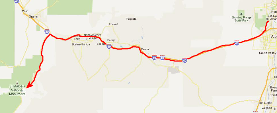
The El Malpais National Monument
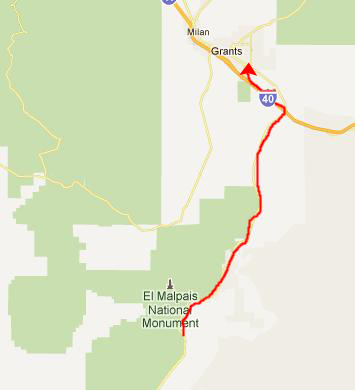
Getting to the El Malpais NM
|
El Malpais National Monument
The El Malpais is part of the Zuni-Bandera volcanic field, the second largest volcanic field in the United States. This rugged pahoehoe lava flow filled a large basin rimmed by higher sandstone bluffs, now large wind and water rounded, and lighter colored contrasting landforms that surround much of the darker malpais. The park has many inactive volcanoes, some potentially active volcanoes, and also some geothermal activity.
|
In the area known as "the Narrows" the cliffs rise up as a fortress, then around the bend have cracks and fissures formed by water that have calved off chunks that lie on the ground or propped against the walls. Further on the road opens to the more weathered ancient lava, that now can support small trees and shrubs.
A hiking trail leads from the Narrows picnic area leads to the rim of the mesa bluffs and another panoramic view. The Cerro Encierro is a hill with hiking and climbing routes that provide more spectacular views. Where the terrain is predominantly bedrock and large rock formations trails cannot be defined in the usual ways, so sequences of stone cairns are used to indicate the route.
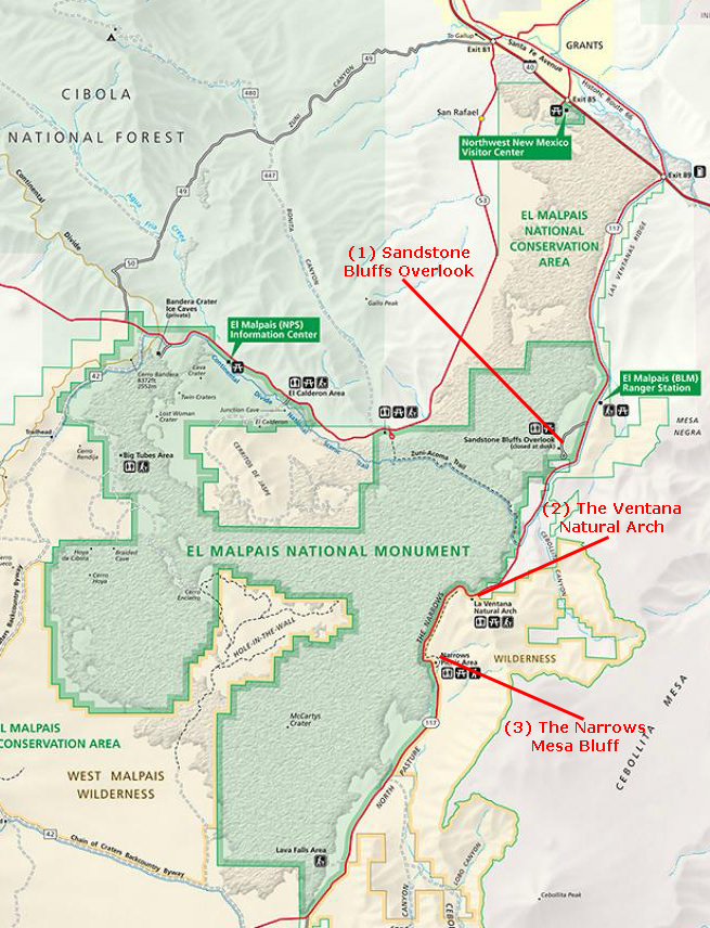
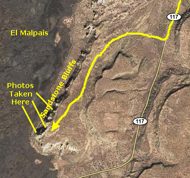
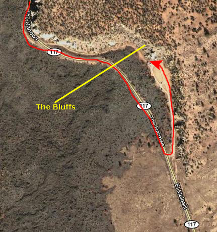
This afternoon, we're going to make three stops here on the east side of the National Monument (saving the lava caves, which are on a highway west of here, for tomorrow). We'll stop first at the eastern high bluffs to look out over the volcanic field, then we'll visit the Ventana Arch, and finally we'll hike to the top of the mesa bluffs at The Narrows. You can see these three stops marked on the park map that I have put in the scrollable window at left.
(1) The Sandstone Bluffs Overlook
|
|
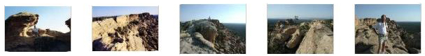
When we parked, we walked right over to the top of the sandstone bluffs to our right where we could indeed see an almost unlimited distance to the west- almost all of the vista being the barren vocanic fields. Below are thumbnails for some of the best of the pictures we took here; click on those thumbnails to view:
|
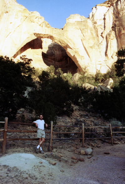
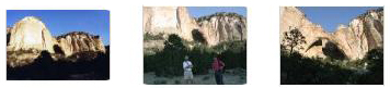
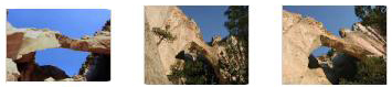
(2) The Ventana Natural Arch
|
|
It's too bad that, from the air, you can't really see the arch. Even if the aerial view above had been taken in the afternoon, so that the arch wouldn't be in shadow, we'd be looking at it from the top, and it would blend in to the cliff to which it is adjacent. On the aerial view, I've approximated the short path up to the arch.
|
|
|
|
|
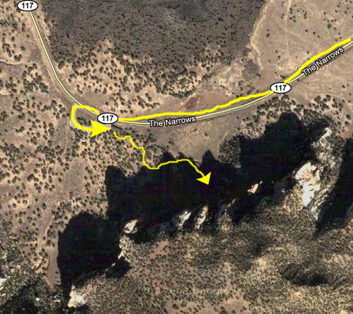
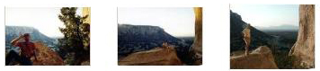
(3) Mesa and Bluffs at "The Narrows"
|
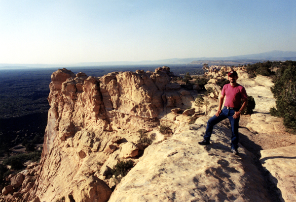
From the parking area, it was a twenty-five minute hike up to the top of a mesa that offered pretty amazing views. In the fading light, we took only a few pictures here, two of which were good. As soon as we got to the top of the mesa, Fred had me stand on the edge of the mesa while he took a picture of me. The picture looks south back across the parking loop, and you can have a look at that picture here.
After that, we both walked along the top of the mesa heading north and west, looking at the expansive views to the south and west. After a few hundred feet, I stopped to look back again at the view to the south, and got an excellent picture of the edge of the mesa cliff; you can have a look at that picture here.
That was it for El Malpais National Monument this afternoon. We turned back north on NM 117, heading for Grants, NM.
|
|
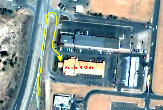
We had a good dinner at a local restaurant (getting our recommendation from the desk clerk at the Super 8, and then turned in for the night.
You can return to today's index
or use the links below to continue to the album page for different day.
|
June 23, 2003: Western Trip, Day 3 |
|
June 21, 2003: Western Trip, Day 1 |
|
Return to the Index for Our Western Trip |