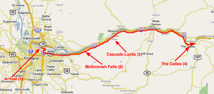
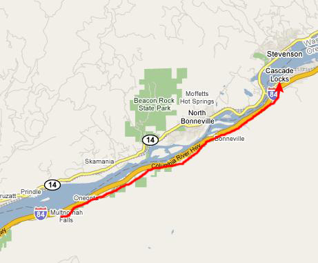
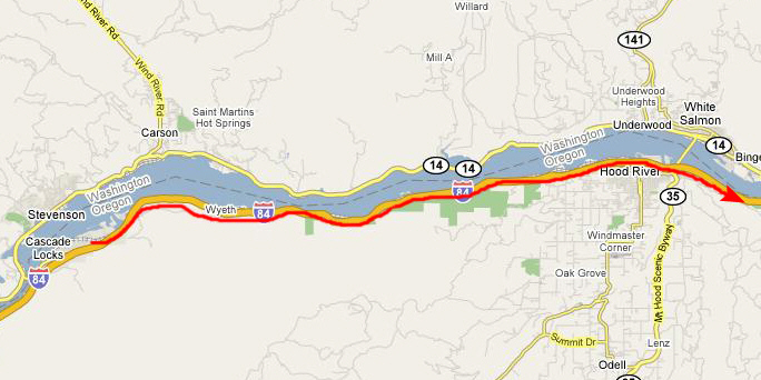
Day 1 Route Map
Let's take a look at the route we'll travel today:
We'll be arriving in Portland a little before noon, and then picking up our rental car and heading over to I-84 East. The Interstate follows the Columbia River eastward, and we'll be making our first stop at Multnomah Falls, which is right on the Interstate. The next stop will be the small town of Cascade Locks, where there is a bridge over the Columbia that is supposed to be very scenic. Then, we will continue east through Hood River and finally end for the day in The Dalles, where we have a hotel reservation for the night.
The flight from Dallas was quite nice; those emergency exit rows make all the difference. We arrived just after lunchtime in the
new American concourse
at Portland International. Because of security restrictions, we'd checked our two large bags, so we had to go pick them up and then find the rental car shuttle.
As we headed down to baggage claim, I took a short movie of the concourse, and you can watch it with the player at left.
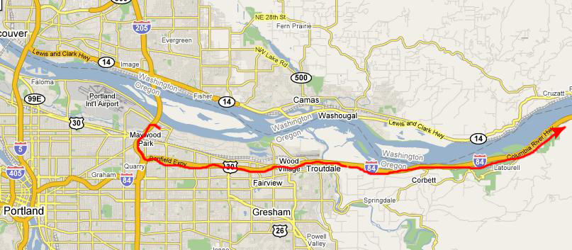
The rental shuttle took us to a location off the airport where we picked up our car. I've been here before, so I knew my way around. We had some lunch and then jumped on I-205 south to pick up I-84 east, and then we headed east from Portland along the Columbia River gorge. The river was pretty scenic, but we knew we'd be stopping at Multnomah Falls shortly, so we held off on pictures until then.
The drive from Portland to our first stop along I-84 East, Multnomah Falls, was very scenic. While it widens out quite a bit near Portland, the Columbia River Gorge is a good deal narrower upstream, and by the time you leave the Portland suburbs behind, it is one of the most scenic river channels in the country.
Multnomah Falls was about a twenty-mile trip from the Portland Airport. There is not much room on the mountainsides south of the Columbia River for Interstate 84, and so the exit for Multnomah Falls had to be done a bit differently. As you are going east (or west, for that matter), you find that the interstate median widens just enough to enclose
the parking area for Multnomah Falls,
and there is an underground passage over to the south side of the eastbound lanes where the entrance to the viewing area can be found (as you saw in the picture).
We exited the highway into the parking area and found a space. Then, just before we headed through the underpass to get to the base of the falls, I made a movie looking all around at Multnomah Falls and the Columbia River and the fantastic scenery, and you can watch that movie with the player at right.
Then, it was off to the base of the falls.
As soon as we came out from the underpass, we got spectacular views of the falls ahead of us. There was a broad walkway up to the viewing area at the base of the falls, which was also the starting point for a paved trail that lead through the forest on the right-hand side of the falls up to an observation bridge about one third up the height of the falls.
We took lots of pictures at this point, and I have put thumbnails for the best of them below. To view the full-size images, just click on the thumbnails:
(Click on Thumbnails to View)
When we got to the end of the broad walkway, we had wonderful views looking up at the falls, although it was impossible to get it all in from here, we were so close. I did use my zoom lens to take a picture of our next stop on the falls hike-
the viewing bridge
that crosses in front of the falls about a quarter of the way up. The falls seems to have two stages, the topmost being three or four hundred feet high, and then this thirty or forty foot
lower cascade.
Before we headed up to the viewing bridge, I made a movie of Multnomah Falls from its base all the way to the top, and you can watch that movie with the player at left.
After a short hike up and around through the forest on an easy paved trail, we reached the viewing bridge suspended over the lower portion of Multnomah Falls. Here, we could get an excellent view of the
lower observation area
that we just came from, as well as the parking area and highway beyond. The bridge itself was pretty crowded, so we waited off to the side where I made a movie starting with Fred on the observation bridge and panning up the height of the falls. You can watch that movie with the player at right.
On the other side of the viewing bridge, we found that the trail to the top of the falls began with a
stone stairway,
and so we started climbing.
The trail was not difficult, but it was a bit steep in places, and we did not encounter too many other people on it. Partway up, there was an overlook that offered a good view of
the Columbia River
and the highway far below.
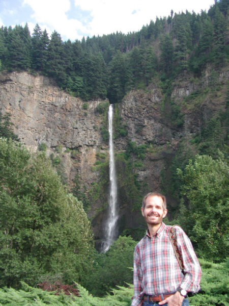
After about thirty minutes on the trail, we reached the uppermost viewing area and overlook, where we paused just to take in the view. I made an attempt at a humorous movie here, this one of the stream going over the falls, but it didn't turn out to be as humorous as I thought. Even so, you can watch it with the player at left. Fred and I also took turns taking pictures of each other with the Columbia River as a backdrop; you can see my picture of Fred
here
and Fred's picture of me
here.
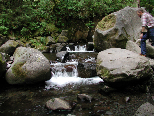
We stayed at the overlook for a while, but we found that the trail continued up alongside the stream that fed the falls, and so we went on up that trail a ways. It led us maybe a quarter-mile through the forest, following the stream and, at one point, crossing a
beautiful stone bridge
to bring us out at another
small waterfall
dropping into a beautiful tranquil pool.
I made a movie of that waterfall and its pool, and you can watch that movie with the left-hand player below. As we find to be true on so many hikes, we could easily have followed the rocky stream (see a movie of it with the right-hand player below) all all afternoon, going further and further back up into the mountains, but we had other things to do.
Multnomah Falls and Pool
The Stream that Forms the Falls
So we reluctantly turned around and headed back. When we got to the stone bridge, I made a movie of it, and you can watch that movie with the left-hand player below. When we got back to the upper overlook itself, we were by ourselves, so I could take a movie of the Columbia River from there, and you can see the result with the right-hand player below:
The Stone Bridge on the Falls Trail
The Columbia River from the Multnomah Trail
And, finally, as we came to the bottom of the trail near the observation bridge, Fred found a clearing in the trees where he could get a good view of the
observation bridge,
showing the trail on the far side back down to the parking area.
Multnomah Falls was really pretty, and we assumed that it would be only the first of many beautiful and interesting places we might see in the next week.
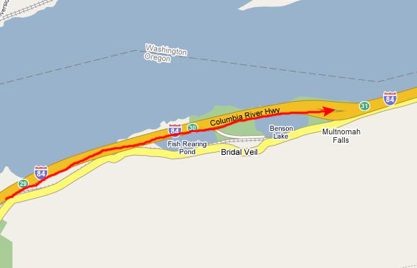
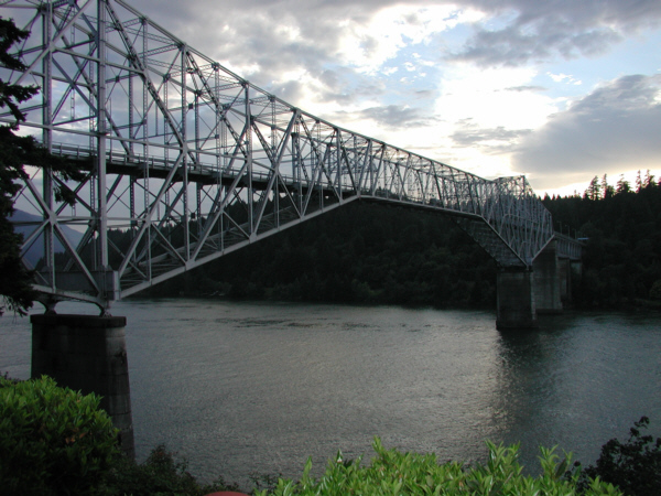
We got back in the car and continued east on the interstate towards Hood River and after another thirty miles saw the exit for Cascade Locks. The sign said there was a bridge across the Columbia River to the state of Washington, and we wanted to see what it looked like. So we followed the exit to US 30, went under the bridge approach and stopped at a general store just beyond the bridge to get out and take a look.
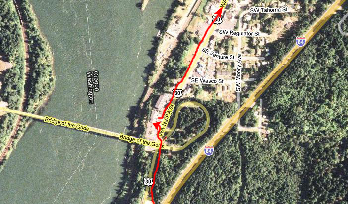
This aerial view of the immediate area will show you where we got off the interstate and where we parked just inside the town of Cascade Locks. We didn't want to take the time to actually cross the bridge into Washington although, in retrospect, maybe we should have- just to get some pictures.
When we got out of the car, we were in a parking area just northeast of the bridge and in a perfect spot to get an excellent view of
the Bridge of the Gods
(probably so named because of the spectacular scenery all around). We walked towards the bridge and, when we got to the support pillars, we could see that they were decorated with what looked like
Indian paintings-
these depicting scenes involving Lewis and Clark, I think. This decoration was certainly better than the normal graffiti. From directly under the bridge, we could look
east up the Columbia,
with the steel trusses of the bridge framing the scene.
From the other side of the bridge, I stopped to make a movie of the bridge and of the Columbia River nearby. You can watch that movie with the player at left.
We stayed here for a bit, admiring the scenery, and then walked back towards the general store. Outside along the riverbank, there was a picnic area that offered another good view up the Columbia, and I made another movie. You can watch it with the player at right.
While I was doing that, Fred had walked back to the parking area and when I caught up with him, I found him conversing with some other tourists. That two groups of tourists might be talking to each other wasn't unusual, but the fact that Fred was one of the groups was indeed unusual. I don't know how the conversation between Fred and the tourists from Alaska got started, but it had already turned to Presidential politics (this being an election year) and Fred had found the family to be kindred spirits. You can watch a movie of part of the conversation with the player at left. We all chatted for a while, and then Fred and I headed on east along US 30 through the picturesque town of Cascade Locks.
We got back on the Interstate east of Cascade Locks and had driven another ten miles or so in the fading light when we saw an exit for a scenic overlook. Since the light was going, we decided to stop and see if we could get some final pictures. I am glad we did, for I was able to get one of the best pictures of the entire trip. It was a
beautiful sunset
but, more than that, it was the sun setting over the Pacific Ocean, by now over a hundred miles away, as seen from the Columbia River Gorge. It was very ethereal. The movie I made of it really didn't do it justice either, but you can watch that movie with the player at right.
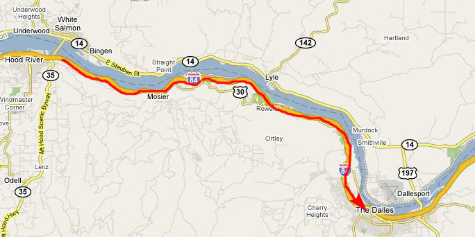
Now we just drove along, as the interstate paralleled the Columbia River, and we were never out of sight of it. We passed through Hood River, Oregon, heading on east.
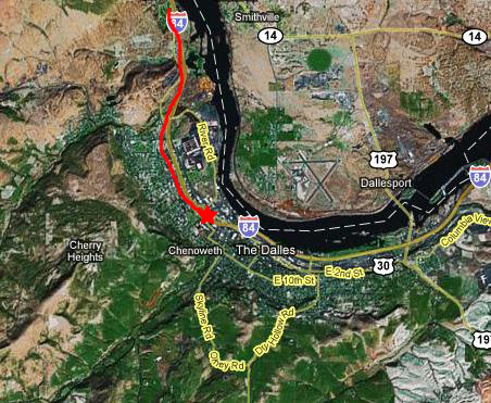
About 90 minutes after leaving Cascade Locks, we came to the outskirts of The Dalles, Oregon. Earlier in the day, we had called and made reservations at the local Super 8 Motel, so now all we had to do was find it.
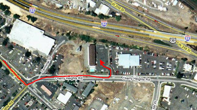
As it turned out, the Super 8 Motel was on the west side of town; I thought it would have been further, and we had to double back at one point.
We finally did find the motel, and got checked in fine. We ate dinner at a local place recommended by the girl at the front desk of the hotel, and we also stopped at the local Wal-Mart to pick up a cooler and some snacks and drinks to consume along the trip. Then, after a long day of traveling, it was off to bed.