July 18, 2004
Oregon Trip Day 2 A Day in Southern Washington
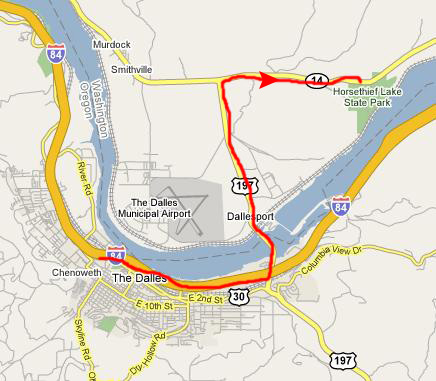
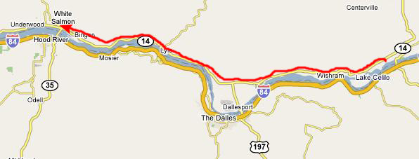
Crossing the Columbia River into Washington State
We begin our second day of this Oregon trip by leaving Oregon for a while. There are a number of things we would like to do in extreme southern Washington State, on the other side of the Columbia River, and so first we must cross the river here at The Dalles. To do so, we went a bit further east on I-84 and exited for the road across. We stopped just before climbing up onto the bridge to get a view of
the Dalles Dam,
which is important because when it was built in 1956, it created a lake upriver (the Columbia actually being a series of long lakes throughout much of its length). The lake it created, Horsethief Lake, actually submerged a large number of ancient petroglyphs, some of which were rescued and moved to the State Park with the same name- a visit to which will be the first of the things we want to do in southern Washington.
Then we headed on across the Columbia River. I made two movies as we crossed (while Fred was talking on the phone to somebody), and I think you may find them interesting. You can watch them using the players below:
Columbia River Crossing (Part 1)
Columbia River Crossing (Part 2)
When we got to the Washington side, we stopped at a scenic view point. From that point, we could look back at
the bridge we crossed
and we could also get our first clear view of
Mt. Hood-
the highest point in Oregon and one of the stops we will make tomorrow. When we were done at the overlook, we drove another two or three miles north to pick up Washington Route 14, which we took east to Horsethief Lake State Park.
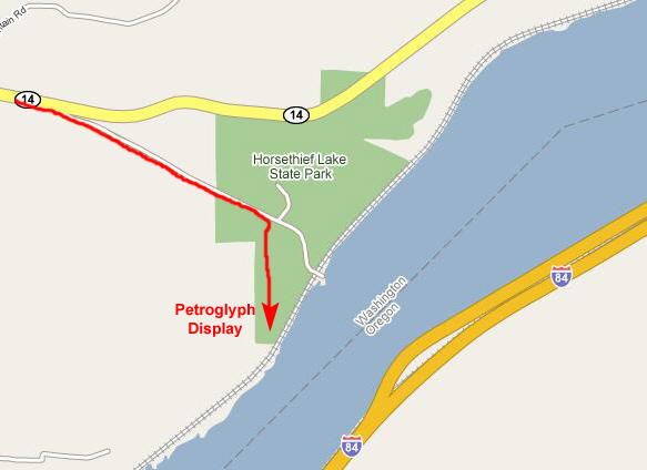
When we arrived in the parking area, we found that the area where the
petroglyphs are displayed
was fenced off; you could not get very close to them, but you could still see them clearly, photograph and film them.
But from the top of the trail near the parking area, I walked along the fence line and made a movie of the petroglyphs on display, and when I got to the end of the fence line, I made another movie showing not only the petroglyphs but the view towards the Columbia River as well. You can watch both these movies with the players below:
Walking Along the Petroglyphs
The Petroglyphs and River Setting
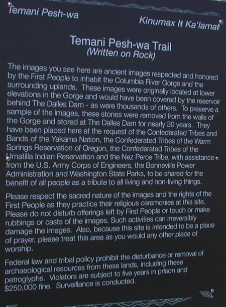
As you can read on the sign at the entrance to the Pesh-wa Trail, these petroglyphs are not all from this area, or even from known areas. Most of them were moved here when the dam at The Dalles flooded the shallow canyon where they had been originally created. One petroglyph of them is from an area just to the West of the current exhibit is and one pictograph and one petroglyph are from Miller Island. The remaining petroglyphs came from Petroglyph Canyon, which is about one mile upriver from this spot.
The 10-acre basalt lava cliffs of Petroglyph Canyon contained perhaps the greatest concentration of rock imagery in the Pacific Northwest. It is unknown why these particular petroglyphs were chosen to be removed from among the thousands left behind, but they have been marked to indicate the cuts prior to being removed from the cliff at Petroglyph Canyon. They were removed from three distinct areas in Petroglyph Canyon- areas referred to as the Upper Wall, Mound in the Middle and the Lower Wall.
These petroglyphs
were originally found clustered in a group and they have been placed here in their original grouping and as close as possible to their original orientation and relationship to one another.
From 1957 to 1974 these rock images were stored at various locations at The Dalles Dam. From 1974 to 2003 they were stored under the fish ladder at The Dalles Dam in a gravel-fenced area. It has long been the desire of the four Columbia River Treaty Tribes that these petroglyphs be returned to an area respectful of their heritage and near where they had stood for thousands of years. In 2003, this was accomplished by a group of dedicated people. Because the area was fenced, we could not get very close to the petroglyphs, but we did take a couple of pictures with our zoom lenses that turned out well, and you can see those pictures
here
and
here.
Petroglyph Canyon is now underwater in Horse Thief Lake. The underwater area is now a registered National Historic Place, significant to the native peoples of the area, and also as an area noted by Clark during the Lewis and Clark Expedition. On the Historic Register site the pictographs are listed as dating from 1000-1500 AD. There are hundreds of petroglyphs underwater. Only a few were saved, and they are now located at this historic site of the people of Wishram Village. Apparently, since we visited in 2004, this park has been re-named Columbia Hills State Park, although Google maps still has the old name. I have not been able to verify when the name was changed and/or whether it is official.
Lewis and Clark stayed just upriver from here in 1805, and Clark wrote this in his journal: "I returned through a rockey open country infested with pole-cats to the village where I met with Capt. Lewis the two old Chiefs who accompanied us & the party & canoes who had all arrived Safe; the Canoes haveing taken in Some water at the last rapids. here we formed a Camp near the Village, ..." [Clark, October 24, 1805]
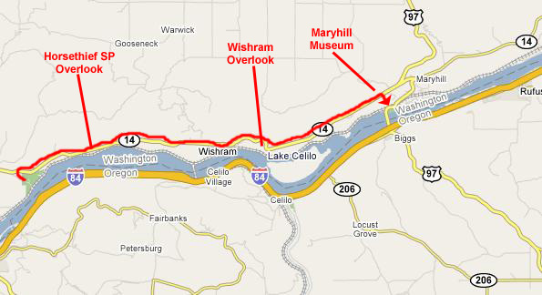
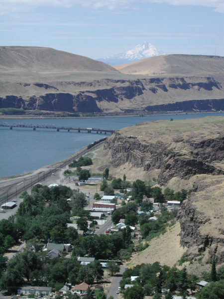
As we left Horsethief Lake State Park, I took a look back up towards the highway at the
desolate landscape
that is the norm in this part of Washington and Oregon. It really hadn't dawned on me until we got to the state park how much different the terrain was from our stops last night at the falls and the Bridge of the Gods. The trees seem all to be gone, replaced with something much like desert. We headed back up to the highway and continued east, and when we got around the bend in the river, there was an overlook where we could stop and look back at
Horsethief Lake SP
(the wooded area in foreground) and the site of the petroglyphs beyond.
I also took a movie from this spot, panning around from the hillside we were driving on, past the state park, and taking in the Columbia River- including the area that is now the submerged Petroglyph Canyon. I know the wind messed up the sound some, but you can watch that movie with the player at right.
A bit further up the road, before the riverside town of Wishram, there was another overlook, and this one offered a beautiful view of
Mt. Hood,
so Fred used it as a backdrop for a picture of me. Look at the inset picture at left and you'll see what I mean about a beautiful view.
Next, we passed above the
town of Wishram,
built at the same site as the old American Indian village, and stopped at an overlook where we could get a good view of it. This town is very interesting, in that it seems to be an oasis down at river level, with only one main road down to it. I can only assume that the town uses river water for irrigation. From the same overlook, we could look at good ways
up the Columbia River
towards the next big town (and bridge across the Columbia)- Maryhill. I also took a movie from this spot, and you can watch that movie with the player below:
The history of the Maryhill Museum of Art is inseparable from the life of its founder, Samuel Hill. Born in 1857 in Deep River, North Carolina, Hill grew up in a Quaker family and at the age of eight the family moved to Minneapolis. After graduating from Haverford College, with subsequent study atHarvard University, Hill practiced law in Minneapolis and in 1886 became a law clerk for the Great Northern Railway. Hill became a trusted advisor to the company�s president and two years later married his boss�s oldest daughter, Mary. The two had a daughter, Mary, and a son, James.
Hill became president of the Seattle Gas and Electric Company�owned by Minneapolis investors�and in 1899 moved to Seattle. His wife and children later joined him, but returned to Minneapolis after only six months out West. A successful businessman and entrepreneur, Hill quickly became well known among the political and social elite of the Northwest. He served as president of the Washington State Good Roads Association and spent much of his life promoting the development of roads throughout the Northwest and lobbying Washington and Oregon legislators for funding.
It was Hill who was the catalyst behind the Columbia Gorge Highway. His dream was to �build a great highway so that the world can realize the magnificence and grandeur of the Columbia River Gorge.� In 1907, Hill purchased 6,000 acres of land along the Columbia River with the hope of establishing a Quaker farming community. He formed the Maryhill Land Company, named after his daughter, and set about building a town. The village included a store and post office, a Quaker church, an inn, a blacksmith�s shop and a stable. In 1914, work began on
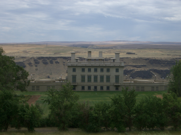
a hilltop mansion
that was to be Hill�s home, but the remote location of Maryhill and the lack of irrigation proved insurmountable obstacles and the land company failed. Construction of Hill�s mansion stopped in 1917.
A friend of Sam Hill�s, Lo�e Fuller, a pioneer of modern dance in Paris, convinced him to turn his mansion into a museum of art. Through her close association with well known artists in France, she helped obtain an impressive collection, including more than 80 works by French sculptor Auguste Rodin. Hill also transferred his own art collections to the museum. In 1926, Hill asked another friend, Queen Marie of Romania (granddaughter of Great Britain�s Queen Victoria), to visit and dedicate the museum. Although still unfinished, the museum was dedicated by the queen in a ceremony that received national attention and was attended by more than 2,000 people. In 1931, Hill, on his way to address the Oregon legislature on behalf of the Good Roads Association, became ill and died three weeks later at the age of 73.
Litigation over Hill�s estate delayed progress on the museum, which was filled with unpacked crates of art. In 1937, Alma de Bretteville Spreckels, the wife of San Francisco sugar magnate Adolf Spreckels and a friend of Hill�s, took up the task of finishing the museum. She was elected to the newly-formed board of trustees and donated artwork from her personal collection. Under her guidance, the museum was opened to the public on Sam Hill�s birthday, May 13, 1940. Now, in addition to the artwork, there are large sections devoted to the natural and Indian history of this area of the Pacific Northwest.
The
entrance to the museum
was on the east side of the old mansion, and of course we purchased entrance tickets and spent quite some time touring through the home. Flash photography was prohibited in the Museum, and none of the pictures we took without it were much good. I was able to take movies, however, and I have included one movie of of some of the American Indian exhibits; use the player at right to watch it.
Situated in a park-like setting of twenty-six acres, the three-story European, beaux-arts style
concrete mansion
overlooks the Columbia River Gorge and was designed as a residence in 1914 by the nationally recognized architects Hornblower and Marshall. The building is constructed of steel I-beams with interior steel studs. The walls, floors, and ceilings are of poured concrete reinforced with steel. No wood has been used in the structural parts of the building. The recessed windows are a distinctive trademark of the firm. It was placed on the National Register of Historic Places in 1974. The building houses the Museum�s collections, exhibits, program space and staff.
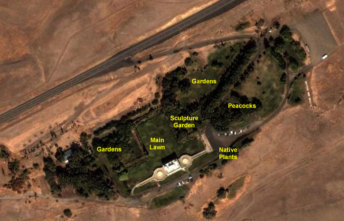
The gardens are an oasis of green within the stark dry landscape of the eastern end of the Columbia River Gorge. Hill purchased the site from the Gillenwaters, and the orchards and vegetable gardens developed by them were part of his farming enterprise. Although never fully realized, early plans included formal gardens in the European style.
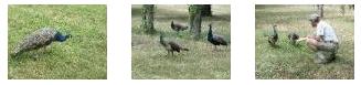
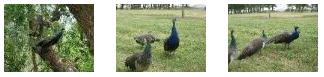
Today the park includes the Grand Lawn, shady picnic hrounds, the east lawn, the Sculpture and Rose gardens, the Lewis and Clark Overlook and Native Plant Garden, the North Lawns and Entrance Drive. The grounds are home to a wide variety of wildlife, including flickers, crows, turkey, quail, black birds, raptors, fox, raccoon, and an occasional coyote or bobcat. The site is an official site on the Lewis and Clark National Historic Trail. There are also a flock of peacocks.
The peacocks were added in the late 1970s to the delight of its visitors each year; you can watch a movie of them with the player at right. We also took a number of still pictures of the peacocks, and I have put thumbnails for some of them below. Just click on the thumbnails to view the full-size images.
(Click on Thumbnails to View)
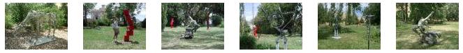
Jeffrey Weitzel's piece,
The Grace Blue,
forms the centerpiece of the outdoor sculpture collection. It sits on
the river side of the museum
(just outside this picture, across the walkway to the left). But most of the other sculpture pieces are in the
sculpture garden
in front of the museum. I took two movies out in the sculpture garden, and they will give you an idea of what the area was like; you can watch those movies with the players below:
Behind My Garage
Alongside My House
There were maybe ten really interesting sculpture pieces sprinkled around the garden, and we took lots of pictures of them. I've selected six of the best of these and have included thumbnails for them below. Click on the thumbnails to view the full-size images:
(Click on Thumbnails to View)
The Lewis and Clark Overlook and Native Plant Garden sits on a point at the museum's eastern edge where its lush gardens meet sagebrush ranchlands. This dramatic setting affords visitors vast
panoramic views
of the Columbia River Gorge, surrounding plateaus, and majestic Mt. Hood. The view was really spectacular, and both Fred and I took movies standing on the southern lawn of the mansion right next to the river. You can use the players below to watch them:
Fred's Movie
My Movie
There is also an accessible
winding pathway
taking visitors through the museum�s native plant garden highlighting plants collected by Lewis and Clark�s Corps of Discovery on their journey in 1806 � 1806. The garden also features interpretative panels on the history Maryhill Museum of Art, its 6,000 acre ranchlands, and regional attractions.
Maryhill was really an interesting place, very much an oasis in the stark terrain all around and as we left out the main drive and got back to the highway, we could look back on the
mansion overlooking the Columbia River.
When we left Maryhill Museum, it was getting towards lunchtime, so we went back to Horsethief Lake to take advantage of the picnic area in the park to have our lunch. While
Fred had lunch
we talked about where we might go next, and we settled on what the Internet said was one of the nicest waterfalls in this area- up by Mt. Adams. I also walked around the area where we were eating; there were beautiful view of
the Columbia River.
While we were here, I made a movie of Horsethief Lake State Park before we got back in the car and drove westward along Route 14, passing the bridge to The Dalles and heading along the Columbia River (on the north side this time) towards the town of White Salmon. I made another movie while we were driving along the Columbia River. You can watch both these movies with the players below:
Horsethief Lake State Park
Driving Along the Columbia River
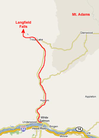
When we got to White Salmon, we turned north on Washington 141 towards the town of Trout Lake. As we had been driving towards White Salmon, the terrain had changed again and we had left the barren dry terrain behind in favor of a greener, more wooded landscape. North of White Salmon, the heavy forest returned, and we passed through an area of farms and lush greenery.
About halfway to Trout Lake, the imposing peak of
Mt. Adams
began to dominate the horizon, growing larger as we headed north. Just before entering the town of Trout Lake, we found an unusually good view of
farms and Mt. Adams-
still snow-covered this late in the summer. I suppose locals get used to the view, but for we city kids from an area as flat as North Texas, it was something to behold.
About twenty-five miles north of White Salmon, we entered the town of
Trout Lake,
where we stopped to ask directions to Langfield Falls. We knew we'd have to travel on Forest Roads for a ways; there are no actual state roads that go any further (nor are there any state roads that go west from here; Mt. St. Helens is in the way). But we got some good directions and headed off.
It took about six miles and one wrong turn before we found the right road to the falls, but we have certainly done a lot worse.
The trail to Langfield Falls began off a forest road about seven miles northwest of Trout Lake. There were a few other cars in the parking lot, so we expected to see other hikers. The trail itself was only about a quarter-mile, and we could hear the falls way before we could see them. On the way up to the base of the falls, Fred took two movies, intended to be watched in sequence, and you can watch them with the players below:
Movie 1
Movie 2
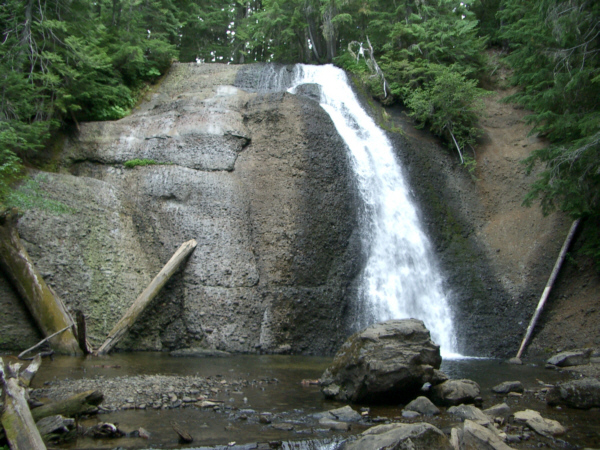
As with most waterfalls, there was a pool at the base of
Langfield Falls,
and I went off to explore it while Fred was snapping some other pictures.
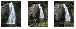
Both Fred and I took a number of pictures of the falls, and I have put thumbnails for three of them below. You can see the full-size images by clicking on the thumbnails:
(Click on Thumbnails to View)
I found that there was a continuation of the trail that led up and around and to the top of the falls, and so of course I had to troop up there to see what the view was like. These falls are not very high, so it wasn't a dangerous trip, and the view was nice down to the pool.
I took two movies here at Langfield Falls. The first was from the base of the falls, where I panned around to show Fred up above me taking his own pictures. I also made a movie from the top of the falls, showing the stream that feeds the falls going over the precipice. You can watch both those movies with the players below:
Langfield Falls from the Base
From the Top of Langfield Falls
We spent maybe an hour hiking to the falls and back, and then we set out to head over to Mt. St. Helens.
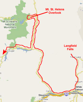
Getting to a point near Mt. St. Helens was not direct; there is no paved highway from Trout Lake over to the west, so we had to go back twenty miles to White Salmon, west along the Columbia to Carson, and then north on Wind River Road towards the national monument. Just southeast of the park, we could take another state highway north for a few miles and then turn into the access road for the Mt. St. Helens National Monument.
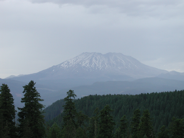
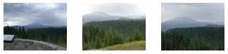
This road offered a number of scenic views of
Mt. St. Helens
along the way. Presently, we reached an overlook that gave us some more good views and also had a number of explanatory signs detailing what had happened when Mt. St. Helens blew up in 1996. It was interesting to read all about the event. While we were here at the overlook, I made a movie of the overlook, Mt. St. Helens and the surrounding area, and you can watch that movie with the player at left.
We had thought about driving on to Spirit Lake (formed after the explosion), but it had started to rain lightly, and we thought that picture-taking possibilities would just deteriorate from here, and so we contented ourselves with just sitting and looking at the mountain for a while. We did take a number of other pictures; even the few I have selected to include here are much the same. But you can look at as many of them as you wish by clicking on the thumbnails below:
(Click on Thumbnails to View)
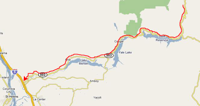
After we spent some time here at the overlook, we headed back out of the national monument area and back down the highway to Wind River Road. At that junction, it becomes Washington Route 503, and we took that west towards Woodland, Washington.
From Mt. St. Helens, we went south to pick up Washington Route 503 and took that west until it intersected with Interstate 5 in Woodland, Washington.
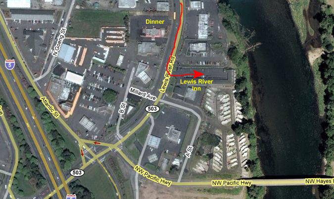
When we got to Woodland, we started looking around for a place to stay, and luckily found a very nice place- the Lewis River Inn. It was, as you can see, right on the bank of the Lewis River.
We got settled in the room and relaxed for a while, and then got a recommendation from the desk clerk for a nice local place to have dinner.
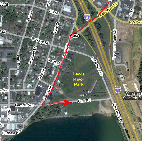
It was still somewhat light when we finished with dinner, so we drove under the Interstate to the Lewis River Park on the other side. It was a nice evening, and we enjoyed wandering around the park before heading back to the hotel.