|
July 20, 2004: Oregon Trip Day 4 |
|
July 18, 2004: Oregon Trip Day 2 |
|
Return to Main Index for Oregon Trip Pictures |
|
Oregon Trip Day 3 July 19
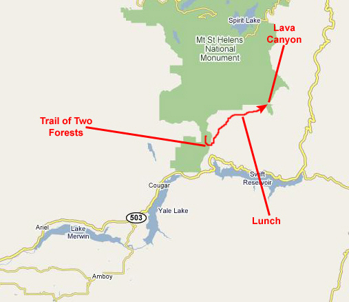
Ape Cave (Mt. St. Helens) |
Sometimes, we are pretty good at planning our trips, and we end up doing just what we thought we would just when we thought we would. But other times, we find that our plans change- usually because we find out about interesting things to see and do that we hadn't known about ahead of time. Spending most of the day today back in Mt. St. Helens National Monument falls into that latter category. It wasn't until we'd gotten close to the area that we found out about these other things to do. So, last night we changed our plans and rewrote the itinerary for the remainder of the week so that we could spend most of the day here.
I expect that these three things, plus the time it will take us to get there and then on to our next stop, will take pretty much all day, but we shall see.
Touring Ape Cave in Mt. St. Helens National Monument
Needless to say, all of the geology of the sites we will visit today has been created by the volcanism of Mt. St. Helens, and much of it has been altered in the last twenty-five years. Ape Cave is, in fact, a huge lava tube, although it was not created in the 1980 eruption. The Trail of Two Forests winds through numerous tree molds, formed when trees that had been covered by lava burn and erode away although, again, these molds were created before the last explosive eruption. Lava Canyon existed before the 1980 eruptions, although portions of it were re-formed during that great eruption.
Ape Cave lava tube, which formed in one of the Cave Basalt flows about 2,000 years ago, is the longest lava tube (12,810 feet) in the conterminous United States, and one of the longest in the world. During the summer, a national monument interpretive naturalist leads tours through the lower part of the cave.
Ape Cave was discovered in 1947 by a logger named Lawrence Johnson. The cave was not explored until the early 1950s when a scout troop, led by Harry Reese, lowered a team of scouts down a 17-foot overhang to the cave floor. Leaving footprints where no one ever had, these explorers were able to travel through a pristine lava tube full of fragile formations. Ape Cave was named by the Scout Troop in honor of their sponsor, the St. Helens Apes, a local group made up primarily of foresters who may have adopted an old term used for foresters in the area- "brush apes."
In Ape Cave, and other nearby caves that carried lava for long periods, lava cut downward into the pre-flow land surface, in a process called "thermal erosion". This erosion created
passages with high narrow cross‑sections,
such as this passage that leads from the upper cave down to the lower one. In some cases wall linings gradually closed the tube above the moving lava. creating horizontal partitions and stacked passage levels. In other places, the walls collapsed when the buoyant support of fluid lava was withdrawn, exposing soil baked red by heat from the lava. As the lava level dropped, leaving an opening above the flowing stream, hot gases began to remelt the wall and ceiling surfaces, forming a
dark shiny glaze.
In places, the glaze slumped to form a pleated pattern.
Lava oozing from upper walls and ceilings created stalactites, and globules dripping to the floor created stalagmites. Lava formations are not common in the caves and where they do occur they are usually small and fragile. Lava tubes are frequently obstructed by blocks of solidified rock rafted along in the lava stream. These frequently wedged at constrictions forming jambs of lava blocks or as isolated pieces such as the "Lava Ball" in Ape Cave.
At the end of the eruption molten lava remaining in the tubes gradually drained away, leaving an open cave. Tubes take a long time to cool, as much as two years. During this cooling breakdown of the walls and ceiling begins to occur. Breakdown is caused by contraction-cracking of the cooling walls and ceilings. Cooling lava shrinks up to three percent, leaving the cracks seen today in walls, ceilings, and floors. When this takes place, some areas are unsupported, promoting collapse, and the result is huge
piles of broken lava.
The pieces are usually quite sharp and make cave exploring dangerous if you fall. If collapse extends to the surface, entrances are formed. Not all entrances are collapse related however. Many caves are accessed through skylights. Understanding the process will help in assessing the hazard potential of an entrance.
We took quite a few pictures here, but many are repetitive. I have selected five of the ones Fred and I took to include here, and there are thumbnails for them below. To view the full-size images, just click on those thumbnails:
We explored the cave for an hour and a half before the group turned around at the end of the tube to retrace its path to the entrance. We let the group get ahead and exit the cave first, so that we could get some quiet time to just experience the lower cave. I would have liked to explore the upper cave, but it would have required preparation.
When we reached the stairway up from the lower cave, we stopped to take some pictures. Here is
Fred on the stairway,
and here is a picture of
me at the bottom of the stairway.
Finally, as we were climbing out of the lava tube, I took a picture of
Fred on the outside stairway.
Exploring the cave was really neat, but we were on to our next point of interest.
You can return to the Page Index
or continue on with the next section.
The Trail of Two Forests
Trail of Two Forests is perfectly situated near the bottom of the flow, where the lava still moved but was not hot enough to immediately destroy trees. Here, lava cooled around the trees, which eventually decomposed and left small tunnels, caves, and pits as a testament to the old forest. Sometimes a second advance of lava would cover the already felled trees, leaving perfect molds that can still be seen today. Lava tree and log molds are very well preserved in the Cave Basalt Flow. Some of the caves have log molds intersecting the passages. These molds are easily identified by the pattern of charred wood etched into the basalt.
The second of the two forests is the one that stands today. Interpretive signs do a great job of explaining the story in depth. Conveniently, a
boardwalk
lines the entire route, making Trail of Two Forests accessible to wheelchairs. The boardwalk also protects the fragile forest ground, so please stay on the trail. The one chance visitors have to get off-trail is a chance to crawl through a tunnel, or lava tube, nearly 30 feet long. It's a trip!
Here is
Fred at the beginning of the boardwalk
trail as we began our walk through the two forests. For some scale for the following pictures, I stepped off the boardwalk and knelt down beside
a small tunnel entrance
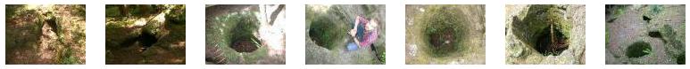
so you could get an idea of how big they are- about the size of a tree trunk, obviously. All along the boardwalk trail, we could see the pits and short tunnels that were left when trees that had been surrounded or covered by lava decomposed and left the rock only (sometimes covered now with moss). We took a number of pictures of these, and I've put thumbnails for some of those pictures below. To see any of the full-size images, just click on the thumbnails:
Over time, the two trees decomposed. Near one end of one tree, a skylight opened up when the thin rock roof collapsed, forming a pit. This let in more water and air and the decomposition process accelerated. At the other end of the other tree, the slope of the land wore away some of the rock (or perhaps the rock never really fully enclosed that tree) and, again, the decomposition was aided by more exposure to the elements and organisms. Eventually, the organic matter of both trees disappeared, and we were left with a long tunnel joined to another tunnel.
The Mt. St. Helens National Monument has supplied a ladder at the site of the skylight to make it easy to drop down the five or six feet to the beginning of one tunnel. From there, one can crawl through the tunnel left by the first tree until one reaches the intersection with the second tunnel. There, one finds additional space and a rock shelf that serves as a bench. From that vantage point, you can look off in a different direction, down the tunnel left by the second tree, and you can see the "light at the end of the tunnel." This second, branching tunnel is a bit smaller, but, still, many people can make it through to emerge at the exit.
To view the slideshow, just click on the image at left and I will open it in a new window. In the slideshow, you can use the little arrows in the lower corners of each image to move from one to the next, and the index numbers in the upper left of each image will tell you where you are in the series. When you are finished looking at the pictures, just close the popup window.
You can return to the Page Index
or continue on with the next section.
Lunch in the Mt. St. Helens National Monument
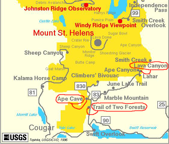
We are going to do three different things today, here around Mt. St. Helens. The first will be to take a tour through Ape Cave, which is in the extreme southern portion of the monument. The second thing will be to explore the tree molds along the Trail of Two Forests, just a bit down the road from Ape Cave. The third thing will be to hike the trail through Lava Canyon, which is at the end of this southern entrance road into the national monument.
Mount St. Helens is one of the most active volcanoes in the Cascade Range. The most recent eruptive episode began on March 20, 1980, after 120 years of dormancy. On the morning of May 18, 1980, following two months of small steam and ash eruptions, the bulging north side of the mountain collapsed, creating an avalanche of rock, mud, and ice which traveled 15 miles down the North Fork, Toutle River Valley. The avalanche was followed by a huge steam explosion which leveled nearly 150 square mi1es of forest and killed nearly everything in its path. This explosion marked the beginning of a magmatic eruption that lasted for the next twelve hours, ejecting nearly three cubic kilometers of tephra, and sending an ash cloud 14 miles into the atmosphere. Ash fell extensively throughout eastern Washington and western Montana and within a month the ash cloud had traveled around the world. Over the next few years, steadily diminishing eruptions built a succession of lava domes on the crater floor, blew them away, and built them again. As the explosions decreased in intensity and degassed lava oozed from the vent, a huge lava-dome nearly 900 feet high grew in the crater. The last lava was added to the dome in 1986; since then only steam emissions have occurred.
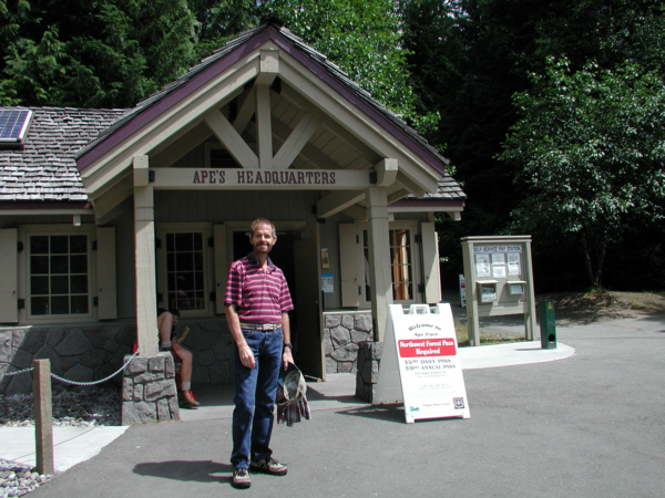
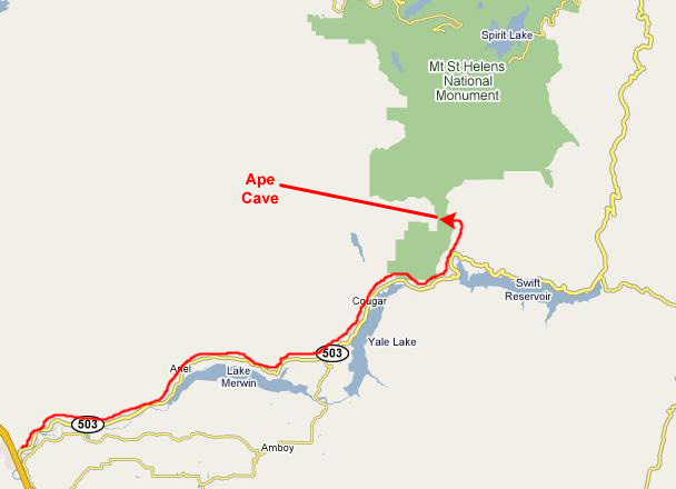
We got up early and checked out of the Lewis River Inn, and then drove back east along Washington Route 503 about twenty miles to the south park road leading north into the Mt. St. Helens National Monument. About five miles up this road we saw the signs for Ape Cave off to the left. We wanted to be in the first tour group so that we would not have to spend any of our day waiting, and we arrived in plenty of time to sign up for that first group.
When we arrived, we signed up for the first tour and about ten minutes later a ranger joined our group and we trooped over to the cave entrance. Before going down into the cave, the ranger supplied a couple of heavy-duty lanterns, and we all gathered around while the lanterns were lit. You can watch this ritual with the movie player at left.
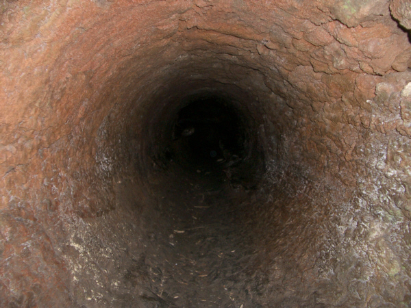
Then, the ranger went through some cautionary comments (watch the movie at right to see what they were) and we were off. A stairway has been built where the old 17-foot drop used to be, and from the top of that stairway we could
look down into the lava tube
itself. We all
filed down the stairway
and the stone steps below it until we were well inside the cave overhang. This formation is actually called a skylight, although this one is at the end of the lava tube (which had caved in a long time ago at this end). Once inside the cave, we could look back at the steps and stairs leading
up through the skylight.
A ways into the cave, the ranger stopped the group to
explain the structure of the cave.
There is a lower cave that we will explore to its end, and an upper cave (we are in it now) that is much longer and requires careful climbing over large rock faces and mounds. The upper cave requires some equipment, so we won't see much of it today. We descended a stairway to the lower cave shortly after our stop, and then walked through the lava tube. You can walk through the lava tube with us using the player at left.
(Click on Thumbnails to View)

The Trail of Two Forests is a quick nature loop into one of the most unlikely natural phenomena in the Northwest. Nearly two millennia ago, Mount St. Helens sent a wave of molten lava down her south flank. This wave of lava consumed everything in its path before eventually cooling and stopping.
(Click on Thumbnails to View)
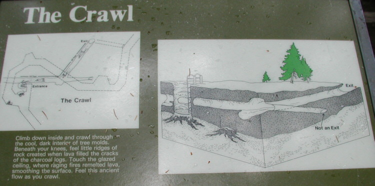
One of the most interesting things about this trail is that visitors have the opportunity (and are, in fact, encouraged) to leave the boardwalk and make their way through "The Crawl." As the sign at the right shows you, this formation came about when lava sheared off two large trees that fell across each other almost exactly end-to-end. When the lava solidified, both trees were encased in rock.
Click on the Image Above to View the Slideshow

This was something we just had to try; we did, and it was a really neat experience. I went first, taking pictures both ahead of me and behind me at Fred following along. Fred, for his part, took pictures looking ahead at my own progress through the formation. With the help of my description above, and the diagram on the sign at right, I think you will be able to follow the pictures in sequence as Fred and I (and, by extension, you) navigate "The Crawl." The pictures we took, pretty much in the order we took them, are in the slideshow at left.
After leaving the Trail of Two Forests, we headed back down the park road to the intersection with the forest road heading north. Before we got there, though, we began to see some incredible flowers growing in patches along the side of the road. We
stopped at the side of the road
to check them out.
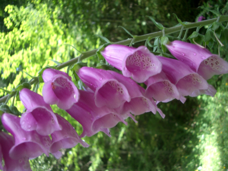
I did not record what we might have decided these flowers were, and I would have no way of looking them up myself (although I might get Fred to do so at some point). In any event, the flowers grew on tall stalks, which made them easy to spot along the road. When you look at them close‑up, you can see that each is a separate pink bell, with an amazing spotted design inside. I am sure that the design only serves the purpose of attracting insects who can pollinate the plant; most such displays of color and design are for that purpose. How that particular design has grown up over time is the amazing part. In any event, the plants were incredibly beautiful.
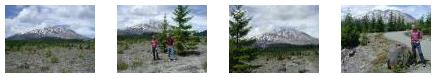
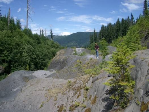
We turned north on the forest road heading for Lava Canyon and, after a few miles, came around the side of Mt. St. Helens that blew up twenty-five years ago. While the area around Ape Cave and the Trail of Two Forests was once again heavily forested and green, this area had only spotty, new-growth trees and some low shrubs and plants. There were some stands of trees (perhaps not destroyed then, or perhaps having grown up fairly rapidly), but in the main this area was a desolate contrast to the green forests earlier. Of course, there were excellent views of Mt. St. Helens itself. Below are thumbnails for four good pictures of this area that we took just before stopping for lunch. Click on them to view the full-size pictures:
|
|
|
 |
The chipmunks were incredibly funny to watch, and we took quite a few pictures of them. Thumbnails for three of these pictures are below; click on them to view the full-size images:
|
I also think you will also find the movie I made of our guest eating a peanut extremely amusing, so be sure to use the player below to watch it:
|
|
|
|
You can return to the Page Index or continue on with the next section.
Hiking Through Lava Canyon From our picnic area, it was another couple of miles until the road ended at the parking area for Lava Falls and the Lava Canyon Hike. Oddly enough, for it being such a nice day, there was only one other car in the parking area, and, also oddly enough, we did not see the other folks anywhere on the trail (although the car was gone when we got back).
|
Removed from the blast zone from the 1980 eruption, Sheep Canyon nonetheless felt a few effects. The eruption created a raging torrent of mud and debris that gushed through the narrow gorge. The violent flow scoured the canyon bottom clean, leaving only barren bedrock for the Muddy River. That was a good thing, as it created a colorful river canyon with numerous pools and cascades. The trail through the gorge is one of the coolest places in Mount St. Helens National Volcanic Monument.
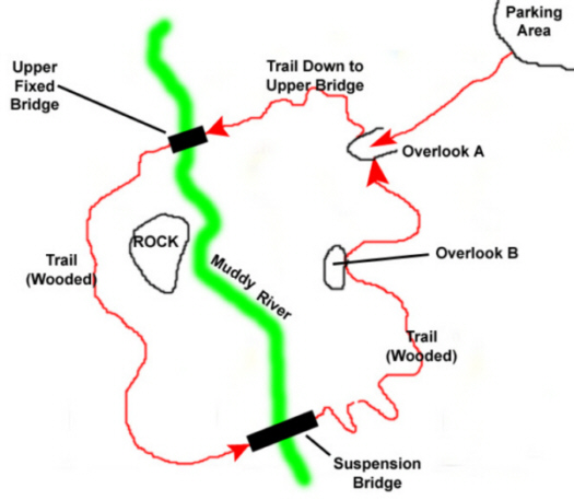
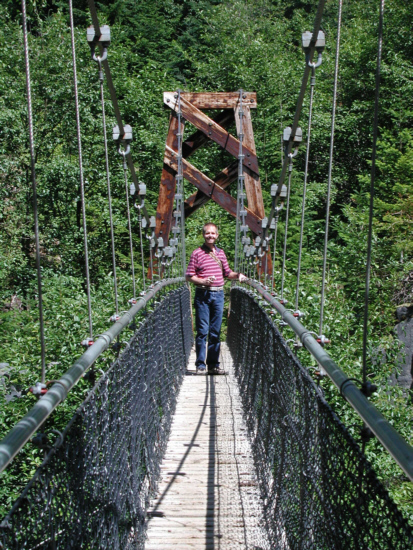
The first section of Lava Canyon Trail descends a steep series of switchbacks to several views of the canyon (.5 mile). Platforms are in place with interpretive signs. This section is paved and accessible to wheelchairs, although it's very steep and assistance is usually needed. From here, a signed loop crosses the river via a bridge and follows the river down. This section of river has many pools and channels carved into the bedrock. The loop crosses back over the river via a high suspension bridge (1 mile). Although Lava Canyon Trail continues to a lower trailhead (2.5 miles), we will be heading back after we cross the lower suspension bridge.
From this overlook, we could see most of Lava Canyon and the Muddy River that runs through it. Behind me and to the right in the picture there is a bridge across the Muddy River. This, we found out, was the upper of two different bridges that we would encounter on the trail. This first bridge spans the river just below the first waterfall. Our trail will take us down to that bridge, across it, and then left on the other side of the river.
|
|
After I'd taken my picture and movie, I walked to the far end of the bridge where Fred, who had walked down the trail a bit, could turn and get a picture of me coming off the fixed bridge.
 |
|
|
While I was making this movie, Fred climbed back a bit higher up on the bare rock face to get his own picture of the upper portion of Lava Canyon.
|
|
 |
|
|
I had some fun with Fred out on the bridge, but when he got near to the other side of the bridge (and felt a bit safer), he got a beautiful view of the lower cascade of Lava Falls.
|
|
While I was here in the middle of the bridge, I also took a picture looking straight down at the Muddy River flowing beneath my feet.
Finally, and again from the middle of the bridge, I made a movie panorama of the river, the bridge and Fred. At the same time, Fred was taking a movie of his own from the other side of the bridge. You can watch both these movies with the players below:
|
Fred went up the trail a little ways, and turned to take a photo of me and the suspension bridge which, by this time, I have crossed. I followed Fred up the trail, and found a great spot to take a picture of Fred and the distant valley. I turned around from that same spot and got my own picture looking down on the suspension bridge.
At this point, the trail entered a series of switchbacks through the woods, finally bringing us out at Overlook B, where, once again, we could see the upper bridge and second cascade, but this time with an entirely different view from the other side of the canyon. The trail continued to climb until we were almost back at Overlook A, at which point I took our last picture of the upper bridge and cascade. This brought us back to the first overlook where we spent a bit more time just enjoying the scenery before walking back to the parking area and the car. We headed off back down the park road towards Ape Cave, but we had not gone very far before Fred asked me to pull over so he could get this really spectacular view of Mt. St. Helens.
You can return to the Page Index or continue on with the next section.
We Stop for a Snack at Yale Lake
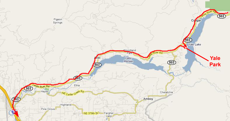 |
When we came around the southwest end of Yale Lake and Resevoir, we stopped at Yale Park to have a soda and enjoy the scenery.
|
|
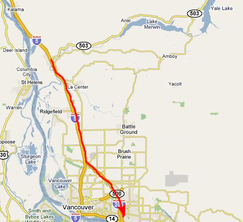
Then we continued on west along 503, reaching Interstate 5 about twenty minutes later.
You can return to the Page Index or continue on with the next section.
The Drive to Sandy, Oregon
 |
 |
We took the exit for Oregon Route 26- the Mt. Hood Scenic Highway and followed that southeast through the suburbs of Portland.
 |
There was no Super 8 Motel here (our usual haunt) but there was a reasonably-priced Best Western, and so we turned in there.
 |
We found our room with no problem, and it was pretty nice, on the back side of the hotel with a view into the trees. It was still quite light outside, although it was just after six in the evening, so we decided to postpone dinner for a while and go for a drive out towards Mt. Hood. The last time I had tried this, clouds had obscured the mountain, but tonight that wouldn't matter, as we would be at Mt. Hood tomorrow.
So we drove east on the scenic highway. Beyond Sandy, the road descends a bit into heavy forest, so we could not see the mountain from the road much. When we got closer, we could see the mountain occasionally, but to get good views we'd have to almost all the way there. So we just enjoyed the drive out into the forest and back to the Sandy Inn. We took a swim in the indoor pool, then got changed and, following a recommendation from the desk clerk, had a really nice meal just down the road in Sandy at the Tollgate Inn Restaurant.
You can return to the Page Index or continue to a different day of our Oregon trip.
|
July 20, 2004: Oregon Trip Day 4 |
|
July 18, 2004: Oregon Trip Day 2 |
|
Return to Main Index for Oregon Trip Pictures |